
The depopulated village of Khirbat al-Muntar / District of Safed
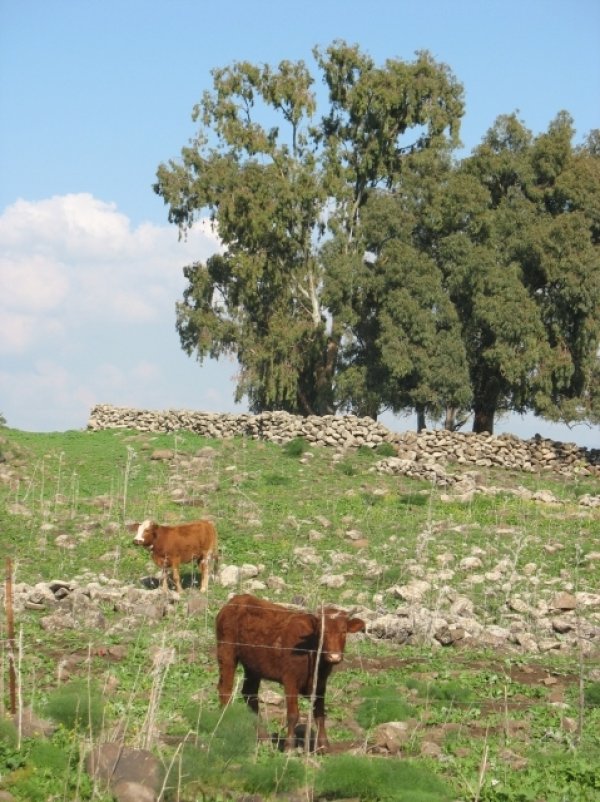
Khirbat al-Muntar
About the depopulated village of Khirbat al-Muntar
- District
- Safed
- Date Khirbat al-Muntar was occupied
- 01 May 1948
- Military operation
- Operation Yiftach
- Brigade that carried it out
- Palmach، The Oded Brigade
- Who defended the village
- Syrian Army
- Distance from the governorate centre
- 8.5 (km) East of Safad
- Elevation above sea level
- 250 m
- Cause of displacement
- Expulsion by Zionist troops
- Extent of destruction
- The village has been completely destroyed
- Ethnic cleansing
- The village has been completely ethnically cleansed by between 1949-1956.
Hover a dot to read the village name, or click to open its card.
Khirbat al-Muntar – Depopulated Palestinian Hamlet of Safad
Khirbat al-Muntar, also rendered in some Palestinian sources as Khirbat al-Manzar, was a small Palestinian locality in the Safad Subdistrict. It stood approximately 8.5 kilometers east of Safad at an average elevation of about 250 meters above sea level.
The hamlet occupied volcanic terrain that sloped gradually northward toward the al-Hula Plain and drained into Wadi Shahyan. Its position between the Rosh Pina area and the Banat Ya'qub Bridge placed it near a major route linking eastern Galilee with the road toward Damascus.
Khirbat al-Muntar differed from larger villages because the Mandate Palestine Index Gazetteer classified it as a small hamlet or farm. It did not appear as an independent population and land unit in the 1945 Village Statistics; instead, the relevant land and population were statistically recorded under Mahanayim.
Basic Information
| Field | Information |
|---|---|
| Name | Khirbat al-Muntar |
| Arabic name | خِرْبَة المُنْطار |
| Alternative form | Khirbat al-Manzar in some Palestinian sources |
| Subdistrict | Safad |
| Location | East of Safad on volcanic terrain sloping toward the al-Hula Plain |
| Distance from Safad | Approximately 8.5 km |
| Average elevation | Approximately 250 m above sea level |
| Palestine Grid | 205/265 |
| Pre-Nakba population | No independently documented official village figure |
| Population in 1945 | No separate figure; the 110 people recorded under Mahanayim were the population of that official statistical unit, not Khirbat al-Muntar |
| Independent village land area | No separate figure established; 2,472 dunums belonged to the Mahanayim statistical unit |
| Earliest probable attacks | Likely during Operation Yiftach in spring 1948; no definitive village-specific date |
| Military situation in June 1948 | The hamlet lay close to the Mahanayim–Mishmar ha-Yarden front involving Syrian forces and the 'Oded Brigade, later 'Oded and Carmeli |
| Status after 1949 | On the periphery of the Israel-Syria Demilitarized Zone |
| Final depopulation | No independently documented date; if still inhabited after 1949, the residents were probably removed during the 1949–1956 period |
| Israeli settlements on village lands | None according to Walid Khalidi and PalQuest |
Name
PalQuest and Walid Khalidi use the form Khirbat al-Muntar, while some Palestinian documentation uses Khirbat al-Manzar.
No sufficiently documented linguistic derivation of the name was located in the principal sources consulted, so no speculative etymology is adopted.
Location and Boundaries
Khirbat al-Muntar stood in a volcanic area east of Safad that descended gradually toward the al-Hula Plain and was drained by Wadi Shahyan.
Palestinian local documentation places Yarda and al-Wayziyya to the north, al-Dardara to the northeast, Mansurat al-Khayt to the east, Zanghariyya and Tuba encampments to the south and southwest, al-Ja'una to the west, and Fir'im and Mughr al-Khayt to the northwest.
The site lay close to the route connecting the Safad area with Banat Ya'qub Bridge and onward toward Damascus, giving the area military and geographic importance in 1948.
Nature of the Settlement
Khirbat al-Muntar was a very small rural settlement. The Mandate Palestine Index Gazetteer classified it as a hamlet or farm rather than as a large village.
In 1840, American traveler Edward Robinson recorded an encampment of Turkish and Kurdish nomads in the area and also observed Arab Bedouin encampments.
This description documents nineteenth-century settlement patterns but does not provide a twentieth-century population count.
Population Statistics
| Year | Population | Note |
|---|---|---|
| 1922 | No independently documented figure | No population is inferred from neighboring localities |
| 1931 | No independently documented figure | The hamlet was not separately tabulated in the official material used here |
| 1944/45 | No independent Khirbat al-Muntar figure | Village Statistics records 110 people under Mahanayim, all in the Jewish population category; this is not a Khirbat al-Muntar population figure |
| 1948 | No reliable independent estimate | No population is extrapolated mathematically |
Relationship with Fir'im
Palestinian community testimony from Fir'im describes Khirbat al-Muntar as an important agricultural center associated with Fir'im's farmers.
According to this testimony, agricultural workers stayed at al-Muntar during plowing and harvest seasons, stored straw and farming equipment there, and returned to Fir'im during summer for the fig and cactus harvests.
This account helps explain the seasonal and agricultural character of the locality and may partly explain the absence of a large independent population in official statistics. It does not establish that every inhabitant of Khirbat al-Muntar originated from Fir'im.
Mahanayim and Land Purchases
In the late nineteenth century, Baron Edmond de Rothschild purchased much of the land in the area around Khirbat al-Muntar.
Mahanayim was first established in 1898 on the purchased land, but the settlement proved economically unsuccessful and was abandoned.
Khalidi states that Arabs from Khirbat al-Muntar continued cultivating these lands even though they no longer formally held legal title, at least until Mahanayim was re-established in 1939.
The 1945 Land Statistics – Methodological Note
Khirbat al-Muntar does not appear as an independent land unit in Village Statistics 1945. The relevant figures are recorded under Mahanayim.
The following table therefore represents the Mahanayim statistical unit, not an independently demarcated Khirbat al-Muntar land area:
- Arab52 dunums2%
- Jewish2,407 dunums97%
- Public13 dunums<1%
The figures balance exactly: 52 + 2,407 + 13 = 2,472 dunums.
The original Government of Palestine categories—Arab, Jewish, and Public—are retained here rather than replacing them with terminology not used in the official table.
Why 2,472 Dunums Is Not an Independent Khirbat al-Muntar Land Total
Several secondary sources reproduce 2,472 dunums as the land area of Khirbat al-Muntar.
The official table, however, records the figure under Mahanayim and combines land registered in different ownership categories within that statistical unit. It cannot therefore be treated automatically as a separately demarcated cadastral area belonging exclusively to Khirbat al-Muntar.
Likewise, the fifty dunums recorded as built-up land in the Mahanayim land-use table should not be presented as the built-up area of the Palestinian hamlet itself.
Economy and Agriculture
Agriculture and pastoral activity formed the economic basis of Khirbat al-Muntar.
Khalidi records that Arabs from the hamlet continued cultivating nearby lands through at least 1939 even after legal ownership of much of the area had changed.
Palestinian community testimony from Fir'im likewise describes the site as a seasonal center for plowing, harvesting, and storing straw and agricultural equipment.
No independent Khirbat al-Muntar land-use table exists from which precise cereal, olive, or orchard acreage can safely be calculated.
Education and Services
No independently documented school, medical facility, or administrative institution at Khirbat al-Muntar was located in the principal sources consulted.
Given the small and agricultural character of the settlement, no such institution is assumed without supporting documentation.
Religious Sites and Cemetery
No independently documented mosque or named shrine has been located for Khirbat al-Muntar in the principal sources used here.
The village cemetery survived as a visible feature of the site, and Khalidi's later field description records that it was being used by Bedouin residents of nearby Tuba.
Archaeological Remains
Palestinian local documentation, citing researcher Shukri 'Arraf, records archaeological remains at Khirbat al-Muntar including building foundations, dressed stones, a column, and a column base.
The same local source provides additional claims concerning mosaics and ancient coins, but portions of its chronological attribution are internally inconsistent. This article therefore does not assign precise archaeological dates to those finds without an independent specialist source.
Operation Yiftach and the Earliest Attacks
Khalidi considers it likely that the earliest attacks on Khirbat al-Muntar occurred during Operation Yiftach in spring 1948.
Military orders in eastern Galilee called for destroying bridges along approaches from Syria and Lebanon and concentrating forces in the Rosh Pina–Ayelet ha-Shahar area.
Khirbat al-Muntar lay between Rosh Pina and Banat Ya'qub Bridge, placing its surroundings within the military zone affected by the operation.
Khalidi does not, however, identify a specific day on which the hamlet was captured or establish that its population was permanently removed at this stage.
Was Khirbat al-Muntar Occupied on 1 May 1948?
Some Palestinian secondary sites give 1 May 1948 as the occupation date.
Khalidi does not provide this date. He states only that the first attacks probably occurred during Operation Yiftach.
This article therefore does not treat 1 May as a verified date of final occupation or depopulation.
The June 1948 Front
After operations against Syrian positions along the Jordan River, the Yiftach Brigade was withdrawn from the area in early June 1948.
On 10 June Syrian forces crossed the Jordan and captured Mishmar ha-Yarden.
The following day they advanced west toward positions around Mahanayim, immediately near Khirbat al-Muntar, but were stopped by units of the 'Oded Brigade.
The first truce began in this sector on 11 June and lasted until 9 July, leaving the nearby front relatively stable.
After the truce, the 'Oded and Carmeli brigades launched renewed attempts to advance east toward Mishmar ha-Yarden but failed.
The participation of 'Oded and Carmeli in this front does not establish that either brigade independently captured Khirbat al-Muntar. The source describes military operations near the hamlet, not a documented village-specific assault.
The 1949 Armistice Agreement
On 20 July 1949, Israel and Syria signed their General Armistice Agreement.
The agreement was signed in a tent near Mahanayim and close to the site of Khirbat al-Muntar.
The resulting arrangements created a Demilitarized Zone along parts of the former Palestine-Syria boundary.
Khalidi states that Khirbat al-Muntar lay on the periphery of the Demilitarized Zone, which is more precise than stating that the entire hamlet was definitively located inside the zone.
Was 20 July 1949 the Occupation Date?
Palestine Remembered displays 20 July 1949 in its occupation-date field.
That date, however, is the date on which the Israel-Syria Armistice Agreement was signed near the site. Khalidi does not document a military assault on Khirbat al-Muntar on that day.
This article therefore does not use 20 July 1949 as a verified military occupation date.
The Population between 1949 and 1956
Khalidi does not establish whether Khirbat al-Muntar was still inhabited in July 1949.
He states that if residents remained there, they probably experienced the same fate as Palestinians in villages located more fully within the Demilitarized Zone, where Israeli authorities used direct and indirect pressure to remove inhabitants between 1949 and 1956.
No single independently documented final depopulation date is therefore available for Khirbat al-Muntar.
Was 30 October 1956 the Final Depopulation Date?
A Palestinian village-history project gives 30 October 1956 as the final occupation date.
The date is reconstructed by analogy with events affecting other Demilitarized Zone villages rather than being supported by an independent village-specific document establishing the removal of Khirbat al-Muntar's residents on that exact day.
The more defensible conclusion is: if the hamlet remained inhabited after 1949, its residents were probably removed sometime during the 1949–1956 period, but the precise final date is not independently documented.
Cause of Depopulation
Khirbat al-Muntar's depopulation cannot be reduced to one independently documented military attack.
The surrounding area was affected by Operation Yiftach and then became an active Syrian-Israeli front during June and July 1948.
If residents continued living at the site after the war, the final phase of displacement was probably linked to the pressures imposed on Arab residents of the Demilitarized Zone between 1949 and 1956.
Destruction
Khirbat al-Muntar's buildings were eventually destroyed, but the principal sources do not establish a precise demolition date.
Khalidi's fieldwork nevertheless recorded extensive stone rubble scattered across the former village site.
The chronology of military operations and population displacement should therefore be distinguished from the undated demolition of the built environment.
Ethnic Cleansing in Source Classification
Palestine Remembered classifies Khirbat al-Muntar using the term “ethnic cleansing.” The term is retained here only as an attributed source classification.
The more specifically documented facts are that the area was affected by repeated military operations in 1948, that Khalidi does not establish the exact date on which the population disappeared, and that if residents remained after 1949 they likely faced pressures similar to those imposed on Palestinian communities of the Demilitarized Zone between 1949 and 1956.
Occupation and Depopulation Chronology
| Date | Event |
|---|---|
| Spring 1948 | The earliest attacks probably occur during Operation Yiftach; no definitive village-specific capture date is documented. |
| Early June 1948 | The Yiftach Brigade withdraws from the sector following operations along the Jordan River. |
| 10 June 1948 | Syrian forces cross the Jordan River and capture Mishmar ha-Yarden. |
| 11 June 1948 | Syrian forces advance toward positions around Mahanayim near Khirbat al-Muntar and are stopped by the 'Oded Brigade. |
| 11 June–9 July 1948 | The front near the hamlet remains relatively stable during the first truce. |
| After 9 July 1948 | The 'Oded and Carmeli brigades make renewed unsuccessful attempts to advance toward Mishmar ha-Yarden. |
| 20 July 1949 | The Israel-Syria General Armistice Agreement is signed near Mahanayim and Khirbat al-Muntar; this is not a documented village occupation date. |
| After July 1949 | Khirbat al-Muntar lies on the periphery of the Demilitarized Zone; the source does not establish whether it remained inhabited. |
| 1949–1956 | If villagers remained, Khalidi considers it likely that they were subjected to removal pressures similar to those affecting Arab villages in the Demilitarized Zone. |
| By 1956 | No Palestinian residential community remained at the site; the precise final depopulation day is not independently documented. |
Israeli Settlements on Khirbat al-Muntar's Lands
According to Walid Khalidi and PalQuest, no Israeli settlement was established on Khirbat al-Muntar's village lands.
Mahanayim, first established in 1898 and re-established in 1939, lies approximately one kilometer northeast of the village site.
A distinction must be maintained between Rothschild-era land purchases in the wider area, the 1945 statistical aggregation of the locality with Mahanayim, and the actual cadastral location of the settlement. Khalidi explicitly does not classify Mahanayim as a settlement established on Khirbat al-Muntar's village lands.
Khirbat al-Muntar Today
According to the field description used by Walid Khalidi before the publication of All That Remains in 1992, stone rubble was scattered throughout the former village site.
Grass and thorny vegetation covered much of the area, together with a few cypress trees, and a cattle enclosure stood nearby.
The village cemetery was being used by Bedouin residents of nearby Tuba, while portions of the surrounding land served as grazing ground.
This description represents documented historical fieldwork conducted before the 1992 publication of All That Remains, rather than a comprehensive direct survey of Khirbat al-Muntar's condition in 2026.
Sources
- PalQuest – Interactive Encyclopedia of the Palestine Question: Khirbat al-Muntar
- PalQuest – Operation Yiftach
- Palestine Remembered – Khirbat al-Muntar, Safad Subdistrict
- Palestine Remembered – Khirbat al-Muntar entry from Walid Khalidi's All That Remains
- Sabil Library – Village Statistics 1945: Mahanayim population and land ownership
- Village Statistics 1945 – Safad land-use tables
- Palestinian Villages Encyclopedia – Khirbat al-Muntar / al-Manzar
- Palestine Remembered – Palestinian testimony on Fir'im and Khirbat al-Muntar as an agricultural center
- United Nations – Israel-Syria General Armistice Agreement, 20 July 1949
Photos from the village's people
Photos sent in by visitors and published after review.
Add a photo of this village
Log in to add photos of this village.
Other villages from Safed



More from the archive


 Download Our Palestine App
The whole archive in the palm of your hand: depopulated villages, the Nakba, the massacres and Al-Aqsa — free, with no ads to erase the story.
Download Our Palestine App
The whole archive in the palm of your hand: depopulated villages, the Nakba, the massacres and Al-Aqsa — free, with no ads to erase the story.



Comments
No comments yet — be the first to write one.
Add your comment
Name and email are optional. Comments appear after review.