
The depopulated village of Al-Qudayriyya / District of Safed
Al-Qudayriyya
About the depopulated village of Al-Qudayriyya
- District
- Safed
- Date Al-Qudayriyya was occupied
- 04 May 1948
- Population in 1948
- 450
- Military operation
- Operation Yiftach
- Brigade that carried it out
- Palmach
- Who defended the village
- Local militia & Arab Liberation Army
- Distance from the governorate centre
- 6.5 (km) South of Safad
- Elevation above sea level
- 150 m
- Cause of displacement
- Expulsion by Zionist troops
- Extent of destruction
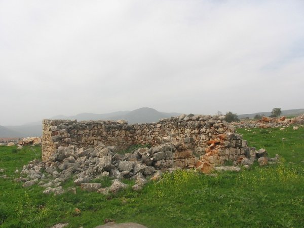
- The village has been completely destroyed, and only few structures are still standing.
- Ethnic cleansing
- al-Qudayriyya inhabitants were completely ethnically cleansed.
- Settlements built on the built-up area of Al-Qudayriyya after 1948
- Kahal
Hover a dot to read the village name, or click to open its card.
Borders of the depopulated village of Al-Qudayriyya
al-Qudayriyya: A Depopulated Palestinian Village in the Safad District
al-Qudayriyya was a Palestinian village in the Safad District, situated in the eastern Galilee Mountains approximately 6.5 km south of Safad, at an average elevation of about 150 metres above sea level. The village occupied land sloping southeast toward Lake Tiberias, while Wadi al-'Amud passed approximately 1 km to its west. Most of its Muslim inhabitants were herdsmen, although some practiced agriculture. Haganah forces attacked al-Qudayriyya on 4 May 1948 and expelled its inhabitants during Operation Matate (“Broom”), a sub-operation conducted in the context of Operation Yiftach during the Nakba and the occupation of Palestine in 1948.
Location of al-Qudayriyya
al-Qudayriyya stood in the eastern Galilee Mountains on land that sloped southeast and overlooked Lake Tiberias.
The village was approximately 6.5 km south of Safad and had an average elevation of about 150 metres above sea level.
Wadi al-'Amud, a perennial watercourse flowing from the vicinity of Safad toward Lake Tiberias, passed about 1 km west of the village.
Nearby Palestinian localities in the wider area included 'Akbara, al-Ja'una, Jubb Yusuf, al-Shuna, Yaquq, al-Tabigha, and al-Samakiyya, at varying distances and directions from al-Qudayriyya.
Landscape and Architecture
al-Qudayriyya stood in relatively rugged mountainous terrain on the eastern slopes of the Galilee.
Khalidi's principal PalQuest entry does not provide a sufficiently detailed description of the village's internal plan or the building materials used in all of its houses.
The published 1944/45 land-use table also does not give a separate built-up-area figure, so no unsupported residential acreage is added.
Population of al-Qudayriyya
The inhabitants of al-Qudayriyya were all Muslim.
The official 1922 Census of Palestine recorded 194 inhabitants.
By the 1931 census, the population had fallen to 72, living in 14 houses.
The population then rose to 390 in the official 1944/45 statistics.
The principal approved sources do not provide a documented explanation for the sharp decline between 1922 and 1931, so no cause is assumed here.
Population of al-Qudayriyya in selected years
- 1922194Official British Mandate census; all Muslim
- 193172Official census; all Muslim
- 1944/45390Official statistics; all Arab Muslims
- 1948452Later estimate published by Palestine Remembered
- Estimated refugees in 19982,778Later estimate published by Palestine Remembered
Number of Houses
Number of houses in al-Qudayriyya
- 193114Official British Mandate census
- 194887Later estimate published by Palestine Remembered
Education and Public Services
Khalidi's principal PalQuest entry and the official statistics used here do not provide sufficiently documented information about an independent school, clinic, or other educational institution in al-Qudayriyya before the Nakba.
No unsupported educational details are therefore added.
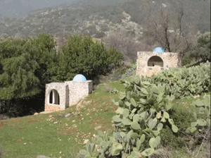
The Shrine of al-Shaykh al-Rumi
A shrine dedicated to a local holy man known as al-Shaykh al-Rumi stood in the center of the village.
The shrine was located near the archaeological remains of Khirbat al-Nuwayriyya.
The principal sources used here do not provide a securely documented construction date for the shrine or a detailed biography of al-Shaykh al-Rumi, so the article is limited to the established information concerning its existence and location.
Economic Life in al-Qudayriyya
Most inhabitants of al-Qudayriyya were herdsmen, making livestock raising the principal documented livelihood.
Some villagers also practiced agriculture.
In 1944/45, a total of 2,029 dunums was planted with cereals.
The official land-use table does not separately record irrigated plantations, citrus, or other agricultural categories, so no unsupported crop figures are added.
Land Ownership in al-Qudayriyya
The total registered land area of al-Qudayriyya was 12,487 dunums in the 1944/45 statistics.
Land ownership in al-Qudayriyya, 1944/45
- Palestinian12,487 dunums100%
- Transferred to Zionists0 dunums0%
- Communal/Public0 dunums0%
According to the official ownership statistics, all registered land in al-Qudayriyya was Arab/Palestinian. No Jewish or public land was recorded.
Land Use in al-Qudayriyya, 1944/45
Land use in al-Qudayriyya, 1944/45
- Palestinian
- Cereals2,029 dunums
- Non-cultivable land10,458 dunums
The recorded cultivated or cultivable area amounted to 2,029 dunums, approximately 16 percent of the village lands.
The published statistics classify 10,458 dunums, approximately 84 percent, as non-cultivable.
The PalQuest table does not provide a separate built-up-area figure. Since the cereal and non-cultivable categories already add up to the full registered land area, no speculative residential acreage is added.
Archaeology of al-Qudayriyya
Khirbat al-Nuwayriyya was the principal archaeological site associated with al-Qudayriyya.
It contained heaps of dressed building stone and rock-cut wine presses.
Khalidi describes these remains as evidence that the location had been inhabited during the Roman and Byzantine periods.
The shrine of al-Shaykh al-Rumi stood near the ruins, placing a local religious landmark alongside much older archaeological remains in the center of the village area.
Operation Yiftach and Operation Matate
The attack on al-Qudayriyya occurred within the broader Zionist campaign to seize eastern Galilee during Operation Yiftach.
Operation Yiftach ran from 15 April to 25 May 1948.
On 4 May, a limited sub-operation known as Operation Matate (“Broom”) was launched to remove Palestinian inhabitants from an area east of Safad toward the Jordan Valley and establish a broader corridor under Zionist control.
The attack on al-Qudayriyya formed part of this sub-operation.
Operation Matate took place approximately one week before the fall of Safad and helped increase military and psychological pressure on the city and surrounding Palestinian communities.
Occupation and Depopulation of al-Qudayriyya
Haganah forces attacked al-Qudayriyya on 4 May 1948.
The assault resulted in the expulsion of the village's inhabitants by the occupying forces.
Arab Liberation Army commander Fawzi al-Qawuqji also reported the village's occupation at the time. In a cable sent the following day, he stated that the Second Battalion of the Yarmuk Regiment of the Arab Liberation Army had defended the area.
Palestine Remembered lists the Palmach's First Battalion among the attacking forces and associates the attack with Operation Matate and Operation Yiftach.
Khalidi's dedicated PalQuest entry, however, uses the broader formulation “Haganah forces” and does not independently establish that the First Battalion alone constituted the village-specific assault force.
This article therefore distinguishes between Palestine Remembered's unit attribution and Khalidi's more cautious description.
Khalidi also notes that some other villages occupied during Operation Matate were quickly destroyed by Haganah units acting under orders to blow up houses.
The source does not provide a separate detailed account proving that every such demolition measure was carried out in al-Qudayriyya immediately on the first day, so the experience of other villages in the operation is not automatically attributed to al-Qudayriyya.
- Date of attack and occupation: 4 May 1948.
- Broader military operation: Operation Yiftach.
- Sub-operation: Operation Matate (“Broom”).
- Attacking force in Khalidi's account: Haganah forces.
- Unit listed by Palestine Remembered: Palmach First Battalion among the attacking forces.
- Defenders: Second Battalion of the Yarmuk Regiment, Arab Liberation Army, according to Fawzi al-Qawuqji's cable.
- Fate of the population: expelled from the village as a result of the assault.
Was There a Massacre at al-Qudayriyya?
Palestine Remembered's summary field states that a massacre occurred at al-Qudayriyya.
However, the detailed historical narrative derived from Khalidi and the PalQuest village entry describe the assault, occupation, and expulsion without documenting a mass killing inside the village or providing a casualty figure.
This article therefore does not present a “massacre at al-Qudayriyya” as an established historical fact without additional corroborating evidence from the approved sources.
Israeli Settlement on al-Qudayriyya's Lands
The Israeli settlement of Kachal, also rendered Kahal, was established in 1980 on al-Qudayriyya's lands.
It lies southeast of the former Palestinian village site.
- Kachal/Kahal: established in 1980 on al-Qudayriyya's lands, southeast of the village site.
al-Qudayriyya Today
According to the field description published by Walid Khalidi in All That Remains, rubble from destroyed Palestinian houses was scattered throughout the former village site.
Wild grass and other vegetation covered much of the area.
A small number of structures still stood at the time of Khalidi's documentation, including one with an arched entrance.
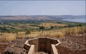
The concrete lining of a village well also remained visible.
The surrounding lands were used as pasture.
Palestine Remembered preserves later community documentation of the site. Photographs taken on 18 February 2005 show the remains of the house of village mukhtar Khalid al-Mu'ajjil, the village cemetery, a well, and general views of the ruins.
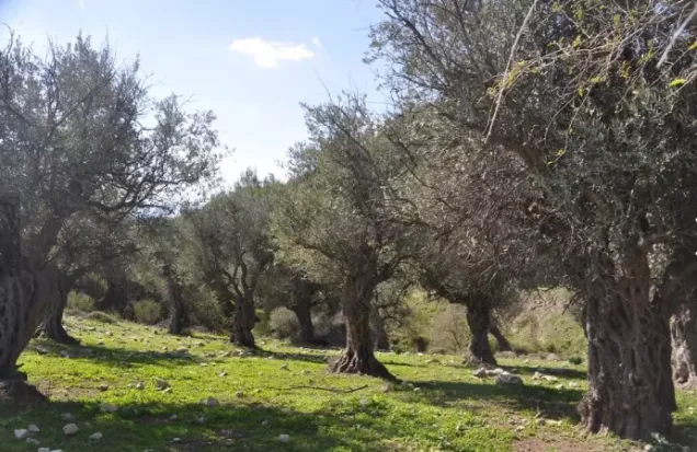
Further photographs taken on 5 April 2008 show the mukhtar's house remains, the cemetery, and surviving olive trees on the western side of the site.
These photographs are useful community documentation but do not constitute a systematic independent archaeological or field survey.
Khalidi's principal field documentation predates the publication of his 1992 book and includes a photograph of a surviving arched entrance taken in September 1987.
Neither this older description nor the later community photographs should be presented as direct verification of the precise condition of every part of al-Qudayriyya in 2026. The approved sources used here do not provide a sufficiently comprehensive independent contemporary field survey.
Sources
- PalQuestPalQuest – Interactive Encyclopedia of the Palestine Question: al-Qudayriyya
- PalQuestPalQuest – Operation Yiftach
- Palestine RememberedPalestine Remembered – al-Qudayriyya, Safad District
- Palestine RememberedPalestine Remembered – al-Qudayriyya entry from All That Remains
- archive.orgGovernment of Palestine – Census of Palestine, 1922
- pcbs.gov.psGovernment of Palestine – Census of Palestine, 1931
- maktabatsabil.comGovernment of Palestine – Village Statistics, 1945
- Institute for Palestine StudiesInstitute for Palestine Studies – All That Remains, Walid Khalidi
Photo gallery




Photos from the village's people
Photos sent in by visitors and published after review.
Add a photo of this village
Log in to add photos of this village.
Other villages from Safed


More from the archive

 Download Our Palestine App
The whole archive in the palm of your hand: depopulated villages, the Nakba, the massacres and Al-Aqsa — free, with no ads to erase the story.
Download Our Palestine App
The whole archive in the palm of your hand: depopulated villages, the Nakba, the massacres and Al-Aqsa — free, with no ads to erase the story.



Comments
No comments yet — be the first to write one.
Add your comment
Name and email are optional. Comments appear after review.