
The depopulated village of Al-Zanghariyya / District of Safed
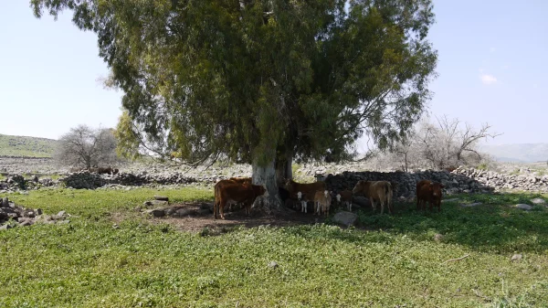
Al-Zanghariyya
About the depopulated village of Al-Zanghariyya
- District
- Safed
- Date Al-Zanghariyya was occupied
- 04 May 1948
- Population in 1948
- 970
- Military operation
- Operation Yiftach
- Distance from the governorate centre
- 8.5 (km) South East of Safad
- Elevation above sea level
- 250 m
- Cause of displacement
- Expulsion by Zionist troops
- Extent of destruction
- The village has been burned and destroyed on the 17th of June 1948.
- Ethnic cleansing
- al-Zanghariyya inhabitants were completely ethnically cleansed.
- Settlements built on the built-up area of Al-Zanghariyya after 1948
- Refugees fled eastwards into Syria.
Hover a dot to read the village name, or click to open its card.
Borders of the depopulated village of Al-Zanghariyya
al-Zanghariyya (Zuhluq) – Safad Subdistrict
Al-Zanghariyya, also known as Zuhluq, was a depopulated Palestinian village in the Safad subdistrict of Galilee. It stood approximately 8.5 km southeast of Safad at an average elevation of about 250 meters, overlooking the Jordan Valley and facing the Golan Heights. Its lands covered 27,918 dunums, and its officially estimated population in 1944/45 was 840. The village was depopulated on 4 May 1948 during Operation Matate, or Operation Broom, a sub-operation of Operation Yiftach.
Location of al-Zanghariyya
Al-Zanghariyya was situated in a hollow on the side of a broad hill that sloped gently eastward. It faced the Golan Heights and overlooked the Jordan Valley. Several springs lay northwest of the village along Wadi al-Ghara.
A dirt road connected the village to the Safad–Tiberias highway, linking it with Safad and the region north of Lake Tiberias and along the Jordan Valley.
Palestinian geographical sources place a number of villages and communities around al-Zanghariyya, including al-Wayziyya, Mansurat al-Khayt, al-Butayha, Jubb Yusuf, and al-Ja'una, together with the wider communities of Arab al-Shamalina, al-Samakiyya, and Tuba. Since sources differ in some details of the cadastral boundaries, a list of surrounding villages should not be treated as a precise land-boundary survey without consulting detailed cadastral maps.
The Names al-Zanghariyya and Zuhluq
The village was named after the Bedouin Arab al-Zanghariyya tribe, whose members initially used the location as a camping ground and gradually settled there.
Walid Khalidi suggests that the alternative name Zuhluq was associated with the nature of the hillside on which the village stood, which was susceptible to landslides. Al-Zanghariyya and Zuhluq were therefore two names for the same village, not two separate settlements.
Built Environment
The village houses were constructed primarily of mud and stone and were divided into two principal clusters. The eastern group was known as Zanghariyya al-Sharqiyya, while the western group was called Zanghariyya al-Gharbiyya.
The two clusters were approximately 275–365 meters apart. They were parts of the same village rather than independent villages.
Population of al-Zanghariyya
- 1922374Official Census of Palestine, 1922
- 1931526Official Census of Palestine, 1931
- 1944/45840Official Mandate Government estimate; not a new population census
- 1948974Later estimate published by Palestine Remembered; not an official census
- 19985,984 refugees and descendantsLater estimate published by Palestine Remembered
The methodology of All That Remains explains that the 1944/45 village population figures were official estimates prepared by the Mandatory Government's Department of Statistics on the basis of the 1931 census. They should therefore be described as official statistics or estimates rather than as a separate 1945 census.
Number of Houses
- 193197Official census figure
- 1948179Later estimate published by Palestine Remembered; not an official census figure
Land Ownership in al-Zanghariyya
The village lands totaled 27,918 dunums. Palestine Remembered presents its simplified ownership table using the following terminology:
- Palestinian27,856 dunums100%
- Transferred to Zionists0 dunums0%
- Communal/Public62 dunums<1%
PalQuest, reproducing the official 1944/45 categories, records 27,856 dunums as Arab land and 62 dunums as Public land, for the same total of 27,918 dunums. No land is listed under Jewish ownership.
Land Use in 1944/45
- Arab
- Public
- Cereals7,265 dunums
- Non-cultivable20,653 dunums
The land-use categories add correctly to the village's total area. The available table does not provide a separately documented built-up-area figure, and the 62 dunums of Public land should not be reinterpreted as a built-up-area total.
Economic Life in al-Zanghariyya
Pastoralism was a major component of the village economy, reflecting both the Bedouin origins of Arab al-Zanghariyya and the extensive grazing land around the village. Herdsmen moved their animals between the Jordan Valley in winter and the eastern slopes of the Galilee hills in summer.
The villagers also practiced both rain-fed and irrigated agriculture. They cultivated cereals, fruit, and onions, with 7,265 dunums allocated to cereals in 1944/45.
Sheep, water buffalo, and other livestock were raised by the villagers. Fishing in Lake Tiberias and the Jordan River was also an important livelihood for a segment of the population.
Water
Several springs lay northwest of the village along Wadi al-Ghara. Together with rainfall, these water sources supported agriculture, allowing al-Zanghariyya to combine rain-fed cultivation with irrigated farming.
The principal sources reviewed do not provide a sufficiently documented comprehensive list of all the village's springs and wells, so unsupported names have not been added here.
Education in al-Zanghariyya
Archival material indexed by Palestine Remembered confirms the existence of a school in al-Zanghariyya during the British Mandate. One document dated 18 September 1946 concerns the appointment of Muhammad Abd al-Hadi al-Zuhuri as an additional teacher in the village.
This provides documentary evidence of organized schooling in al-Zanghariyya by that date. The core sources reviewed, however, do not provide a sufficiently verified founding date or a reliable student enrollment figure, and none has therefore been assigned.
Archaeological Remains
Walid Khalidi records evidence of earlier habitation at al-Zanghariyya, including the foundations of former buildings and an enclosure constructed of basalt stone.
Other Palestinian local sources list several archaeological ruins in the surrounding area, but these sites would require separate archaeological verification before being assigned definitive dates or functions. This article therefore limits itself to the evidence recorded by the principal source.
Operation Yiftach and Operation Matate / Broom
Operation Yiftach began on 15 April 1948 and continued until 25 May. It was intended to establish control over eastern Galilee before the end of the British Mandate. Palmach forces played the central military role, and the Palmach's First Battalion spearheaded Operation Yiftach as a whole.
On 4 May 1948, the Haganah launched Operation Matate, or Operation Broom, as a sub-operation within Yiftach. It targeted the area east of Safad and near the Jordan River, and specifically included al-Zanghariyya, al-Tabigha, and Arab al-Shamalina.
The orders issued to Palmach company commanders before the operation explicitly instructed them to attack these communities, expel their inhabitants, and demolish their houses. Khalidi reproduces this information from accounts of the operational orders.
Occupation and Depopulation of al-Zanghariyya
As Palmach columns approached al-Zanghariyya and the other targeted communities on 4 May 1948, the inhabitants fled eastward toward Syria.
A cable sent by the commander of the Arab Liberation Army to its High Command in Syria confirmed that al-Zanghariyya was occupied on 4 May and stated that the occupation of the village was followed by an attack on Safad.
The depopulation of al-Zanghariyya cannot be understood simply as an unaffiliated civilian flight. The operational orders themselves called for the inhabitants of the targeted communities to be expelled and their houses destroyed. The displacement of the villagers was therefore directly connected to the military assault and expulsion policy implemented during Operation Broom.
Military Unit
The principal sources identify Operation Matate as a Haganah offensive conducted by Palmach forces. They explicitly refer to orders issued to Palmach company commanders and to Palmach columns approaching the targeted villages.
The Palmach's First Battalion is described as the spearhead of Operation Yiftach as a whole. However, Khalidi's village-specific entry does not independently name the particular battalion that entered al-Zanghariyya itself. It is therefore more accurate to identify Palmach forces as the attacking force without converting a general operational role into an unverified village-specific battalion attribution.
Occupation Chronology
- 15 April 1948
Beginning of Operation Yiftach
The broader offensive in eastern Galilee began; the Palmach's First Battalion spearheaded the operation in general.
- 4 May 1948
Beginning of Operation Matate / Broom
The sub-operation targeting the area east of Safad began, explicitly including al-Zanghariyya, al-Tabigha, and Arab al-Shamalina.
- 4 May 1948
Flight and displacement
The population fled eastward toward Syria as Palmach columns approached, within an operation whose orders explicitly called for expulsion.
- 4 May 1948
Occupation of the village
A cable from the Arab Liberation Army commander confirmed that al-Zanghariyya was occupied on this date.
- Approximately 5 May 1948
Demolition of houses
On the following day, sappers systematically demolished houses in al-Zanghariyya and the other targeted villages. The reference to more than fifty houses applies across the targeted communities and should not automatically be assigned to al-Zanghariyya alone.
- 17 June 1948
Burning during the first truce
The New York Times, citing Syrian officials, reported that Israeli occupation forces set al-Zanghariyya on fire during the truce. Khalidi suggests that this may have completed the destruction of the village.
Refugees from al-Zanghariyya
The principal direction of displacement was eastward into Syria. Syrian authorities, as quoted in accounts reproduced by Khalidi, stated that the Operation Broom offensive as a whole sent approximately 2,000 additional refugees into Syria. This was a regional figure and should not be confused with the population of al-Zanghariyya alone.
Palestine Remembered estimates that refugees from al-Zanghariyya and their descendants numbered approximately 5,984 in 1998. This is a later estimate rather than a British Mandate-era official statistic.
Israeli Settlements on al-Zanghariyya Village Lands
In 1949, Israel established the settlement of Elifelet on al-Zanghariyya's lands, west of the original village site.
The privately owned Kare Deshe farm, established in 1954, is described by Khalidi as lying approximately 8 km southwest of the site. The source does not state that it was founded on al-Zanghariyya's lands, and it should therefore be distinguished from Elifelet.
Khalidi also notes a settlement called Pedahe'el in an Israeli gazetteer, which reportedly had the original name Zangariya Bet. Little additional information was available, and it may have been abandoned during the 1950s. It should therefore not be presented as a securely documented surviving settlement on village lands.
al-Zanghariyya Today
In the field description published by Walid Khalidi, only blocks of basalt stone remained from what had once been parts of approximately twelve houses. Although the houses had been ruined, portions of some walls were still standing.
Stone barriers near the house remains were being used as livestock enclosures, while the surrounding area served as grazing land for animals belonging to the nearby Kare Deshe farm southwest of the site.
This description should not be treated as a direct field verification of the village site in 2026. The published methodology of All That Remains states that research teams conducted field visits to village sites between 1987 and 1990, before the book's publication in 1992. It is therefore a documented historical description of the site's condition during that period rather than a contemporary field survey.
Sources
- PalQuestPalQuest – al-Zanghariyya
- PalQuestPalQuest – Operation Yiftach and Military Operations
- Palestine RememberedPalestine Remembered – al-Zanghariyya, Safad District
- Palestine RememberedPalestine Remembered – al-Zanghariyya entry from Walid Khalidi's All That Remains
- Institute for Palestine StudiesInstitute for Palestine Studies – Walid Khalidi, All That Remains
- PalQuestPalQuest – All That Remains: Methodology and Statistical Sources
- fada.birzeit.eduBirzeit University – Census of Palestine 1931: Population of Villages, Towns and Administrative Areas
- ecf.org.ilGovernment of Palestine – Census of Palestine 1922
Photo gallery


Photos from the village's people
Photos sent in by visitors and published after review.
Add a photo of this village
Log in to add photos of this village.
Other villages from Safed


More from the archive



 Download Our Palestine App
The whole archive in the palm of your hand: depopulated villages, the Nakba, the massacres and Al-Aqsa — free, with no ads to erase the story.
Download Our Palestine App
The whole archive in the palm of your hand: depopulated villages, the Nakba, the massacres and Al-Aqsa — free, with no ads to erase the story.



Comments
No comments yet — be the first to write one.
Add your comment
Name and email are optional. Comments appear after review.