
The depopulated village of Tulayl / District of Safed

About the depopulated village of Tulayl
- District
- Safed
- Date Tulayl was occupied
- 22 April 1948
- Population in 1948
- 394
- Military operation
- Operation Yiftach
- Brigade that carried it out
- Palmach
- Distance from the governorate centre
- April 28, 1948
- Elevation above sea level
- 75 m
- Cause of displacement
- Military assault by Zionist troops
- Extent of destruction
- The village has been mostly destroyed with the exception of one stone house.
- Ethnic cleansing
- Tulayl inhabitants were completely ethnically cleansed.
- Settlements built on the land of Tulayl before 1948
- Hulata
Hover a dot to read the village name, or click to open its card.
Borders of the depopulated village of Tulayl
Tulayl – Safad Subdistrict
Tulayl was a depopulated Palestinian village in the Safad subdistrict, situated on the southwestern shore of Lake al-Hula approximately 14.5 km northeast of Safad at an average elevation of about 75 meters above sea level.
The village stood on a small sandy mound near the points where Wadi al-Hindaj and Wadi Waqqas flowed into Lake al-Hula. Its slightly elevated position provided some protection from seasonal flooding in the surrounding lowlands.
During the late British Mandate period, Tulayl expanded westward while neighboring al-Husayniyya expanded eastward. By the 1940s, the two had effectively become one contiguous settlement in several practical respects and shared facilities, including a school.
The inhabitants of Tulayl left in late April 1948, and the village came under Zionist control during Operation Yiftach, the Palmach campaign to seize eastern Galilee and depopulate its Palestinian communities.
Location of Tulayl
Tulayl occupied a small sandy mound on the southwestern edge of the al-Hula basin.
Wadi al-Hindaj and Wadi Waqqas emptied into Lake al-Hula near the village.
The area's abundant water, fertile soil, and wetlands supported agriculture, water-buffalo raising, and fishing.
Neighboring Villages and Areas
Palestinian maps and local documentation place the surrounding areas approximately as follows:
| Direction | Village / Area |
|---|---|
| North and northeast | Lake al-Hula and the al-Hula Plain |
| East | al-Dirdara |
| Southeast | Kirad al-Ghannama |
| South and southwest | Kirad al-Baqqara |
| West | al-Husayniyya |
| Northwest | Wadi al-Hindaj and its surrounding area, with 'Alma in the wider vicinity |
These directions describe the geographical neighborhood rather than every exact cadastral boundary, for which original Mandate survey maps remain the strongest evidence.
Tulayl in the Sixteenth Century
In 1596, Tulayl was a village in the nahiya of Jira within the liwa' of Safad and had an estimated population of approximately 215.
The inhabitants paid taxes on wheat and barley as well as on other products, including beehives and water buffalo.
These records indicate the importance of agriculture and livestock to the village economy from the early Ottoman period.
Built Environment
Tulayl's houses were closely clustered and were constructed mainly from mud and cane, materials suited to the environmental conditions of the al-Hula basin.
In the modern period, the village expanded westward.
By the end of the British Mandate, it had nearly merged with al-Husayniyya, which was expanding eastward.
The 1944/45 statistics record 48 dunums of built-up land within the combined Tulayl–al-Husayniyya statistical unit.
Population of Tulayl
- 1596Approximately 215Estimate derived from an Ottoman tax register
- 1922196Official Census of Palestine: 97 males and 99 females, all Muslims
- 1931274Combined figure for Tulayl and al-Husayniyya; all inhabitants were Muslims
- 1944/45340Combined figure for Tulayl and al-Husayniyya; all inhabitants were Muslims
- 1948394Later Palestine Remembered estimate, but apparently derived from a statistical unit that included both Tulayl and al-Husayniyya; it should not be assigned confidently to Tulayl alone
- 19982,422 refugees and descendantsLater Palestine Remembered estimate requiring the same caution because the underlying population base was shared with al-Husayniyya
Correction to the 1922 Population Figure
Palestine Remembered and some Palestinian online reference works give Tulayl a population of 296 in 1922.
The official 1922 Census of Palestine, however, lists Tulail with 97 males and 99 females, for a total of 196 inhabitants, all Muslims.
The official figure of 196 is therefore used here, while 296 is treated as a transcription error.
Number of Houses
- 193164 occupied housesCombined total for Tulayl and al-Husayniyya, not Tulayl alone
No securely documented independent house count for Tulayl alone in 1931 or 1948 was found in the principal sources reviewed.
Algerian Origins of Part of the Community
Palestinian local documentation, drawing on research by historian Mustafa 'Abbasi, records that a significant part of the population of Tulayl and al-Husayniyya descended from the Awlad Bu al-Kabir community associated with the Blida region of Algeria, alongside Palestinian Bedouin and local families.
This presence formed part of the nineteenth-century migration of Algerian families to the Levant following the resistance of Amir 'Abd al-Qadir al-Jaza'iri to French colonial rule.
These details supplement Khalidi's core village entry, which does not provide a detailed genealogy of the village families.
Education
By the end of the Mandate, Tulayl and al-Husayniyya shared public services.
The two villages shared a school established by the local Society of Village Improvement.
Khalidi does not provide a securely documented opening year or independent enrollment figure, so none has been added.
Economic Life in Tulayl
Agriculture was the main source of livelihood for the inhabitants of Tulayl and neighboring al-Husayniyya.
The villagers primarily cultivated cereals and vegetables, benefiting from the fertile soils and plentiful water of the al-Hula Plain.
Some families also raised water buffalo, while others engaged in fishing in Lake al-Hula.
In 1944/45, 3,388 Arab dunums within the combined Tulayl–al-Husayniyya unit were devoted to cereals and 22 dunums were irrigated or used for plantations.
Water Buffalo and Fishing
Water-buffalo raising was a distinctive element of economic life in the al-Hula region.
The animals were well suited to the wetland environment and contributed meat, milk, and other products to the local economy.
Lake al-Hula also provided fishing opportunities for some Tulayl residents, giving the village economy a combination of agriculture, livestock raising, and fishing.
Water Resources
Tulayl's geographical setting was naturally rich in water.
The village stood close to the southwestern shore of Lake al-Hula and near the mouths of Wadi al-Hindaj and Wadi Waqqas.
Seasonal flooding was also a recurring feature of the low-lying landscape, and the village's sandy mound provided some protection to the houses.
Land Ownership in 1944/45
All land statistics below refer to the combined Tulayl–al-Husayniyya statistical unit and should not be presented as figures for Tulayl alone.
The combined registered area totaled 5,324 dunums.
Using Palestine Remembered's simplified terminology:
- Palestinian3,556 dunums67%
- Transferred to Zionists1,753 dunums33%
- Communal/Public15 dunums<1%
The official categories record 3,556 Arab dunums, 1,753 Jewish dunums, and 15 Public dunums.
Land Use in 1944/45
- Arab
- Jewish
- Public
- Cereals5,025 dunums
- Plantations and irrigable land22 dunums
- Built-up land48 dunums
- Non-cultivable land229 dunums
The detailed figures balance exactly with the official ownership totals.
PalQuest's current online display contains an inconsistent subtotal for the combined non-cultivable and built-up categories. The individual figures themselves total 229 dunums of non-cultivable land plus 48 built-up dunums, or 277 dunums, which produces the correct overall total of 5,324 dunums.
Archaeological Remains
The mound on which Tulayl stood was an archaeological site.
A number of scholars have identified it with the Roman settlement known as Thella, although Khalidi presents this as a scholarly identification rather than an established certainty.
The nineteenth-century Survey of Western Palestine also recorded traces of ruins constructed from basaltic stone.
Tulayl and al-Husayniyya before the Nakba
By the 1940s, Tulayl and al-Husayniyya had expanded toward one another to such an extent that they functioned almost as a single settlement in some practical respects.
This proximity is important for understanding the military developments of 1948 because attacks on al-Husayniyya and other nearby villages directly transformed the security environment around Tulayl.
Attacks on al-Husayniyya in March and April 1948
Neighboring al-Husayniyya was subjected to two major Palmach attacks in March 1948.
During the night of 12–13 March, a Palmach force attacked the village, demolished houses, and caused casualties. A second major attack followed several days later.
Khalidi's al-Husayniyya entry states that surviving residents did not finally leave until 21 April, following mortar shelling, direct raids, and fear of renewed attacks.
Because al-Husayniyya had become almost contiguous with Tulayl, these events formed part of the immediate military setting preceding Tulayl's depopulation. The Tulayl entry, however, does not state that the al-Husayniyya attacks alone caused its inhabitants to leave.
Operation Yiftach
Operation Yiftach ran from 15 April to 25 May 1948.
The Palmach carried out the campaign to seize Safad, eastern Galilee, and the al-Hula region before the end of the British Mandate. The Palmach's First Battalion served as the spearhead of the operation.
The offensive employed direct attacks, mortar bombardment, psychological warfare, and threats of imminent attack to empty Palestinian communities across the region.
Tulayl was among the villages occupied and depopulated during this campaign.
Occupation and Depopulation of Tulayl
Walid Khalidi does not give one exact day for the occupation of Tulayl.
He states that little is recorded about precisely how the village fell and that its inhabitants left in late April 1948.
Many surrounding villages were being emptied during the same period as a result of mortar bombardment, psychological warfare intended to create fear of imminent attack, or a combination of both.
Palestine Remembered indexes 28 April 1948 as Tulayl's occupation date, while the Palestinian Villages Encyclopedia gives 22 April 1948.
Khalidi's core account does not independently confirm either exact date.
The most accurate formulation is therefore that Tulayl was depopulated and came under Zionist control in late April 1948 during the early phase of Operation Yiftach, while the precise day remains disputed among secondary Palestinian sources.
Cause of Depopulation
Palestine Remembered classifies the cause as a direct Zionist military assault.
Khalidi's detailed account is more cautious. It does not describe a specific documented battle at Tulayl itself and instead places the village within a regional pattern of mortar attacks, psychological warfare, and fear of imminent assault.
No detailed village battle has therefore been reconstructed without supporting evidence. The inhabitants' departure is best understood within the intense military and psychological pressure generated by Operation Yiftach in the al-Hula region.
Military Unit
Tulayl's occupation was associated with Palmach forces operating under Operation Yiftach.
The Palmach First Battalion served as the spearhead of Operation Yiftach and is identified by Palestine Remembered as the unit associated with Tulayl.
Khalidi's village-specific narrative, however, does not provide an independent tactical account identifying the exact company or battalion that physically entered Tulayl.
The most precise formulation is therefore: Palmach forces during Operation Yiftach, with the First Battalion serving as the operation's spearhead and identified by Palestine Remembered as the attacking unit.
Occupation Chronology
- 12–13 March 1948
Attack on neighboring al-Husayniyya
A Palmach force attacked al-Husayniyya, which had become almost contiguous with Tulayl, demolishing houses and causing casualties.
- 16–17 March 1948
Second major attack on al-Husayniyya
Another assault caused further deaths and intensified insecurity across the al-Hula area.
- 15 April 1948
Beginning of Operation Yiftach
The Palmach launched its campaign to seize Safad, eastern Galilee, and the al-Hula region.
- 21 April 1948
Departure of al-Husayniyya's residents
Intelligence reports cited by Khalidi indicate that the neighboring village's inhabitants finally left after bombardment, raids, and fear of additional attacks.
- 22 April 1948
Date given by a Palestinian local source
The Palestinian Villages Encyclopedia indexes this as Tulayl's occupation date, but Khalidi's core account does not independently establish it.
- Late April 1948
Departure of Tulayl's inhabitants
This is the broader period given by Khalidi; villages around Lake al-Hula were being emptied amid mortar attacks, psychological warfare, and fear of imminent assault.
- 28 April 1948
Palestine Remembered indexed date
Palestine Remembered gives this as the occupation date, although it is more precise than Khalidi's underlying late-April formulation.
- Late April 1948
Consolidation of Zionist control
Tulayl became part of the area brought under Palmach control during the campaign to depopulate eastern Galilee.
- 11 May 1948
Fall of Safad
Safad fell after many villages of eastern Galilee and the al-Hula region, including Tulayl, had already lost their Palestinian population or fallen under Zionist control.
- 25 May 1948
End of Operation Yiftach
The operation ended after Zionist forces had secured most of eastern Galilee and the al-Hula area.
- Later; exact date not established
Destruction of most village buildings
Most of Tulayl's built-up area was destroyed, with only one clearly identifiable stone house remaining during the later field survey.
Refugees from Tulayl
Palestine Remembered gives a 1948 population estimate of 394 and an estimate of 2,422 refugees and descendants in 1998.
Both figures require caution because the official 1945 population base of 340 represented Tulayl and al-Husayniyya combined, not Tulayl alone.
Without a source explaining how the two village populations were separated for later estimates, 394 and 2,422 should not be treated as precise Tulayl-only totals.
Palestinian local documentation places families from Tulayl in refugee communities in Syria, Lebanon, and later overseas, but this does not constitute a comprehensive official census of all villagers and descendants.
Israeli Settlements on Tulayl Village Lands
| Settlement | Established | Relationship to Tulayl |
|---|---|---|
| Yesud ha-Ma'ala | 1883 | Approximately 1.5 km northwest of the village site, but explicitly identified by Khalidi as not being on Tulayl land |
| Chulata / Hulata | 1937 | Established on Tulayl village land, approximately 1 km northwest of the former village site |
The distinction is important: geographical proximity does not by itself establish land ownership. Khalidi specifically excludes Yesud ha-Ma'ala from Tulayl land while identifying Chulata as having been established on village land.
Tulayl Today
In Walid Khalidi's field description, the village site was thickly covered with grass and wild vegetation, including eucalyptus and palm trees.
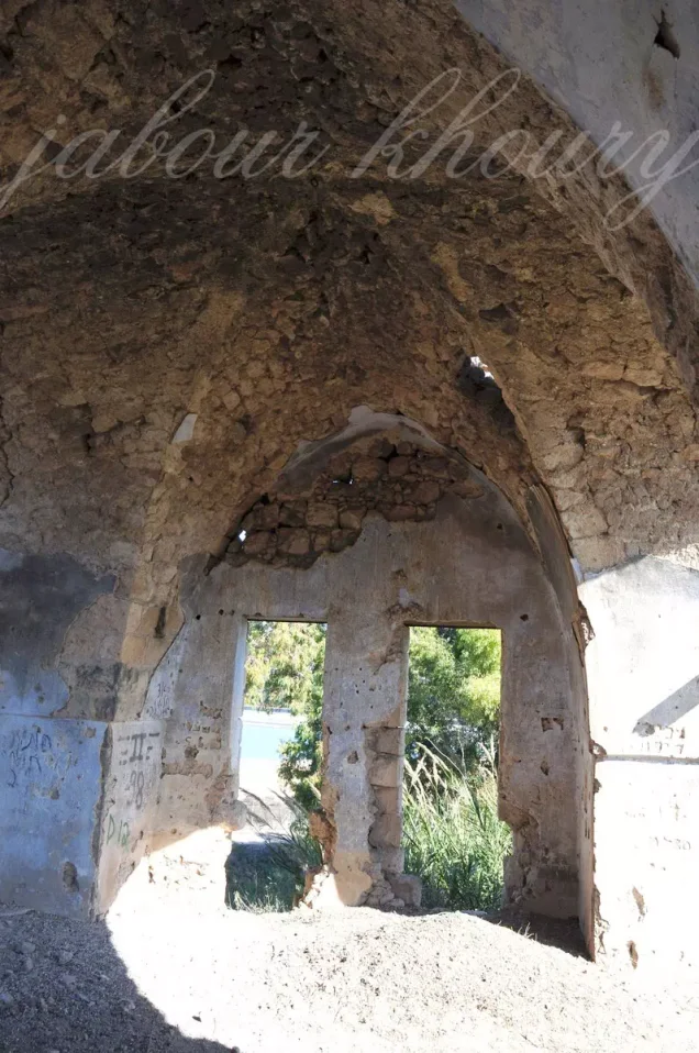
Only one old stone house with an arched doorway remained clearly standing.
The surrounding lands were being cultivated by the settlement of Chulata at the time of the survey.
This description does not constitute direct field verification of conditions in 2026. Field research for All That Remains was conducted between 1987 and 1990, before the book's publication in 1992.
The description should therefore be understood as highly valuable historical field documentation rather than a comprehensive contemporary survey of all former Tulayl lands.
Sources
- PalQuestPalQuest – Tulayl
- PalQuestPalQuest – al-Husayniyya; combined statistics and the March–April 1948 military context
- PalQuestPalQuest – Operation Yiftach
- Palestine RememberedPalestine Remembered – Tulayl, Safad District
- Palestine RememberedPalestine Remembered – Tulayl entry from Walid Khalidi's All That Remains
- Institute for Palestine StudiesInstitute for Palestine Studies – Walid Khalidi, All That Remains
- pcbs.gov.psGovernment of Palestine – Census of Palestine 1922; official Tulayl population of 196
- pcbs.gov.psPalestinian Central Bureau of Statistics – Historical Census Archive
- palqura.comPalestinian Villages Encyclopedia – Tulayl; supplementary documentation on boundaries, Algerian origins, and the disputed occupation date
- Institute for Palestine StudiesInstitute for Palestine Studies – Mustafa 'Abbasi, Safad During the British Mandate Period, 1917–1948
- PalQuestPalQuest – All That Remains: Methodology and Field Research
Photo gallery




Photos from the village's people
Photos sent in by visitors and published after review.
Add a photo of this village
Log in to add photos of this village.
Other villages from Safed

More from the archive



 Download Our Palestine App
The whole archive in the palm of your hand: depopulated villages, the Nakba, the massacres and Al-Aqsa — free, with no ads to erase the story.
Download Our Palestine App
The whole archive in the palm of your hand: depopulated villages, the Nakba, the massacres and Al-Aqsa — free, with no ads to erase the story.



Comments
No comments yet — be the first to write one.
Add your comment
Name and email are optional. Comments appear after review.