
The depopulated village of 'Ammuqa / District of Safed
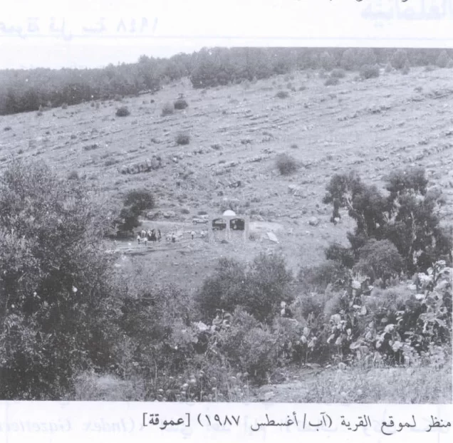
'Ammuqa
About the depopulated village of 'Ammuqa
- District
- Safed
- Date 'Ammuqa was occupied
- 24 May 1948
- Population in 1948
- 162
- Military operation
- Operation Yiftach
- Brigade that carried it out
- Palmach
- Distance from the governorate centre
- 5 (km) North East of Safad
- Elevation above sea level
- 450 m
- Cause of displacement
- Military assault by Zionist troops
- Extent of destruction
- The village has been completely obliterated
- Ethnic cleansing
- 'Ammuqa inhabitants were completely ethnically cleansed.
Hover a dot to read the village name, or click to open its card.
Borders of the depopulated village of 'Ammuqa
'Ammuqa – Depopulated Palestinian Village of the Safad District
'Ammuqa was a depopulated Palestinian village in the Safad District. It stood on the southern slopes of Mount Kan'an approximately 5 kilometers from Safad, at an average elevation of about 450 meters above sea level.
'Ammuqa was one of the district's smaller rural communities and was classified during the Mandate period as a hamlet or farm. The village was locally known for its seven springs, while its entirely Muslim population depended primarily on agriculture and livestock raising.
The village was captured on 24 May 1948 following a Palmach attack carried out in the context of Operation Yiftach. Its inhabitants departed under the pressure of shelling, fear of harm if captured, and fear of being caught in the crossfire between the fighting forces.
Location and Geography
'Ammuqa stood on the southern slopes of Mount Kan'an and faced toward the north and northeast.
It lay approximately 5 kilometers from Safad at an average elevation of about 450 meters above sea level.
Supporting Palestinian documentation places Marus to the north, Qabba'a to the east and northeast, Mughr al-Khayt to the southeast, Biriyya to the south, Taytaba to the southwest, and Dallata to the west and northwest.
The mountainous setting surrounded the village with hills, wadis, springs, and cultivated land.
Name
Walid Khalidi suggests that the name 'Ammuqa may derive from the Syriac word 'ammiqa, meaning “deep” or “low in elevation.”
The village was known by a similar form of the name during the Crusader period.
Because the principal source presents the Syriac derivation as a possibility, it is treated as the most likely explanation rather than as a conclusively established etymology.
Ottoman Period
In 1596, 'Ammuqa belonged to the nahiya of Jira in the liwa' of Safad.
Its estimated population was approximately 391.
The inhabitants paid taxes on wheat, barley, olives, goats, beehives, vineyards, and other forms of agricultural production.
Origins of Some of the Inhabitants
Supporting Palestinian local documentation, drawing on studies of the Safad District, records that a number of the modern inhabitants of 'Ammuqa were of Algerian origin, connected to Algerian migrants who settled in several Safad-area villages during the nineteenth century.
This tradition is linked to Algerian migrants and refugees who reached Ottoman Syria in the period following Algerian resistance to French colonial rule.
The available sources do not provide a demographic breakdown establishing that every inhabitant of 'Ammuqa was of Algerian origin, and some local accounts differ over the precise chronology of migration. The Algerian connection is therefore presented as part of the history of some village families rather than as a categorical description of the entire population.
Built Environment
'Ammuqa was a very small settlement and was classified as a hamlet or farm in the Mandate-era Palestine Index Gazetteer.
The official 1944/45 statistics recorded approximately 30 dunams of built-up land.
The village houses clustered within the mountainous landscape near springs and cultivated fields.
Population and Houses
The inhabitants of 'Ammuqa during the British Mandate were Muslims.
- 1596About 391Historical estimate based on Ottoman records
- 1922114Official Census of Palestine; all inhabitants were Muslims
- 1931108Official census; all inhabitants were Muslims
- 1945140Official statistics; all inhabitants were Palestinian Arab Muslims
- 1948About 162Later demographic estimate, not an official Mandate census
- 1998About 997 refugees and descendantsLater estimate published by Palestine Remembered
The official 1931 census recorded 17 houses in 'Ammuqa.
The estimate of approximately 25 houses in 1948 is a later calculation rather than an official Government of Palestine census figure.
Education and Religious Institutions
Walid Khalidi and PalQuest do not provide clear village-specific documentation of an independent school or a specifically identified mosque in 'Ammuqa before the Nakba.
No particular educational or religious institution is therefore added without stronger Palestinian village-level evidence.
Water Resources
'Ammuqa was locally renowned for its springs.
Walid Khalidi specifically records that the village was known for its seven springs.
Later oral testimony preserves the names of a larger number of local water sources, but the count differs from the principal source. Seven springs is therefore retained as the core documented figure.
These water resources supported domestic use, orchards, and irrigated cultivation.
Economic Life and Agriculture
Agriculture formed the basis of 'Ammuqa's economy.
The villagers devoted most cultivated land to cereals while also growing olives and maintaining orchards supported by local springs.
Livestock raising and the sale of animal products also contributed to the local economy.
In the 1942/43 season approximately 66 dunams were planted with olive trees.
In 1944/45, 1,164 dunams were allocated to cereals and 195 dunams were classified as plantations and irrigable land.
The 66-dunam olive figure is crop-specific and derives from a nearby statistical season; it should not be added again to the official land-use total.
Land Ownership, 1944/45
The total land area of 'Ammuqa was 2,574 dunams.
- Arab2,571 dunums100%
- Jewish0 dunums0%
- Public3 dunums<1%
The official figures balance exactly: 2,571 + 3 = 2,574 dunams.
Palestine Remembered presents the corresponding figures using its own terminology: 2,571 dunams “Palestinian,” 0 dunams “Transferred to Zionists,” and 3 dunams “Communal/Public.”
The phrase “Transferred to Zionists” should be preserved when reproducing that source's classification rather than automatically replacing it with the official “Jewish” category.
Land Use, 1944/45
- Arab
- Public
- Cereals1,164 dunums
- Plantations and irrigable land195 dunums
- Total cultivable/cultivated land1,359 dunums
- Non-cultivable land1,185 dunums
- Built-up land30 dunums
- Total non-cultivable and built-up1,215 dunums
The official table balances exactly: 1,359 dunams of cultivated or cultivable land plus 1,215 dunams of built-up and non-cultivable land equal the total village area of 2,574 dunams.
Archaeology and Khirbas
'Ammuqa and its surroundings contained significant archaeological remains.
Walid Khalidi records an archaeological site containing stone grave markers, together with two nearby khirbas containing fragments of columns and inscribed stones.
Supporting Palestinian documentation identifies these as Khirbat al-Nabra and Khirbat al-Nibratayn.
Local accounts also record scattered building stones, column fragments, and architectural remains at these sites.
The archaeological remains should not all be assigned to a specific period without specialist evidence, and the history of the ancient sites should be distinguished from that of the modern Palestinian village.
Operation Yiftach
Operation Yiftach began on 15 April and ended on 25 May 1948.
The operation was planned under Palmach commander Yigal Allon and carried out to gain control of eastern Galilee, Safad, and the surrounding Palestinian villages.
The Palmach's First Battalion served as the spearhead of the operation at the broader operational level.
The campaign combined direct military attacks, bombardment, and psychological warfare and resulted in the depopulation of numerous Palestinian communities in eastern Galilee.
PalQuest explicitly lists 'Ammuqa among the villages affected by Operation Yiftach.
Occupation and Depopulation of 'Ammuqa
'Ammuqa fell on 24 May 1948, one day before the formal end of Operation Yiftach.
According to Walid Khalidi, the village was attacked by Palmach forces in the context of the operation.
The villagers departed under the pressure of shelling, fear that they would be harmed if captured, and fear of being caught in the crossfire between the fighting forces.
The depopulation should therefore not be characterized as a voluntary departure detached from military conditions; the principal source directly connects it to bombardment, attack, and fear arising from the fighting.
Military Unit
The organization directly identified in Khalidi's village-specific account is the Palmach.
At the operation-wide level, the Palmach's First Battalion spearheaded Operation Yiftach.
The Palestinian Villages Encyclopedia attributes the attack on 'Ammuqa specifically to the First Battalion.
Because Khalidi's own village entry does not identify a battalion number, the most cautious formulation is: Palmach forces; the First Battalion spearheaded Operation Yiftach and is attributed to the 'Ammuqa attack in supporting Palestinian local documentation.
Occupation Chronology
- 15 April 1948
Beginning of Operation Yiftach
The Palmach launched its campaign to gain control of eastern Galilee, Safad, and surrounding villages.
- 10–11 May 1948
Fall of Safad
The capture of the district center intensified fear and displacement in surrounding Palestinian communities.
- May 1948
Expansion of Yiftach forces
Palmach forces continued attacks, shelling, and psychological warfare across eastern Galilee.
- 24 May 1948
Attack on 'Ammuqa
Palmach forces attacked the village as part of Operation Yiftach.
- 24 May 1948
Occupation and depopulation
The villagers left under shelling and fear of capture, harm, and crossfire, and the village fell to Palmach forces.
- 25 May 1948
End of Operation Yiftach
The operation ended one day after the capture of 'Ammuqa.
- After occupation; exact date not documented
Destruction of the village
The houses were subsequently destroyed, leaving only rubble by the time of later field surveys.
Israeli Settlements on Village Lands
The Israeli settlement of Amuka was established in 1980 on 'Ammuqa village land.
It lies approximately one kilometer southeast of the former Palestinian village site.
Walid Khalidi and PalQuest explicitly identify Amuka as the settlement established on 'Ammuqa's lands.
'Ammuqa Today
According to the field description published in Walid Khalidi's All That Remains, nothing remained of the village houses except rubble.
The site had become overgrown with cactuses and eucalyptus, fig, and olive trees.
Much of the surrounding land had become wooded, while residents of the settlement of Amuka cultivated some parts.
PalQuest includes a field photograph of the village site taken by Garo Nalbandian in August 1987.
This description should not be treated as a comprehensive field verification of conditions in 2026. It derives from the historical fieldwork associated with All That Remains, conducted between 1987 and 1990, and therefore documents the site's condition during that survey period.
Sources
- PalQuest – Interactive Encyclopedia of the Palestine Question: 'Ammuqa
- PalQuest – Operation Yiftach
- Palestine Remembered – 'Ammuqa, Safad District
- Palestine Remembered – Walid Khalidi's account of 'Ammuqa
- Palestinian Villages Encyclopedia – 'Ammuqa; supporting Palestinian local documentation
- Government of Palestine – Census of Palestine 1922
- Institute for Palestine Studies – Walid Khalidi, All That Remains
- PalQuest – All That Remains: Methodology and Fieldwork
Photo gallery


Photos from the village's people
Photos sent in by visitors and published after review.
Add a photo of this village
Log in to add photos of this village.
Other villages from Safed

More from the archive



 Download Our Palestine App
The whole archive in the palm of your hand: depopulated villages, the Nakba, the massacres and Al-Aqsa — free, with no ads to erase the story.
Download Our Palestine App
The whole archive in the palm of your hand: depopulated villages, the Nakba, the massacres and Al-Aqsa — free, with no ads to erase the story.



Comments
No comments yet — be the first to write one.
Add your comment
Name and email are optional. Comments appear after review.