
The depopulated village of Al-Wayziyya / District of Safed
Al-Wayziyya
About the depopulated village of Al-Wayziyya
- District
- Safed
- Date Al-Wayziyya was occupied
- 01 May 1948
- Military operation
- Operation Yiftach
- Brigade that carried it out
- Palmach
- Elevation above sea level
- 250 m
Hover a dot to read the village name, or click to open its card.
Borders of the depopulated village of Al-Wayziyya
al-Wayziyya – Depopulated Palestinian Village of Safad
Al-Wayziyya was a depopulated Palestinian village in the Safad Subdistrict, situated northeast of Safad on volcanic terrain sloping toward the al-Hula Plain. Walid Khalidi and PalQuest place the village approximately 8.5 kilometers northeast of Safad at an average elevation of about 250 meters above sea level.
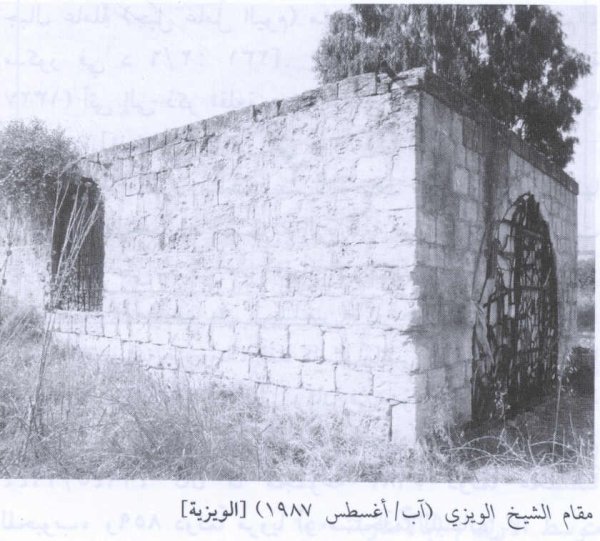
Most of al-Wayziyya's inhabitants were settled or semi-settled Bedouins who depended primarily on livestock raising and limited cultivation. A shrine dedicated to Shaykh al-Wayzi stood about half a kilometer from the village, with a stone quarry immediately to its west.
Basic Information
| Field | Information |
|---|---|
| Name | al-Wayziyya |
| Arabic name | الوَيْزِيَّة |
| Alternative spelling | Weiziya |
| Subdistrict | Safad |
| Region | Eastern Galilee – edge of the al-Hula Plain |
| Distance from Safad | Approximately 8.5 km northeast |
| Elevation | Approximately 250 m above sea level |
| Palestine Grid | 204/267 |
| Total village land | 3,826 dunums |
| Population in 1922 | 30, all Muslims |
| Population in 1931 | No independently recorded figure; al-Wayziyya was statistically associated with Rosh Pinna in the census table |
| 1945 statistics | A total of 100 appears for a combined statistical unit that included al-Wayziyya and several other localities; it should not be treated as a conclusively independent village figure |
| 1948 estimate | 116 – later estimate, not an official census |
| Occupation and depopulation | April or early May 1948; 1 May is widely cited by Palestinian secondary sources, while Khalidi does not establish a precise day |
| Military operation | Operation Yiftach |
| Military unit | Palestine Remembered attributes the attack to the Palmach's First Battalion; Khalidi does not independently identify the village-specific assault unit |
| Cause of depopulation | Palestine Remembered: direct military assault; Khalidi presents a broader context of military advance and flight in anticipation of attack |
| Israeli settlements on village lands | None according to Walid Khalidi |
Name and Etymology
The village name is associated with Shaykh al-Wayzi, whose shrine and grave stood approximately half a kilometer from the village site. Palestinian sources identify the shrine as one of the locality's principal landmarks and, ultimately, as the only substantial village landmark to survive the destruction.
Location and Geography
Al-Wayziyya stood on volcanic terrain that sloped northward toward the al-Hula Plain. The surrounding landscape contained steep slopes and watercourses draining toward the Jordan Valley.
Wadi al-Mushayrifa passed roughly a quarter of a kilometer south, southeast, and east of the village. Its southern section was locally known as Wadi Abu al-Hayyat, while Wadi al-Hajj Ayyub lay toward the northeast.
A secondary road connected al-Wayziyya with a main highway leading toward Safad and Tiberias.
Neighboring Villages
Al-Husayniyya lay to the north; Kirad al-Ghannama and Kirad al-Baqqara to the northeast; Yarda to the east; Khirbat al-Muntar to the south; Farr'im to the southwest; Qabba'a to the west; and Marus to the northwest.
Shaykh al-Wayzi Shrine and Quarry
The shrine of Shaykh al-Wayzi stood approximately half a kilometer from the village. Immediately west of it was a stone quarry. The shrine became the principal surviving landmark of al-Wayziyya after the destruction of the village.
Population
Al-Wayziyya's population figures require particular care because the village was statistically grouped with other localities in parts of the Mandate-period records.
| Year | Population | Status of Figure |
|---|---|---|
| 1922 | 30 | Independent official census figure; all inhabitants were recorded as Muslims |
| 1931 | No separate figure available | The census table lists Weiziya without an independent total immediately after Rosh Pinna; Palestinian reference works state that its population was included with Rosh Pinna |
| 1945 | 100 | Figure for a combined statistical unit that included al-Wayziyya together with Mazari' al-Daraja, Dardara, Dureijat, 'Ayn al-Tina, and Jalabina; it is not treated here as a confirmed independent village total |
| 1948 | 116 | Later estimate, not an official census |
| 1998 | 712 | Later estimate of refugees and descendants, not an official census |
The current PalQuest page displays 100 under the year 1931, but this conflicts with the official 1931 census table, which does not give al-Wayziyya an independent figure. This article therefore does not use 100 as the village's 1931 population.
Number of Houses
No independently documented number of houses for al-Wayziyya is available from the 1931 census because of its statistical grouping, and no reliable independent official house total for 1948 was located. A house count should therefore not be inferred from population estimates.
Land Ownership, 1944/45
- Palestinian0 dunums0%
- Transferred to Zionists3,673 dunums96%
- Public153 dunums4%
The original Government of Palestine categories were Arab, Jewish, and Public. The official table classified 3,673 dunums under Jewish ownership and 153 dunums as public land, with no land recorded under the Arab ownership column. In accordance with the terminology used in this project, the second category is rendered here as “Transferred to Zionists.”
The ownership figures balance exactly: 3,673 + 153 = 3,826 dunums.
Land Use, 1944/45
- Transferred to Zionists
- Public
- Cereals3,611 dunums
- Plantations and irrigable land62 dunums
- Non-cultivable land153 dunums
The land-use figures balance exactly: 3,611 + 62 + 153 = 3,826 dunums.
The PalQuest table does not provide a separate built-up-area figure, so no unsupported built-up figure is added.
Economy
Most villagers were Bedouins who depended on livestock raising and limited agriculture. Cereal cultivation dominated the recorded agricultural land, with a smaller area devoted to plantations or irrigable cultivation.
A stone quarry immediately west of the Shaykh al-Wayzi shrine was another economic feature of the village area.
Education and Services
Neither Khalidi nor the principal Palestinian sources consulted provide documentation of a school in al-Wayziyya. A Palestinian village reference project states that the inhabitants had few or no local public services. No school, clinic, or administrative facility is therefore asserted without further evidence.
Operation Yiftach
Al-Wayziyya was depopulated within the context of Operation Yiftach, carried out by Palmach forces in eastern Galilee between 15 April and 25 May 1948 under the broader framework of Plan Dalet.
The Palmach's First Battalion spearheaded Operation Yiftach as a whole, whose objectives included securing Safad and the surrounding villages and controlling eastern Galilee before the end of the British Mandate.
Occupation and Depopulation
The exact day on which al-Wayziyya fell is not firmly established across the sources.
Palestine Remembered and a Palestinian village encyclopedia give 1 May 1948 and attribute the action to the Palmach's First Battalion. A Palestinian register of depopulated localities gives 30 April while also marking May 1948 as an estimated date.
Walid Khalidi's account is more cautious. As reproduced by PalQuest, it states that al-Wayziyya was occupied in April or May 1948 and probably fell before the final assault on Safad on 10 May, during the advance into villages surrounding the city.
The most defensible formulation is therefore that al-Wayziyya was occupied in late April or early May 1948 during Operation Yiftach. The frequently cited date of 1 May should be retained as an attributed date rather than presented as conclusively established by Khalidi.
Military Unit
Palestine Remembered identifies the Palmach's First Battalion as the attacking unit. The First Battalion did indeed spearhead Operation Yiftach.
Khalidi's village-specific narrative, however, does not independently name the unit that entered al-Wayziyya. Participation in the wider operation should therefore not be converted into definitive proof of a separate First Battalion assault on the village without qualification.
Cause of Depopulation
Palestine Remembered classifies the cause as a direct military assault.
Khalidi provides a more cautious context: villages to the north had begun to empty in late April in anticipation of a Haganah attack, while nearby Mughr al-Khayt was struck by mortar fire on 2 May. He considers it likely that al-Wayziyya fell during the military advance against villages surrounding Safad before the final assault on the city.
It can therefore be established that al-Wayziyya was depopulated amid Operation Yiftach and escalating military pressure around Safad, but Khalidi's narrative alone does not determine whether all residents fled after a direct assault on their homes or whether some left before the forces entered because of fear generated by the surrounding attacks.
Destruction
Al-Wayziyya was subsequently destroyed. Khalidi does not provide a precise date for the demolition of its buildings, so the occupation date should not automatically be treated as the destruction date.
In his later field description, the shrine of Shaykh al-Wayzi was the only substantial village landmark still standing, while rubble from destroyed houses was scattered across the site.
Ethnic Cleansing in Source Classification
Palestine Remembered classifies al-Wayziyya using the term “complete ethnic cleansing.” The directly documented facts are that the village was emptied of its Palestinian population in the context of Operation Yiftach during spring 1948, the inhabitants did not return to permanent residence there, and the village buildings were later destroyed except for the shrine of Shaykh al-Wayzi.
Occupation Chronology
| Date | Event |
|---|---|
| 15 April 1948 | Operation Yiftach began in eastern Galilee. |
| Late April 1948 | Residents of villages north of the area began leaving in anticipation of Haganah attacks as military pressure around Safad intensified. |
| 30 April–1 May 1948 | Period given by several Palestinian sources for the fall of al-Wayziyya; Palestine Remembered uses 1 May, while another Palestinian register gives 30 April and marks May as approximate. |
| 2 May 1948 | Nearby Mughr al-Khayt was struck by mortar fire, illustrating the intensity of operations in the surrounding area. |
| Before 10 May 1948 | Khalidi considers it likely that al-Wayziyya had fallen during the advance on villages surrounding Safad. |
| 10–11 May 1948 | The final assault on Safad took place and the city fell during Operation Yiftach. |
| After occupation | Most village buildings were destroyed; the precise demolition date is not documented. |
Israeli Settlements on al-Wayziyya's Lands
According to Walid Khalidi and PalQuest, no Israeli settlement was established on al-Wayziyya's village lands.
Mahanayim had been established in 1939, before the Nakba, approximately 1.5 kilometers southeast of the village site. It should therefore not be described as a post-1948 settlement established on the ruins of al-Wayziyya.
A later Palestinian village reference states that portions of al-Wayziyya's land were incorporated into Mahanayim. This concerns subsequent land use and should be distinguished from Khalidi's more specific statement about the location on which the settlement itself was established.
al-Wayziyya Today
According to the field description used by Walid Khalidi, the shrine of Shaykh al-Wayzi was the only substantial village landmark still standing. Rubble from the destroyed houses was scattered throughout the site.
Grass, Christ's-thorn, eucalyptus, and pine trees grew in the surrounding area, while much of the land was being used as pasture.
PalQuest identifies a photograph of the Shaykh al-Wayzi shrine as dating to August 1987. Khalidi's description likewise derives from fieldwork conducted before the publication of All That Remains in 1992. It should therefore be treated as a documented historical description rather than a comprehensive direct field verification of the site's condition in 2026.
Sources
- PalQuest – Interactive Encyclopedia of the Palestine Question: al-Wayziyya
- PalQuest – Operation Yiftach
- Palestine Remembered – al-Wayziyya, Safad Subdistrict
- Palestine Remembered – al-Wayziyya entry from Walid Khalidi's All That Remains
- Palestinian Villages Encyclopedia – al-Wayziyya
- Palestine Land Society – Atlas of Palestine 1917–1966
- Government of Palestine – Census of Palestine 1931
- Palestine Land Society – Register of Depopulated Localities in Palestine
Photos from the village's people
Photos sent in by visitors and published after review.
Add a photo of this village
Log in to add photos of this village.
Other villages from Safed


More from the archive



 Download Our Palestine App
The whole archive in the palm of your hand: depopulated villages, the Nakba, the massacres and Al-Aqsa — free, with no ads to erase the story.
Download Our Palestine App
The whole archive in the palm of your hand: depopulated villages, the Nakba, the massacres and Al-Aqsa — free, with no ads to erase the story.



Comments
No comments yet — be the first to write one.
Add your comment
Name and email are optional. Comments appear after review.