
The depopulated village of Al-'Abisiyya (Safed) / District of Safed
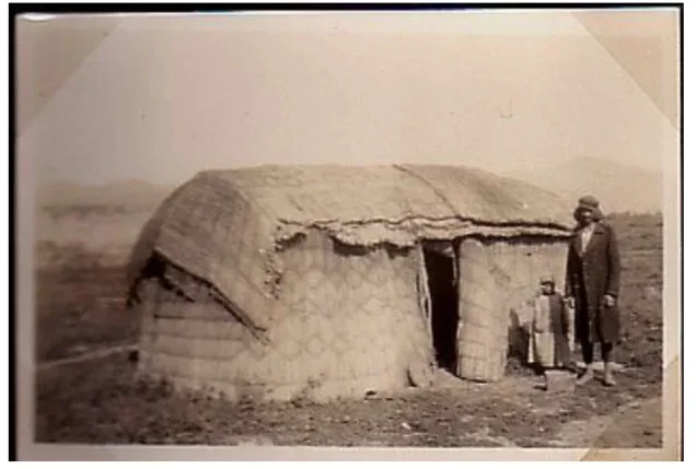
Al-'Abisiyya (Safed)
About the depopulated village of Al-'Abisiyya (Safed)
- District
- Safed
- Date Al-'Abisiyya (Safed) was occupied
- 29 May 1948
- Population in 1948
- 830
- Military operation
- Operation Yiftach
- Brigade that carried it out
- Palmach
- Distance from the governorate centre
- 28.5 (km) North East of Safad
- Elevation above sea level
- 75 m
- Extent of destruction
- The village has been completely obliterated.
- Ethnic cleansing
- al-'Abisiyya was ethnically cleansed as a result of a psychological warfare on the 25th of May 1948.
- Settlements built on the land of Al-'Abisiyya (Safed) before 1948
- Kfar Szold
Hover a dot to read the village name, or click to open its card.
Borders of the depopulated village of Al-'Abisiyya (Safed)
al-'Abisiyya – Safad Subdistrict
Al-'Abisiyya was a depopulated Palestinian village in the Safad subdistrict, situated in the northeastern part of the al-Hula Plain near the Palestine–Syria frontier. It lay approximately 28.5 km northeast of Safad at an average elevation of about 75 meters. The village stood close to the Banyas River, whose abundant water resources were central to local agriculture.
The official 1931 Census of Palestine recorded 609 inhabitants, all Muslims, living in 123 occupied houses. Government population statistics for April 1945 recorded 830 Muslims in al-'Abisiyya itself. The villagers were displaced in late May 1948 in the context of Operation Yiftach, although the exact date on which military forces physically entered the village site cannot be established with certainty from the principal sources.
Location of al-'Abisiyya
Al-'Abisiyya stood on level ground in the northeastern sector of the Hula Plain, close to the Syrian frontier. Secondary roads connected it with neighboring villages. PalQuest places the village 28.5 km from Safad at an average elevation of 75 meters.
The Banyas River ran alongside village lands and supplied water for irrigation. The inhabitants also obtained drinking water from nearby springs that flowed into the river.
Palestinian sources place Qaytiyya west and northwest of al-'Abisiyya, al-Mansura to the north, and al-Dawwara to the south, while Syrian lands lay to the east and northeast. A Palestinian local source places al-Muftakhira to the southeast. The Hula basin and lake lay south of the area.
The Name al-'Abisiyya
Walid Khalidi and PalQuest use the form al-'Abisiyya. Other Palestinian sources preserve variants including al-'Absiyya, al-Ghabisiyya, and occasionally al-'Abbasiyya. A Palestinian village-history source, citing Mustafa Murad al-Dabbagh, also reports that the locality was known during part of the Ottoman period as Khiyam 'Abs.
The principal sources reviewed do not provide a securely documented explanation for the origin of the name, so no definite tribal or personal etymology has been assigned here.
al-'Abisiyya in the Late Nineteenth Century
The Survey of Western Palestine described al-'Abisiyya in the late nineteenth century as a small settlement of adobe houses with approximately seventy inhabitants. The villagers cultivated the surrounding land and benefited from abundant water, particularly the Banyas River, for irrigation.
Most houses were clustered closely together, although construction became more dispersed on the eastern side as the village expanded during the British Mandate period.
Population of al-'Abisiyya
- Late 19th centuryAbout 70Approximation recorded by the Survey of Western Palestine; not an official census
- 1931609Official Census of Palestine; all enumerated inhabitants were Muslims
- 1945830Muslim population of al-'Abisiyya itself in the official population table based on Village Statistics, April 1945
- 1944/45 – wider statistical unit1,5101,220 Arabs and 290 Jews; the figure includes al-'Abisiyya, Kefar Szold, al-Azaziyat, Ayn Fit, and Khirbat al-Summan and is not the population of al-'Abisiyya alone
The distinction between 830 and 1,510 is essential. The former is the official 1945 Muslim population figure for al-'Abisiyya itself. The latter is the total for a broader statistical unit that combined the village with several other localities.
The principal sources reviewed do not provide a sufficiently reliable later estimate for al-'Abisiyya's population in 1948 or for its refugee population and descendants in 1998. No unsupported figures have therefore been added.
Number of Houses
| Year | Occupied houses | Nature of figure |
|---|---|---|
| 1931 | 123 | Official Census of Palestine |
The 1931 census officially recorded 123 occupied houses in al-'Abisiyya. The reviewed core sources do not provide a sufficiently verified house total for 1948.
Land Ownership
Palestine Remembered presents the land-ownership figures using the following terminology. PalQuest, however, explicitly notes that the 1944/45 statistical unit also included Kefar Szold, al-Azaziyat, Ayn Fit, and Khirbat al-Summan.
- Palestinian13,671 dunums89%
- Transferred to Zionists1,257 dunums8%
- Communal/Public501 dunums3%
PalQuest reproduces the official categories Arab, Jewish, and Public, giving the same figures: 13,671 dunums Arab, 1,257 dunums Jewish, and 501 dunums Public.
Because the official statistical unit combined several localities, the total of 15,429 dunums should be used with an explicit qualification rather than automatically treated as an independently tabulated cadastral area belonging solely to al-'Abisiyya.
Land Use in 1944/45
- Arab
- Jewish
- Public
- Citrus and bananas4 dunums
- Cereals3,339 dunums
- Plantations and irrigable land6,621 dunums
- Built-up land57 dunums
- Non-cultivable land5,408 dunums
This corrected table resolves an important presentation problem in Palestine Remembered, where 4,931 dunums of non-arable land appear under the Palestinian column. PalQuest's official breakdown shows that the figure consists of 4,430 Arab dunums plus 501 dunums of Public land. The entire 4,931 dunums should therefore not be classified as privately Palestinian-held land.
Economic Life in al-'Abisiyya
Agriculture was the principal source of livelihood. The village benefited from the plentiful water resources of the Banyas River and nearby springs, allowing substantial irrigated cultivation.
The inhabitants cultivated fruit and vegetables, including oranges, particularly south and southwest of the village and on land beyond the river. Within the 1944/45 statistical unit, Arab cultivation included 2,830 dunums of cereals and 6,390 dunums of plantations and irrigable land, in addition to four dunums devoted to citrus and bananas.
Water
The Banyas River was the most important water source associated with al-'Abisiyya and was used for irrigation. Drinking water was also obtained from nearby springs flowing into the river.
Later local oral documentation refers to a spring remembered as Ayn al-Sakhina and to other unnamed springs closer to the village houses. These names derive primarily from community memory and should be distinguished from the better-documented geographical information in the principal historical sources.
Education
Neither Khalidi's village entry nor PalQuest records a formal school in al-'Abisiyya. A Palestinian local history based partly on oral testimony from a former villager states that the village did not have a regular school and that some boys instead received elementary instruction in reading, writing, arithmetic, and Qur'anic studies from local religious teachers.
This is local and oral-history evidence rather than an official Department of Education record, and it cannot be used to assign a formal school founding date or enrollment figure.
Religious Life
All 609 inhabitants enumerated in the official 1931 census were Muslims. Khalidi's principal village entry does not identify a completed mosque in the village.
Later Palestinian oral documentation states that residents prayed in a large house and had begun constructing a mosque before the Nakba, but that the building was not completed before the villagers were displaced in 1948. The same local source mentions a shrine associated with Shaykh Hudayba. The principal sources reviewed do not independently verify or date that shrine.
Archaeological and Nearby Sites
Khalidi records the nearby sites of Tall al-Sakhina, Tall al-Shari'a, and al-Shaykh Ghannam. Palestinian local documentation additionally reports visible ruins and pottery fragments at Tall al-Shari'a.
The sources reviewed do not provide a detailed archaeological investigation sufficient to assign these remains to a specific historical period with certainty.
Operation Yiftach
Operation Yiftach lasted from 15 April to 25 May 1948 in eastern Galilee. It was organized by Palmach commander Yigal Allon and carried out principally by Palmach forces. The Palmach's First Battalion served as the spearhead of the operation as a whole.
The campaign combined direct military attacks with psychological warfare. PalQuest records an organized rumor campaign between 10 and 15 May designed to frighten Palestinian residents of eastern Galilee and the Hula region and encourage them to leave.
Al-'Abisiyya was one of the villages affected by Operation Yiftach. Khalidi's village-specific entry, however, does not provide a detailed independent description of a particular assault on the village or name the specific battalion that physically entered it.
Occupation and Depopulation of al-'Abisiyya
Walid Khalidi, citing an Israeli military intelligence report, states that the inhabitants of al-'Abisiyya left on 25 May 1948 and that psychological warfare conducted in conjunction with Operation Yiftach was a major factor in their departure.
Khalidi also relays Israeli historian Benny Morris's view that the village may have been subjected to a direct military assault, but the village entry provides no independent operational details that establish the timing or course of such an attack.
Palestine Remembered lists 29 May 1948 in its page header as the village's occupation date. Yet its detailed narrative reproduces Khalidi's account of the inhabitants leaving on 25 May, while PalQuest dates the end of Operation Yiftach itself to 25 May.
The strongest documented conclusion is therefore that al-'Abisiyya's inhabitants departed on 25 May 1948 in the context of psychological warfare and Operation Yiftach, with a direct assault remaining possible. The exact date on which military forces physically occupied the already depopulated site cannot be established with sufficient confidence from the core sources.
Occupation Chronology
- 15 April 1948
Beginning of Operation Yiftach
The broader Palmach campaign to take control of eastern Galilee began.
- 10–15 May 1948
Psychological-warfare campaign
An organized rumor campaign sought to frighten Palestinian residents of eastern Galilee and the Hula region into leaving.
- 18 May 1948
Request for al-'Abisiyya lands
Members of Sde Nechemya requested that 1,700 dunums of al-'Abisiyya's lands be allocated to their settlement. The request is documented but does not by itself prove that the transfer was implemented.
- 25 May 1948
Departure of the villagers
According to an Israeli military intelligence report cited by Khalidi, the villagers left under the impact of psychological warfare. A direct military attack may also have occurred.
- 25 May 1948
End of Operation Yiftach
PalQuest dates the conclusion of Operation Yiftach to this day.
- 29 May 1948
Different occupation date listed by Palestine Remembered
This date appears in the page header, but the detailed village narrative does not document a distinct military event on that day; it should therefore not be treated as a fully established final occupation date.
Military Unit
Al-'Abisiyya is associated with Operation Yiftach, which was conducted by Palmach forces. The Palmach's First Battalion was the spearhead of Yiftach as an overall operation.
Palestine Remembered identifies the First Battalion as the attacking unit at al-'Abisiyya. Khalidi's village-specific narrative, however, does not independently name the battalion that entered the village and instead discusses psychological warfare together with the possibility of a direct assault. The more cautious formulation is therefore that al-'Abisiyya was depopulated in the context of Operation Yiftach by Palmach forces, without treating the First Battalion's village-specific role as independently established.
Early Interest in al-'Abisiyya's Lands
On 18 May 1948, several days before the villagers' departure, members of the neighboring settlement of Sde Nechemya wrote to the head of the Agricultural Center asking to be allocated 1,700 dunums of al-'Abisiyya's lands.
As reproduced by Khalidi, this document demonstrates early interest in the village's lands even before its depopulation was complete. The request itself, however, does not prove that the entire requested area was subsequently transferred, and it should not be converted into a definitive ownership claim without further documentation.
Israeli Settlements on or near al-'Abisiyya's Lands
Three Jewish settlements had been established very close to al-'Abisiyya before 1948, but their relationship to village lands differed substantially.
| Settlement | Established | Relationship to al-'Abisiyya |
|---|---|---|
| Kefar Szold | 1942 | Established on land traditionally regarded as belonging to al-'Abisiyya, east of the village site |
| 'Amir | 1939 | Very close to al-'Abisiyya but established on lands belonging to al-Dawwara |
| Sde Nechemya | 1940 | Very close to al-'Abisiyya but established on lands belonging to al-Dawwara |
'Amir and Sde Nechemya should therefore not be described as settlements originally established on al-'Abisiyya's lands merely because of their geographical proximity to the village.
al-'Abisiyya Today
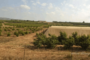
In the field description published by Walid Khalidi in All That Remains, no visible trace of the village buildings remained when the site was surveyed. Grass, wild vegetation, shrubs, and a few scattered trees covered the site, while surrounding lands were cultivated by residents of Kefar Szold.
This is not a direct field verification of conditions in 2026. The published methodology of All That Remains states that research teams visited village sites between 1987 and 1990, before the English edition was published in 1992. The description should therefore be understood as a documented record of the site in the late 1980s rather than a contemporary survey.
Sources
- PalQuest – al-'Abisiyya
- PalQuest – Operation Yiftach
- PalQuest – Methodology of All That Remains
- Palestine Remembered – al-'Abisiyya, Safad District
- Walid Khalidi – All That Remains
- E. Mills – Census of Palestine 1931: Population of Villages, Towns and Administrative Areas
- Government of Palestine – Village Statistics, April 1945, as reproduced by the United Nations Conciliation Commission for Palestine
- Palestinian Villages Encyclopedia – al-'Abisiyya, used specifically for locally sourced oral-history material on education, religious life, and local place names
Photo gallery


Photos from the village's people
Photos sent in by visitors and published after review.
Add a photo of this village
Log in to add photos of this village.
Other villages from Safed
More from the archive



 Download Our Palestine App
The whole archive in the palm of your hand: depopulated villages, the Nakba, the massacres and Al-Aqsa — free, with no ads to erase the story.
Download Our Palestine App
The whole archive in the palm of your hand: depopulated villages, the Nakba, the massacres and Al-Aqsa — free, with no ads to erase the story.



Comments
No comments yet — be the first to write one.
Add your comment
Name and email are optional. Comments appear after review.