
The depopulated village of Al-Buwayziyya / District of Safed

Al-Buwayziyya
About the depopulated village of Al-Buwayziyya
- District
- Safed
- Date Al-Buwayziyya was occupied
- 11 May 1948
- Population in 1948
- 590
- Military operation
- Operation Yiftach
- Brigade that carried it out
- Palmach
- Distance from the governorate centre
- 22 (km) North East of Safad
- Elevation above sea level
- 100 m
- Cause of displacement
- Influence of fall of, or exoduce from, neighboring town
- Extent of destruction
- The village has been completely destroyed, and only house rubble left behind.
- Ethnic cleansing
- al-Buwayziyya inhabitants were completely ethnically cleansed.
Hover a dot to read the village name, or click to open its card.
Borders of the depopulated village of Al-Buwayziyya
al-Buwayziyya (al-Buwayziyya and Mays) – Safad Subdistrict
Al-Buwayziyya was a depopulated Palestinian village in the Safad subdistrict. Many Palestinian sources refer to it as “al-Buwayziyya and Mays” because the small nearby settlement of Mays was administratively and statistically associated with it in the later Mandate period.
The village stood on the western edge of the al-Hula Plain at the foot of the rocky slopes of Mount 'Amil, approximately 22 km northeast of Safad and at an average elevation of about 100 meters according to PalQuest.
Al-Buwayziyya lay on the western side of the main Tiberias–al-Mutilla road. Agriculture formed the principal livelihood, with citrus, fruit orchards, cereals, and vegetables among the important crops.
The official 1931 census recorded 318 inhabitants. In 1944/45, the recorded population was 510, but PalQuest explicitly notes that this figure includes Mays. The same qualification applies to the registered land area of 14,620 dunums.
Zionist forces took al-Buwayziyya on 11 May 1948 in the context of Operation Yiftach. Khalidi links the villagers' departure to the fall of neighboring al-Khalisa and to the broader military and psychological impact of the fall of Safad.
Location
Al-Buwayziyya stood at the western edge of the al-Hula Plain where the flat valley met the rocky lower slopes of Mount 'Amil.
The village extended along the western side of the highway connecting Tiberias with al-Mutilla in the far north of Palestine. Later expansion occurred especially toward the north near the junction of a local road with the main highway.
A small wadi descended from the western hills through the area toward the al-Hula Plain.
Al-Buwayziyya and Mays
Palestinian sources frequently pair the names al-Buwayziyya and Mays.
Later community documentation describes Mays as a small settlement slightly west and northwest of al-Buwayziyya, close to the Lebanese frontier and located within the broader lands associated with al-Buwayziyya.
Mays does not appear as a separate locality in the 1922 census. Later Palestinian sources indicate that it was merged statistically with al-Buwayziyya, while PalQuest explicitly states that the 1944/45 population and land figures include Mays.
The 1945 figures therefore should not be treated as representing al-Buwayziyya alone without qualification.
Neighboring Villages and Areas
| Direction | Village / Area |
|---|---|
| North | al-Khalisa |
| Northeast | al-Na'ima |
| East | al-Zawiya and the al-Hula Plain |
| South | Jahula |
| Southwest | Qadas |
| West | Lebanese lands |
| Northwest | Mays and the frontier area; local documentation also places al-Manara in the wider surroundings |
The Palestinian Encyclopedia also mentions Hunin among the surrounding village lands. Original cadastral maps remain the best evidence for exact boundary lines.
The Population and the Name
The inhabitants were known as Arab al-Buwayziyya and are associated in Palestinian reference works with the Ghawarna communities of the al-Hula region.
The 1922 Census of Palestine listed Buaizia under “Tribal Areas.” This administrative classification should not automatically be read as meaning that the entire community remained nomadic: by the Mandate period al-Buwayziyya was a settled village with houses, a school, and substantial cultivated lands.
Local Palestinian documentation relates the village name to Arab al-Buwayziyya themselves.
Population
- 1922276Official Census of Palestine; all Muslims, recorded as Buaizia
- 1931318Official census; all Muslims, living in 75 houses
- 1944/45510Official statistics; PalQuest explicitly notes that the figure includes Mays
- 1948592Later Palestine Remembered estimate; not an official census
- 19983,633 refugees and descendantsLater demographic estimate published by Palestine Remembered
Number of Houses
- 193175Official Census of Palestine
- 1948139Later Palestine Remembered estimate; not an official census figure
Land Ownership in 1944/45: al-Buwayziyya and Mays
The combined land unit of al-Buwayziyya and Mays totaled 14,620 dunums.
Using Palestine Remembered's simplified terminology:
- Palestinian13,226 dunums90%
- Transferred to Zionists503 dunums3%
- Communal/Public891 dunums6%
The official categories record the same figures as 13,226 Arab dunums, 503 Jewish dunums, and 891 Public dunums.
These figures include Mays and should not be presented as the land area of al-Buwayziyya alone without qualification.
Land Use in 1944/45
- Arab
- Jewish
- Public
- Cereals3,113 dunums
- Plantations and irrigable land56 dunums
- Built-up land17 dunums
- Non-cultivable land11,434 dunums
The land-use totals balance exactly with the official ownership figures.
Palestine Remembered's simplified display can give the impression that 11,274 dunums of non-arable land were entirely Palestinian. The official breakdown shows that this figure combines 10,383 Arab dunums with 891 Public dunums; the full non-cultivable category also included 160 Jewish dunums.
Economic Life
Agriculture was the principal livelihood of al-Buwayziyya's inhabitants, alongside livestock raising.
Citrus and other fruit were especially important, while villagers also cultivated cereals and vegetables.
In 1944/45, 2,770 Arab dunums were allocated to cereals and 56 dunums were classified as plantations or irrigable land.
The location on the edge of the fertile al-Hula Plain and the availability of water supported both agricultural and pastoral activity.
Water Sources
Several springs supplied al-Buwayziyya with water.
The Palestinian Encyclopedia identifies 'Ayn al-Bara north of the village and 'Ayn al-'Amudiyya on its southern outskirts, stating that the latter supplied the inhabitants with drinking water.
A small wadi also descended from the western hills into the al-Hula lands.
Education
A boys' elementary school opened in al-Buwayziyya in 1937, with some Palestinian references identifying the opening as the beginning of the 1937–38 school year.
The core village source does not provide a securely documented enrollment figure, so none has been added.
Religious Life
The inhabitants recorded in the Mandate censuses were Muslims.
Khalidi's core village entry does not clearly document a specific mosque or named shrine in al-Buwayziyya, and no such structure has therefore been added without supporting evidence.
Al-Buwayziyya before the Nakba
Its position on the western edge of the al-Hula Plain, close to the Lebanese frontier and the Tiberias–al-Mutilla highway, placed al-Buwayziyya within the principal operational zone of Operation Yiftach in the spring of 1948.
Operation Yiftach began on 15 April and aimed to take control of eastern Galilee before the end of the British Mandate. The Palmach's First Battalion served as its spearhead.
The offensive combined direct military attacks with psychological warfare. Between 10 and 15 May, a rumor campaign was used to accelerate the departure of Palestinian communities in the al-Hula and eastern Galilee region.
The Falls of al-Khalisa and Safad
Al-Khalisa lay approximately 5 km north of al-Buwayziyya.
Khalidi records that al-Buwayziyya's inhabitants left when they learned that al-Khalisa had fallen. Residents of al-Khalisa had sought an arrangement that would allow them to remain, but the Haganah rejected their request.
The fall of Safad during the same period, on 11 May, further weakened morale across the villages of the subdistrict and accelerated displacement.
Occupation and Depopulation of al-Buwayziyya
Zionist forces took al-Buwayziyya on 11 May 1948 during Operation Yiftach.
Khalidi's account does not describe a prolonged battle inside the village itself. Instead, it links the villagers' departure primarily to the fall of neighboring al-Khalisa, fear of a direct attack, and the broader military and psychological impact of the fall of Safad.
The most accurate formulation is therefore that al-Buwayziyya was depopulated under the impact of the advancing Operation Yiftach forces, the fall of nearby Palestinian localities, and the immediate threat of attack, rather than through an independently documented village battle.
Military Unit
Palestine Remembered identifies the attacking formation as the Palmach's First Battalion.
This fits the broader military context documented by PalQuest, which describes the First Battalion as the spearhead of Operation Yiftach and records its intensive activity around Safad and the al-Hula region in May 1948.
Khalidi's village-specific text does not identify a company or platoon that entered al-Buwayziyya, so the unit should not be narrowed beyond the battalion level without additional evidence.
Occupation Chronology
- 15 April 1948
Beginning of Operation Yiftach
Palmach operations began to take control of eastern Galilee and the Safad–al-Hula region before the end of the Mandate.
- Late April – early May 1948
Escalation of military and psychological pressure
Villages around Safad and across eastern Galilee were subjected to raids, military pressure, and psychological warfare.
- 9 May 1948
Attack on 'Akbara
Units of the Palmach's First Battalion attacked 'Akbara as part of efforts to increase pressure on Safad and its surrounding Palestinian population.
- 10–11 May 1948
Final assault on Safad
The city fell after the final assault, prompting further flight from villages across the subdistrict.
- By 11 May 1948
Fall of al-Khalisa and its impact
Khalidi records that the inhabitants of al-Buwayziyya left after hearing that nearby al-Khalisa had fallen.
- 11 May 1948
Occupation of al-Buwayziyya
Zionist forces took the village in the context of Operation Yiftach.
- After 11 May 1948
Northward advance
Yiftach units were ordered to move north and block routes through which Lebanese and Syrian forces might enter Palestine.
- 25 May 1948
End of Operation Yiftach
The operation ended after Zionist forces had taken control of eastern Galilee and depopulated many Palestinian communities.
- Later; exact date not established
Destruction of the village
Most of the village's built environment was destroyed; the core source does not provide one exact demolition date.
Refugees from al-Buwayziyya
Palestine Remembered estimates the population in 1948 at approximately 592. This is a later demographic estimate rather than an official Mandate census figure.
The same source estimates that refugees from the village and their descendants numbered approximately 3,633 in 1998.
Later oral-history interviews, photographs, and community documentation preserve additional information about families from al-Buwayziyya and Mays, but these do not constitute an official comprehensive refugee census.
Israeli Settlements on al-Buwayziyya Village Lands
Walid Khalidi and PalQuest state that no new Israeli settlement was established directly on al-Buwayziyya's village lands as a separate settlement.
The Palestine Remembered version of Khalidi's entry also states that parts of the village lands were later incorporated into the nearby settlement of Mahanayim, which had already been established in 1939.
This distinction is important: incorporation of former village lands into a pre-existing neighboring settlement is not the same as establishing a new settlement on the village site.
al-Buwayziyya Today
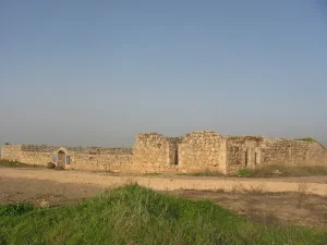
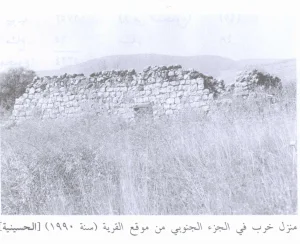
In Walid Khalidi's field description, the site contained the remains of destroyed houses, several walls and terraces, and the intact concrete roof of one house.
The flat surrounding lands were being cultivated, while the more hilly areas were being used as pasture.
This description is not direct field verification of conditions in 2026. It derives from the field research conducted for All That Remains between 1987 and 1990 before the book's publication in 1992.
Palestine Remembered also contains later photographs of the site, including documentation from 2005. These materials help trace changes since the original survey but do not constitute a comprehensive contemporary field survey of all former lands of al-Buwayziyya and Mays.
Sources
- PalQuestPalQuest – al-Buwayziyya
- PalQuestPalQuest – Operation Yiftach and military operations in eastern Galilee
- Palestine RememberedPalestine Remembered – al-Buwayziyya and Mays, Safad District
- Palestine RememberedPalestine Remembered – al-Buwayziyya entry from Walid Khalidi's All That Remains
- Institute for Palestine StudiesInstitute for Palestine Studies – Walid Khalidi, All That Remains
- users.cecs.anu.edu.auGovernment of Palestine – Census of Palestine 1922
- palestinapedia.psPalestinian Encyclopedia – al-Buwayziyya
- palqura.comPalestinian Villages Encyclopedia – al-Buwayziyya; supplementary local documentation
- palqura.comPalestinian Villages Encyclopedia – Mays and its relationship to al-Buwayziyya
- PalQuestPalQuest – All That Remains: Methodology and Field Research
Photo gallery


Photos from the village's people
Photos sent in by visitors and published after review.
Add a photo of this village
Log in to add photos of this village.
Other villages from Safed

More from the archive



 Download Our Palestine App
The whole archive in the palm of your hand: depopulated villages, the Nakba, the massacres and Al-Aqsa — free, with no ads to erase the story.
Download Our Palestine App
The whole archive in the palm of your hand: depopulated villages, the Nakba, the massacres and Al-Aqsa — free, with no ads to erase the story.



Comments
No comments yet — be the first to write one.
Add your comment
Name and email are optional. Comments appear after review.