
The depopulated village of Ghuraba / District of Safed
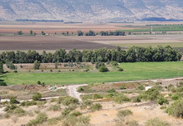
Ghuraba
About the depopulated village of Ghuraba
- District
- Safed
- Date Ghuraba was occupied
- 28 May 1948
- Population in 1948
- 260
- Military operation
- Operation Yiftach
- Brigade that carried it out
- Palmach
- Distance from the governorate centre
- 22 (km) North East of Safad
- Elevation above sea level
- 100 m
- Cause of displacement
- Fear of Jewish attack, or of being caught in the fighting
- Extent of destruction
- The village has been completely destroyed, and only house rubble left behind.
- Ethnic cleansing
- Ghuraba inhabitants were completely ethnically cleansed.
- Settlements built on the built-up area of Ghuraba after 1948
- Gonen
Hover a dot to read the village name, or click to open its card.
Borders of the depopulated village of Ghuraba
Ghuraba: A Depopulated Palestinian Village in the Safad District
Ghuraba was a Palestinian village in the Safad District, situated on the lower slopes of the Golan Heights approximately 22 km northeast of Safad, at an average elevation of about 100 metres above sea level. The village stood east of the Hula marshlands and relied heavily on irrigated agriculture and livestock raising. Its entire population was Muslim. Ghuraba was depopulated during the Nakba and the occupation of Palestine in 1948, but the approved sources differ over the precise chronology: Khalidi/PalQuest cites an Israeli military intelligence report stating that the villagers left on 1 May in fear of a Zionist attack, while Palestine Remembered lists 28 May as the village's occupation date.
Location of Ghuraba
Ghuraba stood on the lower slopes of the Golan Heights along the eastern side of the Hula Plain.
PalQuest places the village approximately 22 km northeast of Safad and gives its average elevation as about 100 metres above sea level.
It lay roughly 13 km northeast of what had been the northeastern shore of Lake Hula before the lake and marsh drainage project began in the early 1950s.
The marshlands extending north of Lake Hula lay west of the village, while the Syrian frontier stood to the east.
Nearby Palestinian communities included Khiyam al-Walid to the north, al-Dirbashiyya to the south, al-Hamra' farther north, and the settlements and agricultural lands of the wider Hula Plain.
Landscape and Water Resources
Ghuraba occupied a water-rich environment between the lower Golan slopes and the Hula Plain.
A number of springs lay near the village and supported both domestic needs and extensive irrigated cultivation.
The fertile soils and abundant water made almost all of the village's registered land cultivable.
Population of Ghuraba
The population of Ghuraba was entirely Muslim.
The official 1931 Census of Palestine recorded 124 inhabitants living in 27 houses.
By 1944/45, the official population had risen to 220.
Population of Ghuraba in selected years
- 1931124Official British Mandate census; all Muslim
- 1944/45220Official statistics
- 1948255Later estimate published by Palestine Remembered
- Estimated refugees in 19981,567Later estimate published by Palestine Remembered
The figure of 200 inhabitants for 1945 found in some secondary material is inaccurate; the official 1944/45 figure is 220.
Number of Houses in Ghuraba
Number of houses in Ghuraba
- 193127Official British Mandate census
- 194855Later estimate published by Palestine Remembered
Education and Public Services
Khalidi's principal PalQuest entry does not provide sufficiently documented information concerning an independent school, mosque, clinic, or other specific public institution in Ghuraba before the Nakba.
No unsupported institutional details are therefore added.
Economic Life in Ghuraba
Ghuraba's economy depended principally on agriculture and livestock raising.
The nearby springs and the fertile environment of the Hula Plain enabled extensive irrigated cultivation and orchards.
In 1944/45, a total of 3,406 dunums was classified as irrigated or plantation land.
Of this area, 2,928 dunums were recorded as Arab land and 478 dunums as Jewish land in the official land-use statistics.
Approximately 99 percent of the village's registered land was therefore classified as cultivated or cultivable.
Livestock raising was the other principal economic activity specifically documented by Khalidi.
Land Ownership in Ghuraba
The total registered land area of Ghuraba was 3,453 dunums in the 1944/45 statistics.
Land ownership in Ghuraba, 1944/45, using the terminology of Palestine Remembered
- Palestinian2,935 dunums85%
- Transferred to Zionists478 dunums14%
- Communal/Public40 dunums1%
Palestinian land accounted for approximately 85 percent of the total, land in the category “Transferred to Zionists” approximately 14 percent, and communal/public land approximately 1 percent.
Land Use in Ghuraba, 1944/45
PalQuest's detailed official land-use table uses the source categories Arab, Jewish, and Public. The table below preserves those categories.
Land use in Ghuraba according to PalQuest's detailed 1944/45 statistics
- Arab
- Jewish
- Public
- Plantations and irrigable land3,406 dunums
- Non-cultivable land47 dunums
Cultivated or cultivable land totaled 3,406 dunums, approximately 99 percent of Ghuraba's registered area.
Only 47 dunums, about 1 percent of the total, were classified as non-cultivable.
Palestine Remembered's simplified table places all 47 dunums of non-arable land in the Palestinian column. PalQuest's detailed statistics show that only 7 dunums were Arab land while 40 dunums were public land. The public category is therefore separated above.
The PalQuest table does not give Ghuraba a separate built-up-area figure, so no unsupported acreage is added for residential land.
Operation Yiftach and Ghuraba
Ghuraba's depopulation occurred within the broader military transformation of eastern Galilee during Operation Yiftach.
PalQuest dates Operation Yiftach from 15 April to 25 May 1948. Palmach forces conducted the operation to seize control of eastern Galilee, and the Palmach's First Battalion spearheaded the offensive at the broader operational level.
The operation combined direct military assault, expulsion following occupation, psychological pressure, and the fear generated by the rapid advance of Zionist forces.
The First Battalion's general role in Operation Yiftach does not, however, by itself establish that it carried out a documented direct assault on Ghuraba. Khalidi's dedicated village entry does not describe such a battle.
Depopulation of Ghuraba: Conflicting Dates in the Sources
The approved sources present a significant chronological discrepancy concerning Ghuraba.
Khalidi's PalQuest entry cites an Israeli military intelligence report dated 30 June 1948 stating that the inhabitants of Ghuraba left on 1 May because they feared an attack by Zionist forces.
PalQuest's entry for nearby al-Hamra' reinforces this chronology, stating that the inhabitants of al-Hamra', Khiyam al-Walid, and Ghuraba all left their villages on 1 May.
The Israeli intelligence document is not relied upon here as an independent Israeli source; it is included because it is published and discussed through PalQuest and Khalidi.
Palestine Remembered, by contrast, lists 28 May 1948 as Ghuraba's “occupation date,” associates the village with Operation Yiftach and the Palmach's First Battalion, and classifies the cause of departure as fear of a Zionist attack or of being caught in the fighting.
This creates an additional chronological problem because PalQuest formally dates Operation Yiftach as ending on 25 May, three days before the 28 May date displayed by Palestine Remembered.
The two dates should therefore not be collapsed into a single supposedly certain event.
The most cautious conclusion is that Ghuraba's inhabitants left amid the Zionist advance through eastern Galilee because they feared an impending attack. The intelligence report cited by Khalidi dates their departure to 1 May, whereas Palestine Remembered records 28 May as the occupation date. Khalidi's dedicated entry does not independently document a battle inside Ghuraba that would allow the exact date when troops entered the village to be fixed with certainty.
- Military context: Operation Yiftach.
- Operation Yiftach according to PalQuest: 15 April–25 May 1948.
- Departure date in the intelligence report cited by Khalidi: 1 May 1948.
- Cause in that report: fear of an impending Zionist attack.
- Occupation date listed by Palestine Remembered: 28 May 1948.
- Unit listed by Palestine Remembered: Palmach First Battalion.
- Village-specific attacking unit in Khalidi's account: not identified.
- Documented direct battle inside Ghuraba: not established in the principal source.
The 30 June 1948 Intelligence Report
The intelligence report referenced in the historical sources is dated 30 June 1948, not 31 June; June has only thirty days.
The document, published by PalQuest, surveyed the displacement of Palestinians from December 1947 through the end of May 1948.
Its information is used here only through PalQuest's publication and Khalidi's discussion of the document, not as an independently adopted Israeli source.
Israeli Settlement on Ghuraba's Lands
The Israeli settlement of Gonen was established in 1951 on Ghuraba's lands.
It lies north of the former Palestinian village site.
- Gonen: established in 1951 on Ghuraba's lands, north of the village site.
Ghuraba Today
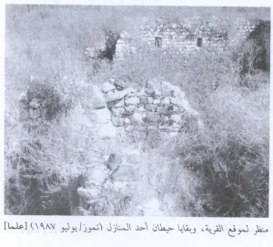
According to the field description published by Walid Khalidi in All That Remains, the former village site was fenced.
Stones from destroyed houses were scattered across the site, and sections of several truncated stone walls remained standing.
The village site and the surrounding lands were being used for livestock grazing at the time of Khalidi's field documentation.
Palestine Remembered preserves community-contributed photographs of the site, ruined houses, Gonen, and views toward the Hula Plain. In August 2025, the site also uploaded a historical photograph of Ghuraba dated to the 1980–1989 period.
The 2025 upload date should not be confused with the date of the photograph itself; it is historical rather than contemporary field documentation.
Community photographs are useful for documenting the village landscape but do not constitute a systematic independent survey of the entire site.
Khalidi's description, published in 1992, therefore remains the principal field account used here. It is an older description and does not constitute direct field verification of Ghuraba's condition in 2026. The approved sources used here do not provide a sufficiently comprehensive independent contemporary survey to verify the precise condition of every part of the site today.
Sources
- PalQuestPalQuest – Interactive Encyclopedia of the Palestine Question: Ghuraba
- PalQuestPalQuest – Operation Yiftach
- PalQuestPalQuest – Israeli Intelligence Report on the Depopulation of Palestine, 30 June 1948
- PalQuestPalQuest – al-Hamra': reference to Ghuraba's inhabitants leaving on 1 May 1948
- Palestine RememberedPalestine Remembered – Ghuraba, Safad District
- Palestine RememberedPalestine Remembered – Ghuraba entry from All That Remains
- Institute for Palestine StudiesInstitute for Palestine Studies – All That Remains, Walid Khalidi
Photo gallery


Photos from the village's people
Photos sent in by visitors and published after review.
Add a photo of this village
Log in to add photos of this village.
Other villages from Safed


More from the archive



 Download Our Palestine App
The whole archive in the palm of your hand: depopulated villages, the Nakba, the massacres and Al-Aqsa — free, with no ads to erase the story.
Download Our Palestine App
The whole archive in the palm of your hand: depopulated villages, the Nakba, the massacres and Al-Aqsa — free, with no ads to erase the story.



Comments
No comments yet — be the first to write one.
Add your comment
Name and email are optional. Comments appear after review.