
The depopulated village of Al-Zuq al-Fawqani / District of Safed

District of Safed
Al-Zuq al-Fawqani
About the depopulated village of Al-Zuq al-Fawqani
- District
- Safed
- Date Al-Zuq al-Fawqani was occupied
- 21 May 1948
- Population in 1948
- 190
- Military operation
- Operation Yiftach
- Brigade that carried it out
- Palmach
- Distance from the governorate centre
- 30 (km) North East of Safad
- Elevation above sea level
- 100 m
- Cause of displacement
- Influence of fall of, or exoduce from, neighboring town
- Extent of destruction
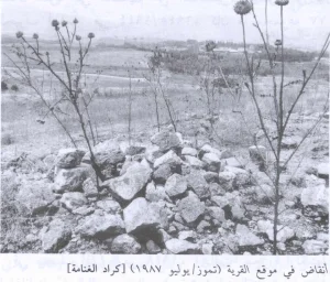
- The village has been completely destroyed, and only one house still standing.
- Ethnic cleansing
- The village has been ethnically cleansed as a result of psychological warfare conducted on the 11th of May 1948.
- Settlements built on the built-up area of Al-Zuq al-Fawqani after 1948
- Part of Yuval
Hover a dot to read the village name, or click to open its card.
Borders of the depopulated village of Al-Zuq al-Fawqani
North
al-Zuq al-Fawqani
North-east
Al-Khisas
West
Al-Khalisa
The depopulated village of Al-Zuq al-Fawqani / District of Safed
South
Al-Na'ima
South-east
Qaytiyya
District: Safed
Population 1948: 190
Occupation date: 01/05/1948
Jewish settlements on village/town land before 1948: None
Jewish settlements on village/town land after 1948: Part of Yuval
Photo gallery


Photos from the village's people
Photos sent in by visitors and published after review.
Add a photo of this village
Log in to add photos of this village.
Other villages from Safed

More from the archive



 Download Our Palestine App
The whole archive in the palm of your hand: depopulated villages, the Nakba, the massacres and Al-Aqsa — free, with no ads to erase the story.
Download Our Palestine App
The whole archive in the palm of your hand: depopulated villages, the Nakba, the massacres and Al-Aqsa — free, with no ads to erase the story.



Comments
No comments yet — be the first to write one.
Add your comment
Name and email are optional. Comments appear after review.