
The depopulated village of Al-Malikiyya / District of Safed

Al-Malikiyya
About the depopulated village of Al-Malikiyya
- District
- Safed
- Date Al-Malikiyya was occupied
- 31 October 1948
- Population in 1948
- 420
- Military operation
- Operation Yiftach
- Brigade that carried it out
- The Seventh Brigade
- Who defended the village
- Local militia & Arab Liberation Army
- Distance from the governorate centre
- 15.5 (km) North East of Safad
- Elevation above sea level
- 675 m
- Cause of displacement
- Military assault by Zionist troops
- Extent of destruction
- The village has been completely destroyed
- Ethnic cleansing
- al-Malikiyya inhabitants were completely ethnically cleansed.
- Settlements built on the built-up area of Al-Malikiyya after 1948
- Malkia
Hover a dot to read the village name, or click to open its card.
Borders of the depopulated village of Al-Malikiyya
al-Malikiyya: A Depopulated Palestinian Village in the Safad District
al-Malikiyya was a Palestinian village in the Safad District, situated in the mountains of Upper Galilee approximately 15.5 km from Safad, at an average elevation of about 675 metres above sea level and less than half a kilometre from the Lebanese frontier. The village remained part of Lebanon until the final demarcation of the Lebanon–Palestine boundary in 1923. During the Nakba and the occupation of Palestine in 1948, al-Malikiyya changed hands repeatedly between Arab and Zionist/Israeli forces. Israeli occupation forces finally captured it in late October during Operation Hiram, when the Ninth Battalion of the Sheva' (Seventh) Brigade attacked from the south under air cover.
Location of al-Malikiyya
al-Malikiyya stood in the mountains of Upper Galilee on the northern slope of a hill, less than half a kilometre from the Lebanese frontier.
It was approximately 15.5 km from Safad and had an average elevation of about 675 metres above sea level.
A secondary road connected the village with a main road leading to Safad and with neighboring villages and the coastal highway to the west.
Nearby Palestinian and Lebanese localities included Qadas, al-Nabi Yusha', Dayshum, 'Alma, Saliha, 'Aytarun, and Marun al-Ras.
al-Malikiyya and the Lebanon–Palestine Frontier
An important feature of al-Malikiyya's modern history is that the village remained part of Lebanon during the first years following the First World War.
This situation continued until 1923, when the final Lebanon–Palestine frontier was demarcated and al-Malikiyya was placed within British-administered Palestine and subsequently the Safad District.
The village therefore retained close geographic and social ties with the Jabal 'Amil region and communities lying on both sides of the newly established frontier.
al-Malikiyya through History
Walid Khalidi suggests that al-Malikiyya may have stood on the site of an earlier settlement known as Caphargun, although the identification is presented as tentative.
The Arab geographer Yaqut al-Hamawi, who died in 1229, recorded a tradition that the villagers possessed a large wooden platter they believed had belonged to the Prophet Muhammad.
In 1596, al-Malikiyya was a village in the nahiya of Tibnin within the liwa of Safad and had an estimated population of approximately 369.
The inhabitants paid taxes on wheat and barley as well as goats and beehives.
In the late nineteenth century, travellers described al-Malikiyya as a village of stone-and-mud houses on a plain east of a wadi. Its population was estimated at 200–300 and olive cultivation was prominent.
Architecture of al-Malikiyya
The village had a roughly square layout, with houses clustered closely together.
The houses were described in the late nineteenth century as being built of stone and mud.
A police post stood near the village to the southeast.
The built-up area amounted to approximately 55 dunums in the 1944/45 statistics.
Water Supply
In the late nineteenth century, al-Malikiyya obtained water from a nearby wadi.
In the Mandate period, rainwater was also collected in wells and cisterns for household use, including a well east of the village site.
Water resources and the surrounding uplands supported both agriculture and livestock raising.
Population of al-Malikiyya
The inhabitants of al-Malikiyya were Muslim.
Because the village remained administratively within Lebanon until the 1923 boundary settlement, this article does not present a 1922 Palestine census figure for al-Malikiyya as though the village had already been part of Mandatory Palestine.
Population of al-Malikiyya in selected years
- 1596369Estimate derived from Ottoman records
- Late nineteenth centuryApproximately 200–300Historical estimate
- 1931254Official Government of Palestine census; all Muslim
- 1944/45360Official statistics
- 1948418Later estimate published by Palestine Remembered
- Estimated refugees in 19982,565Later estimate published by Palestine Remembered
Number of Houses in al-Malikiyya
Number of houses in al-Malikiyya
- 193148Official Government of Palestine census
- 194878Later estimate published by Palestine Remembered
Education and Public Services
Khalidi's principal PalQuest entry does not provide sufficiently documented information concerning an independent school in al-Malikiyya, its founding date, or enrollment.
No unsupported educational details are therefore added.
A police post southeast of the village is, however, explicitly documented in the principal source.
Economic Life in al-Malikiyya
Agriculture and livestock raising were the principal sources of livelihood.
The villagers cultivated cereals, olives, and fruit.
In the 1942/43 season, approximately 105 dunums were planted with olive trees in the northern, northeastern, southern, and southwestern parts of the village lands.
In 1944/45, 4,225 dunums were devoted to cereal cultivation.
The 105-dunum olive figure should not be added as a separate category to the 1944/45 land-use table because it refers to an earlier agricultural season.
Land Ownership in al-Malikiyya
The total registered land area of al-Malikiyya was 7,328 dunums in the 1944/45 statistics.
Land ownership in al-Malikiyya, 1944/45
- Palestinian7,326 dunums100%
- Transferred to Zionists0 dunums0%
- Communal2 dunums<1%
No land was recorded in the category “Transferred to Zionists.” Almost all registered land was Palestinian, with only two dunums classified as public/communal.
Land Use in al-Malikiyya, 1944/45
Land use in al-Malikiyya according to the detailed 1944/45 figures
- Palestinian
- Communal/Public
- Cereals4,225 dunums
- Built-up area55 dunums
- Non-cultivable land3,048 dunums
The detailed categories above reconcile exactly with the registered total of 7,328 dunums.
PalQuest's online presentation also displays a cultivable-land subtotal of 4,725 dunums while explicitly listing only 4,225 dunums of cereals in that category. Adding the displayed subtotal to the built-up and non-cultivable figures would exceed the village's total registered area.
This article therefore follows the individual category figures that reconcile with the total rather than inventing an undocumented 500-dunum category.
The 105 dunums of olive groves refer to the 1942/43 season and are therefore discussed separately rather than added again to the 1944/45 table.
Historical and Archaeological Background
Khalidi tentatively associates al-Malikiyya with an earlier settlement known as Caphargun.
Yaqut al-Hamawi's thirteenth-century reference and the Ottoman records of 1596 demonstrate a long history of settlement at al-Malikiyya.
The principal approved sources used here do not provide a detailed inventory of archaeological remains within the village site, so no unsupported archaeological identifications are added.
The First Battles for al-Malikiyya in 1948
Because of its strategic position directly on the Lebanese frontier, al-Malikiyya became the site of repeated fighting in 1948.
Palestinian historian Hani al-Hindi states that the village was initially held by the Second Yarmuk Battalion of the Arab Liberation Army under Lieutenant Colonel Adib al-Shishakli.
According to his account, Palmach forces captured al-Malikiyya on the night of 12 May 1948, and Arab forces retook it the following day.
A different chronology reproduced by Khalidi cites contemporary reporting that Israeli forces entered the village on 15 May, after which Lebanese army units crossed the frontier and regained control later that day.
This disagreement illustrates why al-Malikiyya cannot accurately be assigned a single occupation date for the spring of 1948.
The May Battles and the Recapture of al-Malikiyya
Israeli forces launched another assault in the al-Malikiyya area on 20 May, according to accounts reproduced by Khalidi.
Later that month, the Haganah carried out an elaborate maneuver to retake al-Malikiyya and neighboring Qadas.
Israeli forces first attacked the Lebanese garrison to induce it to request reinforcements. An armored column then crossed into Lebanese territory by another route and approached al-Malikiyya from the rear while posing as Lebanese reinforcements.
The force surprised the actual Lebanese reinforcements and then entered al-Malikiyya in the early hours of 29 May 1948.
According to the military account reproduced by Khalidi, the village itself was empty when the force entered.
Although Arab and Zionist accounts differ over some dates in the early fighting, both agree that al-Malikiyya was in Zionist hands at the end of May.
The Lebanese Army Recaptures al-Malikiyya
Control of the village did not remain settled after the May fighting.
On 7 June 1948, the Lebanese army successfully recaptured al-Malikiyya.
Lebanese and other Arab forces retained the village throughout the summer, and al-Malikiyya remained an important frontier position on the northern front.
A late-May date found in some summary tables should therefore not be treated as the village's final occupation date.
Operation Hiram and the Final Occupation of al-Malikiyya
In late October 1948, al-Malikiyya lay at the northeastern edge of the area targeted by Operation Hiram.
Operation Hiram ran from 28 to 31 October and aimed to occupy the remaining Arab-held areas of Upper Galilee.
At the broader operational level, the Sheva' (Seventh), Carmeli, Golani, and 'Oded brigades participated; PalQuest's operation metadata also associates Giv'ati with the offensive.
Khalidi's dedicated village account is more specific regarding the final attack on al-Malikiyya. The Ninth Battalion of the Sheva' Brigade approached from the south, exploiting the fact that the village defenses had been prepared primarily against an attack from the east.
The battalion attacked under Israeli air cover and captured al-Malikiyya in late October 1948.
If some inhabitants had returned to the village during the period of Arab control in the summer, they apparently fled again during this final assault.
- Military operation associated with the final occupation: Operation Hiram.
- Operation Hiram: 28–31 October 1948.
- First Palmach capture according to Hani al-Hindi: night of 12 May.
- Early Arab recapture: the following day according to al-Hindi.
- Alternative account of the first major battle: 15 May, followed by a Lebanese recapture the same day.
- Zionist recapture: 29 May 1948.
- Lebanese army recapture: 7 June 1948.
- Final Israeli occupation: late October 1948.
- Unit responsible for the final attack: Ninth Battalion of the Sheva' (Seventh) Brigade.
- Final assault: approach from the south under air cover.
- Villagers who may have returned during the summer apparently left during the final assault.
Why al-Malikiyya Has No Single 1948 Occupation Date
al-Malikiyya differs from many depopulated Palestinian villages because control of the village did not change once and remain settled.
Between May and October 1948, it changed hands repeatedly between Arab and Lebanese forces on one side and Zionist/Israeli forces on the other.
A date such as 28 or 29 May therefore records one phase of military control rather than the end of the fighting over the village.
The final occupation—the one after which Arab forces did not regain al-Malikiyya—occurred in late October during Operation Hiram.
Israeli Settlement on al-Malikiyya's Lands
After the Nakba, an Israeli settlement bearing the name Malkiyya was established on village land.
- Malkiyya: established in 1949 southeast of the former Palestinian village site on al-Malikiyya's lands.
al-Malikiyya Today
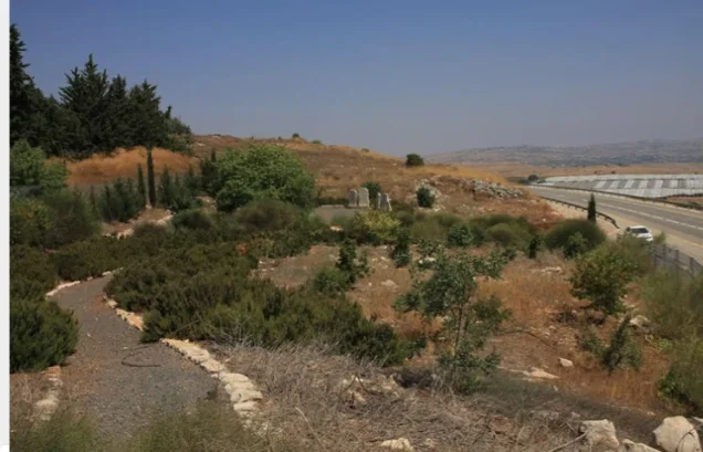
According to the field description published by Walid Khalidi in All That Remains, the former village site lies within a fenced military zone and is inaccessible.
Because access was restricted, the principal field account does not provide a detailed inventory of structures surviving inside the closed area.
Palestine Remembered preserves photographs and historical material relating to the site, including images of rubble and olive, pomegranate, and fig trees, together with maps and oral-history material.
In June 2026, the site also published a series of images taken from a historical filmed visit made after the village's occupation. Their 2026 upload date should not be confused with a 2026 field survey; the images themselves are historical material.
The principal systematic site description used here therefore remains Khalidi's field documentation published in 1992. The approved sources do not provide a sufficiently comprehensive independent contemporary survey to verify the precise condition of every part of al-Malikiyya in 2026.
Sources
- PalQuestPalQuest – Interactive Encyclopedia of the Palestine Question: al-Malikiyya
- PalQuestPalQuest – Operation Hiram
- PalQuestPalQuest – Operation Yiftach
- Palestine RememberedPalestine Remembered – al-Malikiyya, Safad District
- Palestine RememberedPalestine Remembered – al-Malikiyya entry from All That Remains
- sabil.meVillage Statistics 1945 – Safad Sub-District, built-up and non-cultivable land
- pcbs.gov.psGovernment of Palestine Census, 1931 – Safad Sub-District
- Institute for Palestine StudiesInstitute for Palestine Studies – All That Remains, Walid Khalidi
Photo gallery




Photos from the village's people
Photos sent in by visitors and published after review.
Add a photo of this village
Log in to add photos of this village.
Other villages from Safed


More from the archive



 Download Our Palestine App
The whole archive in the palm of your hand: depopulated villages, the Nakba, the massacres and Al-Aqsa — free, with no ads to erase the story.
Download Our Palestine App
The whole archive in the palm of your hand: depopulated villages, the Nakba, the massacres and Al-Aqsa — free, with no ads to erase the story.



Comments
No comments yet — be the first to write one.
Add your comment
Name and email are optional. Comments appear after review.