
The depopulated village of Baysamun / District of Safed
Baysamun
About the depopulated village of Baysamun
- District
- Safed
- Date Baysamun was occupied
- 25 May 1948
- Population in 1948
- 20
- Military operation
- Operation Yiftach
- Brigade that carried it out
- Palmach
- Distance from the governorate centre
- 16.5 (km) North East of Safad
- Elevation above sea level
- 75 m
- Cause of displacement
- Haganah 'Wispering' campaign (psychological warfare)
- Extent of destruction
- The village has been completely obliterated
- Ethnic cleansing
- Baysamun was ethnically cleansed as a result of psychological warfare conducted on the 25th of May 1948.
Hover a dot to read the village name, or click to open its card.
Borders of the depopulated village of Baysamun
Baysamun – Depopulated Palestinian Village of the Safad District
Baysamun was a depopulated Palestinian village in the Safad District. It stood on level ground along the western side of the al-Hula Plain, approximately 16.5 kilometers northeast of Safad, at an average elevation of about 75 meters above sea level.
Baysamun was one of the smallest rural communities in the Safad District. During the Mandate it was classified as a hamlet or farm. Its inhabitants depended on cereal cultivation, orchards, and livestock raising and benefited from springs situated to the west and south of the village.
The villagers were displaced on 25 May 1948 as a direct result of a Palmach psychological-warfare or “whispering” campaign conducted in the context of Operation Yiftach. Regional accounts indicate that Baysamun fell under Israeli control at the end of the operation on the same day, without a documented large-scale battle inside the village itself.
Location and Geography
Baysamun stood on a flat tract of land facing a mountain range to the west and overlooking the al-Hula Plain in the other directions.
It lay approximately 16.5 kilometers northeast of Safad at an average elevation of about 75 meters above sea level.
A short dirt road linked the village to a highway that passed to its west and led toward Safad and Tiberias.
Supporting Palestinian documentation places Jahula to the north, Lake al-Hula to the east, the encampments of 'Arab al-Zubayd to the south, and Dayshum to the west.
Name
The origin of the name Baysamun is not conclusively established.
Walid Khalidi suggests that the name may derive from “Bayt Ashmun,” Ashmun being a Phoenician deity, giving the possible meaning “Temple of Ashmun.”
Because Khalidi himself presents the derivation as a possibility, it should not be treated as a settled linguistic or historical fact.
Built Environment
Baysamun was a very small settlement and was classified as a hamlet or farm in the Mandate-era Palestine Index Gazetteer.
Its houses were scattered along both sides of the dirt road connecting the village with the main highway, generally extending along an east–west axis, with some dwellings clustering around a spring south of the village.
The official statistical material reviewed does not provide a reliable separate built-up-land figure, so no unsupported built-up acreage is added.
Population and Houses
The inhabitants of Baysamun during the Mandate period were Muslims.
- 192241Official Census of Palestine; all inhabitants were Muslims
- 193150Official census; all inhabitants were Muslims
- 194520Official statistics
- 1948About 23Later demographic estimate, not an official Mandate census
- 1998About 143 refugees and descendantsLater estimate published by Palestine Remembered
The official 1931 census recorded 11 houses in Baysamun.
The official population fell from 50 in 1931 to 20 in 1945. The principal sources reviewed do not provide a conclusive explanation for this decline, so no specific cause is assigned without documentation.
Education and Religious Institutions
Walid Khalidi and PalQuest do not document an independent school in Baysamun before the Nakba.
The principal source also does not identify a particular mosque or shrine in this very small settlement.
No specific educational or religious institution is therefore added without stronger village-level Palestinian documentation.
Water Resources
Several springs were located to the west and south of Baysamun.
Some of the village houses clustered around a spring on the southern side.
These water sources supported domestic needs and limited irrigated agriculture.
Economic Life and Agriculture
The inhabitants depended on agriculture and livestock raising.
Cereals were the principal crop, while some land was devoted to orchards and irrigated agriculture.
Orange trees were planted north of the village.
The villagers also kept livestock as part of the local rural economy.
Land Ownership, 1944/45
The total land area of Baysamun was 2,102 dunams.
- Arab2,057 dunums98%
- Jewish0 dunums0%
- Public45 dunums2%
The figures balance exactly: 2,057 + 45 = 2,102 dunams.
Palestine Remembered presents the same figures using its own terminology: 2,057 dunams “Palestinian,” 0 dunams “Transferred to Zionists,” and 45 dunams “Communal/Public.”
The phrase “Transferred to Zionists” should be preserved when reproducing that source's classification.
Land Use, 1944/45
- Arab
- Public
- Cereals1,817 dunums
- Plantations and irrigable land107 dunums
- Total cultivable/cultivated land1,924 dunums
- Non-cultivable/non-agricultural category178 dunums
The table balances exactly: 1,924 dunams of cultivated or cultivable land plus 178 dunams in the non-agricultural category equal the total village area of 2,102 dunams.
PalQuest's display contains a formatting inconsistency: one summary line shows 113 Arab dunams in the non-cultivable category, while the detailed line shows 133.
The 133-dunam figure is the one that reconciles with the official ownership total, since 1,817 + 107 + 133 = 2,057 Arab dunams.
This article therefore uses 133 and does not invent a separate built-up acreage.
Operation Yiftach
Operation Yiftach began on 15 April and ended on 25 May 1948.
The Palmach conducted the operation to gain control of eastern Galilee before and immediately after the end of the British Mandate. The operation later became associated with the Yiftach Brigade.
The Palmach's First Battalion served as the spearhead of the operation at the broader operational level.
The campaign targeted Safad and Palestinian villages throughout eastern Galilee and the Galilee panhandle and relied on both direct military attack and psychological warfare.
The Whispering Campaign
One of the principal methods used in Operation Yiftach was a psychological-warfare campaign commonly described as the “whispering campaign,” organized under Palmach commander Yigal Allon.
Messages and rumors were passed to Palestinian villagers warning them of major Jewish reinforcements and an impending clearing of villages in the al-Hula region, while supposedly friendly intermediaries advised residents to leave.
The campaign contributed to the depopulation of several communities even where no large direct battle occurred inside the village itself.
Depopulation of Baysamun
According to an Israeli military intelligence report prepared in June 1948 and cited by Walid Khalidi, the inhabitants of Baysamun left on 25 May 1948 as a direct result of the Palmach whispering campaign.
25 May is therefore first and foremost a securely documented depopulation date.
The Baysamun village account does not describe a major direct battle or a detailed ground assault inside the village on that day.
Final Control of the Village
Khalidi's account of neighboring Harrawi states that Baysamun and Mallaha fell into Israeli hands at the end of Operation Yiftach on 25 May 1948.
The same date may therefore be used as the best-supported date for final Israeli control of Baysamun, while preserving the distinction between the documented flight of the villagers caused by psychological warfare and the physical military entry into the village site, which is not described in detail in the Baysamun entry itself.
Military Unit
The military organization directly associated with Baysamun's depopulation in the principal account is the Palmach, through its psychological-warfare campaign within Operation Yiftach.
At the operation-wide level, the Palmach's First Battalion spearheaded Operation Yiftach.
Palestine Remembered accordingly lists the First Battalion as the unit associated with Baysamun.
Khalidi's village-specific account, however, does not describe a direct First Battalion assault on Baysamun itself. The distinction between operation-level attribution and a village-level ground attack is therefore retained.
Occupation Chronology
- 15 April 1948
Beginning of Operation Yiftach
The Palmach began its campaign to gain control of eastern Galilee, Safad, and the al-Hula villages.
- May 1948
Psychological warfare in the al-Hula region
The whispering campaign was used to frighten Palestinian villagers and induce them to leave.
- 25 May 1948
Depopulation of Baysamun
An Israeli military intelligence report cited by Khalidi states that the villagers left as a direct result of the Palmach whispering campaign.
- 25 May 1948
Probable final Israeli control
Regional village accounts place Baysamun and Mallaha in Israeli hands at the end of Operation Yiftach.
- 25 May 1948
End of Operation Yiftach
Baysamun's depopulation and final fall occurred at the closing stage of the operation.
- After depopulation; exact date not documented
Destruction of the village
The village houses were later completely removed.
Israeli Settlements on Village Lands
According to Walid Khalidi and PalQuest, no Israeli settlement was established on the village site or on Baysamun's lands.
Agricultural facilities used by Kibbutz Manara later occupied the village site, but this does not mean that Manara itself was established on Baysamun village land.
Baysamun Today
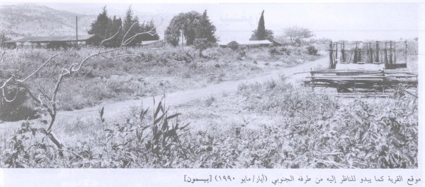
According to the field description published in Walid Khalidi's All That Remains, no traces of the village houses remained.
Warehouses for agricultural implements used by Kibbutz Manara occupied the site.
The surrounding land was cultivated, and fish ponds had been constructed nearby.
Palestinian documentation also preserves a field photograph of the village site from the south dated 1990.
This description should not be treated as a comprehensive field verification of conditions in 2026. Fieldwork for All That Remains was conducted between 1987 and 1990 and therefore records the condition of the site during that survey period.
Sources
- PalQuest – Interactive Encyclopedia of the Palestine Question: Baysamun
- PalQuest – Operation Yiftach
- Palestine Remembered – Baysamun, Safad District
- Palestine Remembered – Walid Khalidi's account of Baysamun
- Palestinian Villages Encyclopedia – Baysamun; supporting Palestinian local documentation
- Palestinian Central Bureau of Statistics – Historical census reports for 1922, 1931, and 1945
- Institute for Palestine Studies – Walid Khalidi, All That Remains
- PalQuest – All That Remains: Methodology and Fieldwork
Photo gallery


Photos from the village's people
Photos sent in by visitors and published after review.
Add a photo of this village
Log in to add photos of this village.
Other villages from Safed

More from the archive



 Download Our Palestine App
The whole archive in the palm of your hand: depopulated villages, the Nakba, the massacres and Al-Aqsa — free, with no ads to erase the story.
Download Our Palestine App
The whole archive in the palm of your hand: depopulated villages, the Nakba, the massacres and Al-Aqsa — free, with no ads to erase the story.



Comments
No comments yet — be the first to write one.
Add your comment
Name and email are optional. Comments appear after review.