
The depopulated village of Al-Sanbariyya / District of Safed
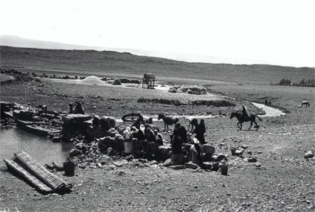
Al-Sanbariyya
About the depopulated village of Al-Sanbariyya
- District
- Safed
- Date Al-Sanbariyya was occupied
- 01 May 1948
- Population in 1948
- 151
- Military operation
- Operation Yiftach
- Brigade that carried it out
- Palmach
- Distance from the governorate centre
- 31.5 (km) North East of Safad
- Elevation above sea level
- 150 m
- Cause of displacement
- Military assault by Zionist troops
- Extent of destruction
- The village has been completely obliterated on the orders of the Jewish National Fund official Yosif Witz
- Ethnic cleansing
- al-Sanbariyya inhabitants were completely ethnically cleansed.
- Settlements built on the land of Al-Sanbariyya before 1948
- Ma'ayan Baruch
- Settlements built on the built-up area of Al-Sanbariyya after 1948
- Ma'ayan Baruch expansion
Hover a dot to read the village name, or click to open its card.
Borders of the depopulated village of Al-Sanbariyya
Al-Sanbariyya – A Depopulated Palestinian Village in the Safad Subdistrict
Al-Sanbariyya was a Palestinian village in the Safad Subdistrict, located approximately 31.5 km northeast of the city of Safad. It stood on gently sloping ground at the northern edge of the al-Hula Plain, at an average elevation of about 150 meters above sea level, close to Wadi Hasibani.
The inhabitants of al-Sanbariyya were displaced during the Nakba and the occupation of Palestine in 1948. Although 1 May 1948 is frequently given as the date on which the village was occupied, Walid Khalidi and PalQuest state that the precise date is unknown and cautiously place its occupation in May 1948, within the operational area of Operation Yiftach.
Location and Geography of Al-Sanbariyya
Al-Sanbariyya was situated on gently sloping terrain at the northern end of the al-Hula Plain. Its houses had no regular geometric layout and were scattered along the network of roads and tracks linking the village with nearby communities.
Palestine Remembered places al-Zuq al-Fawqani roughly to the northwest, Ghajar to the north, al-Shawka al-Tahta to the east, al-Mansura to the southeast, al-Khisas to the south, and al-Manshiyya to the southwest. The village lands also bordered lands belonging to al-Shawka al-Tahta, al-Zuq al-Fawqani, al-Zuq al-Tahtani, and al-Khisas.
- Subdistrict
- Safad
- Distance from Safad
- Approximately 31.5 km northeast
- Average elevation
- Approximately 150 m above sea level
- Physical setting
- Northern edge of the al-Hula Plain, near Wadi Hasibani
- Total land area, 1944/45
- 2,532 dunums
Population of Al-Sanbariyya
The official 1931 Census of Palestine recorded 83 inhabitants living in 20 occupied houses. The census table shows that 77 were Muslims and 6 were Christians.
In the 1944/45 statistics, the village population was recorded as 130. Palestine Remembered gives an estimated population of 151 for 1948; this is a later estimate rather than an official census figure. The same source estimates the number of refugees originating from the village at 926 in 1998.
- 193183Official census; 77 Muslims and 6 Christians
- 1944/45130Official British Mandate statistics
- 1948151Later estimate given by Palestine Remembered, not an official census
- 1998926 refugeesLater estimate of refugees and their descendants
Number of Houses
- 193120Official census
- 194836Later estimate reported by Palestine Remembered
Land Ownership in Al-Sanbariyya
The total area of al-Sanbariyya in the 1944/45 statistics was 2,532 dunums. Palestine Remembered presents the simplified land-ownership categories as follows:
- Palestinian2,284 dunums90%
- Transferred to Zionists198 dunums8%
- Communal/Public50 dunums2%
The figures correspond to the official categories reproduced by PalQuest: 2,284 dunums classified as Arab land, 198 dunums as Jewish land, and 50 dunums as public land.
Land Use in 1944/45
- Arab
- Jewish
- Public
- Cereals1,893 dunums
- Plantations and irrigable land583 dunums
- Non-cultivable land56 dunums
A total of 2,476 dunums, approximately 98 percent of the village lands, were classified as cultivable. The 56 dunums of non-cultivable land should not be attributed entirely to Palestinian ownership: the detailed table identifies 6 dunums as Arab and 50 dunums as public land.
Economic Life in Al-Sanbariyya
Agriculture formed the basis of the village economy. Cereals occupied the largest share of cultivated land, with 1,893 dunums devoted to cereal production in the land-use table, including 1,739 Arab-owned dunums and 154 Jewish-owned dunums.
Plantations and irrigable land covered another 583 dunums, of which 539 were classified as Arab land and 44 as Jewish land. Walid Khalidi also records that villagers cultivated fruits and vegetables on the northern and southern sides of the village site.
Water
The inhabitants obtained their drinking water from nearby springs. The village was also geographically associated with Wadi Hasibani, and remains of a Roman bridge crossing the wadi were recorded north of the village.
Education and Services
The principal sources used for this article do not provide sufficiently documented information to establish the existence of a formal school in al-Sanbariyya, its founding date, or the number of pupils. Such details have therefore not been asserted on the basis of unverified local accounts.
Archaeological Remains
The area surrounding al-Sanbariyya contained evidence of very early human activity. Walid Khalidi records a prehistoric site more than 100,000 years old a little over one kilometer north of the village, on a terrace approximately 100 meters higher than the village site.
Several cave tombs dating to the end of the third millennium BCE were also identified near the village and on its lands. Archaeologists additionally discovered an inscription on a Roman column referring to the Roman emperor Julian, who lived in the fourth century CE. The column was found immediately north of al-Sanbariyya, near a Roman bridge over Wadi Hasibani. These discoveries indicate ancient settlement in the surrounding area, although they do not in themselves demonstrate uninterrupted settlement between those periods and the modern Palestinian village.
Occupation and Depopulation of Al-Sanbariyya in 1948
The precise date on which al-Sanbariyya was occupied is not known. Palestine Remembered lists 1 May 1948, but Walid Khalidi states more cautiously that the village was probably occupied sometime in May 1948 because it lay within the area targeted by Operation Yiftach in eastern Galilee.
Operation Yiftach ran from 15 April to 25 May 1948 and was conducted within the framework of Plan Dalet to gain control of eastern Galilee before the termination of the British Mandate. Palmach forces carried out the operation, with the Palmach's First Battalion serving as its spearhead.
It is important, however, to distinguish between the First Battalion's general role in Operation Yiftach and the identity of the unit that entered al-Sanbariyya itself. Palestine Remembered identifies the First Battalion as the attacking unit, while Khalidi's village-specific entry does not independently identify the unit that actually entered the village. The occupation can therefore be securely associated with Operation Yiftach and the Palmach, while the specific assault unit remains less firmly established.
- Date of occupation
- Precise date unknown; probably May 1948
- Date listed by Palestine Remembered
- 1 May 1948
- Military operation
- Operation Yiftach
- Duration of operation
- 15 April – 25 May 1948
- Main force
- Palmach; its First Battalion spearheaded the operation generally
- Village-specific assault unit
- Not independently identified in Khalidi's village entry; Palestine Remembered attributes it to the Palmach's First Battalion
Destruction of the Village Houses
Walid Khalidi, citing an Israeli account discussed in his work, reports that later in the summer of 1948 a Jewish National Fund official toured the area and found that a number of houses in al-Sanbariyya were still standing, although they had lost their roofs. Khalidi considered the roofless houses an indication that the village had been directly attacked.
According to the account transmitted by Khalidi, the official instructed the secretariat of the nearby settlement of Ma'yan Barukh to demolish the remaining houses. The proposed demolition was explicitly linked to preventing the villagers from returning and facilitating the acquisition of village lands. The proposal was reportedly accepted immediately and was presumably implemented soon afterward.
Israeli Settlements on and near Al-Sanbariyya's Lands
Ma'yan Barukh: Established in 1947 on al-Sanbariyya's land, immediately north of the village site. This is the settlement clearly identified by Khalidi and PalQuest as having been founded on village land.
Dafna: Established in 1939 approximately 3 km east of al-Sanbariyya. Khalidi describes it as a nearby settlement but does not state that it was founded on al-Sanbariyya's land. It should therefore not be classified as a settlement established on the village lands.
Yuval: Established in 1952 on land belonging to the depopulated Palestinian village of Abil al-Qamh, approximately one kilometer northwest of the al-Sanbariyya site. It was not established on al-Sanbariyya's land.
Al-Sanbariyya Today
According to the field description published by Walid Khalidi in All That Remains, the uneven village site was covered with grass and trees, including a number of old olive trees, and no clearly recognizable remains of the original village were visible. The surrounding lands were being cultivated by Israeli farmers.
This description is based on fieldwork conducted before the publication of All That Remains in 1992 and should not be treated as a direct field verification of conditions at the site in 2026. Palestine Remembered contains later community documentation whose captions refer to cactus growth and traces of demolished houses, but the dates on which those materials were actually recorded are not sufficiently established to treat them as a comprehensive current survey.
Sources
PalQuest – Interactive Encyclopedia of the Palestine Question, “al-Sanbariyya.”
PalQuest – “Operation Yiftach.”
Walid Khalidi, ed., All That Remains: The Palestinian Villages Occupied and Depopulated by Israel in 1948, Institute for Palestine Studies, 1992.
Palestine Remembered – al-Sanbariyya, Safad.
E. Mills, Census of Palestine 1931: Population of Villages, Towns and Administrative Areas, Government of Palestine, 1932.
Government of Palestine, Village Statistics, 1945.
Photo gallery


Photos from the village's people
Photos sent in by visitors and published after review.
Add a photo of this village
Log in to add photos of this village.
Other villages from Safed

More from the archive



 Download Our Palestine App
The whole archive in the palm of your hand: depopulated villages, the Nakba, the massacres and Al-Aqsa — free, with no ads to erase the story.
Download Our Palestine App
The whole archive in the palm of your hand: depopulated villages, the Nakba, the massacres and Al-Aqsa — free, with no ads to erase the story.



Comments
No comments yet — be the first to write one.
Add your comment
Name and email are optional. Comments appear after review.