
The depopulated village of Al-Ja'una / District of Safed

Al-Ja'una
About the depopulated village of Al-Ja'una
- District
- Safed
- Date Al-Ja'una was occupied
- 09 May 1948
- Population in 1948
- 1,334
- Military operation
- Operation Yiftach
- Brigade that carried it out
- The Palmach (Yiftach Brigade, spearheaded by its First Battalion) at the level of the operation; the sources do not name the unit that occupied al-Ja'una
- Distance from the governorate centre
- 5 km east of Safad
- Elevation above sea level
- 500 m
- Cause of displacement
- The village's fate was closely linked to that of the neighbouring city of Safad in the course of Operation Yiftach; those who remained were forcibly expelled by Israeli occupation forces on 5 June 1949
- Extent of destruction
- The village has been mostly destroyed with the exception of several houses being used by the Jewish settlement of Ro'sh Pinna
- Ethnic cleansing
- al-Ja'una was mostly ethnically cleansed in early May 1948, but some people remained until June 5th 1949, then they were forcibly kicked out to Lebanon.
- Settlements built on the land of Al-Ja'una before 1948
- Rosh Pinna: established in 1878 on land purchased from the villagers of al-Ja'una and re-established in 1882, it expanded after 1948 beyond the area purchased by its founders to occupy the village lands, and today occupies the village site
Hover a dot to read the village name, or click to open its card.
Borders of the depopulated village of Al-Ja'una
al-Ja'una: A Depopulated Palestinian Village in the Safad District
al-Ja'una was a Palestinian village in the Safad District, situated on the eastern slope of Mount Kan'an approximately 5 kilometres from the city of Safad, at an average elevation of about 500 metres above sea level. Its population reached 1,150 in the 1944/1945 statistics. Most of its inhabitants were displaced in early May 1948, probably by 9 May during Operation Yiftach, while a number of villagers remained until they were forcibly expelled on 5 June 1949.
- Subdistrict
- Safad
- Distance from district center
- 5 km east of Safad
- Average Elevation
- 500 m above sea level
- Population in 1931
- 799
- Number of Houses in 1931
- 149
- Population in 1944/1945
- 1,150
- Estimated Population in 1948
- About 1,334 – a later demographic estimate, not an official census
- Total Land Area in 1945
- 839 dunams
- Attack and Depopulation
- The available sources document no direct attack on the village; according to Benny Morris as cited by Khalidi, its inhabitants left before 2 May 1948 in one account, or it was emptied of them on 9 May 1948 during the final attack on Safad in another, and it was occupied in the course of Operation Yiftach. Some of its inhabitants remained until they were forcibly expelled on 5 June 1949.
- Final Israeli Control
- During Operation Yiftach (15 April – 25 May 1948); the available sources give no date for its occupation, and Morris's two accounts, as cited by Khalidi, differ on when it was emptied of its inhabitants: before 2 May or on 9 May 1948
- Military Operation
- Operation Yiftach
- Military Unit
- The Palmach – the Yiftach Brigade according to PalQuest's page on the operation, which the Palmach's First Battalion spearheaded; the available sources do not name the specific unit that occupied al-Ja'una
- Cause of Depopulation
- The village's fate was closely linked to that of the neighbouring city of Safad in the course of Operation Yiftach; those who remained were forcibly expelled by Israeli occupation forces on 5 June 1949
- Settlements Documented on Village Lands
- Rosh Pinna: established in 1878 on land purchased from the villagers of al-Ja'una and re-established in 1882, it expanded after 1948 beyond the area purchased by its founders to occupy the village lands, and today occupies the village site
Location
al-Ja'una stood on the eastern slope of Mount Kan'an, approximately 5 kilometres from Safad, at an average elevation of about 500 metres above sea level.
Its location overlooked the Jordan Valley in nearly every direction except the west and provided broad views toward the Hula and Tiberias regions.
The village stood close to the western side of the main road linking Safad and Tiberias and was connected with routes leading toward Jisr Banat Ya'qub and Damascus.
al-Ja'una Through History
In 1596, al-Ja'una was a village in the nahiya of Jira in the Safad district, with an estimated population of approximately 171.
The villagers paid taxes on wheat, barley, olives, goats, beehives, and a water-powered mill.
In the late nineteenth century, al-Ja'una was described as a stone-built village with an estimated population of approximately 140–200 inhabitants who cultivated figs and olives.
Architecture and Public Facilities
Most houses in al-Ja'una were built of stone, and the village developed gradually along the slope of Mount Kan'an and the surrounding local roads.
The built-up area covered approximately 43 dunams in the 1944/1945 statistics.
The entire village population was Muslim.
al-Ja'una contained a mosque and other structures associated with its agricultural and daily life.
Education
al-Ja'una had a boys' elementary school established during the Ottoman period, which continued to operate under the British Mandate.
Palestine Remembered records the fourth elementary grade as the school's highest class.
Local accounts state that the school stood in the eastern part of the village and was constructed of stone with a tiled roof. These architectural details derive primarily from local village documentation and are not all recorded to the same degree in the principal reference sources.
Population
The 1922 census recorded 626 inhabitants in al-Ja'una, all Muslims.
In the 1931 census, the population increased to 799, again all Muslims, living in 149 houses.
According to the 1944/1945 statistics, the village population reached 1,150.
The estimates of approximately 1,334 inhabitants in 1948 and 8,192 refugees and descendants in 1998 are later estimates rather than official British Mandate census figures.
Population of al-Ja'una
- 1596About 171Historical estimate based on Ottoman records
- Late nineteenth centuryAbout 140–200Historical estimate
- 1922626Official census; all Muslims
- 1931799Official census; all Muslims
- 1944/19451,150Government of Palestine statistics
- 1948About 1,334Later estimate
- 19988,192Estimate of refugees and their descendants
Number of Houses
The 1931 census recorded 149 houses in al-Ja'una.
The figure of approximately 248 houses for 1948 published by Palestine Remembered is a later estimate rather than an official census count.
Land of al-Ja'una
According to the 1944/1945 statistics, al-Ja'una had a total land area of 839 dunams.
Arab ownership amounted to 824 dunams, Jewish ownership to 7 dunams, while 8 dunams were classified as public land.
Land Ownership in al-Ja'una in 1944/1945
- Arab ownership824 dunums98%
- Jewish ownership7 dunums<1%
- Public land8 dunums<1%
Agriculture and Economic Life
Most inhabitants of al-Ja'una worked in agriculture or construction, while livestock raising also formed part of village life.
Despite limited water resources, the villagers cultivated cereals, olives, figs, prickly pears, and grapes.
According to the 1944/1945 statistics, 248 dunams were devoted to cereals, while irrigated and plantation land covered 179 dunams in total: 172 Arab-owned dunams and 7 Jewish-owned dunams.
Palestine Remembered records approximately 171 dunams planted with olive trees. This represents a crop category within cultivated land and should not be added separately to the overall land-use total.
Land Use in al-Ja'una in 1944/1945, in Dunams
- Arab
- Jewish
- Public
- Cereals248 dunums
- Irrigated and plantation land179 dunums
- Built-up area43 dunums
- Uncultivable land369 dunums
Operation Yiftach
Operation Yiftach began on 15 April 1948 and continued until 25 May. It was conducted by Palmach forces in eastern Galilee with the objective of securing control over the region before the end of the British Mandate.
al-Ja'una is listed among the Palestinian villages directly affected by the operation.
PalQuest states that the Palmach's First Battalion spearheaded Operation Yiftach as a whole, while the Palestine Remembered summary specifically attributes the attack on al-Ja'una to the First Battalion.
The detailed PalQuest village entry, however, does not independently identify the battalion that directly entered al-Ja'una. The First Battalion attribution should therefore be treated as supported by the summary source but not independently established in every detailed account.
The Nakba and the Occupation of al-Ja'una
The fate of al-Ja'una was closely linked to that of neighbouring Safad.
The accounts transmitted by Walid Khalidi and PalQuest differ over the precise date on which most of al-Ja'una's inhabitants left.
One account places the departure before 2 May 1948 and states that it contributed to growing fear among the inhabitants of Safad.
Another account dates the depopulation to 9 May 1948, during the final phase of the assault on Safad.
Palestine Remembered also gives 9 May as the village's summary occupation date.
The most cautious formulation is therefore that most inhabitants of al-Ja'una were displaced in early May 1948, with military control probably consolidated around 9 May during Operation Yiftach.
Information drawn from Israeli historian Benny Morris is cited here only as transmitted through Walid Khalidi and PalQuest and not through direct reliance on Israeli sources.
Occupation and Depopulation Chronology
- 15 April 1948
Beginning of the military operation
The Palmach launched Operation Yiftach to take control of eastern Galilee before the end of the British Mandate, spearheaded by the Palmach's First Battalion; PalQuest lists al-Ja'una among the villages affected by the operation. PalQuest's entry on al-Ja'una states that the operation was launched in the second half of April.
- Before 2 May 1948 or 9 May 1948
Depopulation of the village
Benny Morris, as cited by Khalidi, writes that the evacuation of al-Ja'una occurred some time before 2 May and led to increased panic among Safad's residents, and elsewhere that the village was depopulated on 9 May, at the time of the final attack on Safad. In either case the village was occupied in the course of Operation Yiftach, and the available sources give no date for its occupation.
- 5 June 1949
Expulsion of the remaining inhabitants
At midnight, trucks of the Israeli occupation forces surrounded al-Ja'una and the villages of al-Khisas and Qaytiyya, and the remaining inhabitants were forced into them 'with brutality ... with kicks, curses and maltreatment', in the words of Knesset member Eli'ezer Pra'i, then dumped on a bare hillside near the village of 'Akbara, nearly 5 km to the southwest. Morris, as cited by Khalidi, recounts this and states that the refugees from al-Ja'una remained in 'Akbara for years under degrading conditions of overcrowding.
- After 1948
Settlement expansion onto village lands
The settlement of Rosh Pinna, whose population was less than 400 at the beginning of 1948 and reached 1,480 by 1953, most of them immigrants, expanded beyond the area purchased by its founders to occupy the lands of al-Ja'una, and came to occupy the village site.
Villagers Who Remained Until 1949
al-Ja'una was not completely emptied in May 1948. A number of its Palestinian inhabitants remained in the village for more than a year after its occupation.
At midnight on 5 June 1949, Israeli army trucks surrounded al-Ja'una and the remaining inhabitants were forcibly removed.
The same operation affected the remaining residents of al-Khisas and Qaytiyya.
The expelled villagers were transported by truck and left on a hillside near 'Akbara, southwest of Safad.
PalQuest, through the sources used by Walid Khalidi, records the protest of a Mapam Knesset member regarding the violent treatment of the villagers during the expulsion.
Some of the displaced inhabitants of al-Ja'una subsequently remained in the 'Akbara area for years under difficult and overcrowded conditions.
Rosh Pinna and the Lands of al-Ja'una
The history of Rosh Pinna was connected with al-Ja'una's lands well before the Nakba.
In 1878, an initial Jewish settlement was established southeast of al-Ja'una on land purchased from some of the village's inhabitants.
The first settlement attempt did not survive, and it was re-established in 1882, later becoming known as Rosh Pinna.
Its population remained below 400 at the beginning of 1948 but increased rapidly after the Nakba with the arrival of new immigrants.
Walid Khalidi and PalQuest state that after 1948 Rosh Pinna expanded beyond the land originally purchased by its founders and absorbed additional land belonging to al-Ja'una.
| Year | Development |
|---|---|
| 1878 | First settlement established on land purchased from some villagers of al-Ja'una |
| 1882 | Settlement re-established after the failure of the first attempt |
| After 1948 | Rosh Pinna expanded beyond the land originally purchased and absorbed additional parts of al-Ja'una's lands and village site |
al-Ja'una After the Nakba
According to the field documentation relied upon by Walid Khalidi, the expansion of Rosh Pinna came to occupy the al-Ja'una village site.
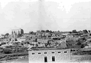
A significant number of the Palestinian village houses remained standing. Some were subsequently used, while other stone houses were abandoned or damaged.
One surviving stone house was noted for an entrance topped by a basket-handle arch.
This description reflects the condition of the site during the field documentation relied upon by Walid Khalidi and should not necessarily be interpreted as a comprehensive survey updated to 2026.
Sources
- PalQuest – Interactive Encyclopedia of the Palestine Question: al-Ja'una.
- PalQuest: al-Ja'una.
- PalQuest: Operation Yiftach.
- PalQuest: 'Akbara.
- Palestine Remembered: al-Ja'una, Safad District.
- Walid Khalidi, All That Remains: al-Ja'una, as reproduced by Palestine Remembered.
- Walid Khalidi, All That Remains, entry on al-Ja'una.
- Government of Palestine, censuses of 1922 and 1931.
- Government of Palestine, Department of Statistics, Village Statistics, 1945.
Photo gallery


Photos from the village's people
Photos sent in by visitors and published after review.
Add a photo of this village
Log in to add photos of this village.
Other villages from Safed

More from the archive



 Download Our Palestine App
The whole archive in the palm of your hand: depopulated villages, the Nakba, the massacres and Al-Aqsa — free, with no ads to erase the story.
Download Our Palestine App
The whole archive in the palm of your hand: depopulated villages, the Nakba, the massacres and Al-Aqsa — free, with no ads to erase the story.



Comments
No comments yet — be the first to write one.
Add your comment
Name and email are optional. Comments appear after review.