
The depopulated village of 'Alma / District of Safed
About the depopulated village of 'Alma
- District
- Safed
- Date 'Alma was occupied
- 30 October 1948
- Population in 1948
- 1,100
- Military operation
- Operation Hiram
- Elevation above sea level
- 675 m
Hover a dot to read the village name, or click to open its card.
Borders of the depopulated village of 'Alma
'Alma – Safad Subdistrict
'Alma was a depopulated Palestinian village in the Safad subdistrict, situated in the heart of Upper Galilee approximately 10 km north of Safad at an average elevation of about 675 meters above sea level and only about 4 km south of the Lebanese border.
The village stood on uneven mountainous terrain surrounded by fertile agricultural land and was linked by secondary roads to neighboring villages. With 19,498 dunums, 'Alma had one of the larger village land areas in the Safad subdistrict.
The official 1931 Census of Palestine recorded 712 inhabitants, and the 1944/45 statistics recorded 950. 'Alma was among the last Palestinian villages of Safad to be occupied during the Nakba. Israeli occupation forces reached it on 30 October 1948 during the final stages of Operation Hiram.
Location of 'Alma
'Alma stood in the mountainous landscape of Upper Galilee, north of Safad and very close to the Palestine–Lebanon frontier.
Its proximity to southern Lebanon meant that villagers sometimes traveled to Lebanese towns to obtain goods that were unavailable locally, according to Palestinian community documentation.
Secondary roads connected 'Alma with al-Rihaniyya, Dayshum, Fara, and other neighboring communities.
Neighboring Villages and Areas
Palestinian local documentation places the geographical surroundings approximately as follows:
| Direction | Village / Area |
|---|---|
| North | al-Malikiyya and Dayshum |
| East | Dayshum |
| Southeast | Marus |
| South and southwest | al-Rihaniyya and al-Ras al-Ahmar |
| West | Fara |
| Northwest | Saliha |
These directions describe the wider geographical neighborhood; original Mandate cadastral maps remain the stronger source for precise land boundaries.
The Name and Earlier History of 'Alma
The Crusaders referred to the site as Alme.
In 1596, 'Alma was a village in the nahiya of Jira in the liwa' of Safad, with an estimated population of approximately 239.
The villagers paid taxes on goats and beehives, while a water-powered mill and a press used for olives or grapes were also recorded.
Palestinian local sources propose several Syriac or Phoenician explanations for the name, but Khalidi does not establish one definitive etymology.
'Alma in the Late Nineteenth Century
Late nineteenth-century descriptions portray 'Alma as a stone-built village of approximately 250 inhabitants, situated amid fertile land and gardens.
During the Mandate period, the village developed into one of the more important agricultural communities of northern Safad district.
Population of 'Alma
- 1596Approximately 239Estimate derived from an Ottoman tax register
- Late nineteenth centuryApproximately 250Contemporary Survey of Western Palestine estimate
- 1922309Official Census of Palestine; all inhabitants were Muslims
- 1931712Official Census of Palestine; all inhabitants were Muslims
- 1944/45950Official Government of Palestine statistics; all were Arabs and Muslims
- 19481,102Later Palestine Remembered estimate; not an official Mandate census
- 19986,767 refugees and descendantsLater demographic estimate published by Palestine Remembered
Correction to the 1922 Population Figure
Palestine Remembered and some Palestinian online reference pages currently give a figure of 632 inhabitants for 'Alma in 1922.
The official 1922 Census of Palestine, however, records approximately 309 Muslims in 'Alma.
This article therefore uses the official figure of 309 and treats 632 as a transcription or aggregation error rather than the village's actual census population.
Number of Houses
- 1931148 occupied housesOfficial Census of Palestine
- 1948229Later Palestine Remembered estimate; not an official census figure
Built Environment and Public Services
'Alma's houses were primarily stone-built, and the village expanded as its population grew during the British Mandate.
A mosque stood near the center of the village and an elementary school stood on its eastern side. Local Palestinian documentation also records a public square near the mosque and mukhtar's guesthouse, several shops, a grain mill south of the village between 'Alma and al-Rihaniyya, and two olive presses.
Education
'Alma maintained an elementary school that was also attended by pupils from neighboring al-Rihaniyya.
Khalidi's core entry does not give a specific opening year or enrollment total.
Palestinian oral and local documentation describes the school as standing east of the village near the threshing floors and containing five classrooms, with instruction extending to the fifth elementary grade.
The same local account states that five village girls attended during the school year immediately preceding the Nakba. This is community oral documentation rather than an official enrollment statistic.
Religious Life
The inhabitants of 'Alma were Muslims and maintained a village mosque.
Palestinian local documentation describes the mosque as a domed stone building near the village center and records a shrine inside known as Maqam al-Shaykh 'Isa.
The existence of the mosque is documented by Khalidi, while the architectural and shrine details come from supplementary Palestinian community sources.
Water Sources
'Alma possessed several water resources used by the population, agriculture, and livestock.
Khalidi records a pool on the eastern edge of the village and two water reservoirs, one on the southern side and another on the southwestern side.
Palestinian local documentation additionally names 'Uba spring, Bir Rihan, Bir al-Zawiya, Birkat 'Alma, and Birkat Sayyar, together with wadis in the surrounding area.
These named sources are presented as supplementary local Palestinian documentation because Khalidi's core entry does not list all of them.
Land Ownership in 1944/45
'Alma's registered lands totaled 19,498 dunums.
Using Palestine Remembered's simplified terminology:
- Palestinian17,240 dunums88%
- Transferred to Zionists0 dunums0%
- Communal/Public2,258 dunums12%
The official categories record 17,240 Arab dunums and 2,258 Public dunums, with no land in the Jewish ownership category.
Land Use in 1944/45
- Arab
- Public
- Cereals7,475 dunums
- Plantations and irrigable land983 dunums
- Built-up land147 dunums
- Non-cultivable land10,893 dunums
The land-use totals balance exactly with the official ownership figures.
The 10,893 dunums shown in simplified tables as non-arable land should not all be described as privately Palestinian-owned; the official breakdown consists of 8,635 Arab dunums and 2,258 Public dunums.
Olive Cultivation
'Alma was especially notable for its olive cultivation.
During the 1942/43 season, approximately 750 dunums were planted with olive trees, which Khalidi describes as the largest olive acreage in the Safad subdistrict.
About 550 dunums contained fruit-bearing trees, and olives were processed in two horse-powered presses.
The 750-dunum olive figure is a crop-specific subcategory and should not be added again to the overall land-use total.
Economic Life in 'Alma
Most inhabitants depended on agriculture and livestock raising.
Cereals, fruit, and olives were among the principal products, and the fruit orchards were concentrated particularly on the northern and northwestern outskirts.
In 1944/45, 7,475 dunums were planted with cereals and 983 dunums were irrigated or used for plantations.
Palestinian local sources additionally record sheep, goats, cattle, water buffalo, poultry, and horses, with surplus products sold in Safad and sometimes in markets in southern Lebanon.
Some villagers also worked in trade, crafts, Haifa's port and oil refinery, and seasonal citrus harvesting in Acre and Jaffa.
Archaeological Remains
'Alma and its surroundings contained a range of archaeological remains.
Between 1914 and 1957, three architectural fragments from an ancient Jewish house of worship were found on the village site, bearing Hebrew and Aramaic inscriptions.
Palestinian local documentation also mentions the ruins of an old church, architectural fragments, a sarcophagus, and other structural remains.
These findings indicate a long history of settlement at the site, though the dating and interpretation of each archaeological phase require specialized study.
'Alma before the Nakba
'Alma remained inhabited until a very late stage of the 1948 war, unlike many Safad villages that had already been depopulated during the spring and summer.
Its proximity to the Lebanese border placed it directly within the area targeted by Operation Hiram at the end of October 1948.
Operation Hiram
Operation Hiram began on 28 October and ended on 31 October 1948.
The offensive aimed to seize the remaining parts of Upper Galilee under Arab control and reach the Lebanese frontier.
PalQuest lists the Seventh, Carmeli, Oded, Golani, and Giv'ati brigades among the forces involved at the broader operational level. The formation specifically connected to 'Alma in Khalidi's village account is the Seventh Brigade.
The Safsaf and Jish Massacres and Their Impact
On 29 October 1948, one day before the occupation of 'Alma, Israeli occupation forces committed massacres at Safsaf and Jish, both roughly 6 km southwest of the village.
Despite these events, Khalidi's account states that the inhabitants of 'Alma largely remained in their village until Israeli forces arrived the following day.
This is important to the chronology: the population did not simply evacuate before the occupation out of fear; their displacement was associated with the occupation itself and the subsequent uprooting and expulsion.
Occupation of 'Alma
Israeli occupation forces reached 'Alma on 30 October 1948 during the final stages of Operation Hiram.
'Alma was therefore among the last Palestinian villages in the Safad district to come under Israeli control during the Nakba.
Were the Villagers Expelled on 30 October?
The military occupation is clearly dated to 30 October, but the exact date on which the entire population was expelled is less certain.
Khalidi records that the Israeli Ministry of Minority Affairs later listed 'Alma among the villages that had surrendered during Operation Hiram and supposedly were not to be “punished.”
However, Khalidi also relays that the inhabitants were ultimately uprooted and expelled.
The underlying account does not describe the expulsion in detail and allows two possibilities: units of the Seventh Brigade may have expelled the villagers during the attack itself, or the removal may have been implemented following an official decision taken in the subsequent weeks.
The most accurate chronology therefore distinguishes between the military occupation of 'Alma on 30 October 1948 and the completion of the population's expulsion, which may have occurred that day or during the following weeks.
Military Unit
The village-specific military formation associated with 'Alma is the Seventh Brigade.
The Seventh Brigade participated in Operation Hiram, and Khalidi records that its units may have carried out the expulsion during the occupation itself.
Other brigades participated in the wider operation but should not be assigned specifically to 'Alma without village-level evidence.
Occupation Chronology
- 28 October 1948
Beginning of Operation Hiram
Israeli occupation forces launched a major offensive to seize the remaining parts of Upper Galilee and reach the Lebanese border.
- 29 October 1948
Massacres at Safsaf and Jish
Israeli occupation forces committed massacres in the two villages approximately 6 km southwest of 'Alma, but the inhabitants of 'Alma largely remained in place.
- 30 October 1948
Israeli forces reach 'Alma
Israeli units reached the village during the final stages of Operation Hiram.
- 30 October 1948
Military occupation of the village
'Alma came under Israeli control; the village-specific account associates this stage with units of the Seventh Brigade.
- 30 October or subsequent weeks
Uprooting and expulsion of the population
The exact date is not established. Seventh Brigade units may have expelled the inhabitants during the attack itself, or the expulsion may have followed an official decision made after the occupation.
- 31 October 1948
End of Operation Hiram
The offensive formally ended after Israeli occupation forces had taken most of Upper Galilee.
- After the occupation
Return prevented
The Palestinian inhabitants were not permitted to re-establish their village, bringing permanent Palestinian residence at the site to an end.
- 1949
Establishment of the Israeli settlement of 'Alma
A new Israeli settlement bearing the same name was established on village land approximately 0.5 km east of the former Palestinian village site.
- Later; exact date not documented
Destruction of most village buildings
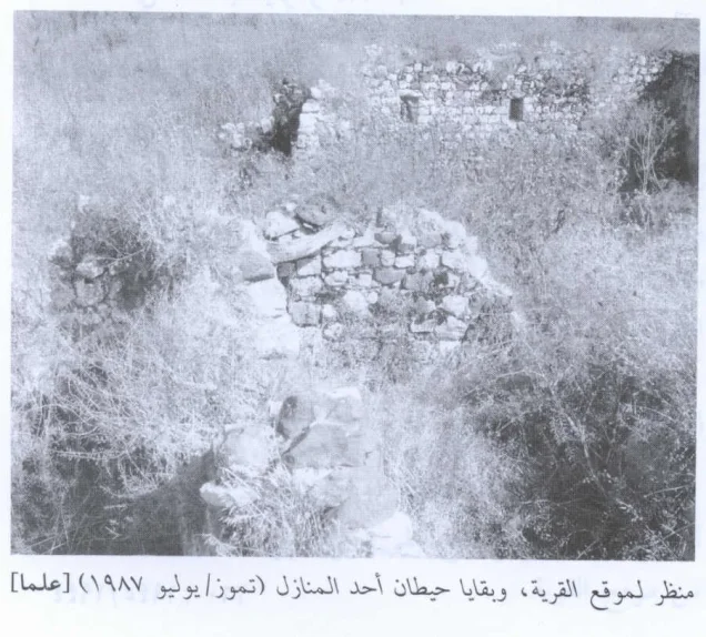
Most buildings were demolished, leaving rubble and limited sections of standing stone walls.
Refugees from 'Alma
Palestine Remembered estimates the village population in 1948 at approximately 1,102. This is a later demographic estimate rather than an official Government of Palestine census figure.
The same source estimates that refugees from 'Alma and their descendants numbered approximately 6,767 in 1998.
Community documentation records villagers and descendants in Lebanon and elsewhere, but the core sources do not provide a complete official distribution of every displaced family, so no single destination is assigned to the whole population.
Israeli Settlements on 'Alma Village Lands
The Israeli settlement of 'Alma was established in 1949 on the lands of the Palestinian village.
It lies approximately half a kilometer east of the former village site.
The use of the same place-name should not be confused with continuity of the Palestinian village community: the original inhabitants had been expelled and were not permitted to return, while a new settlement was established on their lands.
'Alma Today
In Walid Khalidi's field description, the village site was fenced and contained the rubble of former houses covered with thorny grasses.
A truncated stone wall containing a doorway and two windows still stood.
Israeli farmers had planted fruit trees on the surrounding village lands.
This description does not constitute direct field verification of conditions in 2026. Field research for All That Remains was carried out between 1987 and 1990.
Palestine Remembered also contains later community photographs from 2003 showing house remains, olive trees, and other traces at the site. These materials are useful for documenting later conditions but do not constitute a comprehensive contemporary cadastral and field survey of all former village lands.
Sources
- PalQuestPalQuest – 'Alma
- PalQuestPalQuest – Operation Hiram
- Palestine RememberedPalestine Remembered – 'Alma, Safad District
- Palestine RememberedPalestine Remembered – 'Alma entry from Walid Khalidi's All That Remains
- Institute for Palestine StudiesInstitute for Palestine Studies – Walid Khalidi, All That Remains
- pcbs.gov.psGovernment of Palestine – Census of Palestine 1922; source for the corrected 1922 population
- pcbs.gov.psPalestinian Central Bureau of Statistics – Historical Census Archive
- palqura.comPalestinian Villages Encyclopedia – 'Alma; supplementary documentation on boundaries, water, education, and village life
- PalQuestPalQuest – All That Remains: Methodology and Field Research
Photo gallery


Photos from the village's people
Photos sent in by visitors and published after review.
Add a photo of this village
Log in to add photos of this village.
Other villages from Safed


More from the archive



 Download Our Palestine App
The whole archive in the palm of your hand: depopulated villages, the Nakba, the massacres and Al-Aqsa — free, with no ads to erase the story.
Download Our Palestine App
The whole archive in the palm of your hand: depopulated villages, the Nakba, the massacres and Al-Aqsa — free, with no ads to erase the story.



Comments
No comments yet — be the first to write one.
Add your comment
Name and email are optional. Comments appear after review.