
The depopulated village of Jubb Yusuf / District of Safed

Jubb Yusuf
About the depopulated village of Jubb Yusuf
- District
- Safed
- Date Jubb Yusuf was occupied
- 04 May 1948
- Population in 1948
- 197
- Military operation
- Operation Yiftach
- Brigade that carried it out
- Not identified in the sources; the Haganah launched Operation Yiftach under Yigal Allon (Yiftach Brigade), spearheaded by the Palmach's First Battalion
- Distance from the governorate centre
- 6 km southeast of Safad
- Elevation above sea level
- 250 m
- Cause of displacement
- Probable expulsion by Zionist forces when the village was attacked on 4 May 1948
- Extent of destruction
- The village has been completely destroyed with the exception of al-Shaykh 'Abdallah shrine.
- Ethnic cleansing
- Jubb Yusuf inhabitants were completely ethnically cleansed.
- Settlements built on the land of Jubb Yusuf before 1948
- 'Ammi'ad, established in 1946 on village land north of the village site
Hover a dot to read the village name, or click to open its card.
Borders of the depopulated village of Jubb Yusuf
Jubb Yusuf: A Depopulated Palestinian Village in the Safad District
Jubb Yusuf, also known as 'Arab al-Suyyad, was a Palestinian village in the Safad District. It stood approximately 6 km southeast of Safad on a flat volcanic plain with reddish soil, northwest of Lake Tiberias, at an average elevation of about 250 metres above sea level. Its Palestinian inhabitants were displaced during the Nakba and the occupation of Palestine in 1948. The village was attacked on 4 May in the context of Operation Yiftach, and the account reproduced by Walid Khalidi indicates that its residents were probably expelled at that time.
- Subdistrict
- Safad
- Distance from district center
- 6 km southeast of Safad
- Average Elevation
- 250 m above sea level
- Population in 1931
- 93
- Number of Houses in 1931
- 17
- Population in 1944/1945
- 170
- Estimated Population in 1948
- About 197 – a later demographic estimate, not an official census
- Total Land Area in 1945
- 11,325 dunams
- Attack and Depopulation
- Zionist forces attacked the village on 4 May 1948, during Operation Yiftach, and its inhabitants were probably expelled at that time, according to Israeli historian Benny Morris as cited by Khalidi. On 22 April 1948, Palmach commander Yigal Allon had recommended an attempt to clear out the Bedouin encamped between the Jordan River, Jubb Yusuf and Lake Tiberias.
- Final Israeli Control
- 4 May 1948, when Zionist forces attacked the village and its inhabitants were probably expelled, according to Morris as cited by Khalidi; the available sources give no other date for its occupation
- Military Operation
- Operation Yiftach
- Military Unit
- The available sources do not identify the unit that attacked the village; the Haganah launched Operation Yiftach under Palmach commander Yigal Allon, PalQuest lists the Yiftach Brigade as its unit, and the Palmach's First Battalion spearheaded it
- Cause of Depopulation
- Probable expulsion by Zionist forces when the village was attacked on 4 May 1948
- Settlements Documented on Village Lands
- 'Ammi'ad, established in 1946 on village land north of the village site
Location of Jubb Yusuf
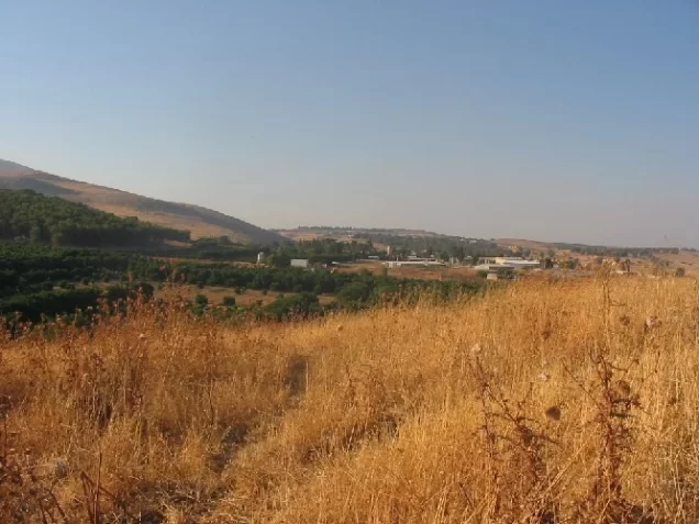
Jubb Yusuf stood on a flat volcanic plain with reddish soil northwest of Lake Tiberias.
The village was approximately 6 km southeast of Safad and had an average elevation of about 250 metres above sea level.
The main road linking Safad and Tiberias passed a short distance east of the village.
Its lands bordered or lay near those of al-Zanghariyya, 'Arab al-Samakiyya, al-Qudayriyya, and al-Zahiriyya al-Fawqa, while 'Akbara and al-Ja'una lay farther to the north and northwest.
The Name Jubb Yusuf and Khan Jubb Yusuf
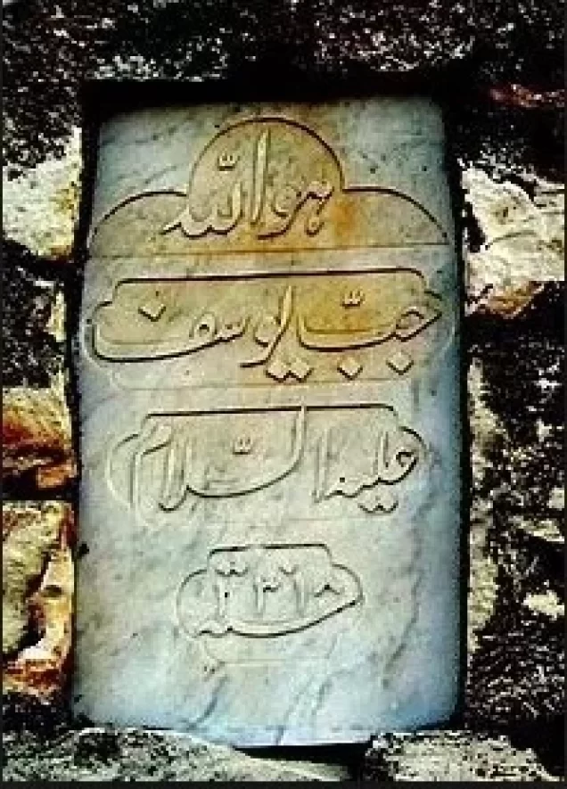
Walid Khalidi suggests that the village may have taken its name from the nearby well known as Jubb Yusuf.
In Arabic, jubb means a deep well or pit. Local religious tradition associated this particular well with the prophet Joseph.
The principal sources used here do not provide conclusive historical or archaeological evidence establishing the well as the actual biblical/Qur'anic well of Joseph. The association is therefore treated as a local tradition rather than a verified archaeological identification.
The locality was also known as Khan Jubb Yusuf because it had long served as a stopping place for travellers and caravans on the historic route toward Damascus.
Jubb Yusuf through History
The Arab geographer al-Muqaddasi referred to the site in 985 CE as a stopping place on the road to Damascus.
Salah al-Din al-Ayyubi also stopped in the area on his way to confront the Crusaders at the Battle of Hittin in 1187.
In 1355, Ibn Battuta described the well as large and deep and located within the courtyard of a small mosque.
In 1596, Jubb Yusuf was a village in the nahiya of Jira within the liwa of Safad, with an estimated population of approximately 72.
The villagers paid taxes on wheat, barley, and fruit, as well as goats and beehives.
In the late seventeenth and early eighteenth centuries, 'Abd al-Ghani al-Nabulsi described the dome over the well, the nearby mosque, and a substantially constructed khan.
Swiss traveller Johann Ludwig Burckhardt recorded in 1822 that the khan had begun to fall into ruin.
Architecture of Jubb Yusuf
The modern village was small and its houses stood close together.
The dwellings were built of mud, basalt stone, or limestone.
The village had a mosque surmounted by a dome.
It also contained the domed tomb of a local religious figure known as Shaykh 'Abdallah.
Palestine Remembered's automated summary includes an uncorroborated church entry. Khalidi, however, describes the entire village population as Muslim and documents a mosque but not a church. A church is therefore not presented here as an established feature of the village.
Water Supply
A number of wells and springs were available around Jubb Yusuf.
The villagers used this water for household needs and for irrigation.
The availability of water attracted the Bedouin 'Arab al-Suyyad tribe, whose members settled in the area, cultivated the land, and eventually formed the majority of the village population.
'Arab al-Suyyad and the Village Population
Most residents of modern Jubb Yusuf belonged to 'Arab al-Suyyad, a Bedouin community that settled near the local springs and cultivated the surrounding lands.
According to Khalidi, the village population was entirely Muslim.
Over time the community became increasingly settled, building houses and cultivating the lands around the village.
Education in Jubb Yusuf
The principal approved sources used here do not provide sufficiently documented information concerning an independent school in Jubb Yusuf before the Nakba.
No unverified educational details are therefore added.
Economic Life in Jubb Yusuf
Agriculture was the principal documented source of livelihood.
Cereals, especially wheat and barley, were important crops, alongside vegetables, fruit, and olives.
In 1944/45, 2,477 dunums of village land were devoted to cereal cultivation.
Nearby wells and springs supplied water for household use and for some irrigation.
Goats and beehives appear in the Ottoman tax records of 1596 as taxable resources. The principal source does not provide sufficient evidence to treat them as quantitatively important sectors of the village economy in 1945, so the Ottoman information is kept distinct from the description of the modern economy.
Land Ownership in Jubb Yusuf
The total registered land area of Jubb Yusuf was 11,325 dunums in the 1944/45 statistics.
Land ownership in Jubb Yusuf, 1944/45, using the terminology of Palestine Remembered
- Palestinian11,230 dunums99%
- Transferred to Zionists0 dunums0%
- Communal95 dunums<1%
No land was recorded in the category “Transferred to Zionists” in the 1944/45 ownership statistics.
Land Use in Jubb Yusuf, 1944/45
Land use in Jubb Yusuf, separating ownership categories according to PalQuest's detailed statistics
- Palestinian
- Communal/Public
- Cereals2,477 dunums
- Non-cultivable land8,848 dunums
A total of 2,477 dunums, approximately 22 percent of Jubb Yusuf's lands, was cultivated or cultivable.
Non-cultivable land amounted to 8,848 dunums, approximately 78 percent of the total: 8,753 Palestinian dunums and 95 communal/public dunums.
Palestine Remembered places all 8,848 dunums of non-arable land in its Palestinian column, whereas PalQuest's detailed table separates 95 dunums as public land. The communal/public category is therefore shown separately above.
PalQuest's detailed land-use table does not provide a separate built-up-area figure for Jubb Yusuf, so no unsupported built-up acreage is added.
Population of Jubb Yusuf
Population of Jubb Yusuf in selected years
- 159672Estimate derived from Ottoman records
- 192259Official British Mandate census
- 193193Official British Mandate census
- 1944/45170Official statistics
- 1948197Later estimate published by Palestine Remembered
- Estimated refugees in 19981,211Later estimate published by Palestine Remembered
Number of Houses in Jubb Yusuf
Number of houses in Jubb Yusuf
- 193117Official British Mandate census
- 194836Later estimate published by Palestine Remembered
Historical and Archaeological Features
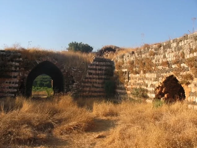
Khan Jubb Yusuf was one of the site's most important historical landmarks and was associated for centuries with travellers and caravans moving along the Damascus route.
The well itself was also a famous landmark and was described by medieval travellers.
The domed tomb of Shaykh 'Abdallah was another important feature of the village and survived the Nakba.
Khalidi records several khirbas to the east without naming all of them.
Palestine Remembered provides a more detailed list that includes al-'Ukayma, al-Shubbak, al-Tibaq, al-Khati, al-Rumayyat, al-Tum, 'Abbas, and Khirbat Khan al-Basha. These specific names are attributed to Palestine Remembered because they are not all listed in Khalidi's principal entry.
Clashes near Jubb Yusuf before its Occupation
The area south of Jubb Yusuf witnessed fighting during the first weeks of 1948.
On 12 February, units of the Arab Liberation Army engaged a Jewish military convoy south of the village, and British forces intervened to stop the fighting.
A similar clash occurred on 26 February, again followed by British intervention.
The account is based on the memoirs of Arab Liberation Army commander Fawzi al-Qawuqji as cited by Khalidi.
Operation Yiftach and Jubb Yusuf
Operation Yiftach began on 15 April 1948 and was conducted by Palmach forces with the objective of taking control of eastern Galilee before the end of the British Mandate.
The Palmach's First Battalion spearheaded the operation at the broader operational level, but the dedicated Jubb Yusuf entry does not identify the battalion that attacked the village itself.
In a report submitted to the Haganah General Staff on 22 April, Palmach commander Yigal Allon recommended an attempt to remove the Bedouin population living between the Jordan River, Jubb Yusuf, and the Sea of Galilee.
This Israeli document is not used independently here; it is included because it is reproduced and discussed in Khalidi/PalQuest.
Occupation and Depopulation of Jubb Yusuf during the Nakba
Walid Khalidi, citing Israeli historian Benny Morris, states that Jubb Yusuf itself was not attacked until 4 May 1948.
The same account considers it most likely that the inhabitants were expelled at that time.
Palestine Remembered likewise lists 4 May 1948 as the occupation date, associates the village with Operation Yiftach, and classifies the cause of depopulation as expulsion by Zionist forces.
This is consistent with the broader pattern of Operation Yiftach in eastern Galilee, where direct military assault, intimidation, psychological warfare, and post-occupation expulsions were used to depopulate Palestinian communities.
The principal village source does not identify the company or battalion that entered Jubb Yusuf itself. No specific sub-unit is therefore assigned without direct documentation.
- Earlier clashes near the village: 12 and 26 February 1948.
- Military operation associated with the depopulation: Operation Yiftach.
- Operation Yiftach began: 15 April 1948.
- Recommendation to remove Bedouin communities in the area: 22 April 1948.
- Date Jubb Yusuf was attacked: 4 May 1948.
- Probable cause of depopulation: expulsion during the attack; Palestine Remembered explicitly classifies it as expulsion.
- Village-specific military sub-unit: not established in the dedicated entry.
Occupation and Depopulation Chronology
- 12 and 26 February 1948
Clashes near the village
Units of the Arab Liberation Army clashed with military convoys of the Zionist forces south of Jubb Yusuf at least twice, and on both occasions British forces intervened to stop the fighting, according to the records of Arab Liberation Army commander Fawzi al-Qawuqji as cited by Khalidi.
- 15 April 1948; the second half of April 1948 according to the village entry
Beginning of the military operation
The Haganah launched Operation Yiftach to gain control of eastern Galilee; PalQuest's page on the operation dates its start to 15 April 1948, while the village entry says it was launched in the second half of April. PalQuest lists Jubb Yusuf among the villages affected by the operation.
- 22 April 1948
Recommendation to clear out the Bedouin around the village
In a report to the Haganah General Staff, Palmach commander Yigal Allon recommended 'an attempt to clear out the beduins encamped between the Jordan [River], and Jubb Yusuf and the Sea of Galilee', according to Morris as cited by Khalidi.
- 4 May 1948
Attack on the village and expulsion of its inhabitants
According to Israeli historian Benny Morris, as cited by Khalidi, the village itself was not attacked until 4 May, at which time its inhabitants were probably expelled. The available sources do not identify the unit that carried out the attack.
'Ammi'ad and the Lands of Jubb Yusuf
The settlement of 'Ammi'ad lies north of the former village site on land belonging to Jubb Yusuf.
'Ammi'ad was established in 1946, two years before the Nakba and the displacement of Jubb Yusuf's Palestinian inhabitants.
It should therefore be distinguished between the fact that the settlement stood on village land and the date of its establishment: 'Ammi'ad was not founded after Jubb Yusuf's 1948 depopulation.
- 'Ammi'ad: established in 1946 on Jubb Yusuf's lands, north of the village site.
Jubb Yusuf Today
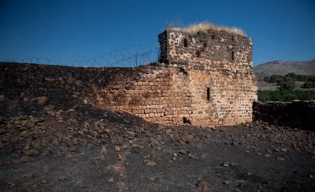
According to the field description published by Walid Khalidi in All That Remains, the thorn-covered khan and the domed tomb of Shaykh 'Abdallah were the principal structures remaining from the village.
Fig and carob trees grew on the site.
At the time of Khalidi's documentation, the village lands were cultivated by residents of 'Ammi'ad.
Structures associated with the regional water-diversion project were also present nearby, including pumping facilities in the al-Tabigha area approximately 6 km to the south on Lake Tiberias.
Palestine Remembered preserves later user-contributed documentation of Jubb Yusuf. This includes photographs dated June 2025 showing portions of the site and its surviving remains, as well as a short filmed visit published on 7 August 2026.
Palestine Remembered itself cautions that user-submitted articles, videos, and contributions express the views of their contributors and are not guaranteed to be fully accurate. These materials therefore do not constitute a systematic independent archaeological or field survey.
The principal site description above continues to rely on Khalidi's historical field research, supplemented cautiously by later user-contributed documentation. The approved sources used here do not provide a sufficiently comprehensive independent 2026 field survey to verify the precise condition of every part of Jubb Yusuf today.
Sources
- PalQuestPalQuest – Interactive Encyclopedia of the Palestine Question: Jubb Yusuf
- PalQuestPalQuest – Operation Yiftach
- Palestine RememberedPalestine Remembered – Jubb Yusuf, Safad District
- Palestine RememberedPalestine Remembered – Jubb Yusuf entry from All That Remains
- Institute for Palestine StudiesInstitute for Palestine Studies – All That Remains, Walid Khalidi
Photo gallery




Photos from the village's people
Photos sent in by visitors and published after review.
Add a photo of this village
Log in to add photos of this village.


More from the archive



 Download Our Palestine App
The whole archive in the palm of your hand: depopulated villages, the Nakba, the massacres and Al-Aqsa — free, with no ads to erase the story.
Download Our Palestine App
The whole archive in the palm of your hand: depopulated villages, the Nakba, the massacres and Al-Aqsa — free, with no ads to erase the story.



Comments
No comments yet — be the first to write one.
Add your comment
Name and email are optional. Comments appear after review.