
The depopulated village of Iraq al-Manshiyya / District of Gaza
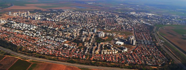
Iraq al-Manshiyya
About the depopulated village of Iraq al-Manshiyya
- District
- Gaza
- Date Iraq al-Manshiyya was occupied
- 01 March 1949
- Population in 1948
- 2,330
- Military operation
- Operation Yoav
- Brigade that carried it out
- Alexandroni Brigade
- Who defended the village
- Egyptian Army
- Distance from the governorate centre
- 32 (km) North East of Gaza
- Elevation above sea level
- 125 m
- Cause of displacement
- Expulsion by Zionist troops
- Extent of destruction
- 'Iraq al-Manshiyya inhabitants were completely ethnically cleansed.
- Ethnic cleansing
- The village was obliterated.
- Settlements built on the land of Iraq al-Manshiyya before 1948
- Gat, founded in 1941.
- Settlements built on the built-up area of Iraq al-Manshiyya after 1948
- Qiryat Gat, established in 1954, and Sde Moshe, established in 1956 east of the village site.
Hover a dot to read the village name, or click to open its card.
Borders of the depopulated village of Iraq al-Manshiyya
Iraq al-Manshiyya: A Depopulated Palestinian Village in the Gaza District
Iraq al-Manshiyya was a Palestinian village in the Gaza District whose inhabitants were displaced during the Nakba. The village resisted several Zionist military attacks during the occupation of Palestine in 1948, before its population was ultimately displaced following the Egyptian-Israeli Armistice Agreement of 1949. It was located approximately 32 kilometres northeast of Gaza City, where the coastal plain meets the western foothills of the Hebron hills, at an average elevation of about 125 metres above sea level.
- Subdistrict
- Gaza
- Distance from district center
- 32 km North East of Gaza
- Average Elevation
- 125 meters above sea level
- Population in 1931
- 1,347 inhabitants - Official census
- Number of Houses in 1931
- 299 houses - Official census
- Population in 1944/1945
- 2,220 inhabitants - Government of Palestine statistics: 2,010 Arabs and 210 Jews
- Estimated Population in 1948
- 2,332 inhabitants - a later demographic estimate, not an official census
- Total Land Area in 1945
- 17,901 dunams
- Attack and Depopulation
- The village withstood several attacks in 1948, then its inhabitants were subjected to pressure and intimidation after the Rhodes Armistice of 24 February 1949, and their expulsion was completed in the following days
- Final Israeli Control
- 24 February-1 March 1949
- Military Operation
- Operation Yoav
- Military Unit
- Alexandroni Brigade
- Cause of Depopulation
- Expulsion by Zionist troops
- Settlements Documented on Village Lands
- Qiryat Gat, established in 1954, and Sde Moshe, established in 1956 east of the village site.
Location and Name
Under the administrative divisions of Palestine during the British Mandate, Iraq al-Manshiyya belonged to the Gaza District. It stood in an area of gently rising hills, with Wadi Fattala to the west, and lay south of the main road connecting al-Faluja to the northwest with Bayt Jibrin to the east. The lands of al-Faluja, Zayta, Bayt Jibrin, and the territories of the al-Jabarat tribe in the Beersheba region bordered or lay near the village lands.
The village name reflected its geography and local history. The word "Iraq" is derived from the Arabic word "irq," which can refer to a ridge or small hill, while "al-Manshiyya" was added to distinguish the village from another nearby locality also known as Iraq.
The village occupied an important position because it was connected to a network of roads leading toward al-Faluja, Bayt Jibrin, Gaza, and southern Palestine.
Iraq al-Manshiyya Through History
Historical records indicate that in 1596 Iraq al-Manshiyya was a village in the Gaza subdistrict of the Gaza district of the Ottoman Empire. Its recorded population was approximately 61 people, and taxes were levied on agricultural products and livestock, including wheat, barley, goats, and beehives.
By the late nineteenth century, most of the village houses were built of mud brick and were surrounded by cultivated land. The village had a roughly circular or radial layout, with small streets branching from the intersection of two main roads that formed its centre. Residents obtained water for domestic use from three wells.
As the village expanded, construction extended toward the main road and northeast toward Tall al-Shaykh Ahmad al-Urani, a large mound rising approximately 32 metres above its immediate surroundings. The shrine of Shaykh Ahmad al-Urani stood on its summit.
Population
The population of Iraq al-Manshiyya was 1,132 in the 1922 census and increased to 1,347 in the 1931 census. The 1931 census also recorded approximately 299 houses.
In the 1944/1945 Village Statistics, the population recorded within the statistical unit was 2,220, consisting of 2,010 Arabs and 210 Jews. This official figure should be distinguished from later estimates. Palestine Remembered gives an estimated population of 2,332 for 1948 and an estimated 14,319 refugees and descendants in 1998.
Population of Iraq al-Manshiyya
- 159661Historical figure reported in the sources
- 19221,132Official census
- 19311,347Official census
- 1944/19452,220Government of Palestine statistics: 2,010 Arabs and 210 Jews
- 19482,332Estimate published by Palestine Remembered
- 199814,319Estimate of refugees and their descendants
Number of Houses
Recorded and estimated number of houses in Iraq al-Manshiyya
- 1931299Official census
- 1948517Estimate published by Palestine Remembered
Land of Iraq al-Manshiyya
According to the 1944/1945 statistics, the total registered land area of Iraq al-Manshiyya amounted to 17,901 dunams, equivalent to approximately 17.901 square kilometres. Arabs owned 13,838 dunams, Jews owned 3,468 dunams, and 595 dunams were classified as public land. PalQuest notes that these land statistics include Gat.
Land ownership in Iraq al-Manshiyya in 1944/1945
- Arab ownership13,838 dunums77%
- Jewish ownership3,468 dunums19%
- Public land595 dunums3%
Land Use and Agriculture
The economy of Iraq al-Manshiyya depended primarily on agriculture, particularly the cultivation of cereals, grapes, olives, almonds, and other fruit trees. Most agriculture was rain-fed, especially along the zone where the coastal plain met the western foothills.
According to the detailed 1944/1945 land-use figures published by PalQuest, 13,449 dunams of Arab-owned land were devoted to cereals, along with 3,433 dunams of Jewish-owned land and 14 dunams of public land, bringing the total area devoted to cereals to 16,896 dunams. A further 53 dunams of Arab-owned land were irrigated or used for plantations.
Land use in Iraq al-Manshiyya in 1944/1945, in dunams
- Arab
- Jewish
- Public
- Cereals16,896 dunums
- Irrigated and plantation land53 dunums
- Built-up area204 dunums
- Uncultivable land748 dunums
The inhabitants also raised goats and sheep, which supplied wool and yarn used in weaving rugs. Villagers sent rugs to nearby al-Faluja for dyeing and also relied on al-Faluja for medical care and some other services.
Education and Religious Life
Iraq al-Manshiyya had an older mosque as well as a newer mosque. The newer mosque contained several rooms, a portico, and a courtyard.
An elementary school for boys was established in 1934, and by the mid-1940s it had 201 pupils. The Arabic version of the text from Walid Khalidi's All That Remains reproduced by Palestine Remembered contains a reference to 1943 in one passage. However, PalQuest, the statistical material on Palestine Remembered, and the English version of the same text agree on 1934; accordingly, 1934 has been adopted here.
Tall al-Shaykh Ahmad al-Urani and Archaeology
Tall al-Shaykh Ahmad al-Urani stood north of the village, with the shrine of Shaykh Ahmad al-Urani located on its summit. The mound contains the remains of an ancient archaeological site.
Sources indicate that the mound was for many years incorrectly identified with the ancient Philistine city of Gath. Archaeological excavations conducted between 1956 and 1961, followed by additional work in 1984, did not establish evidence supporting that identification. The excavations indicated that settlement at the mound dated back to the fourth millennium BCE and that the site was inhabited intermittently until approximately the second century BCE.
These archaeological findings do not, by themselves, justify applying modern national or ethnic identities to ancient populations. For this reason, unsupported claims of that kind have not been included.
The Nakba and Attempts to Occupy Iraq al-Manshiyya
Iraq al-Manshiyya was among the Palestinian villages that resisted several Zionist military attempts to capture it during the Nakba and the occupation of Palestine in 1948. Egyptian forces were deployed in and around the village and participated in its defence.
Attempt by the Givati Brigade
PalQuest, drawing on sources including Palestinian historian Arif al-Arif, states that the Givati Brigade attempted to capture Iraq al-Manshiyya in late July 1948 during the second truce but failed. Arif al-Arif also records that the village remained a target of repeated attacks during this period, including an attack on 22 August.
Operation Yoav
Operation Yoav began on 15 October 1948 and involved the Givati, Yiftach, Negev, and Harel brigades. On 16 October, Israeli forces launched a major attack against Iraq al-Manshiyya. An armoured force succeeded in entering the village, but Egyptian troops repelled the attack and forced the attacking forces to withdraw.
It is therefore inaccurate to state that Iraq al-Manshiyya was permanently occupied during Operation Yoav. The operation included a major attempt to capture the village, but that attempt failed.
Attack by the Alexandroni Brigade
On 27-28 December 1948, units of the Alexandroni Brigade launched another attack and succeeded in entering Iraq al-Manshiyya. Egyptian reinforcements subsequently arrived and expelled the attacking forces from the village.
Iraq al-Manshiyya and al-Faluja consequently remained within what became known as the Faluja Pocket, where approximately 3,000 Palestinian civilians and a brigade of the Egyptian army were surrounded. Gamal Abdel Nasser, who later became president of Egypt, was among the Egyptian officers serving in the pocket.
The 1949 Armistice Agreement and the Displacement of the Population
Egypt and Israel signed the General Armistice Agreement on Rhodes on 24 February 1949. The correspondence associated with the agreement explicitly provided that civilians in al-Faluja and Iraq al-Manshiyya who wished to remain were entitled to do so, while those who wished to leave could depart under United Nations supervision. The agreement also provided for the protection of civilian lives, homes, property, and personal belongings.
Despite these provisions, the Palestinian inhabitants of Iraq al-Manshiyya did not remain in their village. PalQuest, in its presentation of Walid Khalidi's research and while citing information attributed to Israeli historian Benny Morris, reports that intimidation and pressure were used after the armistice agreement to induce between 2,000 and 3,000 residents of Iraq al-Manshiyya and al-Faluja to leave. PalQuest also reports that the United Nations mediator received accounts of Israeli soldiers beating civilians, looting property, and reports of attempted rape.
This information is included here because it is reported by PalQuest within the Palestinian sources being used, rather than through direct reliance on an Israeli source.
Date of Final Occupation and Displacement
Palestine Remembered gives 1 March 1949 as the date on which Iraq al-Manshiyya was occupied and its inhabitants displaced. PalQuest does not identify the final evacuation with the same single-day precision, instead placing the depopulation of the village in the period immediately following the signing of the armistice agreement on 24 February 1949. Accordingly, 1 March 1949 is presented here as the date given by Palestine Remembered, while noting the difference in precision between the sources.
The displacement of Iraq al-Manshiyya, therefore, extended beyond 1948 into 1949. Its inhabitants were ultimately forced from the village after several earlier military attempts to capture it permanently had failed.
Fate of the Population and Buildings
The Palestinian inhabitants of Iraq al-Manshiyya were displaced and became refugees and internally displaced Palestinians. After the village was emptied, most of its built-up area was destroyed. According to the field documentation reproduced in the reviewed sources, only traces of some streets, scattered cactus plants, and limited remains of the village were still visible.
Occupation and Depopulation Chronology
- Not specified precisely
The Nakba and Attempts to Occupy Iraq al-Manshiyya
Iraq al-Manshiyya was among the Palestinian villages that resisted several Zionist military attempts to capture it during the Nakba and the occupation of Palestine in 1948. Egyptian forces were deployed in and around the village and participated in its defence.
- July 1948
Attempt by the Givati Brigade
PalQuest, drawing on sources including Palestinian historian Arif al-Arif, states that the Givati Brigade attempted to capture Iraq al-Manshiyya in late July 1948 during the second truce but failed. Arif al-Arif also records that the village remained a target of repeated attacks during this period, including an attack on 22 August.
- 15 October 1948
Operation Yoav
Operation Yoav began on 15 October 1948 and involved the Givati, Yiftach, Negev, and Harel brigades. On 16 October, Israeli forces launched a major attack against Iraq al-Manshiyya.
- 27-28 December 1948
Attack by the Alexandroni Brigade
On 27-28 December 1948, units of the Alexandroni Brigade launched another attack and succeeded in entering Iraq al-Manshiyya. Egyptian reinforcements subsequently arrived and expelled the attacking forces from the village.
- 1 March 1949
Date of Final Occupation and Displacement
Palestine Remembered gives 1 March 1949 as the date on which Iraq al-Manshiyya was occupied and its inhabitants displaced. PalQuest does not identify the final evacuation with the same single-day precision, instead placing the depopulation of the village in the period immediately following the signing of the armistice agreement on 24 February 1949.
Israeli Settlements Established on the Lands of Iraq al-Manshiyya
Gat
Kibbutz Gat was established in 1941 on land that had traditionally belonged to Iraq al-Manshiyya. Following the displacement of the Palestinian inhabitants in 1949, the kibbutz took control of additional village land.
Kiryat Gat
Kiryat Gat was established in 1954 on land belonging to Iraq al-Manshiyya.
Sde Moshe
Sde Moshe was established in 1956 on village land, east of the original village site.
- Gat, established in 1941 on land traditionally belonging to the village.
- Kiryat Gat, established in 1954 on village land.
- Sde Moshe, established in 1956 on village land.
The Site of Iraq al-Manshiyya Today
According to the description reproduced by PalQuest from Walid Khalidi's field documentation, a eucalyptus forest was planted on the village site. Two signs, in Hebrew and English, identified the area as the "Margolin Peace Forest."
At the time of that documentation, only traces of some village streets and scattered cactus plants remained, while parts of the surrounding land were used for agriculture. This description reflects the period in which the original field documentation was conducted and should not be interpreted as a field survey of the site in 2026.
Sources
- PalQuest – Interactive Encyclopedia of the Palestine Question: Iraq al-Manshiyya.
- PalQuest: Operation Yoav.
- PalQuest and the Institute for Palestine Studies: Egyptian-Israeli General Armistice Agreement, 24 February 1949.
- Palestine Remembered: Iraq al-Manshiyya, Gaza District.
- Palestine Remembered: Government of Palestine Village Statistics, 1945.
- Walid Khalidi, All That Remains, entry on Iraq al-Manshiyya, as reproduced and cited by PalQuest and Palestine Remembered.
- Arif al-Arif, Al-Nakba: Nakbat Bayt al-Maqdis wal-Firdaws al-Mafqud, particularly his account of the battles around Iraq al-Manshiyya and the Faluja Pocket, as cited by the Palestinian sources listed above.
Photo gallery


Photos from the village's people
Photos sent in by visitors and published after review.
Add a photo of this village
Log in to add photos of this village.
Other villages from Gaza

More from the archive

 Download Our Palestine App
The whole archive in the palm of your hand: depopulated villages, the Nakba, the massacres and Al-Aqsa — free, with no ads to erase the story.
Download Our Palestine App
The whole archive in the palm of your hand: depopulated villages, the Nakba, the massacres and Al-Aqsa — free, with no ads to erase the story.



Comments
No comments yet — be the first to write one.
Add your comment
Name and email are optional. Comments appear after review.