
The depopulated village of Karatiyya / District of Gaza
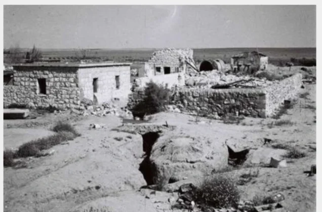
Karatiyya
About the depopulated village of Karatiyya
- District
- Gaza
- Date Karatiyya was occupied
- 18 July 1948
- Population in 1948
- 1,589
- Military operation
- Not named in the sources: the second of two Givati Brigade offensives on the southern front during the Ten Days between the truces (July 1948)
- Brigade that carried it out
- Givati Brigade، Ninth Commando Battalion
- Who defended the village
- Egyptian Army
- Distance from the governorate centre
- 29 km northeast of Gaza
- Elevation above sea level
- 100 m
- Cause of displacement
- Direct military assault by Israeli occupation forces, which led to the dispersal of the inhabitants
- Extent of destruction
- The village was completely destroyed and only house rubble left behind.
- Ethnic cleansing
- Karatiyya inhabitants were completely ethnically cleansed.
- Settlements built on the built-up area of Karatiyya after 1948
- Qomemiyyut, founded in 1950; Rewacha, established in 1953 close to the village site; Nehora, established in 1956 partly on village land and partly on lands belonging to al-Faluja
Hover a dot to read the village name, or click to open its card.
Borders of the depopulated village of Karatiyya
Karatiyya: A Depopulated Palestinian Village in the Gaza District
Karatiyya was a depopulated Palestinian village in the Gaza District, located approximately 29 kilometers northeast of Gaza, close to al-Faluja and the al-Faluja–al-Majdal road. The village stood on flat terrain in the southern coastal plain at an average elevation of approximately 100 meters above sea level. Wadi al-Mufrid, descending from al-Faluja to the east, crossed the southern and western edges of the village.
- Subdistrict
- Gaza
- Distance from district center
- 29 km northeast of Gaza
- Average Elevation
- 100 m above sea level
- Population in 1931
- 932
- Number of Houses in 1931
- 229
- Population in 1944/1945
- 1,370
- Estimated Population in 1948
- About 1,589 – a later demographic estimate, not an official census
- Total Land Area in 1945
- 13,709 dunams
- Attack and Depopulation
- The village was occupied on the night of 17–18 July 1948, just before the second truce took effect, in the second of two offensives launched by the Givati Brigade on the southern front during the Ten Days, an offensive that led to the dispersal of its inhabitants. Units from the Third Battalion of the Givati Brigade and from the Ninth Commando Battalion of the Armored Brigade took part, the latter 'storming' the village and occupying it, according to the History of the War of Independence as cited by Khalidi.
- Final Israeli Control
- Night of 17–18 July 1948, according to the History of the War of Independence as cited by Khalidi
- Military Operation
- Not named in the sources: the second of two operations launched by the Givati Brigade on the southern front during the Ten Days between the two truces of the war (July 1948); PalQuest does not list the village among those of Operation An-Far
- Military Unit
- The Ninth Commando Battalion of the Armored Brigade, which 'stormed' the village and occupied it, and units from the Third Battalion of the Givati Brigade, according to the History of the War of Independence as cited by Khalidi
- Cause of Depopulation
- Direct military assault by Israeli occupation forces, which led to the dispersal of the inhabitants
- Settlements Documented on Village Lands
- Qomemiyyut, founded in 1950; Rewacha, established in 1953 close to the village site; and Nehora, established in 1956 partly on village land and partly on lands belonging to al-Faluja
The Government of Palestine's 1944/1945 statistics recorded a population of 1,370 and a total land area of 13,709 dunums. During the Nakba and the occupation of Palestine in 1948, Karatiyya was occupied on the night of 17–18 July, immediately before the second truce came into effect. Forces involved included the Third Battalion of the Giv'ati Brigade and the Ninth Commando Battalion of the Armored Brigade, with the latter identified in the military account cited by Walid Khalidi as the force that stormed and occupied the village.
Key Facts About Karatiyya
- Subdistrict: Gaza.
- Distance from Gaza: approximately 29 kilometers northeast.
- Average elevation: approximately 100 meters above sea level.
- Population in 1944/1945: 1,370.
- Estimated population in 1948: 1,589 according to Palestine Remembered.
- Total land area: 13,709 dunums.
- Date of occupation: night of 17–18 July 1948; some Palestinian sources use 17 July as the specific date.
- Military context: the second Giv'ati offensive in the area during the Ten Days between the two truces, immediately after Operation An-Far.
- Military units: Third Battalion of the Giv'ati Brigade and Ninth Commando Battalion of the Armored Brigade.
- Opposing forces: Egyptian forces, which counterattacked after the village was occupied.
Location of Karatiyya
Karatiyya stood on flat ground in the southern coastal plain, approximately 29 kilometers northeast of Gaza. Palestinian local documentation places it about one kilometer northwest of al-Faluja.
Wadi al-Mufrid, descending from al-Faluja in the east, crossed the southern and western edges of the village, while the main al-Faluja–al-Majdal road passed immediately to the north.
The road and wadi shaped the village's physical expansion. New construction developed mainly northward and parallel to the road, while the wadi constrained expansion toward the south and west.
Neighboring Palestinian Villages
Karatiyya lay among several Palestinian villages in the northeastern part of the Gaza District, including:
- Al-Sawafir al-Sharqiyya to the north and northwest.
- Hatta to the northeast.
- Al-Faluja to the east and southeast.
- Bayt 'Affa in the northern and northwestern area.
- 'Iraq Suwaydan to the west.
- Zayta to the east.
The Name and Early History of Karatiyya
Sources differ concerning the origin of the name Karatiyya. Palestinian local documentation suggests that the name may have a Greek origin associated with the meaning “strength” or “rule.” This derivation, however, is not presented as established in Walid Khalidi's account and is therefore treated here as a local interpretation rather than a confirmed etymology.
A more securely documented historical connection concerns a Crusader castle called Galatie, constructed at the village site during the twelfth century and subsequently captured by Salah al-Din al-Ayyubi.
The Arab geographer Yaqut al-Hamawi, who died in 1228, mentioned the locality as Qaratiyya near Bayt Jibrin and associated it with the jurisdiction of Jerusalem.
In 1299, the Mamluk sultan al-Nasir Muhammad ibn Qalawun camped at Karatiyya while on campaign against the Mongols. Some Arabic reproductions shorten the ruler's name to “Qalawun,” but the chronologically correct identification is al-Nasir Muhammad ibn Qalawun.
Karatiyya During the Ottoman Period
In 1596, Karatiyya was recorded in the nahiya of Gaza within the liwa' of Gaza and had an estimated population of approximately 253.
The villagers paid taxes on wheat, barley, fruit, vineyards, goats, beehives, and other forms of agricultural production.
By the late nineteenth century, Karatiyya was described as standing in a broad open plain, with the ruins of a tower visible on a mound immediately outside the village.
The Built Environment of Karatiyya
Most houses in Karatiyya were constructed of adobe brick, and village expansion developed parallel to the al-Faluja–al-Majdal road passing to the north.
The built-up area covered approximately 48 dunums according to the 1944/1945 statistics.
Karatiyya contained a mosque, an elementary school, and a grain mill. The villagers relied on nearby al-Faluja for many medical, commercial, and administrative services.
Population of Karatiyya
The 1922 Census of Palestine recorded 736 inhabitants in Karatiyya, all Muslims.
By the 1931 census, the population had increased to 932, living in 229 houses.
The Government of Palestine's 1944/1945 statistics recorded 1,370 inhabitants.
The figures of 1,589 inhabitants for 1948 and 9,759 refugees for 1998 published by Palestine Remembered are later demographic estimates rather than official censuses.
Population of Karatiyya
- 1596About 253Historical estimate based on Ottoman tax records
- 1922736Official census
- 1931932Official census; living in 229 houses
- 1944/19451,370Government of Palestine statistics
- 19481,589Later estimate published by Palestine Remembered
- 19989,759Later refugee-population estimate published by Palestine Remembered
Number of Houses in Karatiyya
The 1931 Census of Palestine recorded 229 houses in Karatiyya.
The figure of 390 houses for 1948 published by Palestine Remembered is a later estimate rather than an official census figure.
Number of Houses in Karatiyya
- 1931229Official census
- 1948390Later estimate published by Palestine Remembered
Education in Karatiyya
Karatiyya had a mosque and an elementary school established in 1922.
By the mid-1940s, the school enrolled approximately 128 pupils.
Despite these local institutions, nearby al-Faluja remained the principal center on which the villagers depended for many administrative, medical, and commercial services.
Water Sources in Karatiyya
Domestic water was supplied by two wells dug within the village.
Wadi al-Mufrid was one of the principal natural features associated with Karatiyya, crossing its southern and western edges.
Palestinian local documentation also records smaller seasonal wadis and drainage channels associated with village lands, including Wadi al-Ghuwayt and Wadi al-Sidr.
Land Ownership in Karatiyya
The Government of Palestine's 1944/1945 statistics recorded a total land area of 13,709 dunums for Karatiyya.
Arab ownership accounted for 13,346 dunums, while 363 dunums were classified as public land. No Jewish land ownership was recorded.
The Arabic Palestine Remembered table uses the categories “Palestinian,” “Transferred to Zionists,” and “Masha'.” These terms are preserved below as that source's terminology.
Land Ownership in Karatiyya, 1944/1945, Using Palestine Remembered Terminology
- Palestinian13,346 dunums97%
- Transferred to Zionists0 dunums0%
- Masha' (source terminology)363 dunums3%
Land Use in Karatiyya in 1944/1945
Karatiyya was intensively agricultural. A total of 13,249 dunums, approximately 97 percent of its lands, were cultivated or classified as cultivable, all of them recorded as Arab land.
Cereals occupied 12,928 dunums, while plantations and irrigable land covered 321 dunums.
The built-up area covered 48 dunums of Arab land. Non-cultivable land totaled 412 dunums, consisting of 49 dunums of Arab land and 363 dunums of public land.
Land Use in Karatiyya According to the 1944/1945 Statistics
- Arab
- Jewish
- Public
- Plantations and Irrigable Land321 dunums
- Cereals12,928 dunums
- Built-up Area48 dunums
- Non-Cultivable Land412 dunums
Economic Life in Karatiyya
Rainfed agriculture formed the foundation of Karatiyya's economy, and cereal production dominated the cultivated landscape.
The villagers also cultivated fruit trees on smaller areas, while prickly pears were another familiar agricultural product.
A grain mill operated in the village, reflecting the importance of wheat and barley production.
For marketing produce and obtaining many commercial, medical, and administrative services, the villagers relied heavily on nearby al-Faluja.
Archaeological Remains in Karatiyya
The remains in Karatiyya indicate the historical importance of the site across several periods.
A Crusader castle known as Galatie was constructed there during the twelfth century and later passed into Ayyubid control.
By the late nineteenth century, a ruined tower still stood on a mound immediately outside the village.
The village lands also contained khirbas and remains associated with the Crusader and Mamluk periods.
Military Context Before the Occupation of Karatiyya
The area between al-Majdal, al-Faluja, and Bayt Jibrin witnessed extensive fighting in July 1948 during the Ten Days separating the first and second truces.
Between 8 and 15 July, the First Battalion of the Giv'ati Brigade carried out Operation An-Far, occupying and depopulating several Palestinian villages. The operation, however, failed to achieve its principal objective of establishing a continuous link with Zionist-held areas in the Negev.
Military operations continued after An-Far ended, and Giv'ati launched another offensive immediately before the second truce. Karatiyya was among the villages targeted during this subsequent phase.
The occupation of Karatiyya itself should therefore not be classified as part of Operation An-Far, because the village was captured on 17–18 July, after An-Far had ended on 15 July.
The Occupation of Karatiyya on 17–18 July 1948
Karatiyya was occupied on the night of 17–18 July 1948, only hours before the second truce came into effect.
According to Walid Khalidi and PalQuest, the attacking forces included units from the Third Battalion of the Giv'ati Brigade and the Ninth Commando Battalion of the Armored Brigade.
The military account cited by Khalidi identifies the Ninth Commando Battalion as the force that stormed and occupied the village.
Palestine Remembered and the Palestinian Villages Encyclopedia give 17 July as the specific occupation date, while Khalidi uses the more precise formulation of the night of 17–18 July.
Fighting with Egyptian Forces Around Karatiyya
After Israeli forces occupied Karatiyya, intense fighting took place with Egyptian forces that reached the outskirts of the village.
According to the military account transmitted through Walid Khalidi, Egyptian tanks attempted to advance from the south toward Israeli positions in the village and were confronted by anti-tank forces.
The second truce came into effect on the evening of 18 July, while nearby Egyptian positions continued to prevent the Israeli forces from establishing the desired direct corridor to the Negev.
The Egyptian-held area around al-Faluja and 'Iraq al-Manshiyya later became known as the Faluja Pocket.
Details originating in Israeli military documentation are presented here through the Palestinian intermediary sources Walid Khalidi and PalQuest rather than through independent reliance on Israeli sources.
The Displacement of Karatiyya's Inhabitants
The military assault and occupation of Karatiyya in July 1948 resulted in the displacement of its Palestinian population.
Palestine Remembered classifies the cause of depopulation as a military assault, while Walid Khalidi places Karatiyya within the wider series of Giv'ati attacks that displaced the inhabitants of numerous Palestinian villages during the Ten Days.
Palestinian local documentation states that most villagers moved toward Gaza and its refugee camps, while others went toward Hebron, the West Bank, and Jordan.
Occupation and Depopulation Chronology
- Night of 17–18 July 1948
Final occupation
In the second of two offensives launched by the Givati Brigade during the Ten Days, in which it tried to link its zone of control with that of Israeli occupation forces in the Negev, Karatiyya was occupied just before the second truce took effect; units from the Third Battalion of the Givati Brigade and from the Ninth Commando Battalion of the Armored Brigade took part, the latter 'storming' the village, according to the History of the War of Independence as cited by Khalidi. In this offensive the Givati Brigade occupied more territory in the Gaza subdistrict, leading to the dispersal of the inhabitants of several Palestinian villages, Karatiyya among them.
- 18 July 1948
Battle with Egyptian forces on the village outskirts
After the village was occupied, a fierce battle ensued with Egyptian forces who got as far as its outskirts, and an Israeli unit equipped with anti-tank weapons halted the advance of two Egyptian tanks from the south, according to the Haganah account as cited by Khalidi. At 7:00 p.m. that same evening the second truce took effect.
- Second half of October 1948
Failed attempt from the village to take the nearby Egyptian positions
Units of the Oded Brigade that had been sent to the southern front and were based in Karatiyya made an unsuccessful attempt to take the positions Egyptian forces had occupied just outside the village to block the road southwards. These positions came to be known as the 'Faluja pocket'.
- 1950
Settlement on village lands
The settlement of Qomemiyyut was founded on village lands.
- 1953
Settlement on village lands
The settlement of Rewacha was established on village lands, close to the village site.
- 1956
Settlement on village lands
The settlement of Nehora was established partly on village land and partly on lands belonging to al-Faluja.
The Oded Brigade at Karatiyya in October 1948
Several months after its occupation, Karatiyya acquired additional military significance in the confrontation with Egyptian forces in the al-Faluja area.
During the second half of October 1948, units of the Oded Brigade transferred to the southern front were based at Karatiyya.
They attempted unsuccessfully to capture nearby Egyptian positions.
This later role of the Oded Brigade should not be confused with the original occupation of Karatiyya in July, which was carried out by Giv'ati and armored forces.
Israeli Settlements on Karatiyya's Lands
Walid Khalidi and PalQuest identify three principal Israeli settlements associated with the lands of Karatiyya after the Nakba:
- Komemiyut: established in 1950 on the village lands.
- Revaha: established in 1953 near the former village site. Palestinian local documentation states that it was originally founded on the lands of Hatta and later expanded onto parts of Karatiyya's lands.
- Nehora: established in 1956 partly on Karatiyya's lands and partly on the lands of al-Faluja.
Palestinian local sources differ in some details concerning the precise boundaries of later settlements. This article therefore uses the Walid Khalidi/PalQuest list as its principal framework while noting locally documented differences where relevant.
Karatiyya After the Nakba
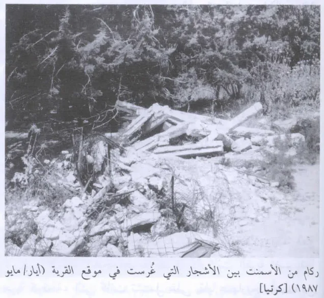
According to Walid Khalidi's historical field description in All That Remains, rubble from the village buildings was scattered across the site.
The ruined cemetery remained visible, partly hidden among eucalyptus trees, while an agricultural road crossed the former village site.
The lands of Karatiyya and the surrounding area were used for cultivating cereals and alfalfa.
Palestinian local documentation also records scattered stone remains, eucalyptus trees, and wild thorny vegetation at the site.
Khalidi's description derives from historical fieldwork undertaken for All That Remains and should not necessarily be treated as an updated field survey of the site in 2026.
Sources
- PalQuestPalQuest – Interactive Encyclopedia of the Palestine Question: Karatiyya
- PalQuestPalQuest – Interactive Encyclopedia of the Palestine Question: Operation An-Far
- Palestine RememberedPalestine Remembered: Karatiyya – Gaza District
- Palestine RememberedPalestine Remembered: Karatiyya in Walid Khalidi's All That Remains
- palqura.comPalestinian Villages Encyclopedia: Karatiyya
- pal48.psFilastunna: The Depopulated Village of Karatiyya
Photo gallery
Photos from the village's people
Photos sent in by visitors and published after review.
Add a photo of this village
Log in to add photos of this village.
Other villages from Gaza

More from the archive

 Download Our Palestine App
The whole archive in the palm of your hand: depopulated villages, the Nakba, the massacres and Al-Aqsa — free, with no ads to erase the story.
Download Our Palestine App
The whole archive in the palm of your hand: depopulated villages, the Nakba, the massacres and Al-Aqsa — free, with no ads to erase the story.



Comments
No comments yet — be the first to write one.
Add your comment
Name and email are optional. Comments appear after review.