
The depopulated village of Al-Muharraqa / District of Gaza
Al-Muharraqa
About the depopulated village of Al-Muharraqa
- District
- Gaza
- Date Al-Muharraqa was occupied
- 27 May 1948
- Population in 1948
- 670
- Military operation
- Operation Barak
- Brigade that carried it out
- Negev Brigade
- Distance from the governorate centre
- 14.5 (km) North East of Gaza
- Elevation above sea level
- 125 m
- Cause of displacement
- Military assault by Zionist troops
- Extent of destruction
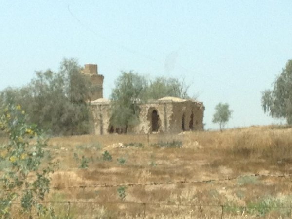
- The village has been mostly destroyed with the exception of its Diwan and its cemetery.
- Ethnic cleansing
- al-Muharraqa inhabitants were completely ethnically cleansed.
- Settlements built on the built-up area of Al-Muharraqa after 1948
- Yachini
Hover a dot to read the village name, or click to open its card.
Borders of the depopulated village of Al-Muharraqa
al-Muharraqa: A Depopulated Palestinian Village in the Gaza District
al-Muharraqa was a Palestinian village in the Gaza District, located approximately 14.5 km northeast of Gaza city on rolling terrain in the southern coastal plain, at an average elevation of about 125 metres above sea level. The village was attacked on 27–28 May 1948 and its inhabitants were expelled during the Nakba and the occupation of Palestine in 1948. It was apparently not completely destroyed and depopulated until 16 August 1948.
Location of al-Muharraqa
al-Muharraqa stood on rolling terrain at a bend in a wadi on the southern coastal plain. Secondary roads connected it with neighbouring villages and with the Gaza–Bir al-Sabi' highway.
The village lay approximately 14.5 km northeast of Gaza city and had an average elevation of about 125 metres above sea level. Kawfakha was one of its nearest neighbouring villages.
History of al-Muharraqa
During the Mamluk period, between 1250 and 1517, the lands of al-Muharraqa and the surplus from its agricultural production were endowed as waqf for the Dome of the Rock in Jerusalem and for another mosque in Gaza.
In 1596, al-Muharraqa was a village in the nahiya of Gaza within the liwa of Gaza, with an estimated population of approximately 457. It paid taxes on crops including wheat and barley, as well as on goats and beehives.
Walid Khalidi indicates that the sixteenth-century village was probably abandoned sometime during the seventeenth or eighteenth century, since travellers of those periods did not mention it. The site was most likely resettled in the late 1870s.
Architecture of al-Muharraqa
The village had an overall rectangular layout and continued to expand in a rectangular pattern along the roads leading to the main highway and to the neighbouring village of Kawfakha.
The inhabitants were Muslim, and most houses were constructed of adobe brick. The mosque, school, and several small shops formed the centre of the village.
Education in al-Muharraqa
A school opened in al-Muharraqa in 1945. Approximately 60 pupils were enrolled during the mid-1940s.
Economic Life in al-Muharraqa
Rainfed agriculture was the villagers' principal source of livelihood. Grain, particularly barley, was the main crop. During the final years of the British Mandate, residents also cultivated fig and almond trees and grapes.
Domestic water was obtained mainly from a well approximately 90 metres deep whose water was slightly salty. Rainwater collected in shallow household basins supplemented this supply.
According to the 1944/45 statistics, 12 dunums were irrigated or used for plantations, while 4,622 dunums of public or communal land were devoted to cereals.
Land Ownership in al-Muharraqa
The total land area of al-Muharraqa was 4,855 dunums according to the 1944/45 statistics. The village was unusual in that almost all of its recorded land area was classified as public land.
Land ownership in al-Muharraqa, 1944/45
- Arab12 dunums<1%
- Public4,843 dunums100%
Palestine Remembered presents the corresponding Arabic categories as 12 Palestinian dunums, zero dunums “transferred to Zionists,” and 4,843 dunums of communal land.
Land Use in al-Muharraqa, 1944/45
Land use in al-Muharraqa according to PalQuest
- Arab
- Public
- Plantations and irrigable land12 dunums
- Cereals4,622 dunums
- Built-up area29 dunums
- Non-cultivable land192 dunums
A total of 4,634 dunums, approximately 95 percent of the village lands, was classified as cultivated or cultivable. Built-up and non-cultivable land together amounted to 221 dunums.
Palestine Remembered presents these figures differently by placing the 4,622 dunums of cereal land in its Palestinian column. PalQuest's detailed table classifies those 4,622 dunums as public land, while the 12 Arab dunums were the irrigated or plantation area.
Population of al-Muharraqa
Population of al-Muharraqa in selected years
- 1596457Estimate derived from Ottoman records
- 1922204Official British Mandate census
- 1931422Official British Mandate census
- 1944/45580Official statistics
- 1948673Later estimate published by Palestine Remembered
- Estimated refugees in 19984,132Later estimate published by Palestine Remembered
Number of Houses in al-Muharraqa
Number of houses in al-Muharraqa
- 193186Official census figure
- 1948137Later estimate published by Palestine Remembered
Archaeological Remains in al-Muharraqa
Archaeological remains at al-Muharraqa included mosaic flooring, cisterns, and fragments of marble and pottery.
Although known Byzantine sources do not mention the village by name, the archaeological evidence indicates that the site was inhabited during the Byzantine period.
Occupation and Depopulation of al-Muharraqa during the Nakba
The Palmach's Negev Brigade attacked al-Muharraqa on 27–28 May 1948, at approximately the same time that it attacked the neighbouring village of Kawfakha. According to a New York Times report cited by Walid Khalidi, the village had been captured by 29 May.
Khalidi cites Israeli historian Benny Morris as stating that the inhabitants were driven out at that time. Morris is not used here as an independent source; his account is mentioned only because it is reproduced in the approved Palestinian reference.
The events of late May did not mark the final stage in the destruction of al-Muharraqa. Khalidi states that the village apparently did not become completely destroyed and depopulated until 16 August 1948, during the second truce.
According to the account reproduced by Khalidi, Israeli occupation forces mined and destroyed the village at that time for reasons described in the cited source as “military.”
Palestine Remembered categorizes the occupation of al-Muharraqa under Operation Barak and identifies the Negev Brigade as the attacking unit. PalQuest confirms that the Negev Brigade participated in Operation Barak and that a second stage of the offensive continued in southern Palestine after 15 May and through the end of that month.
However, PalQuest's dedicated entry for al-Muharraqa does not explicitly name Operation Barak, and the PalQuest page for the operation does not list al-Muharraqa among its affected villages. The association with Operation Barak is therefore attributed specifically to Palestine Remembered rather than presented as a point on which all sources agree.
- Date of attack: 27–28 May 1948.
- Capture according to the report cited by Khalidi: by 29 May 1948.
- Palestine Remembered occupation date: 27 May 1948.
- Documented attacking unit: the Palmach's Negev Brigade.
- Military operation: Palestine Remembered associates the attack with Operation Barak; Khalidi's dedicated PalQuest entry does not explicitly name the operation.
- Initial displacement: Khalidi cites an account stating that the inhabitants were expelled in late May.
- Complete destruction and depopulation: apparently 16 August 1948.
- Fate of the buildings: Israeli occupation forces mined and destroyed the village during the second truce according to the account reproduced in the approved source.
Settlements Established on the Lands of al-Muharraqa
Yakhini was established in 1950 on the lands of al-Muharraqa, north of the former village site.
Khalidi also cites Benny Morris as claiming that Tkuma, established in 1949, was built on al-Muharraqa's lands. Khalidi notes, however, that closer examination shows that Tkuma stands on land that formally belonged to the city of Gaza, even though it is only about 2 km west of the village site. Tkuma is therefore not listed here as a settlement established on al-Muharraqa's lands.
al-Muharraqa Today
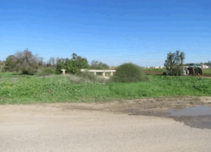
According to the field description published by Walid Khalidi in All That Remains, the village site was overgrown with thorny plants and short grasses and surrounded by eucalyptus trees.
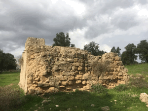
Piles of building rubble remained, including the ruins of the village diwan. The remains of a mill and a well were also visible. The village cemetery survived in a deteriorated condition beneath wild vegetation, and the upper structure of one tomb had fallen to the ground.
The surrounding lands were being cultivated.
This principal description derives from field research published in Khalidi's book in 1992. Palestine Remembered contains later user-contributed photographs of al-Muharraqa, including material dated 2013 showing the village well and other remains, but these contributions do not constitute a comprehensive independent field survey.
The approved sources used here therefore do not provide a sufficiently comprehensive and independent contemporary field verification of the precise condition of every part of the al-Muharraqa site in 2026.
Sources


Photos from the village's people
Photos sent in by visitors and published after review.
Add a photo of this village
Log in to add photos of this village.
More from the archive
 Download Our Palestine App
The whole archive in the palm of your hand: depopulated villages, the Nakba, the massacres and Al-Aqsa — free, with no ads to erase the story.
Download Our Palestine App
The whole archive in the palm of your hand: depopulated villages, the Nakba, the massacres and Al-Aqsa — free, with no ads to erase the story.



Comments
No comments yet — be the first to write one.
Add your comment
Name and email are optional. Comments appear after review.