
The depopulated village of Bi'lin / District of Gaza
About the depopulated village of Bi'lin
- District
- Gaza
- Date Bi'lin was occupied
- 08 July 1948
- Population in 1948
- 209
- Military operation
- Operation An-Far
- Brigade that carried it out
- Givati Brigade
- Distance from the governorate centre
- 39 (km) North East of Gaza
- Elevation above sea level
- 150 m
- Cause of displacement
- Military assault by Zionist troops
- Extent of destruction
- The village was mostly destroyed with the exception of few houses remain standing.
- Ethnic cleansing
- Bi'lin inhabitants were completely ethnically cleansed.
- Settlements built on the built-up area of Bi'lin after 1948
- Kedma
Hover a dot to read the village name, or click to open its card.
Borders of the depopulated village of Bi'lin
Bi'lin: A Depopulated Palestinian Village in the Gaza District
Bi'lin was a Palestinian village in the Gaza District, located approximately 39 km northeast of Gaza city on a limestone hill in generally hilly terrain, at an average elevation of about 150 metres above sea level. Its inhabitants were displaced during the Nakba and the occupation of Palestine in 1948. The village most probably fell to the First Battalion of the Giv'ati Brigade on 9–10 July 1948 during the opening stage of Operation An-Far.
Location of Bi'lin
Bi'lin stood on a limestone hill in generally hilly terrain. Its topography left it relatively isolated from the main transportation network, and access was provided mainly by dirt tracks rather than paved roads.
The village was approximately 39 km northeast of Gaza city and had an average elevation of about 150 metres above sea level.
Neighbouring Palestinian localities included Tall al-Turmus, al-Tina, Tall al-Safi, Summil, Barqusya, and Zikrin.
Bi'lin before the Nakba
In the late nineteenth century, Bi'lin was described as a small village whose houses were constructed of adobe brick and stone, with mud used as mortar.
The village had two wells, several small shops, a school, and the shrine of Shaykh Ya'qub east of the built-up area.
The principal approved sources used here do not provide a sufficiently documented historical explanation for the origin of the name Bi'lin, and no specific etymology is therefore presented as established fact.
Education in Bi'lin
A school was established in Bi'lin in 1937. Khalidi's PalQuest entry does not provide a verified enrolment figure for the school in the mid-1940s, so no unconfirmed number of pupils is included here.
The Shrine of Shaykh Ya'qub
The shrine of Shaykh Ya'qub stood east of Bi'lin and was one of the village's identified landmarks before the Nakba.
Palestine Remembered's summary table refers to the site as the shrine of the Prophet Ya'qub, while Khalidi's PalQuest entry uses the designation Shaykh Ya'qub. The latter wording is retained here.
Economic Life in Bi'lin
Bi'lin's economy depended primarily on rainfed agriculture. Most village land was devoted to cultivation, while some areas were used as pasture for sheep and goats.
The villagers grew cereals and fruit, including grapes, figs, and almonds. They also produced dairy products and wool.
According to the 1944/45 statistics, 7,286 dunums in total were devoted to cereals: 6,972 Arab, 294 Jewish, and 20 public dunums. Another 143 dunums of Arab land were irrigated or used for plantations.
Land Ownership in Bi'lin
The total registered land area of Bi'lin and Ard al-Ishra was 8,036 dunums in the 1944/45 statistics.
Land ownership in Bi'lin, 1944/45 – including Ard al-Ishra
- Arab7,415 dunums92%
- Jewish294 dunums4%
- Public327 dunums4%
In its Arabic table, Palestine Remembered presents the corresponding figures as 7,415 Palestinian dunums, 294 dunums “transferred to Zionists,” and 327 dunums of communal land.
Land Use in Bi'lin, 1944/45
Land use in Bi'lin and Ard al-Ishra according to PalQuest
- Arab
- Jewish
- Public
- Cereals7,286 dunums
- Plantations and irrigable land143 dunums
- Built-up area6 dunums
- Non-cultivable land601 dunums
A total of 7,429 dunums, approximately 92 percent of the registered lands, was cultivated or cultivable: 7,115 Arab, 294 Jewish, and 20 public dunums.
Built-up and non-cultivable areas together amounted to 607 dunums, or approximately 8 percent of the total.
Palestine Remembered presents 6,992 dunums of cereal land in its Palestinian column. PalQuest's detailed table shows that this figure consists of 6,972 Arab dunums and 20 public dunums, so the two categories are separated here.
Population of Bi'lin
The 1944/45 population and land statistics published by PalQuest include Bi'lin together with Ard al-Ishra.
Population of Bi'lin in selected years
- 1922101Official British Mandate census
- 1931127Official British Mandate census
- 1944/45180Official statistics, including Ard al-Ishra
- 1948209Later estimate published by Palestine Remembered
- Estimated refugees in 19981,282Later estimate published by Palestine Remembered
Number of Houses in Bi'lin
Number of houses in Bi'lin
- 193132Official census figure
- 194852Later estimate published by Palestine Remembered
Occupation and Depopulation of Bi'lin during the Nakba
Bi'lin was among the Palestinian villages occupied by Israeli occupation forces during Operation An-Far, an offensive carried out by the First Battalion of the Giv'ati Brigade on the southern front in July 1948.
Operation An-Far began on 8 July and ended on 15 July 1948 during the “Ten Days” between the two truces. Its objectives included expanding Giv'ati's area of control eastward and southward and attempting to establish a link with Jewish settlements in the Negev.
Although Egyptian forces partially blocked the southward advance and prevented the operation from fully achieving this objective, the offensive resulted in the occupation and depopulation of numerous Palestinian villages around the junction of the Gaza, Hebron, and Ramla districts.
Walid Khalidi and PalQuest consider it probable that Bi'lin fell during the first stage of the operation on 9–10 July 1948 to the First Battalion of the Giv'ati Brigade. Palestine Remembered gives 8 July as the occupation date.
PalQuest's account of Operation An-Far states that the orders given to Giv'ati's First Battalion called for civilians to be expelled from occupied areas. The operation as a whole displaced more than 20,000 Palestinians from the region south of Ramla between the coastal plain and the Hebron hills.
The dedicated Bi'lin entry does not provide an independently documented account of the precise route taken by the villagers after their displacement. The broader account of the operation states that some inhabitants of affected villages were driven toward Gaza, while others moved eastward toward the Hebron area.
- Probable occupation date according to Khalidi/PalQuest: 9–10 July 1948.
- Date listed by Palestine Remembered: 8 July 1948.
- Military operation: Operation An-Far.
- Attacking unit: First Battalion of the Giv'ati Brigade.
- Arab military force opposing the operation: Egyptian forces.
- Fate of the inhabitants: the village population was displaced during the Nakba as a result of the military offensive and occupation of the area.
- Fate of the village: most buildings were destroyed, while the rubble of a small number of houses remained.
Palestine Remembered states in its summary table that a massacre occurred in Bi'lin. Khalidi's dedicated PalQuest entry, however, does not document a specific incident, provide a casualty figure, or offer details that would allow such a claim to be independently established. No massacre or casualty figure is therefore presented here as a confirmed historical fact.
Settlements on the Lands of Bi'lin
According to Walid Khalidi and PalQuest, no Israeli settlement was established directly on the lands of Bi'lin.
Qedma, established northwest of the village in 1946 before the Nakba, subsequently used portions of land that had belonged to Bi'lin.
Bi'lin Today
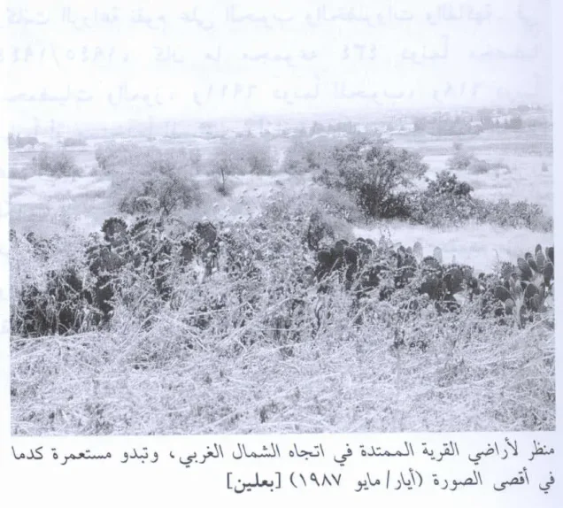
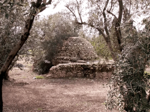
According to the field description published by Walid Khalidi in All That Remains, only the rubble of a few houses remained at the village site. Wild grasses and thorny plants covered the area, together with several trees and cactus plants, and the site was enclosed by barbed wire.
Parts of the surrounding land had been planted with mango trees and grapes, while other areas were being used as pasture.
This description derives from field research published in Khalidi's book in 1992. Palestine Remembered also contains photographs of the village site and its ruins, including material associated with All That Remains, but these materials do not constitute a comprehensive independent contemporary field survey.
The approved sources used here therefore do not provide a sufficiently comprehensive and independent recent field verification of the precise condition of every part of the Bi'lin site in 2026.
Sources
- PalQuestPalQuest – Interactive Encyclopedia of the Palestine Question: Bi'lin
- PalQuestPalQuest – Operation An-Far
- Palestine RememberedPalestine Remembered – Bi'lin, Gaza District
- Palestine RememberedPalestine Remembered – Bi'lin entry from All That Remains
- Institute for Palestine StudiesInstitute for Palestine Studies – All That Remains, Walid Khalidi
Photo gallery


Photos from the village's people
Photos sent in by visitors and published after review.
Add a photo of this village
Log in to add photos of this village.
Other villages from Gaza
More from the archive


 Download Our Palestine App
The whole archive in the palm of your hand: depopulated villages, the Nakba, the massacres and Al-Aqsa — free, with no ads to erase the story.
Download Our Palestine App
The whole archive in the palm of your hand: depopulated villages, the Nakba, the massacres and Al-Aqsa — free, with no ads to erase the story.



Comments
No comments yet — be the first to write one.
Add your comment
Name and email are optional. Comments appear after review.