
The depopulated village of Qastina / District of Gaza
Qastina
About the depopulated village of Qastina
- District
- Gaza
- Date Qastina was occupied
- 09 July 1948
- Population in 1948
- 1,032
- Brigade that carried it out
- Givati Brigade
- Who defended the village
- Egyptian Army, and local Palestinian militia.
- Distance from the governorate centre
- 38 km northeast of Gaza
- Elevation above sea level
- 50 m
- Cause of displacement
- Direct military assault by Israeli occupation forces (the Givati Brigade), whose orders called for civilians to be expelled; Khalidi considers it probable that the villagers were driven south towards Gaza, while a later Israeli army report claims they fled as the operation began
- Extent of destruction
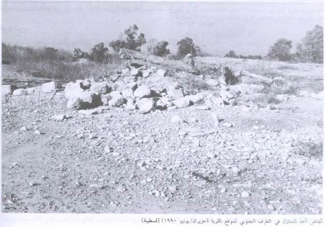
- The village has been completely destroyed, and only house rubble left behind.
- Ethnic cleansing
- Qastina inhabitants were completely ethnically cleansed.
- Settlements built on the land of Qastina before 1948
- Kefar Warburg, established in 1939 on land traditionally belonging to the village, 3 km southwest of the village site
- Settlements built on the built-up area of Qastina after 1948
- Arugot and Kefar Achim (1949), Avigdor (1950) and Qiryat Mal'akhi (1951), on village lands
Hover a dot to read the village name, or click to open its card.
Borders of the depopulated village of Qastina
Qastina – A Depopulated Palestinian Village in the Gaza Subdistrict
Qastina was a Palestinian village in the Gaza Subdistrict, located approximately 38 km northeast of Gaza city and about 50 metres above sea level. Its Palestinian inhabitants were displaced during the Nakba and the occupation of Palestine in 1948. The village was subsequently destroyed, and Israeli settlements were established on its lands.
- Subdistrict
- Gaza
- Distance from district center
- 38 km northeast of Gaza
- Average Elevation
- 50 m above sea level
- Population in 1931
- 593
- Number of Houses in 1931
- 147
- Population in 1944/1945
- 890
- Estimated Population in 1948
- About 1,032 – a later demographic estimate, not an official census
- Total Land Area in 1945
- 12,019 dunams – of which 8,438 dunams Arab-owned, 3,135 dunams Jewish-owned and 446 dunams public land
- Attack and Depopulation
- The Givati Brigade occupied the village around 9 July 1948, shortly after the end of the first truce, as it advanced southwards into Egyptian-controlled territory, within an area of at least sixteen villages that it seized between the two truces and all of whose inhabitants were displaced. Khalidi considers it probable that the people of Qastina were driven south towards Gaza; the operational orders of brigade commander Shim'on Avidan called for civilians to be expelled, while a later Israeli army report claims that the inhabitants of the area fled almost as soon as the operation began.
- Final Israeli Control
- Around 9 July 1948, shortly after the end of the first truce
- Military Unit
- Givati Brigade
- Cause of Depopulation
- Direct military assault by Israeli occupation forces (the Givati Brigade), whose orders called for civilians to be expelled; Khalidi considers it probable that the villagers were driven south towards Gaza, while a later Israeli army report claims they fled as the operation began
- Settlements Documented on Village Lands
- Kefar Warburg, established in 1939 on land traditionally belonging to the village, 3 km southwest of the village site; Arugot and Kefar Achim (1949), Avigdor (1950) and Qiryat Mal'akhi (1951), on village lands
Location of Qastina
- Subdistrict: Gaza.
- Distance from Gaza: approximately 38 km northeast.
- Elevation: approximately 50 metres above sea level.
- The village was approximately 3 km from al-Masmiyya al-Kabira.
Qastina stood on a slightly elevated and generally flat area of the Palestinian coastal plain. It was located on the highway connecting the city of al-Majdal, to the southwest, with the Jerusalem–Jaffa highway.
The British military camp known as Beer Tuvia was approximately 3 km southwest of the village.
Qastina in Historical Sources
In 1596, Qastina was a village in the nahiya of Gaza within the liwa' of Gaza, with an estimated population of 385. Its inhabitants paid taxes on wheat, barley, sesame, fruit, goats, beehives, and vineyards.
The Syrian Sufi traveller Mustafa al-Bakri al-Siddiqi, who travelled through the area in the mid-eighteenth century, also recorded passing through Qastina on his way to al-Masmiyya.
By the late nineteenth century, Qastina extended over flat land along a northwest–southeast axis. Its buildings were constructed mainly of adobe brick, and the village contained a well and gardens.
Education in Qastina
Qastina had a mosque and an elementary school founded in 1936. The school was shared with the neighbouring village of Tall al-Turmus, located to the southeast. By the mid-1940s, 161 pupils were enrolled.
Population of Qastina
Qastina's Palestinian inhabitants were Muslims and obtained water for domestic use from village wells.
According to the official Government of Palestine census of 1922, Qastina had 406 inhabitants, all Muslims. In the 1931 census, its population had increased to 593, consisting of 292 males and 301 females living in 147 houses. The 1945 statistics recorded 890 inhabitants, all Arab Muslims.
Economic Life in Qastina
Agriculture formed the backbone of Qastina's economy, with cereals and citrus among its most important crops. Villagers also raised livestock and poultry, while some worked at the nearby British military camp.
In 1944/45, 235 dunums of Arab-owned land were devoted to citrus and bananas, 770 dunums were irrigated or used for plantations, and 7,317 dunums were planted with cereals. A further 3,069 dunums of Jewish-owned land were planted with cereals.
According to the Government of Palestine's 1945 Village Statistics, Qastina had a total land area of 12,019 dunums.
Land Ownership in Qastina in 1945
Land ownership in Qastina, 1944/45
- Arab8,438 dunums70%
- Jewish3,135 dunums26%
- Public446 dunums4%
Land Use in Qastina in 1945
Land use in Qastina, 1944/45
- Arab (dunums)
- Jewish (dunums)
- Public (dunums)
- Citrus and bananas235 dunums
- Plantations and irrigable land770 dunums
- Cereals10,386 dunums
- Built-up land103 dunums
- Cultivable land11,391 dunums
- Non-cultivable land525 dunums
Population Statistics for Qastina
Population of Qastina
- 1596385Historical estimate based on Ottoman records
- 1922406Official Government of Palestine census
- 1931593Official Government of Palestine census
- 1945890Government of Palestine statistics
- 19481,032Estimate reported by Palestine Remembered
- Estimated refugees in 19986,340Estimate reported by Palestine Remembered
Number of Houses in Qastina
Number of houses in Qastina
- 1931147Official census figure
- 1948255Estimate reported by Palestine Remembered
Occupation and Depopulation of Qastina during the Nakba
Israeli forces occupied Qastina around 9 July 1948, shortly after the end of the first truce, as the Giv'ati Brigade advanced southward toward areas held by Egyptian forces.
During the Ten Days between the two truces, from 8 to 18 July 1948, the Giv'ati Brigade seized an area containing at least sixteen Palestinian villages, whose inhabitants were displaced.
Walid Khalidi, as reproduced by PalQuest, considers it probable that the residents of Qastina, like those of neighbouring al-Masmiyya, were driven south toward Gaza rather than east toward the Hebron area. Operational orders issued by Giv'ati Brigade commander Shim'on Avidan called for civilians to be expelled.
PalQuest also reports, through the sources cited by Khalidi, a later Israeli military account claiming that inhabitants of the area fled shortly after the operation began. Because the accounts differ, the exact circumstances under which every resident left cannot be established uniformly. What is clear is that Qastina was completely depopulated of its Palestinian inhabitants in the course of the military offensive.
PalQuest further states that Qastina had previously been named in Plan Dalet as one of the villages designated for occupation by the Giv'ati Brigade.
Occupation and Depopulation Chronology
- 1939
Settlement on village lands
Jewish immigrants from Germany and central and eastern Europe established Kefar Warburg on what was traditionally village land, 3 km southwest of the village site.
- 10 March 1948 (finalisation of the plan)
Inclusion of the village in Plan Dalet
Plan Dalet mentioned Qastina as one of the villages to be occupied by the Givati Brigade; the Haganah finalised the plan on 10 March 1948 and put it into execution on 1 April 1948, according to PalQuest's chronology.
- Around 9 July 1948
Final occupation
The Givati Brigade occupied the village shortly after the end of the first truce, as it advanced southwards into Egyptian-controlled territory; during the Ten Days between the two truces (8–18 July) the brigade seized an area comprising at least sixteen villages, all of whose inhabitants were displaced.
- July 1948
Depopulation of the village
Khalidi considers it probable that the residents of Qastina, like those of nearby al-Masmiyya, were driven south towards Gaza rather than east to the Hebron area. The operational orders issued by brigade commander Shim'on Avidan called for civilians to be expelled, while a later Israeli army report claims that the inhabitants of the area fled almost as soon as the operation began.
- 1948
Destruction of the village
PalQuest states that the settlements of Arugot and Kefar Achim were established in 1949, 'one year after the destruction of Qastina'; the available sources do not give the exact date of the destruction.
- 1949
Settlement on village lands
The Zionists established the settlements of Arugot and Kefar Achim, which PalQuest lists among the Israeli settlements on village lands.
- 1950
Settlement on village lands
The settlement of Avigdor was founded on village lands.
- 1951
Settlement on village lands
The settlement of Qiryat Mal'akhi was founded on village lands; it was named after the author of the Old Testament Book of Malachi and after the Los Angeles community for its support of Israel (mal'akhim is Hebrew for angels).
Military Operation and Attacking Unit
The unit documented as having occupied Qastina was the Giv'ati Brigade, and the village was occupied around 9 July 1948.
Palestine Remembered identifies the military operation as possibly Operation An-Far. Operation An-Far began on 8 July and continued until 15 July 1948 and was carried out by the First Battalion of the Giv'ati Brigade against Egyptian forces.
However, PalQuest's dedicated entry for Operation An-Far does not explicitly include Qastina among the villages it names as affected by the operation, although its Qastina entry places the village's occupation within the same military offensive and time period. The association with Operation An-Far is therefore presented as probable rather than conclusively established across all consulted sources.
Fate of Qastina's Inhabitants and Buildings
Qastina's Palestinian inhabitants were displaced during the Nakba, with the available accounts indicating that many probably moved south toward the Gaza area. Following the occupation, the village was destroyed. Walid Khalidi's documentation records only scattered house rubble remaining at the site.
Israeli Settlements on Qastina's Lands
In 1939, before the Nakba, Kefar Warburg was established on land traditionally belonging to Qastina, approximately 3 km southwest of the village site. PalQuest states that it was established by Jewish refugees from Germany and central and eastern Europe.
Following Qastina's destruction, Arugot and Kefar Achim were established in 1949. Avigdor was founded in 1950, and Qiryat Mal'akhi in 1951, on village lands.
According to Walid Khalidi and PalQuest, Qiryat Mal'akhi was named after Malachi, the figure associated with the Old Testament Book of Malachi, as well as in honour of the Los Angeles community for its support of Israel, drawing on the Hebrew word mal'akhim, meaning “angels.”
Qastina Today
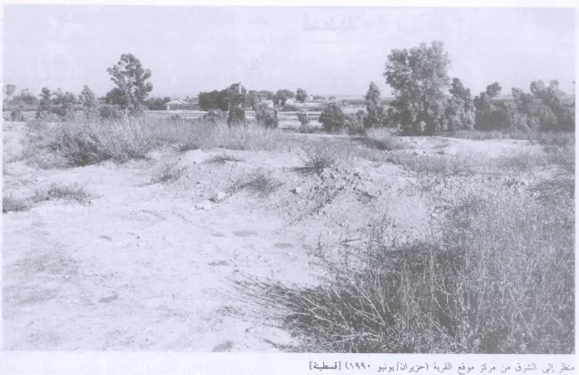
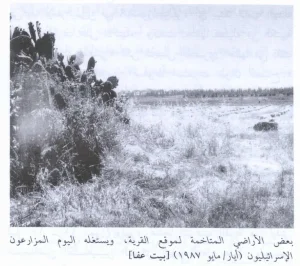
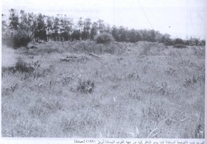
The reviewed sources do not provide a recent field survey of Qastina's site as of 2026. The documented description reproduced by PalQuest from Walid Khalidi records house rubble scattered across the site, which was overgrown with wild vegetation and tall grasses reaching approximately two metres in height.
Mallow, or khubbayza, grew densely across the site. The research account states that when a photographer later returned, the mallow had been burned. The source does not identify who caused the burning or why.
The same documented description records a dirt road passing through the centre of the former village site and eucalyptus trees growing there. This should be understood as the condition recorded at the time of the field documentation rather than as a verified on-site description for 2026.
Sources
- PalQuestPalQuest – Qastina
- PalQuestPalQuest – Operation An-Far
- Palestine RememberedPalestine Remembered – Qastina, Gaza District
- maktabatsabil.comVillage Statistics 1945 – Population and Land Ownership, Gaza Subdistrict
- maktabatsabil.comVillage Statistics 1945 – Cultivable Land and Land Use
- maktabatsabil.comVillage Statistics 1945 – Built-up and Non-Cultivable Land
- Palestine RememberedGovernment of Palestine – Census of Palestine, 1931
- Government of Palestine, J. B. Barron, Report and General Abstracts of the Census of 1922, 1923.
- Walid Khalidi, All That Remains: The Palestinian Villages Occupied and Depopulated by Israel in 1948, Institute for Palestine Studies, 1992.
Photo gallery


Photos from the village's people
Photos sent in by visitors and published after review.
Add a photo of this village
Log in to add photos of this village.
Other villages from Gaza
More from the archive


 Download Our Palestine App
The whole archive in the palm of your hand: depopulated villages, the Nakba, the massacres and Al-Aqsa — free, with no ads to erase the story.
Download Our Palestine App
The whole archive in the palm of your hand: depopulated villages, the Nakba, the massacres and Al-Aqsa — free, with no ads to erase the story.



Comments
No comments yet — be the first to write one.
Add your comment
Name and email are optional. Comments appear after review.