
The depopulated village of Al-Mazar (Jenin) / District of Haifa
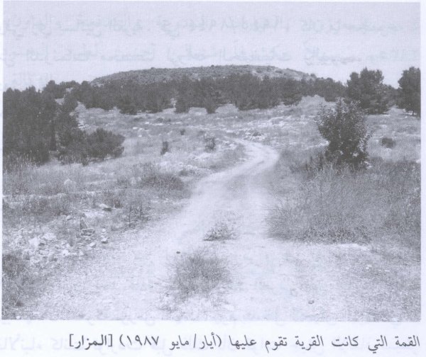
Al-Mazar (Jenin)
About the depopulated village of Al-Mazar (Jenin)
- District
- Haifa
- Date Al-Mazar (Jenin) was occupied
- 15 July 1948
- Population in 1948
- 313
- Military operation
- Operation Shoter (“Policeman”)
- Brigade that carried it out
- Golani Brigade
- Distance from the governorate centre
- 18.5 (km) South East of Haifa
- Elevation above sea level
- 65 m
- Cause of displacement
- Influence of fall of, or exoduce from, neighboring town
- Extent of destruction
- The village has been completely destroyed, and only house rubble left behind.
- Ethnic cleansing
- al-Mazar inhabitants were completely ethnically cleansed.
- Settlements built on the built-up area of Al-Mazar (Jenin) after 1948
- Prazon, Gan Ner, Meitav
- Refugees' migration routes
- The villagers were terrorized into fleeing eastward to Jinin (West Bank).
Hover a dot to read the village name, or click to open its card.
Borders of the depopulated village of Al-Mazar (Jenin)
Al-Mazar – Depopulated Palestinian Village of the Haifa District
Al-Mazar, also referred to in Palestinian local documentation as Mazar Ijzim or Mazar al-Sahil, was a depopulated Palestinian village in the Haifa District. It stood on the lower western slopes of Mount Carmel, overlooking the narrow coastal plain and the Mediterranean Sea, approximately 15.5 kilometers south of Haifa, at an average elevation of about 65 meters above sea level.
Al-Mazar was depopulated during the Nakba and the 1948 occupation of Palestine. Walid Khalidi considers it most likely that Israeli forces occupied the village in mid-July 1948 during a limited joint ground-and-naval offensive against Palestinian villages south of Haifa during the Ten Days between the two truces. The village-specific source does not establish an exact day or identify a particular land brigade as the force that entered al-Mazar.
Distinguishing al-Mazar of Haifa from al-Mazar of Jenin
This village should not be confused with another depopulated Palestinian village named al-Mazar in the Jenin District.
The al-Mazar discussed here stood on the southern Carmel coastal sector south of Haifa, whereas al-Mazar of Jenin stood on Mount al-Mazar northeast of Jenin. The two villages had entirely separate populations, lands, and occupation histories.
Location and Geography
Al-Mazar stood on the lower western slopes of Mount Carmel, overlooking the narrow coastal plain and the Mediterranean Sea.
PalQuest places it approximately 15.5 kilometers from Haifa at an average elevation of about 65 meters above sea level. Supporting Palestinian local documentation gives approximately 19 kilometers and 70 meters, probably reflecting a different method or point of measurement.
Approximately one-third of the village lands lay on Mount Carmel, while the remaining two-thirds extended across the coastal plain.
The main coastal highway passed along the village's western edge, and the Crusader fortress at 'Atlit stood approximately 2.5 kilometers to the north.
Supporting Palestinian local documentation places 'Ayn Hawd to the north, Khirbat al-Mansura and Umm al-Daraj to the east, 'Atlit to the west, Jaba' to the south, Ijzim to the southeast, Kafr Lam and al-Sarafand to the southwest, and Daliyat al-Karmil to the northeast.
Name
The Arabic word mazar means a shrine or a place that people visit.
Walid Khalidi suggests that the village was probably named in memory of the many people said to have been killed and buried in the area during fighting against the Crusaders.
Palestinian local documentation also uses the names Mazar Ijzim and Mazar al-Sahil, reflecting the village's close social and territorial relationship with neighboring Ijzim, although al-Mazar was listed independently in the 1945 statistics.
Built Environment
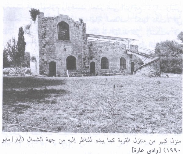
The village had an approximately square plan, and its houses were built of stone.
The official 1944/45 statistics classified 39 dunams as built-up land.
Al-Mazar had a mosque that remained standing until 1983. Supporting Palestinian community documentation also records a shrine and three cemeteries.
Population and Houses
The inhabitants of al-Mazar were Muslims.
| Year | Population | Note |
|---|---|---|
| 1922 | 134 | Official Mandate census; all inhabitants were Muslims |
| 1931 | No separate village figure available | Al-Mazar was enumerated together with Ijzim, Khirbat Qumbaza, Khirbat al-Manara, al-Washahiyya, and Shaykh al-Burayk; the combined unit totaled 2,160 inhabitants |
| 1945 | 210 | Independent official statistics; all inhabitants were Palestinian Arab Muslims |
| 1948 | About 244 | Later Palestine Remembered estimate, not an official British census |
| 1998 | About 1,496 refugees and descendants | Later demographic estimate |
The figure of 442 houses in the 1931 census belongs to the combined statistical unit that included al-Mazar, Ijzim, and several nearby khirbas and settlements. It must not be attributed to al-Mazar alone.
The figure of 442 houses for 1948 displayed in some online tables is likewise not used here. It appears to reproduce the combined 1931 figure and is not a reliable independent estimate of al-Mazar's houses.
Mosque and Education
Al-Mazar had a mosque, whose structure survived until 1983 according to Khalidi's field description.
The principal village entry does not document a formal Mandate-era school. Supporting Palestinian local documentation states that the British authorities did not establish a school in the village and that elementary religious instruction was provided through a kuttab in the mosque.
The kuttab is therefore recorded as local educational practice rather than as a government school.
Water Resources
The inhabitants obtained domestic water from a spring situated southeast of the village.
Khalidi does not provide a securely documented name for this spring, so no unverified local name is added.
Economic Life and Agriculture
Agriculture and animal husbandry formed the principal foundations of the village economy.
Cereals were the main crop, alongside vegetables and fruit trees. Smaller areas were also planted with citrus, bananas, and olives.
Supporting Palestinian local documentation states that production largely met local needs and that surpluses were sold to neighboring villages and markets.
Land Ownership, 1944/45
The total land area of al-Mazar was 7,976 dunams. Under the official Government of Palestine classification, ownership was distributed as follows:
- Arab4,432 dunums56%
- Jewish856 dunums11%
- Public2,688 dunums34%
Palestine Remembered presents the same figures using its simplified terminology: 4,432 dunams “Palestinian,” 856 dunams “Transferred to Zionists,” and 2,688 dunams “Communal/Public.” The wording “Transferred to Zionists” should be preserved when reproducing that source's terminology.
Land Use, 1944/45
- Arab
- Jewish
- Public
- Citrus and bananas5 dunums
- Plantations and irrigable land586 dunums
- Cereals4,493 dunums
- Total cultivable/cultivated land5,084 dunums
- Non-cultivable land2,853 dunums
- Built-up land39 dunums
- Total non-cultivable and built-up2,892 dunums
The official table balances exactly: 5,084 dunams of cultivable or cultivated land plus 2,892 dunams of built-up and non-cultivable land equal the total village area of 7,976 dunams.
Approximately 100 dunams of the Arab agricultural land were planted with olives. This is a crop-specific subset and should not be added again to the overall land-use total.
Archaeological Remains
The al-Mazar site contained pottery fragments, rock-cut tombs, and dressed stones.
These remains indicate long-term human activity in the Carmel coastal region, although the principal sources reviewed do not permit all archaeological remains to be assigned to one specific historical period.
Al-Mazar after the Fall of Haifa
Following the fall of Haifa in late April 1948, al-Mazar remained outside Israeli control for several more weeks, like al-Tira, 'Ayn Hawd, and a number of other Palestinian villages south of the city.
Walid Khalidi estimates that al-Mazar avoided occupation for approximately six weeks after Haifa fell.
The Joint Ground-and-Naval Offensive of July 1948
During the Ten Days between the two truces, from 8 to 18 July 1948, Israeli forces launched a series of attacks against Palestinian villages south of Haifa.
Around 15–16 July, a limited military thrust used naval fire to support land forces in this coastal sector, marking the first such ground-and-naval cooperation in attacks on these villages.
The offensive resulted in the capture of al-Tira, Kafr Lam, and al-Sarafand, and probably 'Ayn Hawd. Khalidi considers it likely that al-Mazar was occupied during this same period and context.
Occupation and Depopulation
Walid Khalidi does not provide a definitive day for al-Mazar's occupation. He places its capture in mid-July 1948 during the joint ground-and-naval offensive south of Haifa.
Palestine Remembered and supporting Palestinian local documentation index 15 July as the occupation date. Khalidi's narrative, however, remains more cautious and does not establish that day conclusively.
He also leaves open the possibility that al-Mazar may have resisted attacks until later in July, because the nearby “Little Triangle” of Ijzim, Jaba', and 'Ayn Ghazal continued to hold out south of the village.
The safest formulation is therefore that al-Mazar was most likely occupied in mid-July 1948, probably around 15–16 July, while the exact final date remains uncertain.
Khalidi suggests that the inhabitants may have been expelled in circumstances similar to those at neighboring al-Tira, but he does not establish this as a village-specific certainty. The article therefore records the depopulation as a consequence of the military assault without claiming that every villager was expelled in exactly the same manner.
Was al-Mazar Occupied in Operation Shoter?
Palestine Remembered currently classifies al-Mazar under Operation Shoter, or “Police,” and associates it with a composite force drawn from the Golani, Carmeli, and Alexandroni brigades.
The chronology in the principal sources does not securely support that attribution.
Operation Shoter began on 24 July 1948 during the second truce and was directed primarily against the “Little Triangle” villages of Ijzim, Jaba', and 'Ayn Ghazal. A special force drawn from Golani, Carmeli, and Alexandroni units participated in that operation.
Al-Mazar, by contrast, is most likely placed by Khalidi in the earlier mid-July ground-and-naval offensive associated with the capture of al-Tira, Kafr Lam, and al-Sarafand.
This article therefore does not identify Operation Shoter as the confirmed operation that captured al-Mazar and does not transfer the Golani–Carmeli–Alexandroni composite force to the village without direct village-specific evidence.
Military Unit
The village-specific evidence establishes that al-Mazar was taken in the context of a joint Israeli ground-and-naval offensive in mid-July 1948.
Khalidi's al-Mazar entry does not identify a specific land brigade as the formation that entered the village.
The Golani, Carmeli, and Alexandroni brigades are directly documented as participating in the later Operation Shoter against Ijzim, Jaba', and 'Ayn Ghazal. They should not therefore be listed conclusively as the village-level attacking units at al-Mazar without separate evidence.
Occupation Chronology
- 22 April 1948
Fall of Haifa
Al-Mazar remained outside Israeli control for several weeks after the district capital fell.
- Late April – early July 1948
Continued survival outside Israeli control
Khalidi estimates that the village avoided occupation for roughly six weeks after the fall of Haifa.
- Around 15–16 July 1948
Joint ground-and-naval offensive
Israeli forces used naval fire to support ground attacks that captured al-Tira, Kafr Lam, and al-Sarafand and probably 'Ayn Hawd; al-Mazar most likely fell in the same context.
- 15 July 1948
Indexed occupation date
Used by Palestine Remembered and Palestinian local documentation, but not conclusively established by Khalidi.
- Until later July 1948
Possible continued resistance
Khalidi leaves open the possibility that al-Mazar may have held out longer because the nearby Little Triangle remained unconquered.
- 24–26 July 1948
Operation Shoter
Directed primarily against Ijzim, Jaba', and 'Ayn Ghazal; available village-specific evidence does not securely place al-Mazar within this operation.
- Exact date not documented
Destruction of the village
The village was later destroyed; the mosque itself remained standing until 1983.
Israeli Settlement and Village Lands
En Karmel was established in 1947 approximately one kilometer west of the al-Mazar village site.
Khalidi does not state that the settlement was originally built entirely on al-Mazar's lands. Rather, he notes that some of En Karmel's buildings now stand on village land.
This distinction is retained between the settlement's original location west of the village and its later physical extension into al-Mazar's cadastral lands.
Al-Mazar Today
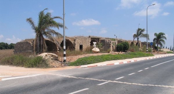
According to the field description published in Walid Khalidi's All That Remains, rubble from stone houses was scattered throughout the village site.
Wild grass, thorns, cactuses, and fig, pomegranate, and mulberry trees covered the area.
Segments of standing stone walls were still visible, along with the remains of the village mosque, which had remained standing until 1983.
This description should not be treated as a comprehensive field verification of conditions in 2026. Fieldwork for All That Remains was conducted between 1987 and 1990. Later Palestinian community documentation of the site exists, but it does not replace a comprehensive contemporary field survey.
Sources
- PalQuest – Interactive Encyclopedia of the Palestine Question: al-Mazar, Haifa
- Palestine Remembered – al-Mazar, Haifa District
- Palestinian Villages Encyclopedia – al-Mazar / Mazar Ijzim / Mazar al-Sahil; supporting Palestinian local documentation
- PalQuest – Ijzim; for the combined 1931 enumeration and the Little Triangle context
- PalQuest – al-Tira, Haifa District; for the mid-July ground-and-naval offensive
- PalQuest – Kafr Lam; for the limited 15–16 July offensive
- PalQuest – al-Sarafand; for naval support during the coastal offensive
- PalQuest – Jaba'; for Operation Shoter and its distinction from al-Mazar's likely occupation context
- Institute for Palestine Studies – Walid Khalidi, All That Remains
- PalQuest – All That Remains: Methodology
Photos from the village's people
Photos sent in by visitors and published after review.
Add a photo of this village
Log in to add photos of this village.
Other villages from Haifa

More from the archive

 Download Our Palestine App
The whole archive in the palm of your hand: depopulated villages, the Nakba, the massacres and Al-Aqsa — free, with no ads to erase the story.
Download Our Palestine App
The whole archive in the palm of your hand: depopulated villages, the Nakba, the massacres and Al-Aqsa — free, with no ads to erase the story.



Comments
No comments yet — be the first to write one.
Add your comment
Name and email are optional. Comments appear after review.