
The depopulated village of Wa'arat al-Sarris / District of Haifa

Wa'arat al-Sarris
About the depopulated village of Wa'arat al-Sarris
- District
- Haifa
- Date Wa'arat al-Sarris was occupied
- 16 April 1948
- Population in 1948
- 220
- Who defended the village
- Arab Liberation Army
- Distance from the governorate centre
- 11 (km) East of Haifa
- Elevation above sea level
- 25 m
- Cause of displacement
- Military assault by Zionist troops
- Extent of destruction
- The village has been completely destroyed, and only house rubble left behind.
- Ethnic cleansing
- Wa'arat al-Sarris inhabitants were completely ethnically cleansed.
Hover a dot to read the village name, or click to open its card.
Borders of the depopulated village of Wa'arat al-Sarris
Wa'arat al-Sarris – Depopulated Palestinian Village of Haifa
Wa'arat al-Sarris was a Palestinian village in the Haifa Subdistrict, approximately 11 kilometers east of Haifa and about 25 meters above sea level.
The village stood on the summit of a small hill facing Mount Carmel to the west and southwest and lay close to a main road leading toward Haifa. Hawsha and Khirbat al-Kasayir were nearby to the southwest, Shafa 'Amr to the southeast, and 'Ibillin to the northeast.
Wa'arat al-Sarris had a population of 190 in the 1944/45 statistics. The precise date and mechanism of its final depopulation are not firmly established in Walid Khalidi's account. He considers it possible that the village was occupied or evacuated as a result of the fighting at Hawsha and Khirbat al-Kasayir on 16 April 1948; alternatively, any residents who remained may have left after the fall of Haifa on 22 April and the subsequent military advance through the surrounding area.
Basic Information
| Field | Information |
|---|---|
| Name | Wa'arat al-Sarris |
| Arabic name | وَعْرَة السَرِّيس |
| Subdistrict | Haifa |
| Location | East of Haifa |
| Distance from Haifa | Approximately 11 km |
| Average elevation | Approximately 25 m above sea level |
| Palestine Grid | 161/245 |
| Population in 1931 | No independent figure; Wa'arat al-Sarris was included in a combined statistical unit with a total population of 1,197 |
| Population in 1944/45 | 190 |
| 1948 population estimate | 220 – later estimate, not an official census |
| Independent land area | No separate verified land table was located for Wa'arat al-Sarris alone |
| Probable depopulation period | Between 16 and 22 April 1948; Khalidi does not establish a definitive final date |
| Military context | Battle of Ramat Yohanan and the attack on Hawsha and Khirbat al-Kasayir, followed by the fall of Haifa and the military advance into its hinterland |
| Military unit | The Carmeli Brigade is directly documented in the attack on Hawsha and Khirbat al-Kasayir; its direct entry into Wa'arat al-Sarris itself is not independently established |
| Cause of depopulation | Military operations and pressure resulting from the fall of neighboring villages and Haifa; the precise village-level sequence remains uncertain |
| Israeli settlement | Qiryat Ata was founded before 1948, in 1925, and later expanded so that some of its buildings occupied the village site |
Name
The principal Palestinian sources consulted do not provide a securely documented etymology for the full name Wa'arat al-Sarris.
The Arabic word wa'ra can generally refer to rough or difficult terrain, but this general meaning should not automatically be treated as the historical explanation of the village name. No independently documented derivation of the second element, al-Sarris, was located.
Location and Boundaries
Wa'arat al-Sarris stood on a small hilltop facing Mount Carmel to the west and southwest and near a road leading toward Haifa.
Palestinian local documentation places Hawsha and Khirbat al-Kasayir to the southwest, Shafa 'Amr to the southeast, and 'Ibillin to the northeast.
Its location placed the village within the rural zone between Haifa and Shafa 'Amr and near the battlefield that became known in April 1948 as the Battle of Ramat Yohanan.
Population
The population figures require particular care because the 1931 census grouped Wa'arat al-Sarris with a number of other small localities.
- 19311,197Combined statistical total, not the population of Wa'arat al-Sarris alone
- 1944/45190Independent Mandate-period figure for Wa'arat al-Sarris; the inhabitants were recorded as Muslims
- 1948220Later Palestine Remembered estimate, not an official census
- 19981,354Later estimate of refugees and descendants, not an official census
The 1931 total of 1,197 included Wa'arat al-Sarris together with Khirbat Sa'sa', al-Hilf, 'Arab al-Madabigh, 'Arab Murairiya, 'Arab al-Zubaidat, 'Arab al-Majadib, Ard al-Tuwal, Mathanat Kurdana, and Ras 'Ali. The village's own population cannot be extracted from that combined total without additional documentation.
Number of Houses
The 1931 census recorded 234 houses for the same combined statistical unit containing Wa'arat al-Sarris and nine other localities.
The figure of 234 should therefore not be presented as the number of houses in Wa'arat al-Sarris itself. No reliable independent 1948 house count was located.
Land and Land Ownership
No independent 1945 land table was located that would allow Wa'arat al-Sarris to be divided reliably into Palestinian, Transferred to Zionists, and Public ownership categories.
Khalidi states that the village's original landholdings were later combined with lands belonging to the Palestinian town of Shafa 'Amr.
This article therefore does not create a speculative land-ownership or land-use table and does not transfer land figures from Shafa 'Amr or neighboring localities to Wa'arat al-Sarris.
Economy
No separate land-use statistics were located from which precise areas of cereals, orchards, or other crops can be calculated for Wa'arat al-Sarris.
The village was a small rural community within an agricultural and pastoral zone between Haifa and Shafa 'Amr. Khalidi's later description records grazing on surrounding lands, but this later use should not automatically be projected backward as a complete description of the village's pre-1948 economy.
Education
Palestinian village documentation states that Wa'arat al-Sarris had no school during the British Mandate.
No independent school register, founding year, or pupil and teacher totals were located in the principal sources consulted, so no unsupported educational figures are supplied.
Religious Buildings
No clearly documented mosque, shrine, or church specific to Wa'arat al-Sarris was identified in the principal sources used here.
The fact that the 1945 population was Muslim is not sufficient by itself to establish the existence of a particular religious building.
Water and Archaeology
No independently documented wells, springs, or named cisterns specific to Wa'arat al-Sarris were located in the principal Palestinian sources used for this article.
Likewise, no sufficiently detailed Palestinian archaeological record was located that would justify assigning particular remains at the site to a specific historical period.
The 3 February 1948 Engagement
Walid Khalidi, drawing on the Palestinian newspaper Filastin, records an armed engagement near Wa'arat al-Sarris shortly after midnight on 3 February 1948.
The fighting lasted for more than an hour, and the newspaper report did not record casualties. This is the earliest military incident documented near Wa'arat al-Sarris in 1948, but it did not constitute the village's final occupation or depopulation.
The Battle of Ramat Yohanan
In April 1948 the area west of Shafa 'Amr became a battlefield between Haganah forces and a Druze battalion of the Arab Liberation Army.
The Arab Liberation Army force operated from Hawsha and Khirbat al-Kasayir, both close to Wa'arat al-Sarris, during the fighting around Ramat Yohanan.
During the night of 15–16 April, Carmeli Brigade forces captured Hawsha and Khirbat al-Kasayir after heavy fighting, and subsequent counterattacks failed to retake them.
Was Wa'arat al-Sarris Occupied on 16 April?
Palestine Remembered and Palestinian village documentation give 16 April 1948 as the occupation date of Wa'arat al-Sarris.
Khalidi's village-specific account is more cautious. He states that because Wa'arat al-Sarris lay close to Hawsha and Khirbat al-Kasayir, it may have been occupied or evacuated as a consequence of the 16 April attack on those two villages.
Accordingly, 16 April should be retained as a widely cited and plausible date rather than presented as a conclusively documented day on which troops definitely entered Wa'arat al-Sarris.
Possible Continued Residence until the Fall of Haifa
Khalidi offers a second possibility. If villagers remained after the 16 April fighting, they may have left after the fall of Haifa on 22 April and the subsequent Haganah advance into the surrounding countryside.
The most defensible documented depopulation window is therefore between 16 and 22 April 1948, while the exact date on which the final residents left remains uncertain.
Military Operation
Palestine Remembered assigns Operation Bi'ur Hametz to Wa'arat al-Sarris.
This presents a chronological problem. PalQuest dates Operation Bi'ur Hametz from 22 to 24 April 1948, after the 16 April occupation date used by Palestine Remembered itself. The operation was associated primarily with the capture and consolidation of Haifa and its immediate hinterland.
Operation Bi'ur Hametz is therefore not used here as the operation responsible for an alleged 16 April capture of Wa'arat al-Sarris.
The closer military context for 16 April is the Battle of Ramat Yohanan and the Carmeli Brigade assault on Hawsha and Khirbat al-Kasayir. Direct Carmeli occupation of Wa'arat al-Sarris itself, however, is not independently established in Khalidi's village account.
Military Unit
The Carmeli Brigade is independently documented as the formation that captured nearby Hawsha and Khirbat al-Kasayir on 15–16 April.
Since Khalidi associates the possible depopulation of Wa'arat al-Sarris with that fighting, Carmeli may be identified as the most plausible military context.
No village-specific source establishes a particular Carmeli battalion as the unit that entered Wa'arat al-Sarris. No battalion number is therefore assigned.
Cause of Depopulation
Palestine Remembered classifies the cause as direct military assault.
Khalidi's account is less definitive. The villagers may have left as a consequence of the fighting at Hawsha and Khirbat al-Kasayir on 16 April, or some may have remained until the fall of Haifa on 22 April and left amid the subsequent military advance.
The most accurate formulation is therefore that Wa'arat al-Sarris was depopulated under escalating military pressure in its immediate region, while the precise mechanism and final date of departure are not independently established.
Destruction
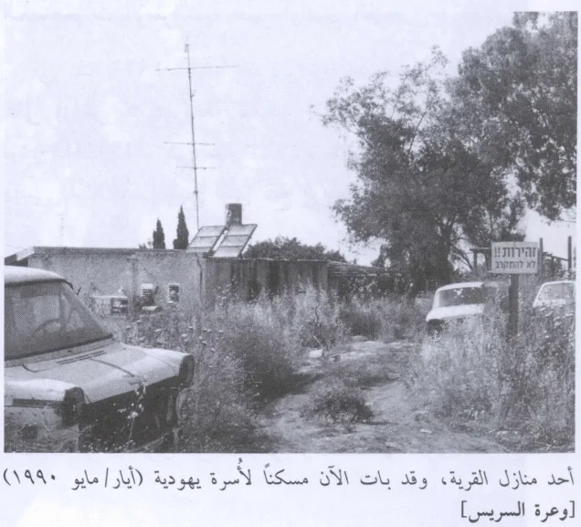
Most of the village's built environment was destroyed or transformed after depopulation, but Wa'arat al-Sarris was not completely erased.
Khalidi's field description records four partially demolished village houses and another six houses still standing and occupied at the time of his fieldwork.
This evidence contradicts simplified descriptions claiming that the village was completely destroyed with only rubble remaining.
Ethnic Cleansing in Source Classification
Palestine Remembered classifies Wa'arat al-Sarris using the term “complete ethnic cleansing.” This phrase is retained here only as an attributed source classification.
The directly documented facts are that the Palestinian population disappeared from the village during the April 1948 military events, did not return to permanent collective residence there, and that Qiryat Ata later expanded onto the village site.
Occupation and Depopulation Chronology
| Date | Event |
|---|---|
| 3 February 1948 | An armed engagement is documented near Wa'arat al-Sarris; it does not represent the final occupation of the village. |
| 11–15 April 1948 | Fighting intensifies around Ramat Yohanan; an Arab Liberation Army Druze battalion operates from Hawsha and Khirbat al-Kasayir. |
| Night of 15–16 April 1948 | Carmeli Brigade forces capture Hawsha and Khirbat al-Kasayir. |
| 16 April 1948 | Date used by several Palestinian sources for Wa'arat al-Sarris; Khalidi presents it as a plausible consequence of the neighboring battle rather than a conclusively documented village-specific occupation date. |
| 22 April 1948 | Haifa falls. Khalidi considers it possible that any residents still in Wa'arat al-Sarris left after this event and the subsequent military advance. |
| 22–24 April 1948 | Operation Bi'ur Hametz takes place in Haifa and its hinterland; it cannot explain an occupation claimed to have occurred on 16 April. |
| After depopulation | Qiryat Ata gradually expands until part of its built-up area occupies the former village site. |
Israeli Settlements on Wa'arat al-Sarris Lands
No new Israeli settlement was founded specifically on the Wa'arat al-Sarris site after the Nakba.
Qiryat Ata had already been founded in 1925, before 1948. It subsequently expanded so that some of its buildings came to occupy the former village site.
Khalidi further states that the original landholdings associated with Wa'arat al-Sarris were combined with lands belonging to the Palestinian town of Shafa 'Amr.
Qiryat Ata should therefore be classified as a pre-1948 settlement that later expanded onto the village site, rather than as a settlement newly established on Wa'arat al-Sarris lands after 1948.
Wa'arat al-Sarris Today
According to the field description used by Walid Khalidi before the publication of All That Remains in 1992, the Amidar Aleph neighborhood of Qiryat Ata occupied the former village site.
Four village houses were partially demolished, while another six houses remained standing and were occupied by Jewish families at the time of the fieldwork.
Oak, cypress, and fig trees, together with cactus plants, grew across the site.
This description derives from fieldwork conducted before the 1992 publication of All That Remains. It should therefore be treated as documented historical field evidence rather than as a comprehensive direct survey of conditions at Wa'arat al-Sarris in 2026.
Sources
- PalQuest – Interactive Encyclopedia of the Palestine Question: Wa'arat al-Sarris
- PalQuest – Operation Bi'ur Hametz and its chronology
- Palestine Remembered – Wa'arat al-Sarris, Haifa Subdistrict
- Palestine Remembered – Wa'arat al-Sarris entry from Walid Khalidi's All That Remains
- Palestinian Villages Encyclopedia – Wa'arat al-Sarris
- Falastinuna – Wa'arat al-Sarris
- Palestine Land Society – Atlas of Palestine 1917–1966
Photo gallery
Photos from the village's people
Photos sent in by visitors and published after review.
Add a photo of this village
Log in to add photos of this village.
Other villages from Haifa

More from the archive



 Download Our Palestine App
The whole archive in the palm of your hand: depopulated villages, the Nakba, the massacres and Al-Aqsa — free, with no ads to erase the story.
Download Our Palestine App
The whole archive in the palm of your hand: depopulated villages, the Nakba, the massacres and Al-Aqsa — free, with no ads to erase the story.



Comments
No comments yet — be the first to write one.
Add your comment
Name and email are optional. Comments appear after review.