
The depopulated village of Al-Sindiyana / District of Haifa

Al-Sindiyana
About the depopulated village of Al-Sindiyana
- District
- Haifa
- Date Al-Sindiyana was occupied
- 12 May 1948
- Population in 1948
- 1,450
- Military operation
- Coastal Clearing
- Brigade that carried it out
- Military assault by Zionist troops
- Who defended the village
- The village has been completely destroyed, and only house rubble left behind.
- Distance from the governorate centre
- 29 (km) South of Haifa
- Elevation above sea level
- 125 m
- Cause of displacement
- Military assault by Zionist troops
- Extent of destruction
- The village has been completely destroyed, and only house rubble left behind.
- Settlements built on the built-up area of Al-Sindiyana after 1948
- Aviel
Hover a dot to read the village name, or click to open its card.
Borders of the depopulated village of Al-Sindiyana
Al-Sindiyana – A Depopulated Palestinian Village in the Haifa Subdistrict
Al-Sindiyana was a Palestinian village in the Haifa Subdistrict, situated in Bilad al-Rawha approximately 29 km south of Haifa, at an average elevation of about 125 meters above sea level.
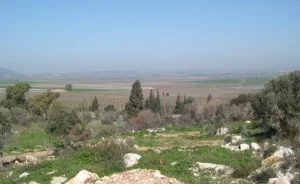
The village was built on two small hills southeast of the foothills of Mount Carmel. The larger hill was roughly circular, while the smaller hill to its east was elongated along a northwest–southeast axis.
Al-Sindiyana was depopulated during the Nakba and the occupation of Palestine in 1948. Irgun forces began an assault on several villages of Bilad al-Rawha on 12 May 1948. By 14 May, al-Sindiyana had been occupied and the remaining Palestinian inhabitants had been expelled.
- Subdistrict
- Haifa
- Region
- Bilad al-Rawha
- Distance from Haifa
- Approximately 29 km south
- Elevation
- Approximately 125 m above sea level
- Population, 1944/45
- 1,250
- Total land area
- 15,172 dunums
- Beginning of assault
- 12 May 1948
- Completion of occupation and depopulation
- 12–14 May 1948
- Military force
- Irgun / IZL / Etzel
- Military context
- Irgun assault on the villages of Bilad al-Rawha following the Mishmar ha-'Emeq fighting
- Israeli settlement on village land
- Avi'el, established in 1949
Location and Geography of Al-Sindiyana
Al-Sindiyana stood on two small hills along the southeastern edge of the Mount Carmel foothills in the Palestinian region known as Bilad al-Rawha.
The larger hill was approximately circular, while the smaller hill immediately to the east was more elongated and oriented from northwest to southeast.
Secondary roads linked the village with neighboring communities and with a highway that connected with the main coastal road.
Neighboring Villages
Palestinian maps and local documentation place al-Sindiyana among the following villages of Bilad al-Rawha:
- North and northeast: Sabbarin.
- East: Umm al-Shawf and Qannir.
- South: al-Marah.
- West: Burayka.
These are approximate geographical relationships and should not be treated as substitutes for detailed cadastral boundaries.
Name of Al-Sindiyana
The name al-Sindiyana derives from the Arabic word for an oak tree.
Local Palestinian documentation associates the name with the abundance of oak trees in the hills around the village.
Origins of the Modern Village
According to Walid Khalidi, the inhabitants who established the modern village came from the neighboring communities of Umm al-Fahm and 'Arraba and founded al-Sindiyana more than two centuries before the Nakba.
This does not mean that the surrounding area lacked earlier settlement. A number of archaeological sites and khirbas around the village preserve evidence of much older occupation.
Al-Sindiyana in the Nineteenth Century
In the late nineteenth century, al-Sindiyana stood on elevated ground with a spring below the village.
One mid-nineteenth-century estimate placed the population at approximately 300 people cultivating around 22 faddans.
The village houses were constructed of stone in a hilly agricultural environment with relatively abundant water.
Population of Al-Sindiyana
Several later Palestinian websites reproduce a figure of 276 inhabitants for 1922. The official Census of Palestine, however, records 576 inhabitants in al-Sindiyana in 1922, all Muslims.
The official 1931 census recorded 923 inhabitants. PalQuest notes that this figure includes Harrawi. The corresponding count of 217 occupied houses likewise refers to this combined statistical unit.
In the 1944/45 Village Statistics, al-Sindiyana had a population of 1,250 Arabs.
Palestine Remembered later estimated the population at 1,450 in 1948 and the number of refugees and their descendants at 8,905 in 1998. These are retrospective estimates rather than official British Mandate census figures.
- Mid-19th centuryApproximately 300Historical estimate
- 1922576Official census; all Muslims
- 1931923Official census; figure includes Harrawi
- 1944/451,250Official British Mandate statistics
- 19481,450Later estimate, not an official census
- 19988,905 refugeesLater estimate of refugees and their descendants
Number of Houses
- 1931217Occupied-house count for the statistical unit including al-Sindiyana and Harrawi
The principal sources used here do not provide a securely documented independent house count for al-Sindiyana alone in 1931 or a reliable standalone estimate for 1948.
Education in Al-Sindiyana
Al-Sindiyana had an elementary school for boys. Khalidi records approximately 200 pupils in the school in 1942/43.
The Palestinian Villages Encyclopedia, drawing on Mustafa Murad al-Dabbagh, gives 1943 as the school's founding year and states that it had around 200 pupils and five teachers in the 1947/48 school year.
The secure core fact is therefore the existence of a boys' elementary school with approximately 200 pupils by the early 1940s; the 1943 founding date derives from the later local source based on al-Dabbagh.
Land Ownership in Al-Sindiyana
The total land area of al-Sindiyana in the 1944/45 Village Statistics was 15,172 dunums.
Palestine Remembered presents the simplified ownership categories as follows:
- Palestinian9,706 dunums64%
- Transferred to Zionists864 dunums6%
- Communal/Public4,602 dunums30%
The official Village Statistics use the original categories Arab, Jewish, and Public: 9,706 dunums were classified as Arab land, 864 as Jewish land, and 4,602 as public land.
Land Use in 1944/45
- Arab
- Jewish
- Public
- Cereals8,177 dunums
- Plantations and irrigable land525 dunums
- Built-up land24 dunums
- Non-cultivable land6,446 dunums
Cultivable land totaled 8,702 dunums, approximately 57 percent of the village area: 7,838 Arab dunums and 864 Jewish dunums.
Built-up and non-cultivable land totaled 6,470 dunums, of which 1,868 were Arab and 4,602 public.
Approximately 200 dunums were planted with olive trees. This was a crop-specific figure within the 525 dunums of plantations and irrigable land and should not be added separately to the total.
Economic Life
Agriculture and livestock raising formed the principal basis of life in al-Sindiyana.
Cereals were among the main crops, together with vegetables—especially tomatoes—as well as olives and other orchard crops.
In 1944/45, 7,313 Arab dunums were devoted to cereals and 525 dunums to plantations and irrigable cultivation.
The village's numerous wells and springs supported both irrigated agriculture and animal husbandry.
Water and Springs
Al-Sindiyana had numerous wells and springs that supplied water for both domestic consumption and irrigation.
Khalidi specifically records the abundance of village wells.
Later Palestinian local documentation preserves names including 'Ayn Abu Taha northeast of the village and 'Ayn al-Mayta and 'Ayn Isma'il to the south, along with additional springs southeast of the village.
The village also overlooked Wadi al-Sindiyana, part of the broader Wadi al-Zarqa drainage system.
Archaeological Sites and Khirbas
An archaeological site known simply as al-Khirba lay about two kilometers southwest of al-Sindiyana. Khalidi records building foundations, pottery, and small tesserae or vessel fragments visible on its surface.
Farther away stood Khirbat Rusaysa, where mosaics, columns, and a rock-cut winepress suggest occupation during the Roman–Byzantine period.
Local Palestinian documentation identifies additional sites around the village, including Khirbat al-'Ajami, Khirbat al-Sitt Layla, Khirbat al-Khudayra, Khirbat Dufays, and Khirbat Tata.
The available evidence varies from site to site, so these remains should not all be assigned to a single historical period without independent archaeological study.
Local Religious Shrines
Later community documentation preserves the names of several shrines around the village, including Maqam al-'Ajami, Maqam al-Sitt Layla, Maqam al-Shaykh al-'Allam, and Maqam al-Dafayis.
Khalidi's principal village entry does not provide a detailed historical chronology for these shrines, so they are presented as landmarks preserved in local memory and community documentation.
Military Context before the Occupation
Bilad al-Rawha experienced escalating military pressure during April and May 1948, particularly following the fighting around Mishmar ha-'Emeq and Haganah attacks against Palestinian villages in the area.
On 8 May, Haganah forces attacked Kafr Qari'. Soon afterward, Irgun units assumed the offensive against a number of other villages in Bilad al-Rawha.
Irgun forces operating from the Zikhron Ya'akov, Hadera, Binyamina, and Netanya areas gathered for an assault on villages including al-Sindiyana.
Occupation and Depopulation in 1948
On 12 May 1948, Irgun forces began attacking al-Sindiyana, Sabbarin, Khubbayza, Umm al-Shawf, and other Palestinian villages in Bilad al-Rawha.
Some inhabitants had already begun leaving the area as military forces approached, but a significant number of al-Sindiyana's residents remained in the village.
Historical accounts state that the mukhtar, members of his family, and approximately 300 civilians stayed behind and raised a white flag, signaling surrender. They were nevertheless subsequently expelled.
PalQuest publishes a Haganah intelligence report dated 30 June 1948 that records al-Sindiyana under 14 May, stating that everyone had left, that the village had been “occupied by the Irgun,” and that the displaced population went toward 'Ar'ara and Ya'bad.
The most precise chronology therefore distinguishes between the beginning of the assault on 12 May and the completion of occupation and depopulation over 12–14 May 1948.
What Was the Military Operation Called?
Palestine Remembered variously associates al-Sindiyana with “Coastal Clearing” or the Mishmar ha-'Emeq operations. Khalidi's village entry and PalQuest, however, do not establish one formal operation name specifically for the Irgun assault that captured al-Sindiyana.
The battle of Mishmar ha-'Emeq preceded the village's occupation and reshaped the military balance in Bilad al-Rawha, but it is not itself a precise operation name for the 12–14 May assault on al-Sindiyana.
This article therefore uses the more cautious formulation: the Irgun assault on the villages of Bilad al-Rawha following the Mishmar ha-'Emeq fighting.
- April – early May 1948
Earlier fighting in Bilad al-Rawha
Haganah operations following the Mishmar ha-'Emeq fighting increased military pressure on Palestinian villages
- 12 May 1948
Beginning of Irgun assault
Attack on al-Sindiyana, Sabbarin, Khubbayza, Umm al-Shawf, and other villages
- 12–14 May 1948
Surrender of remaining civilians
The mukhtar, his family, and about 300 residents remained and raised a white flag
- By 14 May 1948
Completion of depopulation
Haganah intelligence report records the village as empty and occupied by the Irgun
- May 1948
Destinations of some displaced residents
'Ar'ara and Ya'bad, according to the report published by PalQuest
Israeli Settlements on the Lands of Al-Sindiyana
Avi'el: Established in 1949 on land belonging to al-Sindiyana, southwest of the former village site.
Khalidi does not identify a Zionist settlement as having been established on al-Sindiyana's lands before the Nakba.
Al-Sindiyana Today
According to Walid Khalidi's field description in All That Remains, the village site was fenced with barbed wire. Piles of stones and rubble from destroyed houses lay among thorns, cactus, and fig, olive, and palm trees.
The surrounding lands were being used for grazing.
This description derives from fieldwork conducted before the publication of All That Remains in 1992 and should not be treated as direct verification of conditions in 2026.
Palestine Remembered contains much later community documentation, including visits in 2021, an aerial visit in 2022, a field tour published on 17 August 2026, and August 2026 material documenting Khirbat Tata northwest of the former village center.
This later documentation is valuable evidence of continued access to and identification of parts of al-Sindiyana's historical landscape, including ruins, shrines, and former house locations. It does not, however, constitute a comprehensive independent archaeological or architectural survey of every surviving element in 2026.
Sources
- PalQuestPalQuest – Interactive Encyclopedia of the Palestine Question: al-Sindiyana
- PalQuestPalQuest – Israeli Intelligence Report on the Depopulation of Palestine, 30 June 1948
- Palestine RememberedPalestine Remembered – al-Sindiyana, Haifa
- Palestine RememberedPalestine Remembered – al-Sindiyana entry from All That Remains
- Institute for Palestine StudiesInstitute for Palestine Studies – Walid Khalidi, All That Remains
- pcbs.gov.psGovernment of Palestine – Census of Palestine 1922
- fada.birzeit.eduBirzeit University Repository – Census of Palestine 1931
- maktabatsabil.comGovernment of Palestine – Village Statistics 1945: Haifa Sub-District, Population and Land Ownership
- palqura.comPalestinian Villages Encyclopedia – al-Sindiyana / Bilad al-Rawha
- plands.orgSalman Abu Sitta – Register of Depopulated Localities in Palestine
Photo gallery


Photos from the village's people
Photos sent in by visitors and published after review.
Add a photo of this village
Log in to add photos of this village.
Other villages from Haifa


More from the archive


 Download Our Palestine App
The whole archive in the palm of your hand: depopulated villages, the Nakba, the massacres and Al-Aqsa — free, with no ads to erase the story.
Download Our Palestine App
The whole archive in the palm of your hand: depopulated villages, the Nakba, the massacres and Al-Aqsa — free, with no ads to erase the story.



Comments
No comments yet — be the first to write one.
Add your comment
Name and email are optional. Comments appear after review.