
The depopulated village of Khirbat al-Manara / District of Haifa

Khirbat al-Manara
About the depopulated village of Khirbat al-Manara
- District
- Haifa
- Date Khirbat al-Manara was occupied
- 21 May 1948
- Population in 1948
- 2,160
- Elevation above sea level
- 50 m
Hover a dot to read the village name, or click to open its card.
Khirbat al-Manara – Depopulated Palestinian Village in Haifa Subdistrict
Khirbat al-Manara was a Palestinian village in the Haifa subdistrict, situated on a hill sloping eastward near the main coastal highway. It lay approximately 19 kilometers south of Haifa at an average elevation of about 50 meters above sea level and overlooked the Mediterranean Sea roughly two kilometers to the west.
During the British Mandate, Khirbat al-Manara was classified as a farm in the Palestine Index Gazetteer. It lay among the villages of the southern coastal sector of the Haifa subdistrict, south of Jaba' and north of 'Ayn Ghazal and near Ijzim, Kafr Lam, and Sarafand.
The precise date on which Khirbat al-Manara was occupied and depopulated is unknown. Walid Khalidi considers the last week of May 1948 the more likely period, approximately when neighboring al-Tantura was captured. The principal sources do not independently identify the military operation or unit that specifically entered Khirbat al-Manara.
Key Facts about Khirbat al-Manara
| Field | Information |
|---|---|
| Name | Khirbat al-Manara |
| Subdistrict | Haifa |
| Mandate-era classification | Farm, according to the Palestine Index Gazetteer |
| Distance from Haifa | Approximately 19 km south |
| Average elevation | Approximately 50 m above sea level |
| Distance from the Mediterranean | Approximately 2 km |
| Population, 1931 | No independent figure; the total of 2,160 includes Khirbat al-Manara, Ijzim, Khirbat Qumbaza, al-Washahiyya, Shaykh al-Burayk, and al-Mazar |
| Houses, 1931 | No independent figure; 442 houses belong to the same combined census unit |
| Population, 1944/45 | No separately documented figure in the principal sources reviewed |
| Land area | No independent PalQuest land table is available for Khirbat al-Manara |
| Occupation date | Uncertain; Khalidi considers the last week of May 1948 most likely |
| Military operation | Not independently documented for the village |
| Military unit | Not identified in Khalidi's Khirbat al-Manara entry |
| Cause of depopulation | Depopulation occurred in the context of the military occupation of the coastal sector; the immediate mechanism is insufficiently documented |
| Extent of destruction | Most structures were destroyed, although several houses, ruins, and wells remained in Khalidi's field description |
| Settlement using village land | Ofer, established in 1950 |
Location of Khirbat al-Manara
Khirbat al-Manara stood on a hill descending eastward beside the main coastal highway. A wadi south of the village flowed westward, while the village overlooked the Mediterranean approximately two kilometers away.
The village occupied the western edge of the hill country adjoining the coast. Jaba' lay to the north and 'Ayn Ghazal to the south, while Ijzim was nearby inland and Kafr Lam and Sarafand lay toward the coastal zone.
Its relatively elevated position overlooking the sea may explain the name al-Manara, according to Walid Khalidi.
The Name Khirbat al-Manara
Khalidi suggests that the Arabic name “al-Manara,” meaning a beacon or lighthouse, may have reflected the site's elevation and proximity to the Mediterranean.
The source does not establish the existence of an actual historical lighthouse at the site, and the explanation should therefore remain a geographical and linguistic interpretation rather than an archaeological fact.
Khirbat al-Manara during the British Mandate
The settlement was classified as a farm in the British Mandate Palestine Index Gazetteer, reflecting its relatively small size compared with the larger neighboring villages.
This administrative status is important for understanding the statistical record. Khirbat al-Manara did not consistently appear as an independent statistical unit and was grouped with neighboring villages and hamlets in the 1931 census.
Population of Khirbat al-Manara
A common error in online presentations is to describe the 1931 total of 2,160 as the population of Khirbat al-Manara. In fact, that figure represents a combined census unit including Ijzim, Khirbat al-Manara, Khirbat Qumbaza, al-Washahiyya, Shaykh al-Burayk, and al-Mazar.
| Year | Figure | Nature of Figure and Notes |
|---|---|---|
| 1931 | 2,160 | Official combined census figure for several localities including Khirbat al-Manara; not the village population alone |
| 1944/45 | Not separately available | PalQuest does not provide an independent official figure for Khirbat al-Manara |
The combined 1931 total cannot be used to estimate Khirbat al-Manara's individual population, and no independent figure should be derived arithmetically from the aggregate.
Number of Houses
The 1931 census recorded 442 houses for the same combined unit containing Ijzim, Khirbat al-Manara, Khirbat Qumbaza, al-Washahiyya, Shaykh al-Burayk, and al-Mazar.
The figure of 442 must therefore not be presented as the number of houses in Khirbat al-Manara itself, and no estimate has been inferred from population data.
Land of Khirbat al-Manara
PalQuest's Khirbat al-Manara entry does not provide a separate 1944/45 land-ownership or land-use table.
Neighboring communities such as Ijzim and al-Mazar do appear with independent population and land statistics for 1944/45, whereas Khirbat al-Manara does not. Their figures should not be transferred to Al-Manara or reconstructed from the earlier combined census unit.
Accordingly, this article does not provide an unsupported total village land area or ownership table.
Economic Life
Palestinian local sources describe agriculture and livestock raising as the principal economic activities of Khirbat al-Manara, consistent with its Mandate-era classification as a farm and with the rural economy of the surrounding district.
The principal sources reviewed, however, do not provide an independent breakdown of cereals, orchards, or other agricultural acreages for Khirbat al-Manara. Agricultural figures from Ijzim or neighboring villages have therefore not been reassigned to it.
Education
Palestine Remembered and Palestinian local village sources record the existence of a boys' school at Khirbat al-Manara.
The available principal material does not provide a verified founding year, enrollment figure, or administrative history for the school. The article therefore records its existence without adding unsupported dates or student numbers.
Occupation and Depopulation of Khirbat al-Manara
The precise date of Khirbat al-Manara's occupation is not known. Walid Khalidi addresses this uncertainty by comparing the village's fate with neighboring communities.
Khirbat al-Manara lay on the edge of the area later known as the “Little Triangle,” consisting of Ijzim, Jaba', and 'Ayn Ghazal. These villages remained outside Israeli control until late July 1948, making it theoretically possible that Al-Manara survived for a similar period.
Khalidi nevertheless considers another scenario more likely: that Khirbat al-Manara was occupied much earlier, during the last week of May 1948, around the time neighboring al-Tantura was captured on the night of 22–23 May.
The last week of May is therefore the stronger Khalidi estimate, while the exact day remains unknown.
Palestine Remembered's summary table gives 21 May 1948. This does not fully match Khalidi's detailed narrative, which links the probable timing with the final week of May and the capture of al-Tantura on 22–23 May. The 21 May date is therefore not treated as conclusively established.
Some later Palestinian secondary sites instead give 26 July 1948 based on the village's proximity to the Little Triangle. Khalidi himself, however, presents survival until late July only as a possibility before stating that an earlier occupation in May is more probable.
Military Operation and Attacking Unit
Neither Khalidi's village entry nor PalQuest identifies a named military operation as the operation in which Khirbat al-Manara was occupied, nor does it specify the military formation that entered the village.
Neighboring al-Tantura was captured on the night of 22–23 May by the Haganah's Thirty-Third Battalion, the Third Battalion of the Alexandroni Brigade. Khalidi, however, uses al-Tantura only as a chronological reference for estimating the likely date of Al-Manara's occupation.
The Alexandroni Brigade or its Thirty-Third Battalion should therefore not be identified as the force that occupied Khirbat al-Manara unless an independent village-specific source establishes that connection.
Cause of Depopulation
Khalidi's entry does not independently establish whether villagers left before troops entered, during an attack, or as the result of a direct expulsion order after occupation.
What can be stated is that Khirbat al-Manara lost its Palestinian population during the military conquest of the southern coastal sector of the Haifa subdistrict during the Nakba.
In the absence of a sufficiently detailed village-specific account, no massacre, direct expulsion order, or more specific mechanism of departure has been attributed to the village without evidence.
Occupation Chronology
- Spring 1948
Capture of surrounding coastal communities
The coastal zone west of Khirbat al-Manara was progressively occupied while several inland neighboring villages remained outside Israeli control.
- Night of 22–23 May 1948
Capture of neighboring al-Tantura
The Thirty-Third Battalion of the Alexandroni Brigade captured al-Tantura; Khalidi uses the event as a chronological reference for Al-Manara.
- Last week of May 1948
Probable occupation of Khirbat al-Manara
This is Khalidi's stronger estimate, although no precise day is provided.
- 21 May 1948
Palestine Remembered summary date
Appears in the site's summary table but does not fully match the detailed narrative and is not treated as definitive.
- As late as July 1948
Alternative possibility
Khalidi notes that the village could theoretically have remained with the Little Triangle villages but considers an earlier May occupation more likely.
- In the context of occupation; precise date not documented
Depopulation
The Palestinian community was displaced, but the principal village entry does not describe the exact mechanism of departure.
- Precise date not documented
Destruction
Most of the built-up village was destroyed, although several houses, ruins, and wells survived into later field documentation.
Israeli Settlements and Installations on Khirbat al-Manara's Lands
Part of Khirbat al-Manara's land was used for the establishment of Ofer in 1950.
| Name | Established | Relationship to Khirbat al-Manara |
|---|---|---|
| Ofer | 1950 | Part of the village land was used for the establishment of the settlement |
| Kerem Maharal | 1949 | Khalidi does not state that the settlement itself was established on Al-Manara land; rather, a regional school serving it was built on another part of the village lands |
This distinction is important: Ofer is directly connected with the use of Khirbat al-Manara land for settlement construction, whereas the documented feature associated with Kerem Maharal is the regional school built on village land, not necessarily the settlement site itself.
Khirbat al-Manara Today
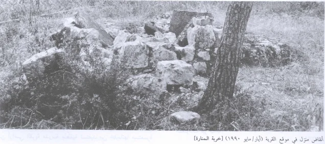
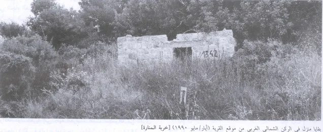
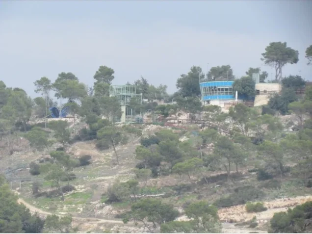
In Walid Khalidi's field description, a regional school occupied a fenced section of the village site. The remains of one house stood among cypress trees inside the enclosure, while four additional stone houses survived among cypress trees outside it.
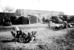
Cactus and almond trees also grew at the site, and the ruins of two additional houses were scattered near its southern section. Khalidi also recorded another house near a well approximately half a kilometer from the main site.
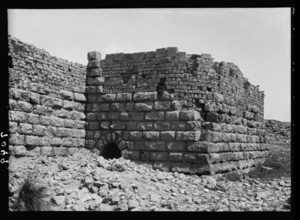
Palestine Remembered reproduces photographs associated with the All That Remains documentation dated 1990, including images of ruined houses and a general view of the village site. Khalidi's description therefore reflects the condition of Khirbat al-Manara during the fieldwork period preceding the book's publication in 1992 and should not be treated as a comprehensive direct field verification of the site in 2026.
Sources
- PalQuest – Interactive Encyclopedia of the Palestine Question: Khirbat al-Manara
- Palestine Remembered – Khirbat al-Manara, Haifa District
- Walid Khalidi – All That Remains: Khirbat al-Manara
- PalQuest – al-Tantura, for verification of the neighboring village's capture date and attacking unit
- PalQuest – Ijzim, for verification of the combined 1931 census unit
- Palestinian Village Encyclopedia – Khirbat al-Manara, for additional local material concerning education and economic life
Photo gallery

Photos from the village's people
Photos sent in by visitors and published after review.
Add a photo of this village
Log in to add photos of this village.
Other villages from Haifa
More from the archive



 Download Our Palestine App
The whole archive in the palm of your hand: depopulated villages, the Nakba, the massacres and Al-Aqsa — free, with no ads to erase the story.
Download Our Palestine App
The whole archive in the palm of your hand: depopulated villages, the Nakba, the massacres and Al-Aqsa — free, with no ads to erase the story.



Comments
No comments yet — be the first to write one.
Add your comment
Name and email are optional. Comments appear after review.