
The depopulated village of Wadi 'Ara / District of Haifa
Wadi 'Ara
About the depopulated village of Wadi 'Ara
- District
- Haifa
- Date Wadi 'Ara was occupied
- 27 February 1948
- Population in 1948
- 270
- Distance from the governorate centre
- Arab Liberation Army
- Elevation above sea level
- 75 m
- Extent of destruction
- The village has been mostly destroyed with the exception of two village houses.
- Ethnic cleansing
- On 27th of February 1948, Wadi 'Ara was mostly ethnically cleansed, and few villagers were allowed to stay until July 1949, then the village was completely cleansed.
- Settlements built on the land of Wadi 'Ara before 1948
- Ein Iron
Hover a dot to read the village name, or click to open its card.
Borders of the depopulated village of Wadi 'Ara
Wadi 'Ara – A Depopulated Palestinian Village in the Haifa Subdistrict
Wadi 'Ara was a Palestinian village in the Haifa Subdistrict, located approximately 38.5 km south of Haifa at an average elevation of about 75 meters above sea level.
The village itself must be distinguished from the much broader geographical region also known as Wadi 'Ara, which contains numerous Palestinian towns and villages along the natural corridor between the coastal plain and Marj ibn 'Amir.
Wadi 'Ara stood on an elongated east–west hill overlooking the wadi of the same name to the north. Another broad valley extended south of the village. Its position at the western entrance to the Wadi 'Ara corridor gave it considerable strategic importance.
- Subdistrict
- Haifa
- Distance from Haifa
- Approximately 38.5 km south
- Elevation
- Approximately 75 m above sea level
- Population, 1944/45
- 230
- Estimated population, 1948
- Approximately 267
- Total land area
- 9,795 dunums
- Beginning of major flight
- 27 February 1948
- Final occupation date
- Not securely established by the principal source
- Military force in the February attack
- Haganah / a Jewish force operating from Ma'anit, according to the ALA account cited by Khalidi
- Defenders
- Arab Liberation Army and local Palestinians
- Zionist settlement established on village land before 1948
- 'En 'Iron, 1934
- Israeli settlement established on the village site
- Barkai, 10 May 1949
Location and Geography of Wadi 'Ara
The village stood on an elongated hill running east to west and overlooked Wadi 'Ara to the north.
A second broad valley lay to the south. The village's strategic significance came from its control over the western entrance to the Wadi 'Ara passage linking the Mediterranean coastal plain with Marj ibn 'Amir.
Wadi 'Ara lay close to the Hadera–'Afula highway, which ran southwest–northeast and intersected the Haifa–Jenin road approximately 13 km northeast of the village.
Another road passed near the wadi and ran westward toward the coastal highway.
Neighboring Villages
Later Palestinian local documentation places the village approximately among the following localities:
- North: Kafr Qari'.
- East: 'Ar'ara and Umm al-Qutuf.
- West: the encampments of 'Arab al-Dumayri.
- South: Maysara and Baqa al-Gharbiyya.
These are approximate geographical relationships rather than detailed cadastral boundaries.
Name of Wadi 'Ara
The village was named after Wadi 'Ara, the valley immediately north of the settlement.
The deeper linguistic origin of the word 'Ara is uncertain. Mustafa Murad al-Dabbagh proposed several possibilities, including connections with an Arabic or Semitic root associated with seeking, expanding, or containing, and a possible interpretation meaning “the bare valley.”
The village's naming after the wadi is secure; the more ancient etymology of 'Ara remains interpretive.
Wadi 'Ara in Historical Sources
The Muslim geographer Ibn Khurdadhbi, who died in 912 CE, described the locality as a stopping place on the route between al-Lajjun and Qalansuwa, reflecting the long-standing importance of the Wadi 'Ara passage.
In the late nineteenth century, the Survey of Western Palestine described a small hamlet in the area known as Khirbat al-Zabadna.
During the British Mandate, Wadi 'Ara was classified as a hamlet in the Palestine Index Gazetteer.
Built Form
According to Khalidi, the village had a roughly square plan and its houses were constructed of masonry.
A later Palestinian local source gives a different account and describes inhabitants as living in tents. Because Khalidi's principal village entry explicitly records masonry houses, that description is given priority here, while the conflicting local tradition is noted rather than silently combined with it.
The village was very small: the official 1931 census recorded only 18 occupied houses.
Population of Wadi 'Ara
The official 1922 Census of Palestine recorded 68 inhabitants, all Muslims.
In the 1931 census, the population increased to 81, again all Muslims, living in 18 occupied houses.
The 1944/45 Village Statistics recorded 230 Arabs.
Salman Abu Sitta's register gives an estimated 1948 population of approximately 267. This is a retrospective demographic estimate rather than an official Mandate census.
The current Palestine Remembered page displays 4,267 for 1948. That figure is inconsistent with the 1945 population, the village's scale, and Abu Sitta's register, which gives 267. It is therefore treated here as a typographical or data-entry error.
Palestine Remembered estimates the number of refugees and their descendants at 1,638 in 1998.
- 192268Official census; all Muslims
- 193181Official census; all Muslims
- 1944/45230Official British Mandate statistics
- 1948Approximately 267Later estimate in the register of depopulated localities; not an official census
- 19981,638 refugeesLater estimate of refugees and their descendants
Number of Houses
- 193118Occupied houses recorded in the official census
Palestine Remembered currently displays 948 houses for 1948. This figure is incompatible with the village's population and is unsupported by the principal sources, so it has not been used.
Education and Services
Khalidi's principal entry does not document a school, mosque, health center, or other independent public-service building in Wadi 'Ara.
A later Palestinian local source states that the village had no separate mosque, school, clinic, or shop and that residents depended on services in nearby Kafr Qari'.
Because this detail is not supplied by the principal village source, it is presented here as local documentation rather than as independently established Mandate administrative data.
Land Ownership in Wadi 'Ara
The total village land area in the 1944/45 Village Statistics was 9,795 dunums.
Palestine Remembered presents the simplified ownership categories as follows:
- Palestinian7,846 dunums80%
- Transferred to Zionists1,949 dunums20%
- Communal/Public0 dunums0%
The official Village Statistics use the original categories Arab and Jewish: 7,846 dunums were classified as Arab land and 1,949 as Jewish land, with no public land listed for the village unit.
Land Use in 1944/45
- Arab
- Jewish
- Cereals8,349 dunums
- Non-cultivable land1,446 dunums
Cultivable land totaled 8,349 dunums, about 85 percent of the total village area, and the official table classifies all of it as cereal land.
The remaining 1,446 dunums were classified as non-cultivable Arab land.
Economic Life
Agriculture and animal husbandry formed the principal basis of the village economy.
In 1944/45, cereal cultivation covered 8,349 dunums across the Arab and Jewish ownership categories: 6,400 Arab and 1,949 Jewish dunums.
The official land-use figures reproduced by PalQuest do not record separate citrus or irrigated-orchard categories for the village.
Water
Village life was connected with the wadi and with springs in the surrounding area.
Later local Palestinian documentation records a group of springs known as 'Uyun al-Asawir, from which villagers obtained water for drinking, cooking, and livestock.
Khalidi does not provide a detailed list of these water sources, so their names are presented as local geographical documentation.
Archaeological Sites
Tall al-Asawir lay northwest of the village. It was a low archaeological mound covering approximately 30 dunums.
Excavations conducted in 1953 uncovered burial caves dating from roughly the fourth to the second millennium BCE.
Later Palestinian local documentation also identifies sites including Khirbat Bidus, with a cave, cisterns, a rock-cut cemetery, and an olive press, as well as al-Rusayyisa, Khirbat al-Burayj, Khirbat al-Nasiriyya, and al-Tawila.
These locally documented sites do not all receive the same degree of treatment in Khalidi's principal entry and should therefore be studied individually before assigning them firm archaeological chronologies.
Early Flight in February 1948
Wadi 'Ara experienced one of the earliest major population departures in the area.
Khalidi, citing Israeli historian Benny Morris, states that the villagers fled on 27 February 1948 out of fear of an attack.
An Arab source cited by Khalidi provides a possible military context. Arab Liberation Army commander Fawzi al-Qawuqji recorded that a Jewish force operating from Ma'anit attacked Palestinian villagers in the Wadi 'Ara area during the night of 27–28 February 1948.
The ALA dispatched a company to protect the inhabitants. It engaged Haganah forces at dawn and nearly reached Ma'anit before British troops intervened.
Al-Qawuqji's account reported one casualty among local Palestinians, three among the ALA, and twenty-five among the Haganah.
Was Wadi 'Ara Finally Occupied on 27 February 1948?
Several secondary sources list 27 February as the village's occupation date. Khalidi's account is more cautious.
He identifies 27 February as the date on which villagers began fleeing, then records continued fighting in the area and explicitly concludes that it is not clear when the village was finally occupied.
On 8 May 1948, al-Qawuqji reported that ALA forces were still engaged in heavy fighting in the Wadi 'Ara area.
The following day, a Haganah force accompanied by armored cars advanced from 'En ha-Shofet into the Wadi 'Ara region. ALA detachments resisted the attack and forced the force to withdraw.
For this reason, 27 February is best recorded as the date of the early attack and major flight, while the final occupation date remains uncertain.
- 27 February 1948
Beginning of major flight
Most villagers reportedly fled out of fear of attack
- Night of 27–28 February 1948
Attack in the Wadi 'Ara area
Jewish force operating from Ma'anit clashed with the ALA and local Palestinians
- 8 May 1948
Continued fighting
ALA records continued engagements in the Wadi 'Ara area
- 9 May 1948
Haganah advance
Armored force penetrated the area but was forced to withdraw by ALA detachments
- Uncertain
Final occupation
Khalidi explicitly states that the eventual date of occupation is unclear
Wadi 'Ara and the 1949 Armistice
By the end of the war, the Wadi 'Ara region lay close to the boundary between Jordanian-held and Israeli-held territory.
Under the Jordanian–Israeli Armistice Agreement signed on 3 April 1949, a substantial area in the Wadi 'Ara region was transferred under duress to Israel. Khalidi considers it possible that some of the village's lands were included.
Khalidi also cites Morris as referring to residents of the Wadi 'Ara region who remained in their villages until at least July 1949 and whom Israel did not expel at that stage because of international political considerations.
This should not be interpreted as proof that inhabitants of Wadi 'Ara village itself specifically remained there until July 1949; the source refers to residents of the broader region.
Zionist and Israeli Settlements on Village Lands
'En 'Iron: Established in 1934 on land traditionally belonging to Wadi 'Ara, before the Nakba.
Ma'anit: Established in 1942 immediately south of the site, but according to Khalidi it was not built on Wadi 'Ara village land.
Barkai: Established directly on the former village site on 10 May 1949.
Wadi 'Ara Today
According to Walid Khalidi's field description in All That Remains, Kibbutz Barkai occupied the former village site.
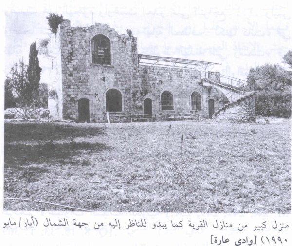
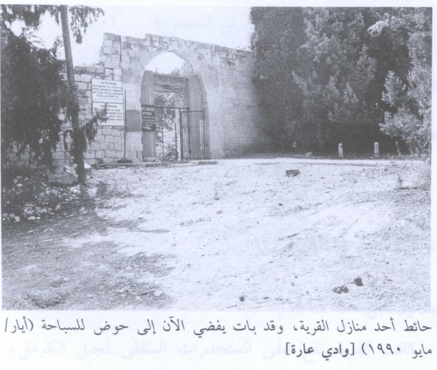
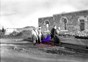
Two Palestinian village houses remained on the eastern edge of the site. One had arched windows and a spiral staircase leading to a rooftop room. The other had a large entrance that was being used as the gateway to the kibbutz swimming pool.
Fig trees and cactus grew east of the surviving houses.
The PalQuest photographs supporting this description are dated May 1990. The description therefore documents the site at that time and should not be treated as direct field verification of the two houses' condition in 2026.
Later community documentation includes a March 2008 visit by the Palestinian heritage organization Dayruna to 'Uyun al-Asawir and Khirbat Wadi 'Ara, as well as more recent local studies of the area's khirbas and historical land geography. These materials document continued identification of the site but do not constitute a comprehensive current architectural survey.
Sources
- PalQuestPalQuest – Interactive Encyclopedia of the Palestine Question: Wadi 'Ara
- Palestine RememberedPalestine Remembered – Wadi 'Ara, Haifa
- Palestine RememberedPalestine Remembered – Wadi 'Ara entry from All That Remains
- Institute for Palestine StudiesInstitute for Palestine Studies – Walid Khalidi, All That Remains
- pcbs.gov.psGovernment of Palestine – Census of Palestine 1922
- fada.birzeit.eduBirzeit University Repository – Census of Palestine 1931
- maktabatsabil.comGovernment of Palestine – Village Statistics 1945: Haifa Sub-District, Population and Land Ownership
- palqura.comPalestinian Villages Encyclopedia – Wadi 'Ara: archaeology, water, services, and local documentation
- plands.orgSalman Abu Sitta – Register of Depopulated Localities in Palestine
Photo gallery

Photos from the village's people
Photos sent in by visitors and published after review.
Add a photo of this village
Log in to add photos of this village.
Other villages from Haifa

More from the archive



 Download Our Palestine App
The whole archive in the palm of your hand: depopulated villages, the Nakba, the massacres and Al-Aqsa — free, with no ads to erase the story.
Download Our Palestine App
The whole archive in the palm of your hand: depopulated villages, the Nakba, the massacres and Al-Aqsa — free, with no ads to erase the story.



Comments
No comments yet — be the first to write one.
Add your comment
Name and email are optional. Comments appear after review.