
The depopulated village of Khirbat al-Mansura / District of Haifa
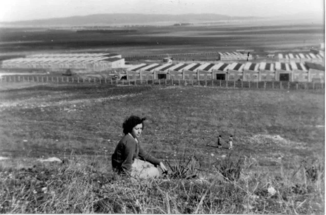
Khirbat al-Mansura
About the depopulated village of Khirbat al-Mansura
- District
- Haifa
- Date Khirbat al-Mansura was occupied
- 28 April 1948
- Population in 1948
- 223
- Military operation
- Coastal Clearing
- Brigade that carried it out
- The Carmeli Brigade
- Elevation above sea level
- 100 m
Hover a dot to read the village name, or click to open its card.
Borders of the depopulated village of Khirbat al-Mansura
Khirbat al-Mansura – Depopulated Palestinian Village of the Haifa District
Khirbat al-Mansura was a depopulated Palestinian hamlet in the Haifa District. It stood on a rounded hill on the northeastern slopes of Mount Carmel, overlooking Marj Ibn Amir to the east and north. It was approximately 18.5 kilometers southeast of Haifa and had an average elevation of about 100 meters above sea level.
The Palestine Index Gazetteer classified Khirbat al-Mansura as a small hamlet, and Walid Khalidi records that most of its inhabitants were Druze. The community was depopulated during the Nakba and the 1948 occupation of Palestine, most probably in the last week of April, amid Haganah and Carmeli Brigade operations in the hinterland of Haifa following the fall of the city.
Location and Geography
Khirbat al-Mansura occupied the summit of a rounded hill on the northeastern edge of Mount Carmel and overlooked the Marj Ibn Amir plain to the east and north.
It lay approximately 18.5 kilometers southeast of Haifa at an average elevation of about 100 meters above sea level.
Supporting Palestinian local documentation places al-Jalama to the north and the Palestinian Arab Druze towns of Isfiya and Daliyat al-Karmil to the northwest. The hamlet was geographically and socially connected with the Druze communities of Mount Carmel.
Tall Qamun lay roughly one kilometer from the site. There is a textual discrepancy in PalQuest: the Arabic version places it southwest of Khirbat al-Mansura, while the English version says southeast. The direction is therefore left unresolved here rather than choosing one version without stronger evidence.
Settlement and Inhabitants
The Palestine Index Gazetteer classified Khirbat al-Mansura as a hamlet rather than a large village. This helps explain why separate statistical data for the settlement are much more limited than for larger villages in the Haifa District.
Walid Khalidi states that the inhabitants were predominantly Druze. The principal sources reviewed do not provide a separate religious breakdown for Khirbat al-Mansura itself.
Population and Houses
Population figures for neighboring Daliyat al-Karmil must not be presented as if they represented Khirbat al-Mansura alone.
| Year | Population / Houses | Note |
|---|---|---|
| 1931 | 1,173 inhabitants; 236 houses | Official combined figure for Daliyat al-Karmil, Deir al-Muhraqa, and Khirbat al-Mansura; it does not represent Khirbat al-Mansura alone |
| 1948 | About 223 | Later estimate, not an official British census conducted in 1948 |
| 1998 | About 1,368 refugees and descendants | Later demographic estimate published by Palestine Remembered |
The principal sources reviewed do not provide a reliable separate house count for Khirbat al-Mansura in either 1931 or 1948. The official 1931 house figure was reported only for the combined group of settlements.
Land and Agriculture
No independent 1944/45 land-ownership and land-use table for Khirbat al-Mansura was found in the official material reviewed for this article.
Figures registered under Daliyat al-Karmil or other neighboring communities should therefore not be reassigned to Khirbat al-Mansura. There is insufficient evidence to construct separate tables for cereals, orchards, olives, built-up land, or ownership categories specifically for the hamlet.
Rather than fill these gaps by inference, the land statistics are left unspecified.
Education, Religious Buildings, and Water
Walid Khalidi's entry and the principal sources reviewed do not provide reliable documentation for an independent school in Khirbat al-Mansura or for a documented number of pupils.
They likewise do not provide sufficient evidence to identify a particular mosque, shrine, well, or spring belonging specifically to the hamlet. Such details have therefore not been added without corroboration.
Archaeological Remains
Although Khirbat al-Mansura has not been securely identified with a known ancient historical settlement, Khalidi records clear evidence that the site itself was old.
Remains included ruined building foundations and rock-cut tombs within and around the village site.
The principal sources do not establish a secure archaeological date for these remains, so they should not automatically be assigned to the Roman, Byzantine, or another specific period without further archaeological evidence.
The Fall of Haifa and the Military Context
The fall of Haifa in April 1948 was followed by the expansion of Haganah operations into the city's surrounding villages and hinterland in order to consolidate control over the area.
Khirbat al-Mansura lay within this broader Mount Carmel–Marj Ibn Amir zone, and its depopulation is associated with the military operations that followed the fall of Haifa during the final week of April.
Operation Bi'ur Hametz
Operation Bi'ur Hametz formed part of the broader Operation Misparayim (“Scissors”), which was intended to strengthen Haganah control over Haifa and its surrounding area.
PalQuest dates Operation Bi'ur Hametz from 22 to 24 April 1948, identifies the Carmeli Brigade as the principal Zionist formation involved, and explicitly includes Khirbat al-Mansura among the affected Palestinian localities, together with al-Rihaniyya and Umm al-Zinat.
Haganah forces, particularly Carmeli Brigade units, continued to operate throughout the final week of April in the hinterland surrounding Haifa in order to consolidate control of the city and its approaches.
Operation Bi'ur Hametz in the Haifa area should not be confused with Operation Hametz, a separate Haganah operation directed against the Palestinian villages surrounding Jaffa.
Occupation and Depopulation
Walid Khalidi does not give a firmly established exact day for the occupation of Khirbat al-Mansura. He states that most villages in the area were occupied after the fall of Haifa and considers it likely that Khirbat al-Mansura met the same fate, possibly in a Haganah assault connected with Operation Bi'ur Hametz.
Palestine Remembered indexes the occupation date as 28 April 1948 and associates the village with Operation Bi'ur Hametz and the Carmeli Brigade. Other Palestinian compilations give nearby dates in the final week of April.
Because PalQuest formally dates Operation Bi'ur Hametz to 22–24 April while the later village index gives 28 April, it is safer not to present a single exact occupation date as conclusively established. Khirbat al-Mansura was depopulated and came under Haganah control in the last week of April 1948, in the context of Operation Bi'ur Hametz and the continuing military actions in its immediate aftermath around Haifa.
The Carmeli Brigade is firmly associated with the operation, but the village-specific sources do not identify a particular battalion as the unit that entered Khirbat al-Mansura.
Occupation Chronology
- April 1948
Fall of Haifa and expansion into the hinterland
The fall of Haifa was followed by expanding Haganah operations against surrounding Palestinian localities.
- 22–24 April 1948
Operation Bi'ur Hametz
A Haganah operation carried out primarily by the Carmeli Brigade. PalQuest explicitly lists Khirbat al-Mansura among the affected localities.
- Last week of April 1948
Depopulation and occupation of Khirbat al-Mansura
Khalidi does not establish an exact day. Palestine Remembered indexes 28 April, while other Palestinian sources give nearby dates.
- April 1948
Military unit
Haganah forces, particularly the Carmeli Brigade at the operational level. No village-specific battalion has been securely identified.
- Exact date not documented
Destruction of the houses
The houses later disappeared completely, but the principal sources do not provide a documented date for their demolition.
Israeli Settlements on Village Lands
Walid Khalidi does not identify an Israeli settlement as having been established on the lands of Khirbat al-Mansura.
Instead, the village lands were incorporated into the lands of the Palestinian Arab Druze town of Daliyat al-Karmil. Daliyat al-Karmil should therefore not be described as a post-1948 Israeli settlement constructed on Khirbat al-Mansura's lands.
Khirbat al-Mansura Today
According to the field description published in Walid Khalidi's All That Remains, no traces of the village houses remained when the site was surveyed.
A farmer from the Palestinian Arab town of Isfiya had constructed grain-storage buildings approximately 200 meters south of the site, while the village lands had been incorporated into those of Daliyat al-Karmil.
This is not a field verification of conditions in 2026. Field research for the All That Remains project was carried out between 1987 and 1990. The description therefore records conditions during that survey period, and the principal sources reviewed here do not provide a comprehensive recent field survey of the site.
Sources
- PalQuest – Interactive Encyclopedia of the Palestine Question: Khirbat al-Mansura
- PalQuest – Operation Bi'ur Hametz
- Palestine Remembered – Khirbat al-Mansura, Haifa District
- Census of Palestine 1931 – Haifa Subdistrict
- Palestinian Villages Encyclopedia – Khirbat al-Mansura; supporting local Palestinian documentation
- PalQuest – All That Remains: Methodology
Photo gallery


Photos from the village's people
Photos sent in by visitors and published after review.
Add a photo of this village
Log in to add photos of this village.
Other villages from Haifa

More from the archive



 Download Our Palestine App
The whole archive in the palm of your hand: depopulated villages, the Nakba, the massacres and Al-Aqsa — free, with no ads to erase the story.
Download Our Palestine App
The whole archive in the palm of your hand: depopulated villages, the Nakba, the massacres and Al-Aqsa — free, with no ads to erase the story.



Comments
No comments yet — be the first to write one.
Add your comment
Name and email are optional. Comments appear after review.