
The depopulated village of Al-Fatur / District of Baysan

Al-Fatur
About the depopulated village of Al-Fatur
- District
- Baysan
- Date Al-Fatur was occupied
- 12 May 1948
- Population in 1948
- 130
- Military operation
- Operation Gideon
- Brigade that carried it out
- Golani Brigade
- Who defended the village
- Arab Liberation Army
- Distance from the governorate centre
- 11.5 (km) South of Baysan
- Elevation above sea level
- -255 m
- Cause of displacement
- Massacre occured by Zionist troops against the town's inhabitants.
- Extent of destruction
- al-Fatur was completely destroyed, and only house rubble left behind.
- Ethnic cleansing
- In mid February 1948, al-Fatur inhabitants were mostly terrorized and displaced out of their homes by the racist Zionists.
Hover a dot to read the village name, or click to open its card.
Borders of the depopulated village of Al-Fatur
Al-Fatur – A Depopulated Palestinian Village in the Baysan Subdistrict
Al-Fatur, also known as 'Arab al-Fatur, was a Palestinian village in the Baysan Subdistrict, situated at the far southern edge of the district near the Tubas boundary, approximately 11.5 km south of Baysan.
The village stood on a level plain that gradually sloped westward and overlooked wide expanses of the Jordan Valley to the east. PalQuest gives its average elevation as approximately 225 meters below sea level, while later Palestinian local sources citing Mustafa Murad al-Dabbagh give approximately 199 meters below sea level.
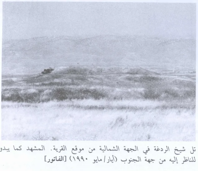
Two prominent tells bordered the village: Tall Shaykh al-Fatur and Tall Shaykh Radgha. Tall Shaykh al-Fatur contained a well constructed with ancient building materials. A dirt path linked the village with the Baysan–Jericho highway west of the site.
- Subdistrict
- Baysan
- Alternative name
- 'Arab al-Fatur
- Distance from Baysan
- Approximately 11.5 km south
- Average elevation
- Approximately 225 m below sea level according to PalQuest
- Population, 1931
- 66, all Muslims
- Population, 1944/45
- 110
- Estimated population, 1948
- 128
- Total land area
- 729 dunums
- Depopulation date
- Uncertain; possibly mid-February or during Operation Gideon, 10–15 May 1948
- Military operation associated with the village
- Operation Gideon
- Operation-level military force
- Haganah's Golani Brigade
- Israeli settlements founded on village land
- None identified by Walid Khalidi
Location and Geography of Al-Fatur
Al-Fatur lay at the southern extremity of the Baysan Subdistrict, close to the boundary with the Tubas area.
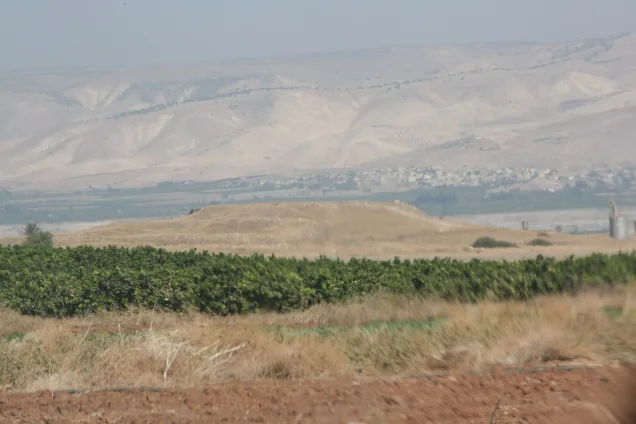
The village occupied level ground that descended gradually toward the west while overlooking a wide area of the Jordan Valley to the east.
The main Baysan–Jericho road passed west of the village, which was connected to it by a dirt track.
Neighboring Areas
Later Palestinian local sources describe al-Fatur as lying along the Tubas boundary and adjoining lands associated with al-Hamra and Tubas.
Schematic Palestinian village maps additionally place al-Khunayzir approximately to the north, Bardala in the broader western direction, the Jordan Valley and river area to the east, and 'Ayn al-Bayda to the south.
These are approximate geographical relationships and should not be treated as substitutes for detailed historical cadastral boundaries.
Name of Al-Fatur
The locality also appears in official records as 'Arab al-Fatur.
Some Palestinian local sources associate the word Fatur with the Arabic root f-t-r, conveying the sense of splitting or fissuring. E. H. Palmer similarly interpreted the nineteenth-century place-name in relation to fissures, rocks, and a spring.
Khalidi does not provide a definitive etymology, so this should be treated as a probable linguistic interpretation rather than a conclusively documented origin.
Al-Ghurair and 'Arab al-Saqr
Palestinian village documentation identifies the al-Ghurair clan as inhabitants of al-Fatur.
Later oral testimony by a former resident describes al-Ghurair as belonging to 'Arab al-Saqr, or al-Suqur, one of the Bedouin tribal groupings historically associated with the Baysan plains.
The official 1931 census designation “'Arab al-Fatur” itself reflects the tribal character of the settlement, although the census does not provide a complete clan genealogy.
Built Form
Al-Fatur was an exceptionally small rural settlement compared with many other villages of the Baysan Subdistrict.
The official 1931 census recorded only 16 occupied houses.
The 1944/45 official land-use table does not provide a separate built-up-land figure, likely reflecting the small size and rural tribal character of the settlement.
Population of Al-Fatur
The principal sources used here do not provide a secure standalone 1922 population figure for al-Fatur, so no uncertain number has been added for that year.
The official 1931 Census of Palestine recorded 66 inhabitants in 'Arab al-Fatur—40 males and 26 females—all Muslims, living in 16 occupied houses.
By 1944/45, the population had increased to 110, all Arab Muslims.
Palestine Remembered later estimated the population at 128 in 1948 and the number of refugees and their descendants at 784 in 1998. These are retrospective estimates rather than official Mandate census counts.
- 193166Official census; all Muslims
- 1944/45110Official statistics; all Arab Muslims
- 1948128Later Palestine Remembered estimate, not an official census
- 1998784 refugeesLater estimate of refugees and their descendants
Number of Houses
- 193116Occupied houses recorded in the official census
- 194831Later Palestine Remembered estimate, not an official census count
Education and Public Services
Khalidi and PalQuest do not document a formal school, mosque, clinic, or other independent public institution in al-Fatur.
Because the village was small and retained a strongly tribal rural character, such facilities should not be assumed without direct evidence.
This article therefore does not add an undocumented school, mosque, or health facility.
Land Ownership in Al-Fatur
The total land area recorded for al-Fatur in the 1944/45 Village Statistics was 729 dunums.
Using Palestine Remembered's simplified terminology, ownership can be presented as follows:
- Palestinian709 dunums97%
- Transferred to Zionists0 dunums0%
- Communal/Public20 dunums3%
The official Village Statistics use the original categories Arab and Public: 709 dunums were Arab land and 20 dunums were public. No land was recorded under the Jewish category.
Land Use in 1944/45
- Arab
- Public
- Cereals709 dunums
- Non-cultivable land20 dunums
Cultivable land totaled 709 dunums, approximately 97 percent of the entire village area, and the official table classifies all of it as cereal land.
The remaining 20 dunums, approximately 3 percent, were classified as non-cultivable public land.
Some later Palestinian local sources mention a very small area of olive cultivation and land used for roads and wadis. These do not appear as separate categories in the official land-use table used here and have therefore not been added to the statistical total.
Economic Life
Agriculture was the principal source of livelihood in al-Fatur.
Cereals were the dominant crop: the 1944/45 Village Statistics classify 709 dunums as cereal land.
Khalidi also notes that villagers cultivated vegetables and other annual crops.
The settlement's location in the Baysan Valley and access to local water sources supported its small agricultural economy.
Water and Springs
'Ayn al-Fatur, or the spring of al-Fatur, was one of the principal landmarks of the village area and lay immediately north of the ruins of Tall Shaykh al-Fatur.
Later local Palestinian sources also preserve the names of springs in the surrounding area, including 'Uyun al-Bulaybil and al-Dayr, as well as 'Ayn Ghadra nearby.
These detailed names derive from local geographical documentation, while Khalidi directly confirms the spring of al-Fatur.
Tall Shaykh al-Fatur and Tall Shaykh Radgha
Two prominent tells framed the village landscape.
Tall Shaykh al-Fatur contained a well constructed with ancient building materials, indicating older remains or reused archaeological material at the site.
Tall Shaykh Radgha was another prominent mound near the village and appears in later Palestinian photographic documentation.
Khalidi does not provide a secure archaeological chronology for these remains, so they should not be assigned to a specific historical period without independent excavation or study.
The February 1948 Fighting near Tirat Tzvi
Khalidi associates one possible date of al-Fatur's depopulation with fighting around the nearby Zionist settlement of Tirat Tzvi in mid-February 1948.
The clashes involved Zionist forces and the Arab Liberation Army.
Khalidi considers it possible that the villagers were displaced during this fighting, but he does not establish this scenario conclusively.
Operation Gideon and the Depopulation of Al-Fatur
Khalidi's second possibility is that the inhabitants remained for another three months, until the beginning of Operation Gideon.
The Haganah's Golani Brigade carried out Operation Gideon from 10 to 15 May 1948 as the campaign that brought the Baysan Valley under Zionist control and displaced much of its Palestinian population.
PalQuest explicitly lists al-Fatur among the villages affected by the operation.
Palestine Remembered and the Palestinian Villages Encyclopedia list 12 May 1948 as the date of occupation, while later local testimony uses 15 May.
Khalidi's detailed account, however, does not establish 12 May as a certain village-specific occupation date. Instead, it leaves the chronology open between a possible displacement in mid-February and one during Operation Gideon in May.
The most careful formulation is therefore: the exact date of al-Fatur's depopulation is uncertain; it may have occurred in mid-February 1948 or during Operation Gideon between 10 and 15 May.
The securely documented military formation at the operation level is the Haganah's Golani Brigade. The principal village source does not identify a specific battalion that assaulted al-Fatur itself.
- Mid-February 1948
Fighting around Tirat Tzvi
Clashes between Zionist forces and the Arab Liberation Army; one possible point of displacement
- 10 May 1948
Beginning of Operation Gideon
Golani Brigade begins the campaign to occupy the Baysan Valley
- 12 May 1948
Date used by later Palestinian secondary sources
Commonly listed occupation date, but not conclusively established by Khalidi
- 15 May 1948
End of Operation Gideon
End of the principal operation in the Baysan Valley
- 10–15 May 1948
Military force
Golani Brigade at operation level; no village-specific battalion securely identified
Al-Fatur after 1948 and the Armistice Line
Al-Fatur lay close to the area through which the later armistice line passed, making the post-1948 history of its inhabitants more complicated than that of villages situated wholly on one side of the line.
A later Palestinian oral testimony by a member of the al-Ghurair clan states that some residents moved into or remained in a part of the village lands that had not fallen under Israeli control in 1948.
Following the 1949 armistice arrangements, most of the village lands reportedly lay on the Israeli side, while a smaller area remained under Jordanian administration or adjacent to the demarcated no-man's-land zone.
The same local account states that members of al-Ghurair who remained in the area were displaced again in 1967 and moved to Jordan, with some later settling in al-Husn refugee camp.
These details derive from Palestinian oral and community history rather than Khalidi's principal village entry and are therefore presented separately from the core 1948 depopulation chronology.
Israeli Settlements and Al-Fatur's Lands
According to Walid Khalidi, no Israeli settlement was established directly on al-Fatur's village lands.
Tirat Tzvi: Established in 1937 north of al-Fatur, but not on the village's lands.
Mechola: Established in 1968 approximately five kilometers southwest of the former village site. Khalidi states that its inhabitants cultivated some of al-Fatur's lands.
Some Palestine Remembered text conflates the establishment dates of Tirat Tzvi and Mechola. The 1968 date belongs to Mechola; Tirat Tzvi was founded in 1937.
Al-Fatur Today
According to Walid Khalidi's field description in All That Remains, the village had been destroyed.
The surrounding lands were being planted with wheat, while the ruins on Tall Shaykh al-Fatur were overgrown with thorns and doum palms.
The spring of al-Fatur lay immediately north of the ruins.
This description derives from fieldwork conducted before the publication of All That Remains in 1992 and should not be treated as direct field verification of conditions in 2026.
Palestine Remembered contains community photographs from a 2007 visit and later video documentation published in 2021 showing the wider al-Fatur, 'Ayn Ghadra, and Tall Radgha area. A Palestinian newspaper also published a field-based oral-history account in 2023.
These sources demonstrate continued Palestinian identification of and visits to the site, but they do not constitute a comprehensive independent archaeological or architectural survey of al-Fatur in 2026.
Sources
- PalQuestPalQuest – Interactive Encyclopedia of the Palestine Question: al-Fatur
- PalQuestPalQuest – Operation Gideon
- Palestine RememberedPalestine Remembered – al-Fatur, Baysan
- Palestine RememberedPalestine Remembered – al-Fatur entry from All That Remains
- Palestine RememberedPalestine Remembered – local testimony concerning al-Ghurair and al-Fatur after 1948
- Institute for Palestine StudiesInstitute for Palestine Studies – Walid Khalidi, All That Remains
- fada.birzeit.eduBirzeit University Repository – Census of Palestine 1931
- maktabatsabil.comGovernment of Palestine – Village Statistics 1945: Beisan Sub-District, Cultivable Land
- palqura.comPalestinian Villages Encyclopedia – al-Fatur: location, clans, agriculture, and local documentation
- alhaya.psal-Hayat al-Jadida – Al-Fatur: A Village Displaced More Than Once, Palestinian oral-history documentation
Photo gallery

Photos from the village's people
Photos sent in by visitors and published after review.
Add a photo of this village
Log in to add photos of this village.
Other villages from Baysan

More from the archive


 Download Our Palestine App
The whole archive in the palm of your hand: depopulated villages, the Nakba, the massacres and Al-Aqsa — free, with no ads to erase the story.
Download Our Palestine App
The whole archive in the palm of your hand: depopulated villages, the Nakba, the massacres and Al-Aqsa — free, with no ads to erase the story.



Comments
No comments yet — be the first to write one.
Add your comment
Name and email are optional. Comments appear after review.