
The depopulated village of Khirbat Umm Sabuna / District of Baysan
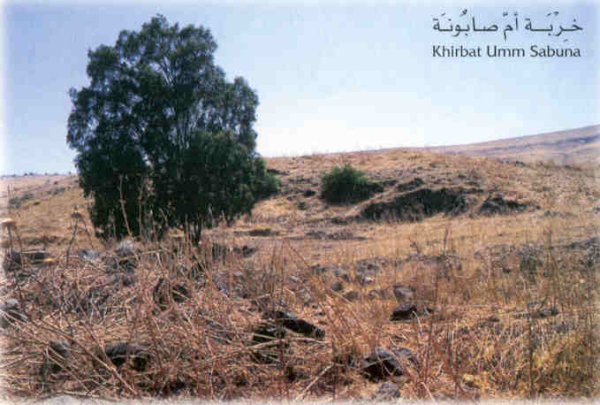
Khirbat Umm Sabuna
About the depopulated village of Khirbat Umm Sabuna
- District
- Baysan
- Date Khirbat Umm Sabuna was occupied
- 21 May 1948
- Population in 1948
- 868
- Military operation
- Operation Gideon
- Brigade that carried it out
- Golani Brigade
- Distance from the governorate centre
- 10.5 (km) Northeast of Baysan
- Elevation above sea level
- -175 (m)
- Cause of displacement
- Influence of fall of, or exoduce from, neighboring town
- Extent of destruction
- TUmm Sabuna was completely destroyed, and only house rubble left behind.
- Ethnic cleansing
- Umm Sabuna, Khirbat inhabitants were completely ethnically cleansed.
- Settlements built on the built-up area of Khirbat Umm Sabuna after 1948
- Neve Ur
Hover a dot to read the village name, or click to open its card.
Borders of the depopulated village of Khirbat Umm Sabuna
Khirbat Umm Sabuna – Depopulated Palestinian Hamlet in Baysan Subdistrict
Khirbat Umm Sabuna was a small Palestinian settlement in the Baysan subdistrict of Galilee. Palestine Remembered and some later databases label it “Khirbat Umm Sabuna ('Arab al-Saqr),” but this designation is partly connected to the way the locality was recorded in the 1931 census, when Umm Sabuna was included within a wider enumeration unit headed by 'Arab al-Saqr. The population of that unit must not be treated as the population of Umm Sabuna alone.
The hamlet stood approximately 10.5 kilometers from Baysan at the western edge of the Jordan Valley, below the steep escarpment on which neighboring Kawkab al-Hawa stood. Its average elevation was approximately 175 meters below sea level, and the Jordan River lay about 3.3 kilometers to the east.
No independent 1944/45 population, land-ownership, or land-use statistics are available for Khirbat Umm Sabuna in Khalidi/PalQuest. Its occupation and depopulation most probably took place during the second half of May 1948 in the context of Operation Gideon and the immediate continuation of the Golani Brigade's campaign in the Baysan Valley.
Key Facts about Khirbat Umm Sabuna
| Field | Information |
|---|---|
| Name | Khirbat Umm Sabuna |
| Alternative database designation | Khirbat Umm Sabuna ('Arab al-Saqr) |
| Subdistrict | Baysan |
| Mandate classification | Hamlet in the Palestine Index Gazetteer |
| Distance from Baysan | Approximately 10.5 km |
| Average elevation | Approximately 175 m below sea level |
| Distance from the Jordan River | Approximately 3.3 km west of the river |
| Population, 1931 | No independent figure; 444 was the population of the broader 'Arab al-Saqr census unit that included Umm Sabuna and several other localities |
| Houses, 1931 | No independent figure; 85 houses belonged to the broader census unit |
| Population, 1944/45 | Not independently available in the principal sources |
| Land area | No independent village-specific figure available |
| Military context | Operation Gideon / immediate continuation of the Golani campaign in the Baysan Valley |
| Occupation date | Uncertain; probably in the second half of May 1948. Palestine Remembered gives 21 May |
| Military unit | Golani Brigade at operational level; no village-specific battalion is independently documented |
| Cause of depopulation | Khalidi considers it probable that residents were driven out at the time of occupation; Palestine Remembered instead classifies the cause as the influence of the fall or exodus of a neighboring locality |
| Extent of destruction | The built-up hamlet was destroyed; only stone rubble remained in Khalidi's field documentation |
| Israeli settlements on village land | None documented |
Location of Khirbat Umm Sabuna
Khirbat Umm Sabuna stood at the western edge of the Jordan Valley, directly below the steep escarpment on which Kawkab al-Hawa was located.
The hamlet faced east toward the Jordan River, approximately 3.3 kilometers away. A wadi running northeast from the site and a nearby spring both carried the name Umm Sabuna.
Kawkab al-Hawa was only about two kilometers away, making its military history particularly relevant when reconstructing the probable fate of Umm Sabuna in May 1948.
The Name and the 'Arab al-Saqr / al-Bashatwa Question
Palestine Remembered and several derivative databases refer to the locality as “Khirbat Umm Sabuna ('Arab al-Saqr).”
This designation is partly explained by the 1931 Census of Palestine. The census recorded a larger enumeration unit under the name 'Arab al-Saqr and included beneath it Umm Sabuna, Abu Qarmula, Wadi Shubash, al-Khor, Sdud al-Sharqiyya, Sdud al-Fawqa, and Tall al-Shuqaf.
The census grouping does not by itself demonstrate that every resident of Umm Sabuna belonged to 'Arab al-Saqr, nor does it permit the combined population of the unit to be assigned to Umm Sabuna alone.
Meanwhile, the Palestinian Encyclopedia, drawing on Mustafa Murad al-Dabbagh, describes the wider territory of the al-Bashatwa communities in northern Baysan and explicitly connects their settlements and agricultural areas with the khirbas of al-Mazar, al-Zawiya, al-Ziwan, and Umm Sabuna.
This article therefore uses the primary geographical name “Khirbat Umm Sabuna” and treats “'Arab al-Saqr” as a designation connected with Mandate census organization and some later databases rather than as a definitive statement about the tribal affiliation of every inhabitant.
Population of Khirbat Umm Sabuna
The principal sources do not provide a reliable independent population series for Khirbat Umm Sabuna itself.
| Year | Figure | Notes |
|---|---|---|
| 1931 | 444 | Combined population of the broader 'Arab al-Saqr census unit, which included Umm Sabuna and several other localities; not the population of Umm Sabuna alone |
| 1944/45 | Not available | Khalidi and PalQuest provide no independent figure for the hamlet |
| 1948 | 868 | Later estimate displayed by Palestine Remembered; not an official census and not independently verified as specific to Umm Sabuna |
| 1998 | 5,329 | Later Palestine Remembered estimate of refugees and descendants |
The 1948 estimate requires particular caution because the earlier 1931 figure displayed on the same page is itself an aggregate covering several localities.
Number of Houses
The 1931 census recorded approximately 85 houses for the broader 'Arab al-Saqr statistical unit, together with its 444 inhabitants.
Because Umm Sabuna was only one of several localities included in that unit, the 85 houses cannot be presented as a village-specific count. Khalidi does not provide an independent house total for Umm Sabuna.
Village Lands
Khalidi and PalQuest do not provide an independent 1944/45 land-ownership or land-use table for Khirbat Umm Sabuna.
Population and land records in this part of the Baysan Valley were sometimes organized around broader tribal or territorial units. Figures belonging to 'Arab al-Saqr, al-Bashatwa, or neighboring Kawkab al-Hawa should therefore not be reassigned to Umm Sabuna without independent cadastral documentation.
No unsupported village-specific ownership or agricultural-use table has been constructed in this article.
Economic Life
Khalidi's village entry does not provide independent crop or agricultural-acreage statistics for Umm Sabuna.
The wider northern Baysan Valley depended heavily on farming and pastoralism. The Palestinian Encyclopedia records that the al-Bashatwa communities in this broader geographical zone cultivated cereals, vegetables, and fruit trees, particularly bananas, and also used part of their territory as seasonal grazing land.
Those figures and descriptions relate to the wider al-Bashatwa area and have not been converted into village-specific statistics for Umm Sabuna.
Water and 'Ayn Umm Sabuna
A spring beside the hamlet carried the name 'Ayn Umm Sabuna, and the nearby wadi running northeast from the site also took its name from the locality.
The principal sources do not provide quantitative information concerning the spring's discharge or the precise acreage irrigated from it.
Education and Public Institutions
Neither Khalidi nor PalQuest documents an independent school at Khirbat Umm Sabuna, and no reliable enrollment or founding-year data are available.
The principal village entry likewise does not independently document a mosque, market, or other public institution specific to the hamlet.
Given its small size and classification as a hamlet, institutions belonging to neighboring villages or broader tribal communities should not be transferred to Umm Sabuna without direct evidence.
Archaeological Remains
Fragments of ancient pottery were scattered over the village site.
Foundations of older buildings also protruded from the soil, indicating that the locality had been inhabited during earlier historical periods.
Khalidi's entry does not provide a precise archaeological chronology for these remains, so they have not been assigned to a specific era without specialist evidence.
Operation Gideon
The Haganah's Golani Brigade carried out Operation Gideon between 10 and 15 May 1948. The campaign targeted Baysan and its valley and resulted in the depopulation of numerous Palestinian communities.
PalQuest explicitly lists Khirbat Umm Sabuna among the localities affected by Operation Gideon.
There is, however, an important chronological nuance. PalQuest formally dates Operation Gideon to 10–15 May, while the Umm Sabuna village entry reconstructs its likely occupation by comparison with neighboring Kawkab al-Hawa, which was contested and occupied during the period between 16 and 21 May.
The most precise formulation is therefore that Umm Sabuna fell in the context of Operation Gideon and the immediate continuation of the Golani Brigade's Baysan Valley campaign, rather than forcing its occupation into a specific day within the operation's formal dates.
Occupation and Depopulation
Khalidi's entry contains no independent account of a battle inside Khirbat Umm Sabuna and does not establish an exact day of occupation.
Its location and the fate of neighboring Kawkab al-Hawa suggest that the hamlet was occupied in the second half of May 1948. Kawkab al-Hawa, only about two kilometers away, experienced several phases of fighting between 16 and 21 May as Iraqi forces entered this front and attempted to regain positions west of the Jordan River.
Khalidi considers it probable that Umm Sabuna's population was driven out at approximately the time the hamlet was occupied.
Palestine Remembered gives 21 May as the occupation date, identifies Operation Gideon and the Golani Brigade, and classifies the immediate cause of exodus as the influence of the fall or departure of a neighboring locality.
Because 21 May is not independently established in the principal village narrative, this article uses the more cautious formulation: occupation probably occurred during the second half of May 1948, likely within the 16–21 May period associated with the fighting around Kawkab al-Hawa.
The Golani Brigade is documented as the principal formation responsible for Operation Gideon and the broader Baysan Valley campaign. No specific Golani battalion is independently identified as the unit that entered Umm Sabuna itself.
Ethnic Cleansing
Palestine Remembered describes the final outcome at Umm Sabuna as complete ethnic cleansing.
Khalidi's more specific village account states that the inhabitants were probably driven out around the time of occupation in May 1948. The directly documented conclusion is therefore the complete disappearance of the Palestinian community from the site and the probability of expulsion during occupation, while the term “ethnic cleansing” remains attributed to the source that explicitly applies it.
Occupation Chronology
- 10 May 1948
Beginning of Operation Gideon
The Golani Brigade began its campaign for control of Baysan and the Baysan Valley.
- 15 May 1948
Formal end of Operation Gideon
PalQuest formally dates the operation to 10–15 May and lists Umm Sabuna among the affected localities.
- After 15 May 1948
Arrival of Iraqi forces on this front
Iraqi troops entered the sector and attempted to recover positions, with limited territorial success.
- 16–21 May 1948
Fighting around Kawkab al-Hawa
The neighboring village, only about 2 km away, experienced several phases of fighting and control.
- Second half of May 1948
Probable occupation of Umm Sabuna
Khalidi reconstructs the occupation within this period; Palestine Remembered gives 21 May, but the exact day is not independently established.
- Probably at the time of occupation
Depopulation
Khalidi considers it probable that the inhabitants were driven out when the hamlet was occupied.
- Precise date not documented
Destruction
The settlement was destroyed, leaving only stone rubble at the site.
Israeli Settlements and Khirbat Umm Sabuna's Lands
Khalidi and PalQuest identify no Israeli settlement as having been established directly on Khirbat Umm Sabuna's village lands. After the Nakba, those lands were combined with those of Kawkab al-Hawa.
| Settlement | Established | Relationship to Umm Sabuna |
|---|---|---|
| Neve Ur | 1949 | Located approximately 1 km east of the village site; Khalidi does not state that the settlement itself was built on Umm Sabuna's land, although an orchard belonging to Neve Ur occupies village land |
Neve Ur should therefore not be described as a settlement established directly on the built-up site of Umm Sabuna, even though it later used part of the village lands.
Khirbat Umm Sabuna Today
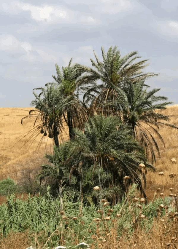
According to Walid Khalidi's field description, only stone rubble remained at the village site.
An orchard belonging to Neve Ur occupied part of the former village lands, while the higher ground surrounding the site was being used for grazing.
This description derives from fieldwork undertaken before the publication of All That Remains in 1992. It is therefore a documented historical description rather than a comprehensive direct field verification of Khirbat Umm Sabuna's condition in 2026.
Sources
- PalQuest – Interactive Encyclopedia of the Palestine Question: Khirbat Umm Sabuna
- PalQuest – Operation Gideon
- PalQuest – Kawkab al-Hawa, for the military chronology of the immediate area
- Palestine Remembered – Khirbat Umm Sabuna, Baysan District
- Walid Khalidi – All That Remains: Khirbat Umm Sabuna
- Palestinian Encyclopedia – al-Bashatwa, drawing on Mustafa Murad al-Dabbagh
- Government of Palestine – Census of Palestine 1931, Baysan Sub-District
- Institute for Palestine Studies – All That Remains, Walid Khalidi
Photo gallery

Photos from the village's people
Photos sent in by visitors and published after review.
Add a photo of this village
Log in to add photos of this village.
Other villages from Baysan
More from the archive



 Download Our Palestine App
The whole archive in the palm of your hand: depopulated villages, the Nakba, the massacres and Al-Aqsa — free, with no ads to erase the story.
Download Our Palestine App
The whole archive in the palm of your hand: depopulated villages, the Nakba, the massacres and Al-Aqsa — free, with no ads to erase the story.



Comments
No comments yet — be the first to write one.
Add your comment
Name and email are optional. Comments appear after review.