
The depopulated village of Zab'a / District of Baysan
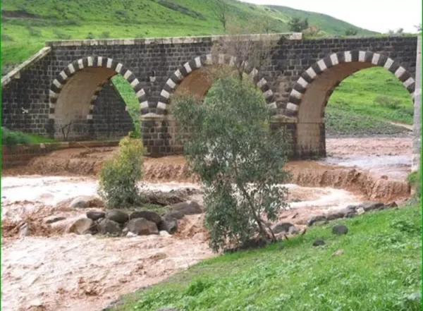
About the depopulated village of Zab'a
- District
- Baysan
- Date Zab'a was occupied
- 12 May 1948
- Population in 1948
- 200
- Military operation
- Operation Gideon
- Brigade that carried it out
- Golani Brigade
- Distance from the governorate centre
- 5.5 km Northeast of Baysan
- Elevation above sea level
- -255 m
- Extent of destruction
- The village was completely defaced
- Ethnic cleansing
- Zab'a inhabitants were completely ethnically cleansed.
- Settlements built on the land of Zab'a before 1948
- Beit Yosef
- Settlements built on the built-up area of Zab'a after 1948
- Havat Deshen (Farm
Hover a dot to read the village name, or click to open its card.
Borders of the depopulated village of Zab'a
Zab'a – Baysan Subdistrict
Zab'a was a depopulated Palestinian village in the Baysan subdistrict, located approximately 5.5 km northeast of Baysan on Wadi Yubla, also known as Wadi al-'Ashsha, at an average elevation of about 225 meters below sea level.
The Baysan–Jericho highway and the railway from Haifa to Samakh, which ultimately connected with the Hijaz Railway, passed immediately east of the village. Fertile soil, abundant water, and access to transport routes gave the locality considerable agricultural importance.
Zab'a had 147 inhabitants in the official 1931 census and 170 in 1944/45. Its registered lands totaled 3,968 dunums, but by 1945 only 156 dunums remained in Arab ownership, while 3,424 dunums were registered in Jewish ownership.
Palestine Remembered indexes 12 May 1948 as the date on which Zab'a was occupied during Operation Gideon, the Golani Brigade campaign to seize the Baysan Valley and depopulate its Palestinian communities.
Location of Zab'a
Zab'a stood along Wadi Yubla, also known as Wadi al-'Ashsha, where the wadi entered the Jordan Valley.
The village lay approximately 5.5 km northeast of Baysan and about 225 meters below sea level.
The Baysan–Jericho highway and the Haifa–Samakh railway passed directly to the east.
Village Layout
The Palestine Index Gazetteer classified Zab'a as a hamlet.
Its adobe houses and narrow alleys formed a generally rectangular plan extending northwest to southeast.
The buildings were positioned away from the wadi, probably to reduce exposure to winter flooding.
Neighboring Villages and Areas
| Direction | Village / Area |
|---|---|
| North | Khirbat Umm Sabuna / 'Arab al-Saqr |
| West / Northwest | Jabbul |
| East | Jordan River and the lands extending toward it |
| South | 'Arab al-Bawati / Khirbat al-Hakimiyya |
Palestine Remembered also lists al-Hamidiyya and the Bashatwa lands among the surrounding areas.
Original cadastral maps remain the best evidence for exact village boundaries.
Population
- 1931147Official Census of Palestine; 37 occupied houses. A transcription of the census gives 146 Muslims and one Jewish resident
- 1944/45170Official statistics; all 170 were recorded as Muslims
- 1948197Later Palestine Remembered estimate; not an official Mandate census
- 1998551 or 1,211Palestinian online sources differ in their refugee estimates; neither figure is treated here as a definitive official census
Number of Houses
- 193137 occupied housesOfficial Census of Palestine
- 194849Later Palestine Remembered estimate; not an official census figure
Land Ownership in 1944/45
Zab'a's registered lands totaled 3,968 dunums.
Using Palestine Remembered's simplified terminology:
- Palestinian156 dunums4%
- Transferred to Zionists3,424 dunums86%
- Communal/Public388 dunums10%
The official categories record 156 Arab dunums, 3,424 Jewish dunums, and 388 Public dunums.
By 1945, therefore, only a small part of the village's registered land remained in Arab ownership.
Land Use in 1944/45
- Arab
- Jewish
- Public
- Cereals3,520 dunums
- Built-up land60 dunums
- Non-cultivable land388 dunums
The land-use figures balance exactly with the official ownership totals.
All 156 dunums remaining in Arab ownership in 1944/45 were devoted to cereal cultivation.
Economic Life in Zab'a
Agriculture was the principal livelihood of the inhabitants.
Before most village land passed into Jewish ownership, the fertile soil and abundant water supported vegetables, fruit, and cereals.
By 1944/45, the remaining 156 Arab-owned dunums were all planted with cereals.
Water and Wadi al-'Ashsha
Zab'a stood directly along Wadi Yubla, or Wadi al-'Ashsha.
Abundant water resources were one of the principal advantages of the village site and supported productive agriculture.
The wadi also posed a seasonal flood risk, which probably influenced the northwest–southeast orientation of the village away from the channel.
The core source does not securely name individual village springs or wells, so none has been added without evidence.
Education and Services
No independent school is securely documented in Khalidi or PalQuest for Zab'a before the Nakba.
Given the village's small size and proximity to Baysan and neighboring communities, residents may have depended on outside services, but no specific school arrangement has been presented without a source.
Religious Life
The 1945 statistics recorded all 170 inhabitants as Muslims.
The 1931 census recorded 147 residents; a transcription of the official table gives 146 Muslims and one Jewish resident.
No specific mosque or named shrine is documented in the core village entry.
Tall Isma'il
Tall Isma'il stood approximately 2 km east of Zab'a.
A Bedouin cemetery occupied the top of the tell.
Khalidi notes that the soft soil of such archaeological mounds, containing remains of earlier settlements, made them attractive locations for burial grounds.
Land Transfer before the Nakba
Zab'a's fertile soil, water resources, and strategic location made its lands an early target for Zionist land acquisition during the British Mandate.
By 1945, only 156 of the village's 3,968 registered dunums remained in Arab ownership, while 3,424 dunums were registered as Jewish-owned.
Beyt Yosef before 1948
In 1937, the settlement of Beyt Yosef was established approximately 2 km northeast of Zab'a.
Khalidi states that it was built on purchased land that had formerly belonged to the village.
The neighboring Jabbul entry independently confirms that Beyt Yosef was established on Zab'a land.
Operation Gideon
Operation Gideon ran from 10 to 15 May 1948.
The Golani Brigade carried out the campaign to seize the Baysan Valley and remove its Palestinian population.
Baysan and numerous Palestinian villages and hamlets across the valley were taken during the offensive.
Occupation and Depopulation of Zab'a
Palestine Remembered indexes 12 May 1948 as Zab'a's occupation date and associates the village with Operation Gideon and the Golani Brigade.
The same day saw the fall of Baysan itself to Golani forces.
The currently accessible PalQuest village page does not provide a detailed village-specific account of the assault or a family-by-family account of departure.
The safest formulation is therefore that Zab'a came under Zionist control on 12 May 1948 during Operation Gideon and that its Palestinian inhabitants were displaced in the course of the Golani Brigade's campaign in the Baysan Valley.
Some later Palestinian compilations give 1 May as the occupation date, but that date predates the formal beginning of Operation Gideon on 10 May and is not adopted here.
Military Unit
The military formation associated with Zab'a's occupation was the Golani Brigade.
The available village-specific sources do not securely identify a particular battalion, so no narrower unit designation has been added.
Possible Irgun participation in Operation Gideon generally does not establish an Irgun role at Zab'a itself.
Occupation Chronology
- Early May 1948
Escalation of Golani operations in the Baysan Valley
The Golani Brigade expanded its campaign against Baysan and surrounding Palestinian communities.
- 10 May 1948
Beginning of Operation Gideon
The offensive began with the objective of taking the Baysan Valley and depopulating its Palestinian communities.
- 12 May 1948
Occupation of Zab'a
Palestine Remembered indexes this date for the village's occupation and associates it with the Golani Brigade.
- 12 May 1948
Fall of Baysan
The district center also fell to Golani forces, accelerating the collapse of Palestinian control across the valley.
- May 1948
Depopulation of Zab'a
The Palestinian population was displaced during the broader Golani campaign; the core sources do not provide a detailed sequence for each family's departure.
- 15 May 1948
Formal end of Operation Gideon
The operation formally ended after the capture of Baysan and numerous surrounding Palestinian localities.
- Later; exact date not established
Destruction of the village
The built-up village was removed, leaving few identifiable traces during the later field survey.
Refugees from Zab'a
Palestine Remembered estimates the village's 1948 population at approximately 197. This is a later demographic estimate rather than an official Mandate census.
Palestinian electronic sources differ substantially regarding the number of refugees and descendants in 1998. Palestine Remembered's current statistics page gives 551, while other Palestinian compilations give approximately 1,211.
Neither figure is treated here as a definitive comprehensive refugee census.
Israeli Settlements on Zab'a Village Lands
| Settlement / Facility | Established | Relationship to Zab'a |
|---|---|---|
| Beyt Yosef | 1937 | Established before the Nakba on purchased land that had formerly belonged to Zab'a, about 2 km northeast of the village site |
| Doshen | 1955 | A farm established after the Nakba on Zab'a village land close to the former site |
Nir David should not be listed as a settlement on Zab'a land. It was established on land traditionally belonging to neighboring al-Sakhina.
Zab'a Today
According to the field description published by PalQuest and Walid Khalidi, grass, lotus trees, and stones cover the former village site.
Agricultural projects and fish ponds have been established on village land, while other areas are used for grazing.
This description does not constitute direct field verification of conditions in 2026. The fieldwork for All That Remains was conducted between 1987 and 1990.
The description should therefore be understood as historical field documentation rather than a comprehensive contemporary survey of all former Zab'a lands.
Sources
- PalQuestPalQuest – Zab'a
- PalQuestPalQuest – Operation Gideon
- Palestine RememberedPalestine Remembered – Zab'a, Baysan District: statistics and summary data
- Institute for Palestine StudiesInstitute for Palestine Studies – Walid Khalidi, All That Remains
- pcbs.gov.psGovernment of Palestine – Census of Palestine 1931
- PalQuestPalQuest – Jabbul; confirmation that Beyt Yosef and Doshen were on Zab'a land
- refugee.psSan'oud Return Project – Zab'a; comparison of refugee estimates
- PalQuestPalQuest – All That Remains: Methodology and Field Research
Photo gallery
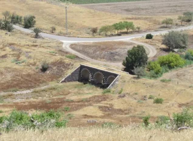


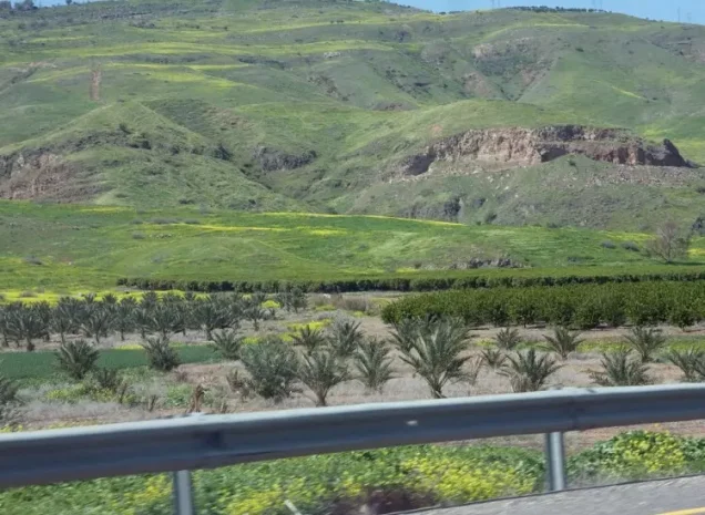


Photos from the village's people
Photos sent in by visitors and published after review.
Add a photo of this village
Log in to add photos of this village.
Other villages from Baysan
More from the archive



 Download Our Palestine App
The whole archive in the palm of your hand: depopulated villages, the Nakba, the massacres and Al-Aqsa — free, with no ads to erase the story.
Download Our Palestine App
The whole archive in the palm of your hand: depopulated villages, the Nakba, the massacres and Al-Aqsa — free, with no ads to erase the story.



Comments
No comments yet — be the first to write one.
Add your comment
Name and email are optional. Comments appear after review.