
The depopulated village of Sirin / District of Baysan
About the depopulated village of Sirin
- District
- Baysan
- Date Sirin was occupied
- 12 May 1948
- Population in 1948
- 940
- Military operation
- Operation Gideon
- Brigade that carried it out
- Golani Brigade
- Distance from the governorate centre
- 17 (km) North of Baysan
- Elevation above sea level
- 200 m
- Cause of displacement
- Abandonment based on Arab orders
- Extent of destruction
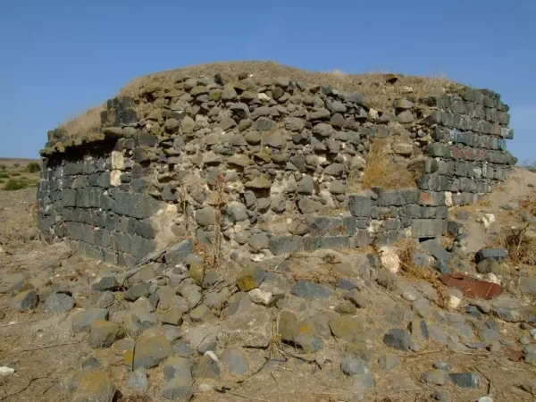
- Sirin was completely destroyed, and only its cemetery and one of its houses remain standing.
- Ethnic cleansing
- Sirin inhabitants were completely ethnically cleansed.
Hover a dot to read the village name, or click to open its card.
Borders of the depopulated village of Sirin
Sirin: A Depopulated Palestinian Village in the Baysan District
Sirin was a Palestinian village in the Baysan District, located in the far north of the district about 17 kilometres from the city of Baysan, at an average elevation of approximately 200 metres above sea level. Its lands covered 28,445 dunams. Units of the Zionist Golani Brigade occupied the village on 12 May 1948, and its inhabitants were displaced during the Nakba and the occupation of Palestine in 1948.
- Subdistrict
- Baysan
- Distance from district center
- 17 km North of Baysan
- Average Elevation
- 200 meters above sea level
- Population in 1931
- 630 inhabitants - Official census
- Number of Houses in 1931
- 161 houses - Official census
- Population in 1944/1945
- 810 inhabitants - Government of Palestine statistics: 620 Muslims and 190 Christians
- Estimated Population in 1948
- About 940 inhabitants - a later demographic estimate, not an official census
- Total Land Area in 1945
- 28,445 dunams
- Attack and Depopulation
- Sirin entered the decisive phase of the Nakba in May 1948, as units of the Golani Brigade advanced through the Baysan region and Lower Galilee.
- Final Israeli Control
- 12 May 1948
- Military Operation
- Gideon
- Military Unit
- Golani Brigade
- Cause of Depopulation
- Abandonment based on Arab orders
- Settlements Documented on Village Lands
- The reviewed sources record no Israeli settlements on the village lands
Location and Name
Sirin stood on a relatively level area of land that sloped gradually toward the southwest. Wadi al-Raduh bordered the village site to the northwest, while Wadi al-Bayadir lay to the southeast.
A secondary road connected the village with the main road leading north toward Samakh and south toward Baysan. Other secondary roads and paths linked Sirin with neighbouring Palestinian villages.
Palestine Remembered gives an interpretation of the name Sirin that connects it with the Aramaic word “sir,” meaning “summit.” PalQuest, however, does not present this derivation as an established explanation of the village name. It is therefore more appropriate to regard it as a traditional interpretation rather than a confirmed linguistic fact.
The Crusaders referred to the village as “Losserin.”
Sirin Through History
In 1596, Sirin was a village in the Jenin subdistrict of the Lajjun district. Sources used by Walid Khalidi record a population of 22 at that time. The inhabitants paid taxes on wheat, barley, goats, beehives, and other products.
In the early nineteenth century, British traveller James Silk Buckingham described Sirin as a village consisting of approximately thirty to forty houses, with around six Bedouin tents nearby.
By the late nineteenth century, the village was surrounded by cactus hedges and had an estimated population of about 100. Its houses were initially clustered around the junction of roads leading to neighbouring villages, but as Sirin expanded, new construction extended toward the northwest and southeast.
Population
The population of Sirin was 581 in the 1922 census and increased to 630 in the 1931 census, when 161 houses were recorded.
In the 1944/1945 Village Statistics, the population stood at 810, including 620 Muslims and 190 Christians.
The figure of approximately 940 inhabitants for 1948, reported by Palestine Remembered, is an estimate of the population shortly before displacement and not an official Government of Palestine census. The same applies to the estimate of 5,770 refugees and descendants in 1998.
Population of Sirin
- 159622Historical figure reported in the sources
- 1922581Official census
- 1931630Official census
- 1944/1945810Government of Palestine statistics: 620 Muslims and 190 Christians
- 1948About 940Estimate published by Palestine Remembered
- 19985,770Estimate of refugees and their descendants
Number of Houses
Documented and estimated number of houses in Sirin
- 1931161Official census
- 1948About 240Later estimate published by Palestine Remembered
Land of Sirin
According to the 1944/1945 statistics, the total land area of Sirin amounted to 28,445 dunams. Arabs owned 16,589 dunams, Jews owned 477 dunams, and 11,379 dunams were classified as public land.
Land ownership in Sirin in 1944/1945
- Arab ownership16,589 dunums58%
- Jewish ownership477 dunums2%
- Public land11,379 dunums40%
Agriculture and Land Use
Agriculture was the main foundation of Sirin's economy, and cereals and olives were among its principal crops. The village also had irrigated land and orchards.
According to the 1944/1945 statistics, a total of 15,813 dunams were devoted to cereals. This included 14,854 dunams of Arab-owned land, 471 dunams of Jewish-owned land, and 488 dunams of public land.
A further 413 dunams of Arab-owned land were irrigated or used for plantations, of which 109 dunams were planted with olive trees. The olive acreage formed part of the irrigated and plantation category and should not be added to it as a separate land-use category.
Land use in Sirin in 1944/1945, in dunams
- Arab
- Jewish
- Public
- Cereals15,813 dunums
- Irrigated and plantation land413 dunums
- Built-up area131 dunums
- Uncultivable land12,088 dunums
Education
Sirin had an elementary school for boys. The reviewed sources do not provide sufficiently documented information regarding the date of the school's establishment, the number of pupils, or the highest grade taught there, and no unverified details have therefore been added.
Archaeology in Sirin
Sirin and its surroundings contained several archaeological remains. A Greek inscription was discovered in the house of Zayd al-Shahada.
The sources also document remains from the Byzantine period, including a mosaic floor and a vaulted spring containing the remains of a decorated architectural element.
The frequently repeated reference to a “Cornice Castle” in the village has not been included because it does not correspond with the archaeological description provided by PalQuest and Walid Khalidi's All That Remains. It appears to have resulted from an inaccurate translation of the description of the architectural element associated with the spring.
The Nakba and the Occupation of Sirin
Sirin entered the decisive phase of the Nakba in May 1948, as units of the Golani Brigade advanced through the Baysan region and Lower Galilee.
Date of Occupation and Military Unit
Units of the Golani Brigade occupied Sirin on 12 May 1948, most likely in connection with the fall of the city of Baysan during the same period. In the same military advance, the villages of Ulam, Hadatha, and Ma'dhar also fell to Golani forces.
Operation Gideon
The occupation of Sirin occurred during the same period in which the Golani Brigade was carrying out Operation Gideon, between 10 and 15 May 1948. The operation was intended to seize control of the Baysan Valley and displace its Palestinian population.
Palestine Remembered directly associates the occupation of Sirin with Operation Gideon. The PalQuest page on Sirin confirms that Golani units occupied the village on 12 May but does not explicitly name the operation in the village entry itself. It is therefore more precise to state that Sirin was occupied in the context of the Golani offensive against Baysan and its surrounding area, coinciding with Operation Gideon, while noting this difference in the level of specificity between the sources.
Circumstances of the Population's Displacement
PalQuest reproduces an account from the History of the Haganah stating that the inhabitants of Sirin, Ulam, Hadatha, and Ma'dhar left their villages out of fear of the advancing Zionist forces. This account links the displacement directly to the military advance that ended with Golani forces taking control of the villages on 12 May.
PalQuest also reports a different account attributed to Israeli historian Benny Morris, who claimed that the inhabitants of the four villages had already left on 6 April 1948 on orders from the Arab Higher Committee. PalQuest itself describes this version as less credible.
Both accounts are mentioned here because they are reproduced by PalQuest, a Palestinian source used in this article, rather than through direct reliance on the Israeli sources in which they originally appeared. Because the accounts differ, the claim concerning orders from the Arab Higher Committee should not be presented as an established historical fact.
Fate of the Population and Buildings
The Palestinian inhabitants of Sirin were displaced during the Nakba, and most of the village buildings were destroyed after the occupation. The people of Sirin became refugees and displaced Palestinians away from their village.
Occupation and Depopulation Chronology
- May 1948
The Nakba and the Occupation of Sirin
Sirin entered the decisive phase of the Nakba in May 1948, as units of the Golani Brigade advanced through the Baysan region and Lower Galilee.
- 12 May 1948
Date of Occupation and Military Unit
Units of the Golani Brigade occupied Sirin on 12 May 1948, most likely in connection with the fall of the city of Baysan during the same period. In the same military advance, the villages of Ulam, Hadatha, and Ma'dhar also fell to Golani forces.
- 10 and 15 May 1948
Operation Gideon
The occupation of Sirin occurred during the same period in which the Golani Brigade was carrying out Operation Gideon, between 10 and 15 May 1948. The operation was intended to seize control of the Baysan Valley and displace its Palestinian population.
Israeli Settlements Established on the Lands of Sirin
Neither PalQuest nor Walid Khalidi's All That Remains records the establishment of an Israeli settlement on the lands of Sirin.
| Period | Settlements |
|---|---|
| Before 1948 | No documented settlements on the village lands |
| After 1948 | The reviewed sources record no Israeli settlements established on the village lands |
| According to PalQuest and All That Remains. | |
The Site of Sirin Today
According to the field documentation published by Walid Khalidi, only the cemetery and a single house, which was being used as a barn, remained from Sirin. Piles of stones surrounded by cactus plants were also visible at the site.
The village site was being used as a cattle enclosure, while a stone structure covered the spring located in the centre of the site. Some of the surrounding lands were cultivated with cotton.
This description reflects the period in which the original field documentation was conducted and should not necessarily be interpreted as a field survey of the site in 2026.
Sources
- PalQuest – Interactive Encyclopedia of the Palestine Question: Sirin.
- PalQuest: Operation Gideon.
- Palestine Remembered: Sirin, Baysan District.
- Walid Khalidi, All That Remains: Historical account of Sirin, reproduced by Palestine Remembered.
- Government of Palestine, Department of Statistics, Village Statistics, 1945, as reproduced in PalQuest and the Palestinian sources cited above.
- Walid Khalidi, All That Remains, entry on Sirin, as reproduced by PalQuest and Palestine Remembered.
```
Photo gallery


Photos from the village's people
Photos sent in by visitors and published after review.
Add a photo of this village
Log in to add photos of this village.
Other villages from Baysan

More from the archive



 Download Our Palestine App
The whole archive in the palm of your hand: depopulated villages, the Nakba, the massacres and Al-Aqsa — free, with no ads to erase the story.
Download Our Palestine App
The whole archive in the palm of your hand: depopulated villages, the Nakba, the massacres and Al-Aqsa — free, with no ads to erase the story.



Comments
No comments yet — be the first to write one.
Add your comment
Name and email are optional. Comments appear after review.