
The depopulated village of Al-Damun / District of Akka (Acre)
About the depopulated village of Al-Damun
- District
- Akka (Acre)
- Date Al-Damun was occupied
- 16 July 1948
- Population in 1948
- 1,520
- Military operation
- Operation Dekel
- Brigade that carried it out
- The Seventh Brigade
- Distance from the governorate centre
- 11.5 km southeast of Acre
- Elevation above sea level
- 35 m
- Cause of displacement
- Direct military assault by Israeli occupation forces, preceded by bombardment of the village, followed by the expulsion of the remaining inhabitants
- Extent of destruction
- The village was completely destroyed soon after occupation, and only house rubble left behind.
- Ethnic cleansing
- al-Damun inhabitants were completely ethnically cleansed.
- Settlements built on the built-up area of Al-Damun after 1948
- No Israeli settlements on village land, according to Khalidi; however, the settlement of Yas'ur, established in January 1949 on the lands of neighbouring al-Birwa, uses al-Damun's lands for agriculture
Hover a dot to read the village name, or click to open its card.
Borders of the depopulated village of Al-Damun
al-Damun: A Depopulated Palestinian Village in the Acre District
al-Damun was a Palestinian village in the Acre District, situated across the top and slopes of a rocky hill on the eastern edge of the Acre Plain, approximately 11.5 kilometres southeast of Acre and at an average elevation of about 35 metres above sea level. Its population reached 1,310 in the 1944/1945 statistics, including 1,240 Muslims and 70 Christians. Units of the Seventh, or Sheva', Brigade occupied the village on 15–16 July 1948 during the second stage of Operation Dekel. Its inhabitants were displaced and the village was destroyed during the Nakba and the occupation of Palestine in 1948.
- Subdistrict
- Acre
- Distance from district center
- 11.5 km southeast of Acre
- Average Elevation
- 35 m above sea level
- Population in 1931
- 917
- Number of Houses in 1931
- 183
- Population in 1944/1945
- 1,310 – 1,240 Muslims and 70 Christians
- Estimated Population in 1948
- About 1,520 – a later demographic estimate, not an official census
- Total Land Area in 1945
- 20,357 dunams
- Attack and Depopulation
- The village fell in the second stage of Operation Dekel on 15–16 July 1948 to units of the Seventh (Sheva') Brigade, according to Benny Morris as cited by Khalidi, whereas Palestinian historian Aref al-Aref dates its capture to late May 1948, following the fall of Acre. Some inhabitants fled during the bombardment that preceded the attack on the village; the rest were expelled, and the village was completely destroyed, according to both al-Aref and Morris.
- Final Israeli Control
- 15–16 July 1948, according to Benny Morris as cited by Khalidi; sources differ, as Aref al-Aref dates the village's fall to late May 1948, following the fall of Acre
- Military Operation
- Operation Dekel (second stage)
- Military Unit
- Units of the Seventh (Sheva') Brigade
- Cause of Depopulation
- Direct military assault by Israeli occupation forces, preceded by bombardment of the village, followed by the expulsion of the remaining inhabitants
- Settlements Documented on Village Lands
- No Israeli settlements on village land, according to Khalidi; however, the settlement of Yas'ur, established in January 1949 on the lands of neighbouring al-Birwa, uses al-Damun's lands for agriculture
Location
al-Damun stood on the eastern edge of the Acre Plain, spreading across the top and slopes of a rocky hill approximately 11.5 kilometres southeast of Acre.
Its average elevation was about 35 metres above sea level.
Secondary roads connected the village with the Acre–Safad and Acre–Haifa highways.
Its lands bordered or lay near those of al-Birwa, Sha'b, Kabul, Tamra, al-Ruways, and Shafa 'Amr.
al-Damun Through History
The inhabitants of al-Damun traced their origins to the al-Zaydaniyya tribe, which had migrated from the Hijaz.
The Persian Muslim traveller Nasir Khusraw recorded visiting al-Damun in 1047 after arriving from al-Birwa and mentioned visiting the shrine of Dhu al-Kifl.
Crusader sources referred to the village by a name rendered as Damar.
During the nineteenth century, al-Damun was surrounded by olive groves, and its population was estimated at approximately 800 in 1859.
Nineteenth-century descriptions also recorded two small mosques in the village.
Architecture
At the beginning of the twentieth century, al-Damun's houses were concentrated mainly along a single road.
From 1935 onward, villagers increasingly used reinforced concrete in house construction alongside traditional building materials.
The built-up area covered approximately 111 dunams in the 1944/1945 statistics.
Population
The 1922 census recorded 727 inhabitants in al-Damun: 687 Muslims and 40 Christians. The Christian inhabitants recorded in that census were Roman Catholics.
By the 1931 census, the population had increased to 917, including 870 Muslims and 47 Christians, living in 183 houses.
According to the 1944/1945 statistics, the population reached 1,310: 1,240 Muslims and 70 Christians.
The estimate of approximately 1,520 inhabitants in 1948 is a later demographic estimate rather than an official Mandate census figure.
Palestine Remembered estimates the number of refugees and their descendants at approximately 9,332 in 1998.
Population of al-Damun
- 1859About 800Historical estimate
- 1922727687 Muslims and 40 Christians
- 1931917870 Muslims and 47 Christians
- 1944/19451,3101,240 Muslims and 70 Christians
- 1948About 1,520Later estimate
- 19989,332Estimate of refugees and their descendants
Number of Houses
The 1931 census recorded 183 houses in al-Damun.
The figure of approximately 303 houses for 1948 is a later estimate rather than an official census count.
Education
Elementary education existed in al-Damun from the Ottoman period, with a school established in 1886.
Educational documents from the Mandate period confirm that the al-Damun school continued to operate and that teachers were appointed there during the 1930s and 1940s.
Local Palestinian documentation states that by 1948 the village had two elementary schools, with the older boys' school dating to 1886 and a second school established in the western part of the village during the British Mandate.
Because Walid Khalidi explicitly documents only one elementary school, the two-school description and details of the western school are presented here as additional local Palestinian documentation.
Water and Economic Life
The inhabitants obtained drinking water from nearby springs and irrigated some of their crops from the Na'amin River.
Agriculture formed the basis of the village economy. Wheat, sorghum, and barley were among the principal cereal crops, while olives were an important tree crop.
al-Damun was also known for its watermelons and cantaloupes.
Villagers engaged in supplementary crafts, particularly weaving mats and baskets from grasses and reeds growing near the river.
Land Ownership
According to the 1944/1945 statistics, al-Damun had a total land area of 20,357 dunams.
Arab ownership amounted to 19,073 dunams, Jewish ownership to 687 dunams, while 597 dunams were classified as public land.
Land Ownership in al-Damun in 1944/1945
- Arab ownership19,073 dunums94%
- Jewish ownership687 dunums3%
- Public land597 dunums3%
Land Use
Cereal cultivation covered 17,052 dunams: 16,256 Arab-owned dunams, 684 Jewish-owned dunams, and 112 dunams of public land.
Irrigated and plantation land covered 709 dunams: 706 Arab-owned and 3 Jewish-owned.
Approximately 484 dunams of Arab agricultural land were planted with olive trees. This represents a crop category within cultivated land and should not be added separately to the overall land-use total.
The built-up area covered 111 Arab-owned dunams.
Uncultivable land covered 2,485 dunams: 2,000 Arab-owned dunams and 485 dunams of public land.
Land Use in al-Damun in 1944/1945, in Dunams
- Arab
- Jewish
- Public
- Irrigated and plantation land709 dunums
- Cereals17,052 dunums
- Built-up area111 dunums
- Uncultivable land2,485 dunums
Mosques, Church, and Shrines
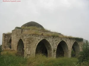
Historical sources recorded two small mosques in al-Damun during the nineteenth century, while Walid Khalidi later referred to the village's well-known mosque.
Local Palestinian documentation also records a church in the eastern quarter of the village, together with a central mosque and other religious sites.
Local accounts describe the central mosque as an old stone structure with a courtyard and well and date its construction to 1722–1723. Because this date is based primarily on local documentation, it is not presented as independently established by the principal reference source.
Village traditions also record several shrines and tombs, including Dhu al-Kifl, Abd al-Mughith, Ahmad al-Ajami, Shaykh Abdallah al-Dajani, Banat al-Zawiya, and Shaykh Muhammad.
The shrine of Dhu al-Kifl is the best attested of these in the historical literature, having been mentioned by Nasir Khusraw during his eleventh-century visit.
Archaeological Remains
An archaeological tell west of the village contained the foundations of walls, fortifications, and a well.
Local Palestinian documentation also records caves, burial areas, and other archaeological features around al-Damun.
The precise identification of all these remains with particular historical periods requires specialist archaeological evidence, and this article therefore avoids unsupported chronological claims.
Operation Dekel
Operation Dekel began on 8 July 1948 and continued until 18 July.
The operation sought to expand Israeli control in western and Lower Galilee and involved forces primarily from the Seventh (Sheva') Brigade, Carmeli Brigade, and Golani Brigade.
During the initial stage, forces from the Seventh Brigade and the First Battalion of the Carmeli Brigade advanced along an axis in western Galilee.
In the second stage, units of the Seventh Brigade turned westward to occupy several villages in western Galilee, including al-Damun.
The Occupation and Depopulation of al-Damun
The detailed Operation Dekel account places the occupation of al-Damun on 15–16 July 1948 during the second stage of the operation.
The direct attacking force is identified as units of the Seventh, or Sheva', Brigade.
Palestine Remembered gives 15 July 1948 as the occupation date and likewise identifies the Seventh Brigade as the attacking formation.
The sources reviewed do not identify a specific battalion as the unit that directly entered al-Damun, and this article therefore does not assign the village's capture to a particular battalion.
Palestinian historian 'Arif al-'Arif gave an earlier date, placing the fall of al-Damun in late May 1948 after the fall of Acre.
This chronology is substantially earlier than the detailed Operation Dekel account. The article therefore treats 15–16 July as the stronger documented chronology while preserving al-'Arif's differing account.
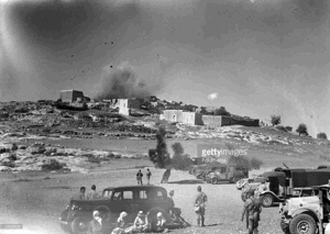
PalQuest and Walid Khalidi, transmitting Israeli-source material, report that some villagers fled during the bombardment preceding the assault, while the remaining inhabitants were expelled after the village was entered.
al-Damun was subsequently extensively destroyed.
Information originating in Israeli sources is cited here only as transmitted through Walid Khalidi and PalQuest, not through direct reliance on the original Israeli sources.
Occupation and Depopulation Chronology
- 8 July 1948
Beginning of the military operation
Operation Dekel began on the night of 8 July. After the initial Israeli successes in central Galilee during its first stage, units of the Seventh (Sheva') Brigade moved westwards to take control of a number of western Galilee villages, al-Damun among them.
- Just before the attack (15–16 July 1948, according to Morris)
Shelling of the village and beginning of the exodus
According to Morris as cited by Khalidi, the inhabitants had been demoralized by the fall of Acre and Nazareth, and some of them fled during the bombardment that preceded the attack on the village.
- 15–16 July 1948, or late May 1948 according to al-Aref
Final occupation
According to Morris as cited by Khalidi, the village fell in the second stage of Operation Dekel to units of the Seventh (Sheva') Brigade. Palestinian historian Aref al-Aref, however, dates its capture much earlier, to late May 1948, following the fall of Acre.
- After the occupation (the sources give no date)
Expulsion of the remaining inhabitants
The inhabitants who remained in the village were expelled, according to both al-Aref and Morris as cited by Khalidi.
- After the occupation (the sources give no date)
Destruction of the village
The village was completely destroyed, according to both al-Aref and Morris as cited by Khalidi.
Israeli Settlements and al-Damun's Lands
According to Walid Khalidi and PalQuest, no Israeli settlement was established directly on al-Damun's lands.
Yas'ur
Yas'ur was established in January 1949 on lands belonging to the neighbouring Palestinian village of al-Birwa, approximately 3 kilometres northwest of al-Damun.
Although it was not built on al-Damun's lands, Yas'ur used portions of the village lands, particularly those on the Acre Plain, for agriculture.
al-Damun After the Nakba
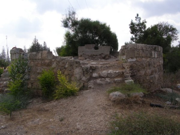
According to the field documentation relied upon by Walid Khalidi, much of the village site became overgrown with thorns, cactus plants, olive trees, and pine trees.
Stone and concrete rubble was scattered across the site.
The structure that had protected the principal spring and regulated its flow survived but was neglected and deteriorating in several places at the time of documentation.
The village cemetery also remained, although some grave markers were deteriorating.
Later Palestinian documentation records continued visits by displaced villagers and efforts to maintain parts of the cemetery.
The surrounding lands, particularly those on the Acre Plain, were used for agriculture.
Khalidi's description reflects the condition of the site during his field documentation and should not necessarily be treated as a comprehensive survey updated to 2026.
Sources
- PalQuest – Interactive Encyclopedia of the Palestine Question: al-Damun.
- PalQuest: Operation Dekel.
- Palestine Remembered: al-Damun, Acre District.
- Walid Khalidi, All That Remains, entry on al-Damun.
- 'Arif al-'Arif, writings on the Nakba and the villages of the Acre District.
- Local Palestinian documentation of al-Damun published through Palestine Remembered.
- Government of Palestine, censuses of 1922 and 1931.
- Government of Palestine, Department of Statistics, Village Statistics, 1945.
Photo gallery


Photos from the village's people
Photos sent in by visitors and published after review.
Add a photo of this village
Log in to add photos of this village.
Other villages from Akka (Acre)
More from the archive


 Download Our Palestine App
The whole archive in the palm of your hand: depopulated villages, the Nakba, the massacres and Al-Aqsa — free, with no ads to erase the story.
Download Our Palestine App
The whole archive in the palm of your hand: depopulated villages, the Nakba, the massacres and Al-Aqsa — free, with no ads to erase the story.



Comments
No comments yet — be the first to write one.
Add your comment
Name and email are optional. Comments appear after review.