
The depopulated village of 'Arab al-Samniyya / District of Akka (Acre)
'Arab al-Samniyya
About the depopulated village of 'Arab al-Samniyya
- District
- Akka (Acre)
- Date 'Arab al-Samniyya was occupied
- 30 October 1948
- Population in 1948
- 230
- Military operation
- Operation Hiram
- Brigade that carried it out
- The Seventh Brigade، Golani Brigade، The Carmeli Brigade
- Distance from the governorate centre
- 19.5 (km) Northeast of Acre
- Elevation above sea level
- 150 m
- Cause of displacement
- Military assault by Zionist troops
- Extent of destruction
- The village was completely destroyed, and only house rubble left behind.
- Ethnic cleansing
- 'Arab al-Samniyya inhabitants were completely ethnically cleansed.
Hover a dot to read the village name, or click to open its card.
Arab al-Samniyya / Khirbat al-Suwwana – Depopulated Palestinian Community of Acre
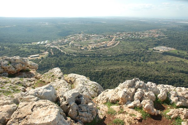
'Arab al-Samniyya was a depopulated Palestinian tribal community in the Acre Subdistrict, also identified by Walid Khalidi and PalQuest as Khirbat al-Suwwana. It stood on a rocky hill in western Upper Galilee, approximately 19.5 kilometers northeast of Acre and at an average elevation of about 150 meters above sea level.
The village lay near the road linking Ra's al-Naqura with Safad. A dirt track connected it with the coastal highway and from there with Acre. The wider territory associated with the Samniyya tribe extended through several localities between Wadi Karkara, Wadi al-Qarn, al-Bassa, Iqrit, Tarbikha, and the Palestine-Lebanon border region.
Palestinian local documentation also uses the name Jalin for one of the areas inhabited by branches of the Samniyya. Jalin should therefore be understood as part of the wider tribal residential and land landscape rather than simply treated as a fully interchangeable official name for the statistical village unit recorded by Khalidi and PalQuest.
Basic Information
| Field | Information |
|---|---|
| Principal name | 'Arab al-Samniyya |
| Documented alternative name | Khirbat al-Suwwana |
| Jalin | A locality within the broader Samniyya tribal landscape and a residence area of several tribal branches in Palestinian local documentation |
| Subdistrict | Acre |
| Distance from Acre | Approximately 19.5 km northeast |
| Average elevation | Approximately 150 m above sea level |
| Houses in 1931 | 13 |
| Population in 1944/45 | 200 – the official figure includes 'Arab al-Tawqiyya |
| Land area in 1944/45 | 1,872 dunums – also includes 'Arab al-Tawqiyya |
| Probable occupation date | 30–31 October 1948 |
| Military operation | Operation Hiram |
| Military unit | 'Oded Brigade – strongly suggested by the documented axis of advance; no more precise village-level unit is established |
| Cause of depopulation | Military occupation followed by flight and/or expulsion during the consolidation of Israeli control along the Lebanon border; the village may not have been emptied immediately |
| Post-1948 settlement | Ya'ara, established on village lands in 1950 |
'Arab al-Samniyya, Khirbat al-Suwwana, and Jalin
'Arab al-Samniyya was the name of the wider tribal community.
Khirbat al-Suwwana is the alternative village name used by Khalidi and PalQuest for the depopulated locality included in the standard village record.
Palestinian local documentation shows that the Samniyya were not confined to one settlement point. Families and tribal branches lived at al-Suwwana, Jalin, Huwara, Khirbat 'Iribbin, and other nearby locations.
Jalin is documented as an area of Samniyya land and as a residence of members of the Sarahina and 'Ata'ata branches. It is therefore important to the community's history but should not automatically be treated as an official statistical synonym for the entire village unit.
Location and Territorial Context
Khirbat al-Suwwana stood on a steep rocky hill near the road from Ra's al-Naqura to Safad.
A dirt road connected the community to the coastal highway and onward to Acre.
Palestinian local documentation describes the wider Samniyya tribal land area as extending between al-Bassa to the west, Iqrit and Tarbikha to the east, Wadi al-Qarn to the south, and Wadi Karkara and the Lebanon border area to the north.
These wider tribal boundaries should not be confused with the 1,872-dunum official statistical unit used in the 1945 village tables, since Samniyya families also owned land in additional khirbas and localities.
Population
| Year | Population | Note |
|---|---|---|
| 1931 | No independent population total is displayed by PalQuest | PalQuest records 13 houses; population is not inferred from the house count |
| 1944/45 | 200 | Official estimate for a statistical unit including 'Arab al-Samniyya and 'Arab al-Tawqiyya |
| 1948 | Approx. 230 | Later secondary estimate, not an official census; its 1945 base is itself aggregated with 'Arab al-Tawqiyya |
The figure of 200 should therefore not be described as an independently documented population total for Khirbat al-Suwwana alone.
Number of Houses
PalQuest records thirteen occupied houses for 1931.
No reliable official house count for 1948 has been established, and no figure is extrapolated from population estimates.
Land Ownership, 1944/45
The official figures below apply to the statistical unit that also included 'Arab al-Tawqiyya:
- Palestinian1,872 dunums100%
- Transferred to Zionists0 dunums0%
- Public0 dunums0%
The total balances exactly.
Palestinian local documentation separately gives approximately 120 dunums for Khirbat al-Suwwana itself and states that most of this land belonged to the Kallam and al-Hawshi families. This local cadastral figure concerns the Suwwana locality and should not be confused with the broader 1,872-dunum official statistical unit.
Land Use, 1944/45
The following figures likewise apply to the combined statistical unit including 'Arab al-Tawqiyya:
- Cereals174 dunums9%
- Plantations and irrigable land22 dunums1%
- Non-cultivable land as presented in the published table1,676 dunums90%
The figures balance exactly: 174 + 22 + 1,676 = 1,872 dunums.
PalQuest does not provide a separate built-up-area figure for this statistical unit, so no unsupported value is introduced.
Economy
Khalidi specifically records cereals, figs, and olives among the crops cultivated by the villagers.
Palestinian local history adds livestock raising, grapes, apples, and tobacco production to the economic profile of the Samniyya.
Community accounts state that tobacco was marketed to companies in Haifa and that some families also produced charcoal and sold milk and dairy products.
These additional details derive from Palestinian local and tribal documentation, while cereals, figs, and olives are directly recorded in Khalidi's village account.
Tribal Branches and Families
Palestinian community documentation divides the Samniyya into four principal branches: al-Sarahina, al-'Ata'ata, al-Quray'at, and al-Manasira.
The Sarahina lived in Jalin, al-Suwwana, and Huwara, while the 'Ata'ata were particularly associated with Jalin. Other branches lived near Mi'ilya, Ma'sub, and al-Suwwana.
Family names preserved in local documentation include Kallam, Fa'ur, 'Aqla, Jum'a, al-Mahmud, Jaddu', Thalji, al-Hawshi, and others.
These are community-history records and should not be treated as official census categories.
Cemeteries and Burial Places
Palestinian local documentation records Samniyya burial places in al-Suwwana, Khirbat Samah, Ard al-Hawta, and other parts of the tribal landscape.
Oral history also records a cemetery at Khirbat Jalin where members of the community were buried before the Nakba.
Khalidi's concise village account does not independently document a mosque or named shrine for 'Arab al-Samniyya, so no religious building is asserted without stronger evidence.
Education and Services
No independently documented school specific to 'Arab al-Samniyya was located in the principal sources reviewed.
No pupil or teacher figures are therefore supplied.
Operation Hiram
Operation Hiram began on 28 October 1948 and ended on 31 October.
The operation targeted the remaining Arab-held area of Upper Galilee after the second truce.
At the operational level, the Seventh, Carmeli, Golani, and 'Oded brigades participated along separate axes.
Their participation in the overall offensive should not be interpreted to mean that every brigade directly attacked 'Arab al-Samniyya.
Occupation of 'Arab al-Samniyya – 30–31 October 1948
Khalidi and PalQuest consider it probable that 'Arab al-Samniyya was occupied at the end of Operation Hiram, on 30–31 October 1948.
After capturing large sections of Upper Galilee, participating forces were ordered to extend their control along the Palestine-Lebanon border.
During this phase the 'Oded Brigade advanced westward toward the coast along the road parallel to the border and captured Iqrit and Tarbikha on 31 October.
Because 'Arab al-Samniyya lay along this axis, PalQuest considers it probable that the village was occupied during the same advance or shortly after neighboring Iqrit and Tarbikha were reached.
Military Unit
The Seventh, Carmeli, Golani, and 'Oded brigades all participated in Operation Hiram.
For 'Arab al-Samniyya specifically, however, the 'Oded Brigade is the strongest village-level attribution available because Khalidi and PalQuest directly connect the probable occupation of the village to its westward advance along the border road.
No specific battalion or company is independently documented as the unit that entered the village.
Depopulation
Khalidi does not establish that 'Arab al-Samniyya was emptied immediately when Israeli forces reached it on 30–31 October.
As with nearby Iqrit and Tarbikha, some residents may have remained after the fighting had ended.
Circumstantial evidence cited in Khalidi's account suggests that the remaining population may have been expelled during the following weeks as Israeli forces sought to consolidate a depopulated border strip.
The date of military occupation should therefore be distinguished from the completion of the community's displacement.
Palestinian Local Accounts of Displacement
Samniyya oral history records movement between several localities during the fighting, followed by the gathering of some community members around Shi'hin near the border in late October 1948.
Many later moved into Lebanon, while others settled in Syria and Jordan. A portion of the wider Samniyya community remained inside Palestine, including families in Shafa 'Amr, 'Ibillin, al-Mazra'a, Shaykh Dannun, and Tarshiha.
These details are preserved through Palestinian family and community history and complement, rather than replace, Khalidi's military chronology.
Cause of Depopulation
The displacement of 'Arab al-Samniyya was tied to Operation Hiram and the final military conquest of the Palestine-Lebanon border region in late October 1948.
The evidence does not establish that the entire population fled under fire at the moment of occupation. Some residents may have remained for a short period before being expelled.
The most accurate formulation is therefore: military occupation at the end of Operation Hiram, followed by flight and expulsion as control over the border zone was consolidated.
Destruction
The built environment of 'Arab al-Samniyya / Khirbat al-Suwwana was extensively destroyed after the population was displaced.
Khalidi does not provide a precise date for the demolition of the village buildings, so destruction should not automatically be assigned to 30 or 31 October.
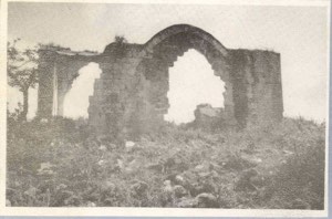
Later fieldwork recorded stone house rubble, crumbling walls, and portions of surviving roofs.
Ethnic Cleansing in Source Classification
Some Palestinian sources classify the displacement of 'Arab al-Samniyya using the term “ethnic cleansing.” The term is retained only as an attributed source classification.
The more specifically documented facts are the military occupation of the border region during Operation Hiram, the possible continued presence of some villagers after the fighting, their subsequent displacement or expulsion, and the absence of a permanent collective return to the village site.
Occupation Chronology
| Date | Event |
|---|---|
| 28 October 1948 | Operation Hiram begins in Upper Galilee. |
| 29–30 October 1948 | The offensive expands and numerous Palestinian villages in Upper Galilee come under Israeli military control. |
| 30 October 1948 | The eastern and western axes of Operation Hiram converge around Sa'sa', bringing the offensive closer to the area east of 'Arab al-Samniyya. |
| 30–31 October 1948 | The 'Oded Brigade advances westward toward the coast along the border road; 'Arab al-Samniyya was probably occupied during this phase. |
| 31 October 1948 | The 'Oded Brigade captures nearby Iqrit and Tarbikha as Operation Hiram ends. |
| Following weeks | Residents who may have remained in 'Arab al-Samniyya were likely displaced as the border zone was cleared and consolidated. |
| 1950 | Ya'ara is established on village lands. |
Israeli Settlements on 'Arab al-Samniyya's Lands
According to Walid Khalidi and PalQuest, Ya'ara was established on the village lands in 1950.
Palestinian local documentation also identifies later settlements and installations on parcels owned by Samniyya families in Huwara, Tall al-Hawa, Khirbat 'Iribbin, and other parts of the wider tribal territory.
Those broader family landholdings should not automatically be treated as part of the same 1,872-dunum statistical unit recorded for 'Arab al-Samniyya / Khirbat al-Suwwana in 1945.
Ya'ara is therefore the settlement listed here as directly and independently documented on the village lands.
'Arab al-Samniyya Today
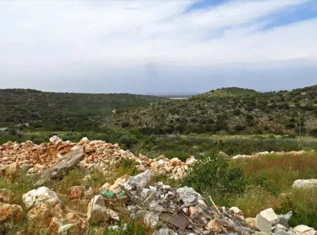
According to the field description used by Walid Khalidi before the publication of All That Remains in 1992, only stone rubble, crumbling walls, and portions of roofs remained from the village buildings.
The terraces of the former fig and olive groves were still visible in the landscape.
Later Palestinian community documentation preserves additional information about Jalin, al-Suwwana, Huwara, Khirbat 'Iribbin, and other localities associated with the Samniyya tribe. Such material is valuable community documentation rather than a comprehensive archaeological or cadastral survey.
Khalidi's description represents historical fieldwork conducted before 1992 and should not be treated as a comprehensive direct survey of the site in 2026.
Sources
- PalQuest – Interactive Encyclopedia of the Palestine Question: 'Arab al-Samniyya
- PalQuest – Operation Hiram
- Palestine Remembered – 'Arab al-Samniyya, Acre Subdistrict
- Palestine Remembered – 'Arab al-Samniyya entry from Walid Khalidi's All That Remains
- Palestinian Villages Encyclopedia – 'Arab al-Samniyya / Jalin
- Palestinian Villages Encyclopedia – Khirbat al-Suwwana / 'Arab al-Samniyya
- Palestine Remembered – Palestinian community history of the Samniyya tribe
- Palestine Remembered – Important localities within the wider Samniyya tribal lands
Photo gallery
Photos from the village's people
Photos sent in by visitors and published after review.
Add a photo of this village
Log in to add photos of this village.
Other villages from Akka (Acre)


More from the archive

 Download Our Palestine App
The whole archive in the palm of your hand: depopulated villages, the Nakba, the massacres and Al-Aqsa — free, with no ads to erase the story.
Download Our Palestine App
The whole archive in the palm of your hand: depopulated villages, the Nakba, the massacres and Al-Aqsa — free, with no ads to erase the story.



Comments
No comments yet — be the first to write one.
Add your comment
Name and email are optional. Comments appear after review.