
The depopulated village of Suruh / District of Akka (Acre)
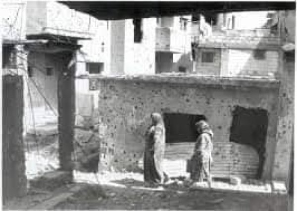
About the depopulated village of Suruh
- District
- Akka (Acre)
- Date Suruh was occupied
- 31 October 1948
- Population in 1948
- 90
- Military operation
- Operation Hiram
- Distance from the governorate centre
- 28.5 (km) Northeast of Acre
- Elevation above sea level
- 525 m
- Cause of displacement
- Expulsion by Zionist troops
- Extent of destruction
- Suruh was completely destroyed, and only house rubble left behind.
- Ethnic cleansing
- Suruh inhabitants were completely ethnically cleansed.
- Settlements built on the built-up area of Suruh after 1948
- Shtula
Hover a dot to read the village name, or click to open its card.
Borders of the depopulated village of Suruh
Suruh – Depopulated Palestinian Village in Acre Subdistrict
Suruh, also rendered in Arabic as Suruh or Surouh, was a small Palestinian village in the Acre subdistrict of Upper Galilee. It stood approximately 28.5 kilometers northeast of Acre, close to the Lebanese frontier, at an average elevation of about 525 meters above sea level.
The village occupied a rocky hill overlooking Tarbikha and faced the neighboring hamlet of al-Nabi Rubin. Both Suruh and al-Nabi Rubin were satellite communities of Tarbikha and relied on the larger village for services and education.
Suruh's demographic and land statistics require particular caution. The official 1944/45 statistics grouped Tarbikha, Suruh, and al-Nabi Rubin into one statistical unit with a combined population of 1,000 and 18,563 dunums of land. These figures should not be presented as if they belonged to Suruh alone.
The village's depopulation must also be distinguished from Operation Hiram itself. Hiram formally ended on 31 October 1948, while Walid Khalidi places the expulsion of Suruh's inhabitants in the second week of November, during the subsequent campaign to empty Palestinian villages along the Lebanese frontier.
Key Facts about Suruh
| Field | Information |
|---|---|
| Name | Suruh |
| Arabic variant | سروح / صروح |
| Subdistrict | Acre |
| Distance from Acre | Approximately 28.5 km northeast |
| Average elevation | Approximately 525 m above sea level |
| Local status | Satellite village/hamlet of Tarbikha, like al-Nabi Rubin |
| Late nineteenth-century population | Approximately 90, mostly Muslims – historical estimate |
| Population, 1931 | No independent figure available |
| Population, 1944/45 | 1,000 for Tarbikha + Suruh + al-Nabi Rubin combined, not Suruh alone |
| Land area, 1944/45 | 18,563 dunums for the same combined statistical unit |
| Depopulation date | Second week of November 1948 |
| Military context | Post-Hiram clearing of Palestinian villages along the Lebanese frontier |
| Military unit | Not independently identified for Suruh; the Oded Brigade is documented at neighboring Tarbikha during the same campaign |
| Cause of depopulation | Military expulsion during the northern border-clearing campaign |
| Extent of destruction | The village was almost entirely destroyed; rubble and vegetation remained |
| Settlements on village land | Shomera partly on the site; Kefar Rosenwald/Zar'it and Shetula on village lands |
Name
PalQuest uses the Arabic form Suruh, while other Palestinian sources also render the name with the Arabic spelling صروح.
Khalidi does not provide a definitive historical etymology, so no speculative derivation has been adopted as a proven origin of the name.
Suruh and the 1923 Border
Suruh had an unusual frontier history, like a number of communities in Upper Galilee near Lebanon.
The locality had been under French administration after World War I. The final Franco-British boundary settlement of 1923 incorporated Suruh and a number of other frontier villages into Mandatory Palestine.
Tarbikha, to which Suruh was attached locally, likewise entered Palestinian administration after the frontier was redrawn.
For this reason, no 1922 British-Palestinian census figure has been inserted for Suruh as though the village had been an ordinary independent unit within the Palestine census area at that time.
Location
Suruh stood on a rocky hill in Upper Galilee near the Lebanese frontier.
It overlooked Tarbikha to the west and faced the neighboring hamlet of al-Nabi Rubin.
Tarbikha was approximately one kilometer away and supplied both smaller communities with important services.
Local Palestinian geographical descriptions place Lebanon to the north and northeast, Tarbikha to the west, al-Nabi Rubin to the south, and al-Mansura to the southeast.
Suruh in the Nineteenth Century
The Survey of Western Palestine described Suruh in the late nineteenth century as a small agricultural village.
Its population was estimated at approximately 90, most of them Muslims.
The houses were built of stone, and the inhabitants relied on agriculture and livestock raising.
They cultivated cereals, olives, grapes, tobacco, and other crops.
Population
Suruh does not have the same independent census sequence available for many larger Palestinian villages.
| Year | Population | Notes |
|---|---|---|
| Late nineteenth century | Approximately 90 | Historical Survey estimate, not an official Mandate census |
| 1922 | Not used | The locality was affected by the frontier settlement and was not treated here as an ordinary independent Palestine census unit |
| 1931 | Not independently available | Khalidi records the figure as unavailable |
| 1944/45 | 1,000 | Combined total for Tarbikha, Suruh, and al-Nabi Rubin, not Suruh alone |
Correcting the 1,000 Population Figure
The figure of 1,000 often appears on webpages under Suruh's name and can easily be misread as the village's own 1945 population.
The original statistical unit, however, was Tarbikha including Suruh and al-Nabi Rubin.
The 1,000 inhabitants therefore represent the three communities combined, and the published table does not provide a reliable method for separating Suruh's population from the total.
Number of Houses
No independent 1931 house count is documented for Suruh.
The figure of 149 houses belongs to Tarbikha in the 1931 census and should not be transferred to Suruh.
Khalidi likewise provides no separate house estimate for Suruh immediately before the Nakba.
Land Ownership in 1944/45
Tarbikha, Suruh, and al-Nabi Rubin were combined into a single statistical unit in the official 1944/45 records.
The following table therefore applies to the three communities together:
- Arab / Palestinian12,548 dunums68%
- Jewish / Transferred to Zionists0 dunums0%
- Public / Communal6,015 dunums32%
The figures balance exactly: 12,548 + 6,015 = 18,563 dunums.
The total should not be described as the independent land area of Suruh.
Land Use in 1944/45
The same qualification applies to land use because the official figures cover all three communities.
- Arab
- Public
- Cereals3,204 dunums
- Plantations and irrigable land619 dunums
- Built-up land112 dunums
- Non-cultivable land14,628 dunums
The land-use figures balance exactly:
3,204 + 619 + 112 + 14,628 = 18,563 dunums.
The official table does not allow these acreages to be reliably divided among Tarbikha, Suruh, and al-Nabi Rubin.
Economic Life
Suruh was a small agricultural and pastoral community.
Residents cultivated grain, olives, grapes, tobacco, and other crops while also raising livestock.
The pattern reflects the mixed agricultural and grazing economy common in the mountainous frontier region of Upper Galilee.
The 1944/45 cereal and orchard acreages, however, are combined figures for the three communities and should not be assigned to Suruh alone.
Education and Services
No independent school is documented in Suruh.
Village children attended the elementary school in Tarbikha, approximately one kilometer away.
Tarbikha's school was founded after 1938 and enrolled approximately 120 pupils in the mid-1940s, including children from Suruh and al-Nabi Rubin.
Suruh's inhabitants also relied on Tarbikha for other basic services.
Water Resources
Khalidi's Suruh entry does not provide a separate list of village water sources.
The broader Tarbikha–Suruh area contained springs, reservoirs, and wells, while Tarbikha provided important services to its two satellite communities.
Ancient cisterns or wells also existed at the khirbas near Suruh.
Archaeological Remains
Two khirbas near Suruh contained a variety of older remains.
These included ruined walls, wells or cisterns, and rock-cut tombs.
The remains demonstrate earlier occupation in the area, although Khalidi does not assign all of them to a single securely identified archaeological period.
Operation Hiram and the Military Context
Operation Hiram began on 28 October 1948 and ended on 31 October.
Israeli forces occupied most of Upper Galilee during the offensive. At the campaign level, the Sheva', Carmeli, Golani, and Oded brigades were among the principal participating formations.
At the end of Hiram, orders were issued to expand Israeli control along the Lebanese frontier.
A subsequent phase therefore followed the formal operation, targeting frontier villages whose Palestinian inhabitants had remained in place.
Depopulation of Suruh
According to Walid Khalidi, the inhabitants of Suruh were among the first villagers expelled during the Israeli campaign to clear the northern frontier with Lebanon.
Khalidi places this event in the second week of November 1948, after Operation Hiram had formally ended.
Israeli forces moved rapidly into a number of remaining frontier villages and removed their inhabitants.
The account Khalidi cites does not establish whether Suruh's inhabitants were forced directly across the Lebanese border, as occurred in many neighboring villages, or whether they were first transported by truck to another location inside Israeli-held territory.
For several weeks afterward Israeli forces carried out periodic raids on frontier villages to prevent displaced inhabitants from returning to their homes.
Correcting the 31 October / 1 November Date
Some databases give 31 October or 1 November 1948 as Suruh's occupation or depopulation date and associate it directly with Operation Hiram.
Khalidi, however, places the villagers' expulsion in the second week of November, whereas Operation Hiram ended on 31 October.
The chronology should therefore distinguish:
- the end of Operation Hiram and the military occupation of most of Upper Galilee on 30–31 October;
- the subsequent border-clearing campaign in early and mid-November;
- the expulsion of Suruh's inhabitants in the second week of November 1948.
Military Unit
Khalidi's Suruh entry does not identify the specific unit that entered and evacuated the village.
At neighboring Tarbikha, of which Suruh was a satellite, Khalidi explicitly states that the Oded Brigade entered during the second week of November and ordered the inhabitants to cross into Lebanon.
The two communities were affected by the same broader frontier-clearing campaign.
This contextual connection, however, is not sufficient to present the Oded Brigade as a definitively documented Suruh-specific unit without a direct village-level source.
Cause of Depopulation
The documented cause of Suruh's depopulation was military expulsion during the campaign to empty the northern frontier villages.
Khalidi's account does not portray the villagers as simply fleeing an ongoing battle: the major fighting had subsided, and Israeli forces subsequently advanced into the border villages and removed their inhabitants.
The exact route taken by Suruh's expelled population remains uncertain.
Ethnic Cleansing
Palestine Remembered characterizes the final outcome at Suruh as complete ethnic cleansing.
Khalidi directly documents the expulsion of Suruh's population during the frontier-clearing campaign and the subsequent military raids intended to prevent displaced villagers from returning.
The term “ethnic cleansing” is therefore retained as an attributed characterization used by Palestine Remembered, while the directly documented descriptive facts are the complete expulsion of Suruh's Palestinian community and the prevention of its return.
Occupation and Depopulation Chronology
- 28 October 1948
Beginning of Operation Hiram
The large-scale offensive against the remaining Arab-held areas of Upper Galilee began.
- 30–31 October 1948
Advance to the frontier
Israeli forces gained control of most of Upper Galilee and reached wide stretches of the Lebanese frontier.
- 31 October 1948
End of Operation Hiram
The formal operation ended, followed by orders to consolidate control along the border.
- Early November 1948
Beginning of border clearances
Forces moved into frontier villages whose populations remained and ordered evacuations for military reasons.
- Second week of November 1948
Depopulation of Suruh
The inhabitants were expelled; Khalidi's source does not determine whether they were sent directly to Lebanon or first transported elsewhere.
- Following weeks
Prevention of return
Periodic military raids were carried out in the border villages to prevent displaced residents from returning.
- Precise date not documented
Destruction
Most of the village disappeared, leaving rubble and vegetation in Khalidi's later field survey.
Israeli Settlements on Suruh's Lands
| Settlement | Established | Relationship to Suruh |
|---|---|---|
| Shomera | 1949 | Established on part of the Suruh village site; it is also associated with neighboring Tarbikha's site and lands |
| Even Menachem | 1960 | Located very close to the village site; PalQuest does not identify it as established directly on Suruh's lands |
| Kefar Rosenwald / Zar'it | 1967 | Established on village land |
| Shetula | 1969 | Established on village land |
Some secondary sources contain errors in this settlement list, including dating Even Menachem to 1967 or treating it as established directly on Suruh's land. Khalidi/PalQuest date Even Menachem to 1960 and describe it as very close to the site, while explicitly placing Kefar Rosenwald and Shetula on Suruh's lands.
Suruh Today
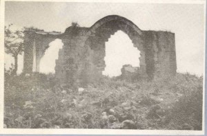
According to Walid Khalidi's field description, only rubble, trees, cactus plants, grass, and wild vegetation remained visible at the former village site.
Most of the site had become grazing land.
The stone-built residential nucleus described in nineteenth-century surveys had disappeared, and Khalidi did not record intact village houses surviving at the site.
This description derives from fieldwork undertaken before the publication of All That Remains in 1992 and should therefore be treated as documented historical site evidence rather than comprehensive direct field verification of conditions in 2026.
Sources
- PalQuest – Interactive Encyclopedia of the Palestine Question: Suruh
- PalQuest – Tarbikha, for the combined statistical unit and border-clearance chronology
- PalQuest – al-Nabi Rubin, for the combined statistics and November 1948 frontier expulsions
- PalQuest – Operation Hiram
- Palestine Remembered – Suruh, Acre District
- Walid Khalidi – All That Remains: Suruh
- Palestinian Encyclopedia – Tarbikha, Suruh, and al-Nabi Rubin
- Institute for Palestine Studies – All That Remains, Walid Khalidi
Photos from the village's people
Photos sent in by visitors and published after review.
Add a photo of this village
Log in to add photos of this village.
Other villages from Akka (Acre)

More from the archive


 Download Our Palestine App
The whole archive in the palm of your hand: depopulated villages, the Nakba, the massacres and Al-Aqsa — free, with no ads to erase the story.
Download Our Palestine App
The whole archive in the palm of your hand: depopulated villages, the Nakba, the massacres and Al-Aqsa — free, with no ads to erase the story.



Comments
No comments yet — be the first to write one.
Add your comment
Name and email are optional. Comments appear after review.