
The depopulated village of al-Mansura (Aka) / District of Akka (Acre)
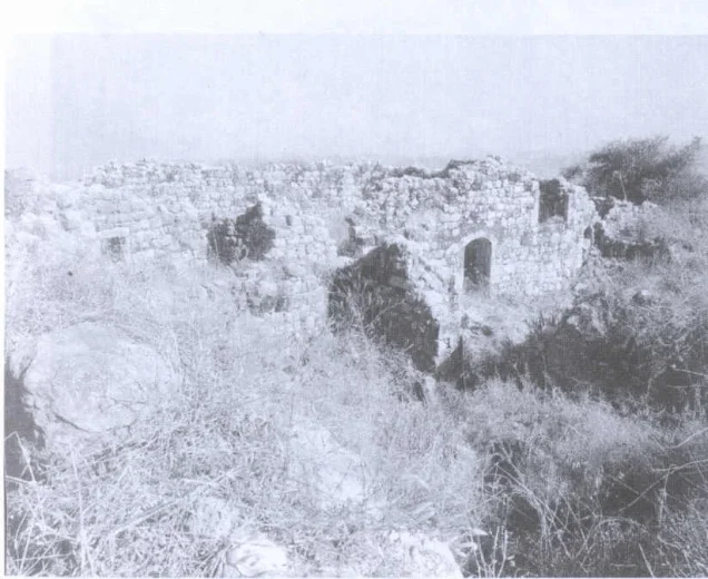
al-Mansura (Aka)
About the depopulated village of al-Mansura (Aka)
- District
- Akka (Acre)
- Military operation
- Operation Hiram
- Brigade that carried it out
- Not identified in the sources; Operation Hiram was carried out by the Seventh (Sheva'), Carmeli, Golani and Oded Brigades
- Distance from the governorate centre
- 29 km from Acre
- Elevation above sea level
- 675 m
- Cause of displacement
- Expulsion by Israeli occupation forces, who ordered the inhabitants to leave the village in mid-November 1948
- Extent of destruction
- al-Mansura was completely obliterated.
- Ethnic cleansing
- al-Mansura inhabitants were completely ethnically cleansed.
- Settlements built on the built-up area of al-Mansura (Aka) after 1948
- Elqosh (1949, on part of the village land), Biranit (early 1950s; its original name was al-Mansura), Netu'a (1966, less than 1 km from the village site), Mattat (1979) and Abbirim (1980)
Hover a dot to read the village name, or click to open its card.
Borders of the depopulated village of al-Mansura (Aka)
al-Mansura: A Depopulated Palestinian Village in the Acre District
al-Mansura was a Palestinian village in the Acre District, located in Upper Galilee approximately 29 kilometres northeast of the city of Acre, close to the Palestine–Lebanon border, at an average elevation of about 675 metres above sea level. The village remained part of Lebanon until 1923, when the international boundary placed it within Palestine. It was probably attacked during Operation Hiram in late October 1948, while its inhabitants were finally expelled in mid-November 1948.
- Subdistrict
- Acre
- Distance from district center
- 29 km from Acre
- Average Elevation
- 675 m above sea level
- Population in 1931
- 688 – joint figure for al-Mansura and Fassuta
- Number of Houses in 1931
- 129 – joint figure for al-Mansura and Fassuta
- Population in 1944/1945
- 2,300 – joint figure for al-Mansura, Fassuta and Dayr al-Qasi
- Total Land Area in 1945
- 34,011 dunams (sum of Arab-owned and public land) or 34,013 dunams (the total printed in the PalQuest table) – joint figure for the lands of al-Mansura, Fassuta and Dayr al-Qasi
- Attack and Depopulation
- Khalidi considers it probable that the village was attacked in October 1948 during Operation Hiram. In mid-November 1948 its inhabitants were ordered to leave, under the decision of the Israeli occupation forces to empty their side of the border with Lebanon of its Arab inhabitants; some crossed into Lebanon and most were taken in trucks to al-Rama.
- Final Israeli Control
- Probably October 1948, during Operation Hiram (28–31 October 1948), according to Khalidi's assessment; the available sources do not give the day on which Israeli occupation forces entered the village. The village was finally emptied of its inhabitants in mid-November 1948.
- Military Operation
- Operation Hiram
- Military Unit
- The available sources do not identify the unit that attacked or occupied the village; Operation Hiram was carried out by units from four brigades: the Seventh (Sheva') Brigade, the Carmeli Brigade, the Golani Brigade and the Oded Brigade.
- Cause of Depopulation
- Expulsion by Israeli occupation forces, who ordered the inhabitants to leave the village in mid-November 1948
- Settlements Documented on Village Lands
- Elqosh (1949, on part of the village land), Biranit (early 1950s; its original name was al-Mansura), Netu'a (1966, less than 1 km from the village site), Mattat (1979) and Abbirim (1980)
Location
al-Mansura stood on the northern shoulder of a mountain in Upper Galilee. The summit rose behind the village to the south, while lower expanses of land extended to the east, west, and north.
The village had an average elevation of approximately 675 metres above sea level and lay about 29 kilometres northeast of Acre.
A secondary road connected al-Mansura with the coastal Acre–Ra's al-Naqura highway.
al-Mansura and the Palestine–Lebanon Border
al-Mansura remained part of Lebanon until 1923, when Britain and France delineated the international frontier in the region and placed the village within Mandate Palestine.
Its history was therefore closely connected with the border region and with neighbouring Palestinian and Lebanese communities of Upper Galilee.
Architecture and Religious Life
During the British Mandate, al-Mansura was classified as a hamlet in the Palestine Index Gazetteer, and its houses were built at some distance from one another.
The population was predominantly Christian, and the village had its own church, known as the Church of Mar Yohanna.
Drinking water was obtained from a well north of the village and from three water tanks to its south.
Population
The population figures for al-Mansura require particular caution because the Government of Palestine did not publish all of the village's statistics separately from neighbouring communities.
In the 1931 census, a population of 688 was recorded, but this figure included both al-Mansura and Fassuta. The figure of 129 houses likewise refers to the combined population unit rather than al-Mansura alone.
In the 1944/1945 statistics, the combined population of al-Mansura, Fassuta, and Dayr al-Qasi was 2,300 Arabs.
Neither figure should therefore be presented as the population of al-Mansura alone, and the principal statistical sources reviewed here do not provide a reliable separate population total for the village immediately before the Nakba.
Population Figures Associated with al-Mansura
- 1931688Includes al-Mansura and Fassuta
- 1944/19452,300Includes al-Mansura, Fassuta, and Dayr al-Qasi
Number of Houses
The 1931 census recorded 129 houses, but this figure included both al-Mansura and Fassuta and therefore does not represent al-Mansura alone.
Lands of al-Mansura, Fassuta, and Dayr al-Qasi
The 1944/1945 land statistics combined al-Mansura with Fassuta and Dayr al-Qasi in a single statistical unit. These figures should therefore not be interpreted as the land area of al-Mansura alone.
The combined lands of the three villages covered approximately 34,011 dunams, including 26,619 dunams of Arab-owned land and 7,392 dunams of public land. No Jewish-owned land was recorded in the unit.
Some published versions give totals of 34,013 dunams and 7,394 dunams of public land. The figures of 34,011 and 7,392 are used here because they are mathematically consistent with the detailed land-use table published by PalQuest.
Land Ownership of al-Mansura, Fassuta, and Dayr al-Qasi in 1944/1945
- Arab ownership26,619 dunums78%
- Jewish ownership0 dunums0%
- Public land7,392 dunums22%
Agriculture and Economic Life
The economy of al-Mansura depended primarily on agriculture and animal husbandry.
Approximately 900 dunams of land belonging collectively to residents of al-Mansura, Fassuta, and Dayr al-Qasi were planted with olive trees.
In 1944/1945, 6,475 dunams of the combined lands of the three villages were devoted to cereals, while 1,617 dunams were irrigated or used for plantations.
The 900 dunams of olive trees formed part of the cultivated land and should not be added separately to the overall land-use totals.
Land Use of al-Mansura, Fassuta, and Dayr al-Qasi in 1944/1945
- Arab
- Public
- Cereals6,475 dunums
- Irrigated and plantation land1,617 dunums
- Built-up area247 dunums
- Uncultivable land25,672 dunums
Archaeology
Two archaeological khirbas near al-Mansura contained building foundations, presses, water cisterns, and the remains of a fort.
These remains indicate successive periods of human activity in the area, although the principal sources reviewed do not provide precise dates for all of these features.
The Nakba and Operation Hiram
Operation Hiram
Operation Hiram was conducted between 28 and 31 October 1948 with the objective of taking control of Upper Galilee. Forces from the Oded, Seventh, Carmeli, and Golani brigades, among other units, participated in the offensive.
The operation resulted in the occupation of numerous Palestinian villages in Upper Galilee and generated a large wave of displacement toward Lebanon and other areas.
The Attack on al-Mansura
Walid Khalidi considers it probable that al-Mansura was attacked in October 1948 during Operation Hiram.
However, the principal Palestinian sources reviewed do not establish the precise date on which Israeli forces first entered the village and do not identify a specific brigade or battalion as directly responsible for its capture.
It is therefore not sufficiently documented to attribute the occupation of al-Mansura specifically to the Carmeli Brigade alone, even though the Carmeli Brigade participated in Operation Hiram as a whole.
Occupation and Depopulation Chronology
- 28 October 1948
Beginning of the military operation
Israeli occupation forces launched Operation Hiram with units from the Sheva' (Seventh), Carmeli, Golani and Oded brigades; it lasted until 31 October 1948, and the whole of Upper Galilee was occupied during it. PalQuest lists al-Mansura among the villages affected by the operation.
- October 1948
First attack on the village
Khalidi considers it probable that the village was attacked during Operation Hiram; the available sources give neither the day of the attack nor the unit that carried it out.
- Mid-November 1948
Depopulation of the village
The Israeli occupation forces decided to empty their side of the border with Lebanon of its Arab inhabitants, and the people of al-Mansura were ordered to leave; some crossed into Lebanon, and most were taken in trucks to al-Rama, to the south.
- February 1949
Prevention of return
The Maronite church appealed to the Israeli government on behalf of the villagers, asking that they be allowed to return to their homes, but the appeal was denied; for years afterwards the pleas of the villagers who had remained in the country to the Israeli authorities were to no avail.
- 1949
Settlement on village lands
The settlement of Elqosh was established on part of the village land.
- Early 1950s
Settlement on village lands
The settlement of Biranit was built on village land; its original name was al-Mansura.
- 1966
Settlement on village lands
The settlement of Netu'a was founded on village land, less than 1 km from the village site.
- 1979–1980
Settlement on village lands
The settlements of Mattat, founded in 1979, and Abbirim, founded in 1980, were both established on village lands.
Final Expulsion in November 1948
Some inhabitants of al-Mansura remained in the area after Operation Hiram, and the village's final depopulation did not occur until mid-November 1948.
At that time, the Israeli army decided to empty Arab villages along the Israeli-controlled side of the Palestine–Lebanon border.
The residents of al-Mansura were ordered to leave. Some crossed the border into Lebanon, while most were transported by trucks southward to the Palestinian village of al-Rama.
Palestine Remembered lists 1 November 1948 as a summary occupation date. Walid Khalidi's more detailed account, however, distinguishes between the probable attack during Operation Hiram in late October and the final expulsion in mid-November. This article follows that more precise chronology.
Attempts to Return
In February 1949, the Maronite Church appealed to the Israeli government on behalf of the inhabitants of al-Mansura, requesting permission for them to return to their homes. The appeal was rejected.
Former villagers who remained inside Palestine continued for years to seek permission to return, but they were not allowed to re-establish their community in al-Mansura.
Israeli Settlements on the Lands of al-Mansura
Elqosh
Elqosh was established in 1949 on part of al-Mansura's lands.
Biranit
Biranit was established in the early 1950s on the lands of al-Mansura. According to Walid Khalidi, its original name was al-Mansura.
Netu'a
Netu'a was established in 1966 on al-Mansura's lands, less than 1 kilometre from the village site.
Mattat and Abbirim
Mattat was established in 1979 and Abbirim in 1980, both on the lands of al-Mansura.
- 1949Elqosh
Established on part of al-Mansura's lands
- Early 1950sBiranit
Established on al-Mansura's lands
- 1966Netu'a
Established on al-Mansura's lands, less than 1 kilometre from the village site
- 1979Mattat
Established on al-Mansura's lands
- 1980Abbirim
Established on al-Mansura's lands
The Site of al-Mansura After the Nakba
According to the field documentation relied upon by Walid Khalidi, the houses of al-Mansura were completely levelled, with much of the rubble piled along the northern edge of the village site.
The site was used for grazing cattle and enclosed by a wire fence, while a chicken coop belonging to Netu'a stood to the west.
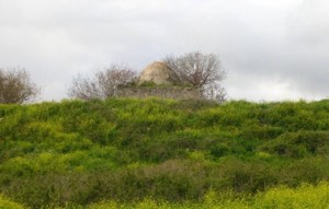
The only surviving village structure was the Church of Mar Yohanna, approximately 200 metres south of the village site on the mountain slope. Its roof and sections of its walls had collapsed at the time of Khalidi's documentation.
Vineyards were planted between the church and the village site, while a military airstrip and army base were located on the summit of the mountain to the south.
This description reflects the condition of the site during the period of field documentation relied upon by Walid Khalidi and should not necessarily be interpreted as a comprehensive survey updated to 2026.
Sources
- PalQuest – Interactive Encyclopedia of the Palestine Question: al-Mansura, Acre.
- PalQuest: al-Mansura – Acre.
- PalQuest: Operation Hiram.
- Palestine Remembered: al-Mansura, Acre District.
- Palestine Remembered: al-Mansura.
- Walid Khalidi, All That Remains, entry on al-Mansura, Acre District.
- Government of Palestine, Census of Palestine, 1931.
- Government of Palestine, Department of Statistics, Village Statistics, 1945.
Photo gallery


Photos from the village's people
Photos sent in by visitors and published after review.
Add a photo of this village
Log in to add photos of this village.
Other villages from Akka (Acre)
More from the archive



 Download Our Palestine App
The whole archive in the palm of your hand: depopulated villages, the Nakba, the massacres and Al-Aqsa — free, with no ads to erase the story.
Download Our Palestine App
The whole archive in the palm of your hand: depopulated villages, the Nakba, the massacres and Al-Aqsa — free, with no ads to erase the story.



Comments
No comments yet — be the first to write one.
Add your comment
Name and email are optional. Comments appear after review.