
The depopulated village of Khirbat ‘Iribbin / District of Akka (Acre)

Khirbat ‘Iribbin
About the depopulated village of Khirbat ‘Iribbin
- District
- Akka (Acre)
- Date Khirbat ‘Iribbin was occupied
- 30 October 1948
- Population in 1948
- 418
- Military operation
- Operation Hiram
- Brigade that carried it out
- The Oded Brigade
- Distance from the governorate centre
- 23 (km) Northeast of Acre
- Elevation above sea level
- 450 m
- Cause of displacement
- Military assault by Zionist troops
- Extent of destruction
- Khirbat 'Iribbin was completely destroyed and defaced.
- Ethnic cleansing
- 'Iribbin, Khirbat inhabitants were completely ethnically cleansed.
Hover a dot to read the village name, or click to open its card.
Khirbat 'Iribbin ('Arab al-Qulaytat) – Depopulated Palestinian Village of the Acre Subdistrict
Khirbat 'Iribbin, also known as 'Arab al-Qulaytat, was a Palestinian village in the Upper Galilee within the Acre Subdistrict. It stood on high ground along the northern side of Wadi Karkara, approximately 23 km northeast of Acre and about 450 metres above sea level.
The village lay roughly 1 km south of the Lebanese border and overlooked the Mediterranean Sea to the west, with the Bay of Haifa visible from its elevated position. It was inhabited by the Muslim Bedouin community of 'Arab al-Qulaytat. In the 1944/45 official statistics, Khirbat 'Iribbin was grouped with Jurdayh, Khirbat Idmith, and 'Arab al-Aramisha rather than being tabulated separately.
Name of Khirbat 'Iribbin
The village appears in the principal sources as Khirbat 'Iribbin, with the alternative rendering Khirbat I'ribbin. It was also known as 'Arab al-Qulaytat, after the Bedouin community that inhabited the locality.
Location
Khirbat 'Iribbin stood in the Upper Galilee, approximately 23 km northeast of Acre and around 450 metres above sea level. It occupied elevated ground on the northern side of Wadi Karkara, approximately 1 km south of the Lebanese border.
Its elevated location provided a westward view toward the Mediterranean and the Bay of Haifa. The village formed part of the cluster of Palestinian communities near the northern frontier, in the wider area of Iqrit, Tarbikha, and 'Arab al-Aramisha.
Population Before the Nakba
Khirbat 'Iribbin was inhabited by the Muslim Bedouin community of 'Arab al-Qulaytat. Population figures require particular caution because the Government of Palestine's 1944/45 statistics combined Khirbat 'Iribbin with Jurdayh, Khirbat Idmith, and 'Arab al-Aramisha.
- 1944/45360Official figure, but it covers Khirbat 'Iribbin together with Jurdayh, Khirbat Idmith, and 'Arab al-Aramisha; it is not a separate count for Khirbat 'Iribbin alone.
- 1948418Later estimate published by Palestine Remembered, not an official census. It should also be treated cautiously because the 1945 baseline covers several localities.
- 19982,565 refugeesLater estimate published by Palestine Remembered; not an official separate count for Khirbat 'Iribbin.
The 1931 census tables list 'Arab al-Qulaytat by name but do not provide a separate population total in the available village table that can safely be attributed to Khirbat 'Iribbin. No unverified 1931 figure is therefore supplied here.
Number of Houses
The principal sources reviewed do not provide a reliable separate figure for the number of houses in Khirbat 'Iribbin in 1931 or immediately before the Nakba. Because the statistical unit encompassed several localities, no house count is inferred from population figures or transferred from a wider administrative unit.
Land Ownership
The 1944/45 statistical unit encompassing Khirbat 'Iribbin, Jurdayh, Khirbat Idmith, and 'Arab al-Aramisha contained a total of 11,463 dunums.
After correcting an arithmetic/display error in the simplified Palestine Remembered table, ownership can be represented as follows:
- Palestinian11,442 dunums100%
- Transferred to Zionists0 dunums0%
- Communal/Public21 dunums<1%
These figures correspond to the official categories of 11,442 Arab dunums and 21 Public dunums. As with the population figure, however, the land total belongs to the combined statistical unit and should not be presented as though every dunum belonged solely to the built-up settlement of Khirbat 'Iribbin.
Land Use in 1944/45
Walid Khalidi's detailed village entry states that 2,637 dunums were allocated to cereals and another 16 dunums were irrigated or used for orchards, giving a total cultivable or cultivated area of 2,653 dunums.
- Arab
- Public
- Cereals2,637 dunums
- Plantations and Irrigable Land16 dunums
- Non-Cultivable Land8,810 dunums
The PalQuest summary table currently displays 2,053 dunums as the cultivable total. That figure conflicts with both the detailed entry and the arithmetic of the official figures. The documented 2,637 dunums of cereals plus 16 dunums of irrigated land and orchards equal 2,653 dunums; adding the 8,810 non-cultivable dunums produces the complete total of 11,463 dunums. The arithmetically consistent figure of 2,653 dunums is therefore used here.
Economic Life
Cereal cultivation dominated the agricultural use of the combined statistical unit. In 1944/45, 2,637 dunums were allocated to cereals, while only 16 dunums were recorded as irrigated land or orchards.
The principal sources reviewed do not provide sufficiently detailed evidence for specific local trades, workshops, presses, or other economic activities that can be attributed to Khirbat 'Iribbin itself. Such activities are therefore not added without documentation.
Water and Archaeological Remains
The khirba contained remains of buildings, foundations, columns, and water cisterns. Khalidi's later description of the depopulated site also recorded a number of wells and caves.
The principal sources do not provide a secure archaeological date for all of these remains, so they are not assigned here to a particular historical period without additional evidence.
Education and Public Services
The principal sources reviewed do not provide sufficient documentation to confirm a formal school in Khirbat 'Iribbin or to establish a founding year or enrolment figure. Nor does the core village entry provide enough verified information for a detailed account of other public institutions.
Occupation and Depopulation
Khirbat 'Iribbin lay within the large Upper Galilee pocket that remained outside Israeli control until after the second truce. On 28 October 1948, Israeli occupation forces launched Operation Hiram, a large offensive aimed at conquering the remaining area of Upper Galilee. The operation continued through 31 October.
PalQuest lists Khirbat 'Iribbin among the villages affected by Operation Hiram. Walid Khalidi states that precise information about the village is lacking, but considers it almost certain that it had been occupied by 31 October 1948.
The occupation of the locality did not necessarily coincide with the final expulsion of its inhabitants. Khalidi allows for the possibility that the residents remained for a short period and were expelled in November, in the broader clearing of Palestinian villages close to the Lebanese border and at approximately the same time as the inhabitants of nearby Iqrit.
Palestine Remembered lists 30 October 1948 as the occupation date and names the Oded Brigade as the attacking unit. Khalidi's detailed entry, however, does not independently establish 30 October as the precise date or identify the specific brigade that entered Khirbat 'Iribbin. These database fields are therefore not treated as conclusive village-specific evidence.
Operation Hiram
Operation Hiram ran from 28 to 31 October 1948 and targeted the remaining Arab-held pocket in Upper Galilee close to the Lebanese frontier. Units from several Israeli brigades participated, including Sheva', Carmeli, Golani, and Oded, and the offensive resulted in the occupation of most of Upper Galilee and the displacement or expulsion of the population of numerous Palestinian villages.
For Khirbat 'Iribbin itself, however, the principal village entry does not independently identify which brigade entered the locality. Participation by the Oded Brigade in Operation Hiram and in nearby frontier villages should therefore not automatically be converted into a definite attribution for Khirbat 'Iribbin.
Occupation Chronology
- 28 October 1948
Beginning of Operation Hiram
Israeli occupation forces launched a major offensive against the remaining pocket of Upper Galilee.
- Probably by 31 October 1948
Occupation of Khirbat 'Iribbin
Khalidi considers it almost certain that the locality had been occupied by this date, but does not identify the precise day or the specific unit that entered it.
- 30 October 1948
Date listed by Palestine Remembered
The database lists this as the occupation date, but it is more precise than the detailed Khalidi account allows.
- November 1948
Possible later expulsion
Khalidi suggests that the inhabitants may have remained after the initial occupation and been expelled in November in the wider clearing of frontier villages, around the time of the expulsion from nearby Iqrit.
Military Unit
The specific military unit that entered Khirbat 'Iribbin cannot be established with confidence from Khalidi's village entry. Palestine Remembered names the Oded Brigade, which did participate in Operation Hiram and advanced through the northern frontier sector, occupying nearby villages. This circumstantial connection, however, does not independently establish Oded as the unit that entered Khirbat 'Iribbin itself.
The most accurate formulation is therefore: Military operation: Operation Hiram; village-specific attacking unit: not independently established in the principal source.
Israeli Settlements on or Near Khirbat 'Iribbin Lands
Adamit was established in 1958 on Khirbat 'Iribbin village land to the west of the village site. Khalidi explicitly identifies it as a settlement founded on the village's land.
Goren, founded in 1950, lies south of the village site and close to Khirbat 'Iribbin's lands. Khalidi's English entry describes it as being close to village land rather than explicitly stating that it was founded on that land. It is therefore distinguished here from Adamit and is not presented as conclusively established on Khirbat 'Iribbin territory.
Khirbat 'Iribbin Today
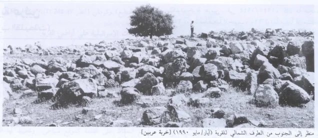
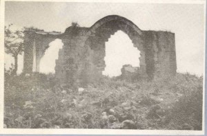
In the field description published by Walid Khalidi in All That Remains, the village site was covered with the debris of houses and contained a number of wells and caves. Remains of animal shelters lay roughly 1 km to the east, while about 4 km farther east were the ruins of houses once used by 'Arab al-Qulaytat.
Palestine Remembered hosts scans from the All That Remains documentation labelled as views of the village site in 1990. This field documentation predates the publication of Khalidi's book in 1992 and should not be represented as a direct field survey of the site's condition in 2026.
Sources
- PalQuest – Khirbat 'Iribbin
- PalQuest – Operation Hiram
- Palestine Remembered – Khirbat 'Iribbin, Acre
- Palestine Remembered – Khirbat 'Iribbin entry from Walid Khalidi's All That Remains
- Institute for Palestine Studies – Walid Khalidi, All That Remains
- Government of Palestine – Village Statistics, April 1945
- Government of Palestine – Census of Palestine 1931: Population of Villages, Towns and Administrative Areas
Photo gallery

Photos from the village's people
Photos sent in by visitors and published after review.
Add a photo of this village
Log in to add photos of this village.
Other villages from Akka (Acre)

More from the archive


 Download Our Palestine App
The whole archive in the palm of your hand: depopulated villages, the Nakba, the massacres and Al-Aqsa — free, with no ads to erase the story.
Download Our Palestine App
The whole archive in the palm of your hand: depopulated villages, the Nakba, the massacres and Al-Aqsa — free, with no ads to erase the story.



Comments
No comments yet — be the first to write one.
Add your comment
Name and email are optional. Comments appear after review.