
The depopulated village of Ayn Karim / District of Al-Quds (Jerusalem)
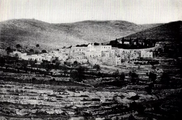
About the depopulated village of Ayn Karim
- District
- Al-Quds (Jerusalem)
- Date Ayn Karim was occupied
- 18 July 1948
- Population in 1948
- 3,690
- Brigade that carried it out
- Irgun، Gadna، Home Guard
- Elevation above sea level
- 650 m
Hover a dot to read the village name, or click to open its card.
Borders of the depopulated village of Ayn Karim
- Subdistrict
- Al-Quds (Jerusalem)
- Average Elevation
- 650 meters above sea level
- Population in 1931
- 2,637 inhabitants - Official census including Ayn al-Ruwwas and Ayn al-Khandaq
- Number of Houses in 1931
- 555 houses - The figure includes Ayn al-Ruwwas and Ayn al-Khandaq
- Population in 1944/1945
- 3,180 inhabitants - Government of Palestine statistics: 2,510 Muslims and 670 Christians
- Estimated Population in 1948
- About 3,689 inhabitants - a later demographic estimate, not an official census
- Total Land Area in 1945
- 15,029 dunams
- Attack and Depopulation
- The displacement of part of Ayn Karim's population began before the village's final occupation. PalQuest, drawing on Walid Khalidi, reports that some residents left in April 1948 following the massacre at nearby Dayr Yasin, located about 2.5 kilometres northeast of Ayn Karim.
- Final Israeli Control
- 18 July 1948
- Military Unit
- Irgun, Gadna, Home Guard
Ayn Karim: A Depopulated Palestinian Village in the Jerusalem District
Ayn Karim was a Palestinian village in the Jerusalem District, located about 7.5 kilometres west of the city of Jerusalem, at an average elevation of approximately 650 metres above sea level. It was one of the largest villages in the district in terms of population and land area. A composite Zionist military force occupied the village on 18 July 1948, and its inhabitants were displaced during the Nakba and the occupation of Palestine in 1948.
Location
Ayn Karim was divided into an upper section built on agricultural terraces and a lower section situated in a valley to the west and below the upper part. The terraces extended across hills rising toward the east, while a broad valley lay below the village to the west.
The waters of Wadi Ahmad flowed westward through the village lands and irrigated olive groves in the northern part of Ayn Karim.
Ayn Karim was considered one of the suburbs of Jerusalem. A stone-paved road connected it with the main Jerusalem–Jaffa road, which passed approximately 3 kilometres north of the village.
Ayn Karim Through History
Archaeological evidence indicates that the site of Ayn Karim had been inhabited since at least the second millennium BCE.
The village is associated with longstanding Christian religious traditions. Christian tradition identifies it as the birthplace of John the Baptist and associates it with the visit of the Virgin Mary to Elizabeth. During the Crusader period, the village was known as “St. Jehan de Bois.”
Ottoman records indicate that in 1596 Ayn Karim was a village in the Jerusalem subdistrict of the Jerusalem district, with an estimated population of about 160. Its inhabitants paid taxes on crops and products including cereals, goats, beehives, carob molasses, and vineyards.
The principal sources reviewed do not provide sufficient evidence for the claim that the word “Karim” means “the Virgin” in Syriac. This linguistic interpretation has therefore not been adopted in this article.
Architecture and Social Life
Ayn Karim was one of the largest villages in the Jerusalem District. Most of its houses were constructed of limestone and chalk stone, and many were distinguished by arched doors and windows.
The village population was organized into five extended family groups, each of which had a courtyard where members and guests gathered for social occasions.
Ayn Karim had a local council that administered village affairs. It also contained a library, a pharmacy, sports and social clubs, and a boys' scout association. Cultural activities included theatrical performances and an open-air theatre.
Notable Figures from Ayn Karim
One of the most prominent figures from the village was Shaykh Isa Manun, who became Dean of the Faculty of Usul al-Din at al-Azhar in 1944 and later Dean of the Faculty of Sharia in 1946.
Palestinian sources also report, though not conclusively, that Ayn Karim served as a secret headquarters used by Palestinian commander Abd al-Qadir al-Husayni to direct some of his operations during the Great Palestinian Revolt of 1936–1939. This account is therefore presented as a historical tradition rather than as a fully established fact.
Population
The population of Ayn Karim was 1,735 in the 1922 census. In the 1931 census, the population increased to 2,637, with the statistical unit also including Ayn al-Ruwwas and Ayn al-Khandaq.
In the 1944/1945 Village Statistics, the population stood at 3,180, including 2,510 Muslims and 670 Christians.
The figure of approximately 3,689 inhabitants for 1948, published by Palestine Remembered, is a later estimate rather than an official Government of Palestine census. The same applies to the estimate of 22,653 refugees and descendants in 1998.
Population of Ayn Karim
- 1596160Historical figure based on Ottoman records
- 19221,735Official census
- 19312,637Official census including Ayn al-Ruwwas and Ayn al-Khandaq
- 1944/19453,180Government of Palestine statistics: 2,510 Muslims and 670 Christians
- 1948About 3,689Estimate published by Palestine Remembered
- 199822,653Estimate of refugees and their descendants
Number of Houses
The 1931 census recorded 555 houses in the statistical unit that included Ayn Karim, Ayn al-Ruwwas, and Ayn al-Khandaq.
Number of Houses in Ayn Karim in 1931
- 1931555The figure includes Ayn al-Ruwwas and Ayn al-Khandaq
Education and Public Facilities
Ayn Karim had two elementary schools, one for boys and another for girls. The village also had a library, a pharmacy, sports and social clubs, and a boys' scout association.
Sources indicate that the Franciscans established a boys' school in the village during the nineteenth century, while the Sisters of Zion operated a school and an orphanage for girls.
Religious Landmarks
Ayn Karim contained a number of Muslim and Christian religious institutions. Near Ayn Maryam, or Mary's Spring, stood a mosque with a minaret known as the Umari Mosque.
The village also contained several churches and monasteries, including the Church of St. John the Baptist, the Franciscan monastery, the Church of the Visitation, the Monastery of St. Zacharias, and the Church of Our Lady of Zion.
Some of these sites are associated with Christian traditions concerning the birth of John the Baptist and the visit of the Virgin Mary to Elizabeth. These religious traditions should be distinguished from historical or archaeological proof.
Land of Ayn Karim
According to the 1944/1945 statistics, the total land area of Ayn Karim amounted to 15,029 dunams. Arabs owned 13,449 dunams, Jews owned 1,362 dunams, and 218 dunams were classified as public land.
Land Ownership in Ayn Karim in 1944/1945
- Arab ownership13,449 dunums89%
- Jewish ownership1,362 dunums9%
- Public land218 dunums1%
Agriculture and Economic Life
The economy of Ayn Karim depended heavily on agriculture. Villagers constructed agricultural terraces along the mountain slopes and cultivated olives, grapevines, fruit trees, and vegetables.
In the 1944/1945 statistics, a total of 1,199 dunams were devoted to cereals, including 1,175 dunams of Arab-owned land and 24 dunams of Jewish-owned land.
A total of 7,960 dunams were irrigated or used for plantations, including 7,953 Arab-owned dunams and 7 Jewish-owned dunams.
Villagers also worked in crafts and light industries, including a mineral-water bottling plant.
Land Use in Ayn Karim in 1944/1945, in Dunams
- Arab
- Jewish
- Public
- Cereals1,199 dunums
- Irrigated and plantation land7,960 dunums
- Built-up area1,704 dunums
- Uncultivable land4,166 dunums
Palestine Remembered also publishes a figure of approximately 4,300 dunams planted with olive trees. This figure is not included as a separate category in the table above because the official PalQuest land-use table does not list olives as an independent category within the 1944/1945 classification.
Archaeology
Sources indicate that Ayn Karim lies in an area with a long history of settlement dating back at least to the second millennium BCE.
Palestinian sources record rock-cut tombs, mosaic remains, and building foundations in and around the village, as well as nearby archaeological khirbas.
The Nakba and the Occupation of Ayn Karim
The displacement of part of Ayn Karim's population began before the village's final occupation. PalQuest, drawing on Walid Khalidi, reports that some residents left in April 1948 following the massacre at nearby Dayr Yasin, located about 2.5 kilometres northeast of Ayn Karim.
The Military Force that Attacked the Village
During the ten days between the two truces, from 9 to 18 July 1948, Ayn Karim was surrounded by a composite military force that included elements of the Irgun, Gadna, the Haganah youth battalions, and the Home Guard.
The principal Palestinian sources reviewed do not identify a separate named military operation for the occupation of Ayn Karim. The village's occupation is therefore not attributed here to Operation Dani or to another operation without direct documentation.
The Final Assault on 18 July
The final assault on Ayn Karim began at approximately 2:00 a.m. on 18 July 1948, when the attacking forces advanced toward the heights of Jabal Rab overlooking the village.
By approximately 9:00 a.m., the village had come under Israeli control. Sources indicate that most of its inhabitants had left by that time.
The accounts reproduced by PalQuest differ regarding the precise timing of the population's departure. Some indicate that displacement began in April, while others place a significant phase of the exodus in July. It is therefore more accurate to understand the displacement of Ayn Karim as a process that occurred in stages and culminated with the military occupation of the village on 18 July 1948.
Fate of the Population and Buildings
The Palestinian inhabitants of Ayn Karim were displaced during the Nakba, and the original village community was prevented from re-establishing itself in the village after the occupation.
Unlike many other depopulated Palestinian villages, Ayn Karim was not completely demolished. A large part of its historic housing and built environment remained standing, and the surviving houses were later used to accommodate new residents.
By the end of December 1948, sources indicate that approximately 150 Jewish families had been housed in the buildings of Ayn Karim after the village was incorporated into Israeli-controlled western Jerusalem.
Occupation and Depopulation Chronology
- April 1948
The Nakba and the Occupation of Ayn Karim
The displacement of part of Ayn Karim's population began before the village's final occupation. PalQuest, drawing on Walid Khalidi, reports that some residents left in April 1948 following the massacre at nearby Dayr Yasin, located about 2.5 kilometres northeast of Ayn Karim.
- 18 July 1948
The Military Force that Attacked the Village
During the ten days between the two truces, from 9 to 18 July 1948, Ayn Karim was surrounded by a composite military force that included elements of the Irgun, Gadna, the Haganah youth battalions, and the Home Guard. The principal Palestinian sources reviewed do not identify a separate named military operation for the occupation of Ayn Karim.
Israeli Settlements and Projects Established on the Lands of Ayn Karim
Beit Zayit
The settlement of Beit Zayit was established in 1949 on the lands of Ayn Karim, according to Walid Khalidi and PalQuest.
Even Sapir
The settlement of Even Sapir was established in 1949 on the lands of the village.
Ayn Karim Agricultural School
The Ayn Karim Agricultural School was established in 1950 on village lands.
Large additional areas of Ayn Karim's lands were incorporated into the Israeli municipality of western Jerusalem.
| Name | Year Established | Description |
|---|---|---|
| Beit Zayit | 1949 | Established on the lands of Ayn Karim |
| Even Sapir | 1949 | Established on the lands of Ayn Karim |
| Ayn Karim Agricultural School | 1950 | Established on village lands |
The Site of Ayn Karim After the Nakba
According to the field documentation published by Walid Khalidi, Ayn Karim is one of the relatively few depopulated Palestinian villages in which a large part of the original built environment survived.
Large stone houses of two or three storeys remained standing, many distinguished by arched windows and doors. Several churches and monasteries also survived, along with the Christian and Muslim cemeteries, the Umari Mosque and its minaret, and Ayn Maryam.
Walid Khalidi also records the establishment of the Israeli Hadassah Hospital in the village area, in addition to tourism-related facilities northeast of the site.
Details concerning who occupied particular houses and how individual buildings were being used reflect the period of Khalidi's field documentation and should not be interpreted as a comprehensive field survey of the site in 2026.
Sources
- PalQuest – Interactive Encyclopedia of the Palestine Question: Ayn Karim.
- Palestine Remembered: Ayn Karim, Jerusalem District.
- Walid Khalidi, All That Remains: Historical account of Ayn Karim, reproduced by Palestine Remembered.
- Institute for Palestine Studies: Palestinian village histories and sources relating to the Jerusalem District.
- Institute for Palestine Studies: Villages of the Jerusalem District in 1948.
- Walid Khalidi, All That Remains, entry on Ayn Karim.
- Government of Palestine, Department of Statistics, Village Statistics, 1945.
- 1931 Census of Palestine, with the note that the Ayn Karim statistical unit included Ayn al-Ruwwas and Ayn al-Khandaq.
```
Photo gallery


Photos from the village's people
Photos sent in by visitors and published after review.
Add a photo of this village
Log in to add photos of this village.
Other villages from Al-Quds (Jerusalem)
More from the archive
 Al-Quds (Jerusalem)
The depopulated village of Khirbat al-Tannur - Allar al-Sifla / District of Al-Quds (Jerusalem)
 Al-Quds (Jerusalem)
The depopulated village of Jarash / District of Al-Quds (Jerusalem)
 Al-Quds (Jerusalem)
The depopulated village of al-Burayj (Bayarat Burayj) / District of Al-Quds (Jerusalem)
 Download Our Palestine App
The whole archive in the palm of your hand: depopulated villages, the Nakba, the massacres and Al-Aqsa — free, with no ads to erase the story.
Download Our Palestine App
The whole archive in the palm of your hand: depopulated villages, the Nakba, the massacres and Al-Aqsa — free, with no ads to erase the story.



Comments
No comments yet — be the first to write one.
Add your comment
Name and email are optional. Comments appear after review.