
The depopulated village of Khirbat Ism Allah / District of Al-Quds (Jerusalem)

Khirbat Ism Allah
About the depopulated village of Khirbat Ism Allah
- District
- Al-Quds (Jerusalem)
- Date Khirbat Ism Allah was occupied
- 17 July 1948
- Population in 1948
- 20
- Military operation
- Operation Dani
- Brigade that carried it out
- Harel Brigade
- Distance from the governorate centre
- 26 (km) West of Jerusalem
- Elevation above sea level
- 300 m
- Extent of destruction
- Khirbat Ism Allah was mostly destroyed with the exception of few deserted houses.
- Ethnic cleansing
- Ism Allah, Khirbat inhabitants were completely ethnically cleansed.
Hover a dot to read the village name, or click to open its card.
Khirbat Ism Allah – Depopulated Palestinian Village in Jerusalem Subdistrict
Khirbat Ism Allah was a Palestinian village in the Jerusalem subdistrict. It stood approximately 26 kilometers west of Jerusalem at an average elevation of about 300 meters above sea level.
The village occupied the western slope of a hill and consisted of two separate clusters of stone houses. Several caves north of the site were also used as dwellings. A spring west of the village supplied water, and numerous caves surrounded the locality.
Khirbat Ism Allah had 20 Arab Muslim inhabitants in the official 1944/45 statistics and a registered land area of 568 dunums, all classified as Arab-owned.
Walid Khalidi considers it probable that the Har'el Brigade occupied Khirbat Ism Allah on 17–18 July 1948 during Operation Dani. Palestine Remembered gives 17 July as the specific occupation date.
Key Facts about Khirbat Ism Allah
| Field | Information |
|---|---|
| Name | Khirbat Ism Allah |
| Subdistrict | Jerusalem |
| Distance from Jerusalem | Approximately 26 km west |
| Average elevation | Approximately 300 m above sea level |
| Population, 1931 | 18 in 4 houses |
| Population, 1944/45 | 20 Arab Muslims |
| Registered land area | 568 dunums |
| Occupation date | 17–18 July 1948; Palestine Remembered gives 17 July |
| Military operation | Operation Dani |
| Military unit | Har'el Brigade, according to Khalidi's reconstruction |
| Cause of depopulation | Military overrun during Operation Dani; no detailed independent account of each family's departure survives in Khalidi's entry |
| Extent of destruction | Most buildings were destroyed, while several houses, caves, and stone walls survived |
| Israeli settlements on village land | None documented |
The Name Khirbat Ism Allah
Ism Allah literally means “Name of God” in Arabic.
Walid Khalidi explicitly states that the reason for this designation is unknown.
No unsupported religious legend or shrine tradition has therefore been added to explain the name.
Location
Khirbat Ism Allah stood on the western slope of a hill in the western part of the Jerusalem subdistrict.
Secondary roads and dirt tracks connected it with the highways running from Gaza and Bayt Jibrin and with the Jerusalem–Jaffa road.
This placed the hamlet within the network of small localities along secondary approaches to the Jerusalem corridor, an area of considerable military significance in 1948.
Village Layout and Dwellings
The village consisted of two separate clusters of houses on the western slope.
Several nearby caves to the north were also used as dwellings.
The village houses were built of stone, as were the constructed entrances attached to the inhabited caves, turning some natural caves into residential spaces.
Only a few families lived in the hamlet, and all were Muslim.
Population
- 193118Official census, living in 4 houses
- 1944/4520Official Village Statistics; all Arab Muslims
- 194823Later Palestine Remembered estimate, not an official census
- 1998143Later estimate of refugees and descendants reported by Palestine Remembered
The 1948 and 1998 figures are later estimates and should not be described as figures produced by the British Mandatory census authorities.
Number of Houses
| Year | Houses | Nature of Figure |
|---|---|---|
| 1931 | 4 | Official Census of Palestine figure |
| 1948 | Not available | No independently documented house total in the principal sources reviewed |
The number of residential spaces may nevertheless have exceeded the conventional house count because several caves were also occupied as dwellings.
Land Ownership
The total registered village land area in 1944/45 was 568 dunums.
- Palestinian / Arab568 dunums100%
- Transferred to Zionists0 dunums0%
- Communal/Public0 dunums0%
All registered village land was classified as Arab-owned.
Palestine Remembered contains a typographical inconsistency: its individual ownership rows total 568 dunums, but the displayed overall total is 567. PalQuest and the underlying 1944/45 statistics give the correct total as 568 dunums.
Land Use in 1944/45
- Cereals485 dunums85%
- Plantations and irrigable land3 dunums<1%
- Non-cultivable land80 dunums14%
The figures balance exactly: 485 + 3 + 80 = 568 dunums.
PalQuest does not provide a separate built-up acreage for Khirbat Ism Allah, so no estimated built-up figure has been inserted.
Economic Life
Agriculture was the principal economic activity despite the village's very small population.
Cereal cultivation dominated the land-use pattern, with 485 dunums devoted to grain in 1944/45.
A further 3 dunums were irrigated or used for orchards.
The very large cereal acreage relative to the small number of residents reflects the agricultural character of the hamlet and its surrounding lands.
Water and the Village Spring
A spring west of Khirbat Ism Allah supplied water to the villagers.
The spring remained visible and in use in Khalidi's later field description.
Numerous caves also surrounded the site, several of which had formed part of the residential landscape.
Education and Public Institutions
Khalidi and PalQuest do not document an independent school, mosque, market, or other public institution in Khirbat Ism Allah.
Given that the official population was only 20 in 1944/45, such institutions should not be inferred without direct evidence.
Archaeological Site
The village houses stood at the southern edge of an older archaeological khirba.
The archaeological locality contained wall foundations and a well.
The nineteenth-century Survey of Western Palestine likewise recorded building foundations at the site.
The principal sources do not securely date these remains, so no specific archaeological period has been assigned without specialist evidence.
Operation Dani
Operation Dani began on 9 July 1948 and continued until 18 July.
It was one of the largest offensives launched during the “Ten Days” between the two truces and unfolded in two principal stages.
The first stage, from 9 to 12 July, focused on Lydda, Ramla, and surrounding communities.
The second stage, from 13 to 18 July, pushed eastward toward the Jerusalem corridor and the Ramallah–Latrun road, widening the corridor already opened between the coast and Jerusalem.
PalQuest explicitly lists Khirbat Ism Allah among the localities affected by Operation Dani.
Occupation and Depopulation
Walid Khalidi does not assign an absolutely certain single-day occupation date to Khirbat Ism Allah.
Based on the hamlet's location and the military sequence in the area, he considers it probable that the Har'el Brigade captured it on 17–18 July 1948 together with a chain of villages along a secondary road leading toward Jerusalem.
Palestine Remembered gives 17 July 1948 as the specific occupation date and identifies the Har'el Brigade in the context of Operation Dani.
The most precise formulation is therefore that Khirbat Ism Allah was occupied on 17–18 July 1948 during the second stage of Operation Dani, probably by the Har'el Brigade, with Palestine Remembered specifying 17 July.
Khalidi does not provide a separate village-specific expulsion order or a detailed route of departure for the residents, so no such detail has been added without evidence.
Ethnic Cleansing
Palestine Remembered characterizes the final outcome at Khirbat Ism Allah as complete ethnic cleansing.
Khalidi establishes that the village was occupied and depopulated during Operation Dani but does not provide a detailed account of the precise mechanism by which each resident left.
The term “ethnic cleansing” is therefore retained as an attributed characterization used by Palestine Remembered, while the directly established descriptive fact is the disappearance of Khirbat Ism Allah's Palestinian community following the occupation.
Occupation Chronology
- 9 July 1948
Beginning of Operation Dani
The offensive began in the Lydda–Ramla area and the Jerusalem corridor.
- 9–12 July 1948
First stage
The operation concentrated on Lydda, Ramla, and surrounding villages.
- 13–18 July 1948
Second stage
Forces pushed eastward toward the Ramallah–Latrun road and the Jerusalem corridor.
- 17–18 July 1948
Occupation of Khirbat Ism Allah
Khalidi considers capture during this period by the Har'el Brigade probable; Palestine Remembered specifies 17 July.
- During the occupation
Depopulation
The Palestinian community disappeared from the hamlet; Khalidi provides no village-specific expulsion order or detailed departure route.
- 18 July 1948
End of Operation Dani
The operation ended with the close of the Ten Days fighting.
- Precise date not documented
Destruction
Most of the built-up hamlet was destroyed, although several houses, caves, and low stone walls survived.
Israeli Settlements and Khirbat Ism Allah's Lands
Khalidi and PalQuest identify no Israeli settlement as having been established directly on Khirbat Ism Allah's village lands.
| Settlement | Established | Relationship to Khirbat Ism Allah |
|---|---|---|
| Kefar Uriyya / Kfar Uria | 1944 | Established approximately 1.5 km northwest of the village site, close to but not on Khirbat Ism Allah's land |
Kfar Uria should therefore not be described as a settlement established on Khirbat Ism Allah's lands despite its close proximity to the site.
Khirbat Ism Allah Today
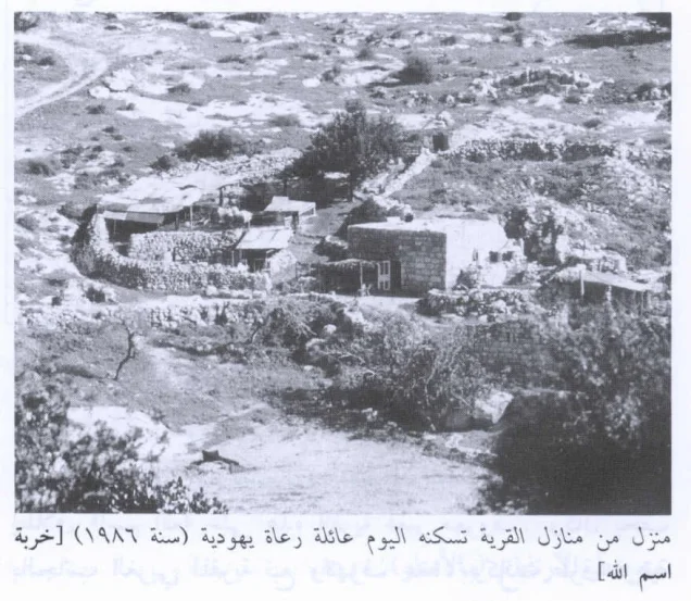
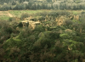
According to Walid Khalidi's field description, caves in the northern part of the site still showed evidence of their former use as dwellings, including the remains of arched entrances.
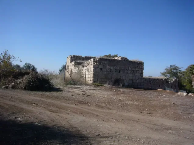
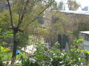
In the southern part, several ruined houses remained surrounded by low stone walls.
By the period of Khalidi's documentation, a Jewish shepherd family had settled at the site, renovated one of the houses, and used the enclosed area as a goat pen.
The wider site had become grazing land, while the family continued to draw water from the former village spring to the west.
This account derives from fieldwork undertaken before the publication of All That Remains in 1992 and is therefore a documented historical site description rather than comprehensive direct field verification of conditions in 2026.
Sources
Photo gallery
Photos from the village's people
Photos sent in by visitors and published after review.
Add a photo of this village
Log in to add photos of this village.
Other villages from Al-Quds (Jerusalem)
More from the archive
 Al-Quds (Jerusalem)
The depopulated village of Khirbat al-Tannur - Allar al-Sifla / District of Al-Quds (Jerusalem)
 Al-Quds (Jerusalem)
The depopulated village of Jarash / District of Al-Quds (Jerusalem)
 Al-Quds (Jerusalem)
The depopulated village of al-Burayj (Bayarat Burayj) / District of Al-Quds (Jerusalem)
 Download Our Palestine App
The whole archive in the palm of your hand: depopulated villages, the Nakba, the massacres and Al-Aqsa — free, with no ads to erase the story.
Download Our Palestine App
The whole archive in the palm of your hand: depopulated villages, the Nakba, the massacres and Al-Aqsa — free, with no ads to erase the story.



Comments
No comments yet — be the first to write one.
Add your comment
Name and email are optional. Comments appear after review.