
The depopulated village of 'Islin / District of Al-Quds (Jerusalem)
About the depopulated village of 'Islin
- District
- Al-Quds (Jerusalem)
- Date 'Islin was occupied
- 18 July 1948
- Population in 1948
- 300
- Military operation
- Operation Dani
- Brigade that carried it out
- Harel Brigade
- Distance from the governorate centre
- 21 (km) West of Jerusalem
- Elevation above sea level
- 280 m
- Cause of displacement
- Military assault by Zionist troops
- Extent of destruction
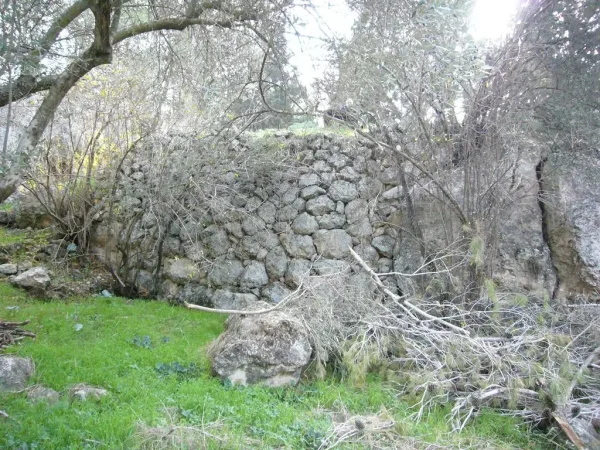
- 'Islin was completely defaced, and only house rubble left behind.
- Ethnic cleansing
- 'Islin inhabitants were completely ethnically cleansed.
Hover a dot to read the village name, or click to open its card.
Islin – Depopulated Palestinian Village of Jerusalem
Islin was a Palestinian village in the Jerusalem Subdistrict, situated in the western foothills of the Jerusalem mountains approximately 21 kilometers west of Jerusalem and at an average elevation of about 280 meters above sea level.
The village stood on a plateau along the southern slope of a mountain, with a wadi running along its western and southern sides. It lay approximately one kilometer west of the road linking Bayt Jibrin with the Jerusalem-Jaffa highway. Dirt tracks connected it with neighboring Ishwa', 'Artuf, Sar'a, Bayt Susin, and Bayt Mahsir.
Islin had a population of 260 in the official 1944/45 statistics and a total land area of 2,159 dunums. Its economy was based primarily on rain-fed agriculture, including cereals, fruit trees, olives, and vineyards, while springs and wells supplied drinking water.
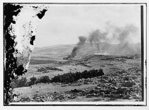
Forces of the Har'el Brigade occupied Islin during the second phase of Operation Dani on the night of 17–18 July 1948. The village and neighboring communities were subjected to mortar fire. Some residents had already left the front-line area before the final assault; most of those remaining fled as Har'el forces approached and the bombardment began, while those who remained at the village sites were expelled.
Basic Information
| Field | Information |
|---|---|
| Name | Islin / 'Islin |
| Arabic name | عِسْلين |
| Subdistrict | Jerusalem |
| Location | West of Jerusalem in the western foothills of the Jerusalem mountains |
| Distance from Jerusalem | Approximately 21 km according to Khalidi and PalQuest; some Palestinian sources give approximately 28 km |
| Average elevation | Approximately 280 m above sea level |
| Palestine Grid | 150/132 |
| Population in 1922 | 132, all Muslims |
| Population in 1931 | 186, all Muslims |
| Houses in 1931 | 49 |
| Population in 1944/45 | 260 |
| 1948 population estimate | 302 – later estimate, not an official 1948 census |
| Total land area | 2,159 dunums |
| Occupation date | Night of 17–18 July 1948; 18 July is commonly used as the occupation date |
| Military operation | Operation Dani – second phase |
| Military unit | Second Platoon, B Company, Fourth Battalion, Har'el Brigade |
| Cause of depopulation | Earlier flight under wartime pressure followed by mortar bombardment and military assault; most remaining residents fled and those still present were expelled |
| Extent of destruction | Most of the village was destroyed, although partial walls, stone terraces, and rubble survived |
| Post-1948 settlement | Eshta'ol, founded in 1949 on lands belonging to Islin and neighboring Ishwa' |
Name and Earlier History
Walid Khalidi identifies Islin with the sixteenth-century village of Islit recorded in Ottoman tax registers.
In 1596, the village belonged to the nahiya of Ramla within the Gaza administrative district and had an estimated population of approximately seventy-seven. Taxes were levied on wheat, barley, fruit trees, goats, and beehives.
Palestinian local documentation preserves several explanations for the village name, including interpretations connecting it with fertile land and older Canaanite names. These proposed etymologies are not independently established with sufficient linguistic evidence and are therefore not adopted as definitive.
Abandonment and Resettlement
In the 1870s, the site was recorded by the Survey of Western Palestine as uninhabited, although ruins of the earlier village remained visible.
Khalidi considers it probable that the site was permanently resettled around the beginning of the twentieth century.
Palestinian oral and local historical accounts associate an earlier destruction of Islin with nineteenth-century fighting during the period of Ibrahim Pasha and describe families returning afterward. Because the site was still recorded as uninhabited in the 1870s, the exact chronology of permanent resettlement remains uncertain. This article therefore follows Khalidi's more cautious formulation.
Location and Geography
Islin stood on a plateau along the southern slope of one of the western Jerusalem hills. A wadi bordered the site on its western and southern sides.
The village was approximately one kilometer west of the road connecting Bayt Jibrin with the Jerusalem-Jaffa highway, providing access toward Bab al-Wad, Jerusalem, and Jaffa.
Dirt tracks linked Islin with Ishwa', 'Artuf, Sar'a, Bayt Susin, and Bayt Mahsir. The village depended especially on neighboring Ishwa' for a number of services and commercial connections.
Built Environment
Islin consisted of two principal sections, eastern and western, with later construction extending beyond the older village core.
Houses were built primarily of stone and mud, and the official built-up area in 1944/45 covered approximately 20 dunums.
Palestinian local documentation describes the eastern section as containing part of the older village core, while families resettling the locality expanded particularly into its western section.
Population
- 1596Approx. 77Estimate derived from an Ottoman tax register
- 1922132Official Government of Palestine census; all Muslims
- 1931186Official census; 102 males and 84 females, all Muslims
- 1944/45260Official Mandate-period estimate
- 1948302Later Palestinian estimate, not a census conducted in 1948
- 19981,852Later Palestine Remembered estimate of refugees and descendants
Number of Houses
The official 1931 Census of Palestine recorded 49 houses in Islin.
Some secondary sources incorrectly give forty houses, but the original census table clearly records forty-nine.
No official house census was conducted in 1948. Palestine Remembered gives a later estimate of seventy-nine houses, while Palestinian local documentation gives approximately sixty. Neither should be presented as an official Government of Palestine count.
Land Ownership, 1944/45
- Palestinian2,157 dunums100%
- Transferred to Zionists0 dunums0%
- Public2 dunums<1%
The original Government of Palestine table used the categories Arab, Jewish, and Public. No land was recorded in the Jewish ownership category.
The figures balance exactly: 2,157 + 2 = 2,159 dunums.
Land Use, 1944/45
- Palestinian
- Public
- Cereals830 dunums
- Plantations and irrigable land104 dunums
- Built-up area20 dunums
- Non-cultivable land1,205 dunums
The land-use figures balance exactly: 830 + 104 + 20 + 1,205 = 2,159 dunums.
Olive Cultivation
Palestine Remembered separately lists approximately 25 dunums planted with olives.
This is a crop-specific figure within cultivated land rather than an additional official land-use category. It is therefore not added again to the 2,159-dunum total.
Economy and Agriculture
Islin's economy was based primarily on rain-fed agriculture and livestock raising.
Cereals occupied the largest recorded cultivated area, alongside fruit trees, olives, and vineyards. The principal agricultural lands extended north and southeast of the village site.
The sixteenth-century tax record likewise documented wheat, barley, fruit trees, goats, and beehives, demonstrating the long agricultural history of the site.
Water Resources
The inhabitants obtained drinking water from local springs and wells.
Agriculture was predominantly rain-fed, making cereals and Mediterranean tree crops particularly important to the village economy.
Education
According to Palestinian local documentation, Islin did not initially have its own independent school, and children attended schools in neighboring villages.
In 1944, a joint school serving Ishwa', Islin, 'Artuf, and Sar'a was reportedly established in a location convenient to the four villages.
The local account states that the school building stood on Islin land although it was known as the Ishwa' Government School, and that instruction reached the seventh grade.
These details derive from Palestinian community documentation and are not supplied in Khalidi's shorter village profile, so they remain explicitly attributed.
Mosque, Cemetery, and Shrine
Palestinian local documentation records a small old mosque in Islin where congregational prayers were held, with the village cemetery lying to the north.
The same documentation records a shrine or religious landmark in the western part of the village lands, associated in local tradition with Shaykh Abu Qabus.
A locally published translation of a sixteenth-century Ottoman document also refers to an imam and olive trees endowed for the village mosque.
Because these details are not all independently described by Khalidi, no unsupported construction date or architectural description is added.
Archaeology and Historical Identification
Khalidi identifies Islin with the sixteenth-century settlement of Islit documented in Ottoman records.
Local traditions that identify Islin directly with specific Canaanite or Roman towns are more contested. In particular, ancient Eshta'ol is more commonly associated with neighboring Ishwa' or Dayr Abu al-Qabus, and such identifications should not be transferred automatically to Islin.
Khirbat Dayr Abu al-Qabus, north of the village, is part of the wider archaeological landscape, but its precise historical identification requires specialist archaeological evidence.
Operation Dani
Operation Dani began on 9 July 1948 and ended on 18 July. It was the largest military offensive launched during the Ten Days between the two truces.
During its first phase, from 9 to 12 July, Israeli forces captured Lydda and al-Ramla and numerous surrounding villages.
The second phase, from 13 to 18 July, focused on extending control toward al-Latrun, the Ramallah-al-Latrun road, and villages along the Jerusalem corridor.
Islin, Ishwa', 'Artuf, Sar'a, and several other Jerusalem-area villages were affected during this second phase.
The Assault on Islin – Night of 17–18 July 1948
Islin and neighboring villages were subjected to mortar fire during the final phase of Operation Dani.
The available sources place their capture during the night of 17–18 July 1948, with 18 July commonly used as Islin's occupation date.
The village had already been situated along an active front for several months, and a portion of the population had left the area before the final assault.
Military Unit
PalQuest's account of neighboring 'Artuf provides unusually specific information about the force operating along the same axis.
The attacking formation was the Fourth Battalion of the Har'el Brigade, specifically the Second Platoon of B Company.
Armed with mortars and machine guns, this platoon first drove the remaining inhabitants from Ishwa' and Islin and then continued toward 'Artuf.
This is therefore the most precise military-unit attribution available for Islin and is preferable to assigning all brigades involved in Operation Dani to the village.
Cause of Depopulation
Palestine Remembered classifies the depopulation as resulting from direct military assault.
The more detailed account shows a staged process. Villages along this front had been under military pressure since spring 1948, and many inhabitants had already left before the final operation.
As Har'el forces approached on 17–18 July and mortar fire began, most of the remaining inhabitants fled. The small number of people still present when the forces entered the villages were expelled.
The most accurate formulation is therefore: earlier flight under prolonged wartime pressure, followed by mortar bombardment and direct military assault, with the remaining residents fleeing and the few still present being expelled.
Destruction
Most of Islin's built environment was destroyed after the village was occupied.
Descriptions stating that it was completely erased require qualification: Khalidi's fieldwork still recorded partially standing walls, stone terraces, and substantial stone rubble.
The more precise description is therefore extensive destruction of the village as a functioning community, with visible architectural remains surviving at the site.
Ethnic Cleansing in Source Classification
Palestine Remembered uses the term “complete ethnic cleansing” to classify Islin's depopulation. The term is retained here only as an attributed source classification.
The directly documented sequence consists of earlier population flight under wartime pressure, mortar bombardment and a Har'el Brigade assault, the flight of most remaining residents, the expulsion of those still present, and the prevention of the original Palestinian community from re-establishing permanent residence in the village.
Occupation Chronology
| Date | Event |
|---|---|
| Spring 1948 | The Bab al-Wad and Jerusalem corridor become a major zone of fighting, increasing military pressure on surrounding Palestinian villages. |
| Before July 1948 | Part of the population of villages along the front leaves as fighting and insecurity intensify; no household-by-household departure chronology is available for Islin. |
| 9 July 1948 | Operation Dani begins. |
| 13 July 1948 | The second phase of Operation Dani begins, extending toward al-Latrun and the Jerusalem corridor. |
| Night of 17–18 July 1948 | Islin and neighboring villages are subjected to mortar fire as the Fourth Battalion of the Har'el Brigade advances. |
| Night of 17–18 July 1948 | The Second Platoon of B Company drives the remaining inhabitants from Ishwa' and Islin before advancing toward 'Artuf. |
| 18 July 1948 | Islin is under final Israeli military control as Operation Dani reaches its end. |
| After occupation | Most of the village's built environment is demolished, although walls, terraces, and rubble remain visible. |
| 1949 | Eshta'ol is established on lands belonging to Islin and neighboring Ishwa'. |
Israeli Settlements on Islin's Lands
The settlement of Eshta'ol was established in 1949 on lands belonging jointly to Islin and neighboring Ishwa'.
Khalidi and PalQuest identify this land relationship directly, so Eshta'ol is properly listed among the settlements established on Islin's village lands.
Other nearby localities should not be added merely because of geographical proximity unless cadastral evidence places them within Islin's boundaries.
Islin Today
According to the field description used by Walid Khalidi before the publication of All That Remains in 1992, partially destroyed walls and stone terraces remained visible across the village site.
Dense forest, bushes, and grasses grew over and around the stone rubble. Carob trees and some olive trees survived around the northern edge, while eucalyptus and fir trees grew toward the south.
A tree nursery had been established on the southern edge of the former village, and part of the site was being used as a bus-repair yard.
This description derives from fieldwork conducted before the 1992 publication of All That Remains. It is documented historical field evidence rather than a comprehensive direct survey of Islin's condition in 2026. No sufficiently comprehensive recent Palestinian field survey was located in the sources reviewed to replace Khalidi's description in full.
Sources
- PalQuest – Interactive Encyclopedia of the Palestine Question: Islin
- PalQuest – Operation Dani
- PalQuest – 'Artuf: Fourth Battalion and platoon-level details for the attack on Islin and Ishwa'
- Palestine Remembered – Islin, Jerusalem Subdistrict
- Palestine Remembered – Islin entry from Walid Khalidi's All That Remains
- Government of Palestine – Census of Palestine 1931: Islin
- Government of Palestine – Census of Palestine 1922, digital copy hosted by WAFA
- Sabil Library – Village Statistics 1945: population and land ownership
- Sabil Library – Village Statistics 1945: cultivable land in Islin
- Sabil Library – Village Statistics 1945: built-up and non-cultivable land
- Palestinian Villages Encyclopedia – Islin: local history, education, mosque, and cemetery
- Palestine Encyclopedia – Islin
Photo gallery

Photos from the village's people
Photos sent in by visitors and published after review.
Add a photo of this village
Log in to add photos of this village.
More from the archive
 Al-Quds (Jerusalem)
The depopulated village of Khirbat al-Tannur - Allar al-Sifla / District of Al-Quds (Jerusalem)
 Al-Quds (Jerusalem)
The depopulated village of Jarash / District of Al-Quds (Jerusalem)
 Al-Quds (Jerusalem)
The depopulated village of al-Burayj (Bayarat Burayj) / District of Al-Quds (Jerusalem)
 Download Our Palestine App
The whole archive in the palm of your hand: depopulated villages, the Nakba, the massacres and Al-Aqsa — free, with no ads to erase the story.
Download Our Palestine App
The whole archive in the palm of your hand: depopulated villages, the Nakba, the massacres and Al-Aqsa — free, with no ads to erase the story.



Comments
No comments yet — be the first to write one.
Add your comment
Name and email are optional. Comments appear after review.