
The depopulated village of Al-Walaja / District of Al-Quds (Jerusalem)
About the depopulated village of Al-Walaja
- District
- Al-Quds (Jerusalem)
- Date Al-Walaja was occupied
- 21 October 1948
- Population in 1948
- 1,914
- Military operation
- Operation Ha-Har
- Brigade that carried it out
- The Eighth Battalion of the Etzioni Brigade (October 1948 attack); the available sources do not name the Israeli unit that entered the village in 1949
- Who defended the village
- Egyptian Muslim Brotherhoods, some Arab Liberation Army volunteers, and some local Palestinian militia.
- Distance from the governorate centre
- 8.5 km from Jerusalem
- Elevation above sea level
- 750 m
- Cause of displacement
- Military assault by Israeli occupation forces in October 1948, followed by the handover of the village to Israel under the 1949 armistice agreement with Jordan and the entry of the Israeli army
- Extent of destruction
- Walaja was completely destroyed, only few deserted and partially destroyed houses remain standing to this date.
- Ethnic cleansing
- al-Walaja inhabitants were completely ethnically cleansed.
- Settlements built on the built-up area of Al-Walaja after 1948
- 'Amminadav, established in 1950 on village lands
Hover a dot to read the village name, or click to open its card.
Borders of the depopulated village of Al-Walaja
al-Walaja: A Palestinian Village in the Jerusalem District Whose Original Site Was Depopulated During the Nakba
al-Walaja was a Palestinian village in the Jerusalem District whose original centre stood on a high hill approximately 8.5 kilometres southwest of Jerusalem, at an average elevation of about 750 metres above sea level. Its population reached 1,650 in the 1944/1945 statistics. The village was attacked during Operation ha-Har in October 1948, but Israeli forces did not retain control at that time. Following the Jordanian–Israeli Armistice Agreement of 1949, the original village site fell on the Israeli side of the armistice line and its inhabitants were displaced, while some rebuilt their community on another section of al-Walaja's lands that remained in the West Bank.
- Subdistrict
- Jerusalem
- Distance from district center
- 8.5 km from Jerusalem
- Average Elevation
- 750 m above sea level
- Population in 1931
- 1,206
- Number of Houses in 1931
- 202
- Population in 1944/1945
- 1,650
- Estimated Population in 1948
- About 1,914 – a later demographic estimate, not an official census
- Total Land Area in 1945
- 17,708 dunams
- Attack and Depopulation
- The Eighth Battalion of the Etzioni Brigade attacked and captured al-Walaja on the night of 21 October 1948 during Operation ha-Har, but successful Arab counterattacks drove the Israeli forces out of the village. The village was later handed over to Israel under the armistice agreement signed with Jordan on 3 April 1949, and the Israeli army entered it in the weeks following the signing.
- Final Israeli Control
- The weeks following the signing of the Israeli–Jordanian armistice agreement on 3 April 1949, when the Israeli army entered the village; its capture on the night of 21 October 1948 was not permanent
- Military Operation
- Operation ha-Har
- Military Unit
- The Eighth Battalion of the Etzioni Brigade (October 1948 attack); the available sources do not name the Israeli unit that entered the village in 1949
- Cause of Depopulation
- Military assault by Israeli occupation forces in October 1948, followed by the handover of the village to Israel under the 1949 armistice agreement with Jordan and the entry of the Israeli army
- Settlements Documented on Village Lands
- 'Amminadav, established in 1950 on village lands
Location
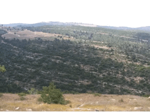
al-Walaja stood on a large hill projecting from a mountainside north of Wadi al-Sarar, through which the Jerusalem–Jaffa railway passed.
The village lay approximately 8.5 kilometres southwest of Jerusalem at an average elevation of about 750 metres above sea level.
A secondary road connected the village with the main road leading to Jerusalem.
Walid Khalidi suggests that the name al-Walaja derives from the Arabic root meaning “to enter,” possibly referring to the natural passage between the mountains through which transport routes entered.
The village obtained water from several groups of springs as well as numerous wells, particularly in the southern parts of its lands.
al-Walaja Through History
In 1596, al-Walaja was a village in the nahiya of Jerusalem in the Jerusalem district, with an estimated population of approximately 655.
The inhabitants paid taxes on wheat, barley, olives, fruit, vineyards, goats, beehives, and other forms of production.
By the mid-nineteenth century, al-Walaja was associated with the influential Darwish family, which exercised considerable power in the Bani Hasan region.
The village suffered damage in 1853 during a local conflict between the Darwish and Lahham families.
In the late nineteenth century, al-Walaja was described as a substantial stone-built village situated in a cleft on a hillside, whose inhabitants cultivated vegetables, grapes, and olives.
Architecture
The houses of al-Walaja were built of stone, adobe, and cement and clustered closely together along narrow, winding alleys.
During the final years of the British Mandate, the village expanded significantly, with new houses built northeast and southeast of its original centre.
The built-up area covered approximately 31 dunams in the 1944/1945 statistics.
The village contained several shops, while nearby quarries supplied the distinctive building stone widely used in the Jerusalem region.
The Mosque and Education
The inhabitants of al-Walaja were Muslims, and the village mosque was known as Masjid al-Arba'in, the “Mosque of the Forty.”
The village also had an elementary boys' school during the British Mandate.
Local accounts provide older traditions concerning religious education in the mosque and village kuttab, but the principal reference sources reviewed do not provide sufficient documentation to establish all of these details and dates conclusively.
Population
al-Walaja had 910 inhabitants in the 1922 census.
By the 1931 census, the population had increased to 1,206 people living in 202 houses.
According to the 1944/1945 statistics, the population reached 1,650, all Arabs.
The estimates of approximately 1,914 inhabitants for 1948 and 11,754 refugees and descendants in 1998 are later demographic estimates rather than official British Mandate censuses.
Population of al-Walaja
- 1596About 655Historical estimate based on Ottoman records
- 1922910Official census
- 19311,206Official census
- 1944/19451,650Government of Palestine statistics
- 1948About 1,914Later estimate
- 199811,754Estimate of refugees and their descendants
Number of Houses
The 1931 census recorded 202 houses in al-Walaja.
The estimate of approximately 320 houses for 1948 is a later figure rather than an official census count.
Land of al-Walaja
According to the 1944/1945 statistics, al-Walaja had a total land area of 17,708 dunams.
Arab ownership amounted to 17,507 dunams, Jewish ownership to 35 dunams, while 166 dunams were classified as public land.
The 166 dunams of public land should not all be described as roads; the official statistics classify them as public land without assigning the entire category exclusively to roads.
Land Ownership in al-Walaja in 1944/1945
- Arab ownership17,507 dunums99%
- Jewish ownership35 dunums<1%
- Public land166 dunums<1%
Agriculture and Economic Life
The inhabitants of al-Walaja practised both rain-fed and irrigated agriculture. Numerous wells and springs supplied water for orchards and fruit trees.
Cereals were cultivated mainly in the lower and flatter areas, while fruit trees, vineyards, and olives grew on the slopes.
Olive cultivation was among the village's most important agricultural activities.
According to the 1944/1945 statistics, cereal cultivation covered 6,227 dunams in total, including 6,205 Arab-owned dunams and 22 Jewish-owned dunams.
Irrigated and plantation land covered 2,136 dunams, all Arab-owned.
Palestine Remembered records approximately 80 dunams planted with olive trees. This represents a crop category within cultivated land and should not be added separately to the overall land-use totals.
Land Use in al-Walaja in 1944/1945, in Dunams
- Arab
- Jewish
- Public
- Cereals6,227 dunums
- Irrigated and plantation land2,136 dunums
- Built-up area31 dunums
- Uncultivable land9,314 dunums
Archaeology and Natural Heritage
The lands of al-Walaja contain several archaeological sites and ruins, including the Khallat al-Samak area, together with agricultural terraces, springs, caves, and remains of older structures.
al-Badawi Olive Tree
The area of the rebuilt al-Walaja contains an ancient olive tree known as the al-Badawi tree, one of the village's best-known natural and cultural landmarks.
Published estimates of its age vary considerably, ranging from approximately 3,000 to 5,000 years, while a study published by the Institute for Palestine Studies cites expert estimates of around 4,000–5,000 years.
It is therefore inappropriate to present a precise age such as 3,500 years as scientifically settled. What can safely be stated is that the al-Badawi tree is exceptionally ancient and holds considerable cultural significance for the people of al-Walaja.
Local claims that some remains in the village represent Roman baths also require more specific archaeological documentation before they can be conclusively dated to the Roman period.
Operation ha-Har
Operation ha-Har was carried out between 19 and 24 October 1948 after the second truce. Its objective was to widen the Israeli-held corridor toward Jerusalem and link it with areas occupied in the Hebron hills.
The Harel, Etziyyoni, and Giv'ati brigades participated in the operation as a whole, while Egyptian and Palestinian forces were among the principal defenders in the sector.
al-Walaja was one of the villages affected by the operation.
The October 1948 Assault on al-Walaja
The Eighth Battalion of the Etziyyoni Brigade attacked al-Walaja during Operation ha-Har. Walid Khalidi and PalQuest state that the force entered the village on the night of 21 October 1948.
Egyptian irregulars were operating in the area alongside Palestinian fighters, and intense fighting took place southwest of Jerusalem.
The Israeli occupation at this stage was not permanent. A successful Arab counterattack forced the Israeli force out of the village.
Accordingly, 21 October 1948 represents a temporary military capture during Operation ha-Har rather than the date on which the village finally passed into Israeli control.
Israeli military information is cited here only as transmitted through Walid Khalidi and PalQuest and not through direct reliance on the original Israeli sources.
The Armistice Agreement and Final Control of the Original Village Site
After the October fighting, al-Walaja remained outside permanent Israeli control for a period.
On 3 April 1949, Israel and Jordan signed their armistice agreement. The resulting armistice arrangements placed the original al-Walaja village site and extensive areas of its land on the Israeli side of the line.
Israeli forces entered the old village site during the weeks following the agreement.
The final loss of the original al-Walaja site should therefore be associated with the 1949 armistice arrangements rather than solely with the temporary October 1948 occupation.
Occupation and Depopulation Chronology
- 18–19 October 1948
Beginning of the military operation
The Harel and Etzioni brigades launched Operation ha-Har on the night of 18–19 October with an attack on Egyptian forces west of Dayr Aban, aiming to widen the corridor to Jerusalem and link it with territory occupied in the Hebron hills; al-Walaja was among the villages affected by the operation.
- Night of 21 October 1948
Ground assault and temporary occupation
According to Khalidi, the Eighth Battalion of the Etzioni Brigade attacked and captured the village, whose defenders were Egyptian irregulars fighting alongside Palestinian guerrillas. An Associated Press report dated 20 October, however, stated that fighting southwest of Jerusalem had been going on for five days and had begun with a full-scale Israeli attack on al-Walaja and Sharafat; the available sources do not reconcile the two dates.
- October 1948
Attacking force driven out by an Arab counterattack
The occupation of the village did not last: a New York Times report dated 20 October stated that the Israelis were driven out by successful Arab counterattacks, and the History of the War of Independence corroborates this. The sources give no day for the Israeli force's departure, and the report's date precedes the 21 October date that Khalidi gives for the capture.
- 3 April 1949
Handover of the village under the armistice agreement
According to the History of the War of Independence, as cited by Khalidi, the village was later handed over to Israel under the terms of the armistice agreement signed with Jordan on this date.
- Weeks after 3 April 1949
Final occupation
The Israeli army entered the village, together with three other villages in the Jerusalem area, Bayt Safafa, Battir and al-Qabu, in the weeks following the signing of the agreement.
- 1950
Settlement on village lands
The settlement of 'Amminadav was established on village lands.
Displacement and the Rebuilt al-Walaja
The transfer of the original village site to the Israeli side of the armistice line displaced its inhabitants and prevented them from returning to their original homes.
Not all villagers moved to refugee camps. Some settled on agricultural and grazing lands belonging to al-Walaja on the opposite hill, which remained on the Jordanian side of the armistice line.
Initially, many lived in temporary shelters in the expectation that they would soon return to the old village. Over time, this settlement developed into what became known as the rebuilt or new al-Walaja.
Other inhabitants became refugees in Dheisheh camp near Bethlehem, Shu'fat camp in Jerusalem, and other locations in Palestine and abroad.
The Palestinian community of al-Walaja therefore survived the Nakba, although it was separated from the historic village centre and from much of its land.
Israeli Settlements on the Lands of al-Walaja
Aminadav
Walid Khalidi and PalQuest record the establishment of Aminadav on al-Walaja's lands in 1950.
Ora
A study published by the Institute for Palestine Studies also identifies Ora, together with Aminadav, as having been established on lands lost by the people of al-Walaja following the armistice.
- 1950Aminadav
Recorded by PalQuest and Walid Khalidi as established on al-Walaja's lands
- About 1950Ora
Associated by an Institute for Palestine Studies study with lands lost by al-Walaja after the armistice
The Original Village Site After the Nakba
According to the field documentation relied upon by Walid Khalidi, several stone houses remained at the original al-Walaja village site, while extensive stone rubble covered other parts of it.
Almond trees grew on the terraces west and north of the site.
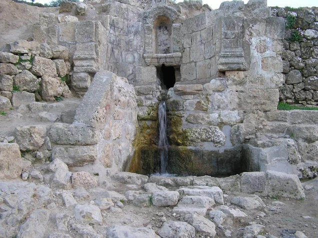
Water continued to flow from a stone-and-concrete structure built over a spring in a valley west of the village site.
The armistice line crossed the southern parts of al-Walaja's historical lands, while UNRWA established refugee shelters and an elementary school on land that remained within the West Bank.
An Institute for Palestine Studies study records that surviving remains of the original village underwent further demolition in the years after the Nakba.
Part of the old village site later came to be used for recreation, while Canada Park lies to its north.
This description reflects the condition of the site during the field documentation relied upon by Walid Khalidi and should not necessarily be interpreted as a comprehensive survey updated to 2026.
Sources
- PalQuest – Interactive Encyclopedia of the Palestine Question: al-Walaja.
- PalQuest: Operation ha-Har.
- Institute for Palestine Studies, “In the Seam Zone: Walaja's Fate Between Jerusalem and Nowhere.”
- Palestine Remembered: al-Walaja, Jerusalem District.
- Walid Khalidi, All That Remains, entry on al-Walaja.
- Government of Palestine, censuses of 1922 and 1931.
- Government of Palestine, Department of Statistics, Village Statistics, 1945.
Photo gallery


Photos from the village's people
Photos sent in by visitors and published after review.
Add a photo of this village
Log in to add photos of this village.
More from the archive
 Al-Quds (Jerusalem)
The depopulated village of Khirbat al-Tannur - Allar al-Sifla / District of Al-Quds (Jerusalem)
 Al-Quds (Jerusalem)
The depopulated village of Jarash / District of Al-Quds (Jerusalem)
 Al-Quds (Jerusalem)
The depopulated village of al-Burayj (Bayarat Burayj) / District of Al-Quds (Jerusalem)
 Download Our Palestine App
The whole archive in the palm of your hand: depopulated villages, the Nakba, the massacres and Al-Aqsa — free, with no ads to erase the story.
Download Our Palestine App
The whole archive in the palm of your hand: depopulated villages, the Nakba, the massacres and Al-Aqsa — free, with no ads to erase the story.



Comments
No comments yet — be the first to write one.
Add your comment
Name and email are optional. Comments appear after review.