
The depopulated village of Qalunya / District of Al-Quds (Jerusalem)
About the depopulated village of Qalunya
- District
- Al-Quds (Jerusalem)
- Date Qalunya was occupied
- 11 April 1948
- Population in 1948
- 1,056
- Military operation
- Operation Nachshon
- Brigade that carried it out
- Palmach
- Distance from the governorate centre
- 6 km from Jerusalem
- Elevation above sea level
- 650 m
- Cause of displacement
- Direct military assault by Zionist forces and the blowing up of the houses; accounts differ: flight after a Palmach raid on 2 or 3 April 1948 (Morris), flight after the Deir Yasin massacre (Irgun broadcast), or evacuation before the destruction (New York Times)
- Extent of destruction
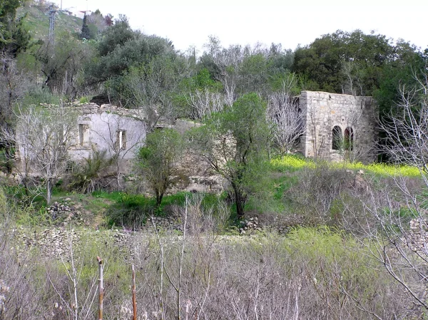
- The village was mostly destroyed with the exception of few deserted houses and the cemetery. One of the houses has been renovated and used by an Israeli Jewish settler.
- Ethnic cleansing
- Qalunya was mostly emptied of its inhabitants because of nearby fighting on April 2nd, 1948, and upon occupatio it was completely cleansed.
- Settlements built on the built-up area of Qalunya after 1948
- Mevasseret Yerushalayim, established in 1956 on village lands, later joined with Ma'oz Tziyyon (1951, on the lands of al-Qastal) to form the suburb of Mevasseret Tziyyon, largely on village lands; Motza Tachtit and Motza 'Illit are close to, but not on, the village lands
Hover a dot to read the village name, or click to open its card.
Borders of the depopulated village of Qalunya
Qalunya: A Depopulated Palestinian Village in the Jerusalem District
Qalunya was a Palestinian village in the Jerusalem District, situated on a mountain slope approximately 6 kilometres west of Jerusalem at an average elevation of about 650 metres above sea level. It stood along the Jerusalem–Jaffa road and had an Arab population of 910 in the 1944/1945 statistics. Palmach forces attacked the village on 11 April 1948 during Operation Nachshon, after which its inhabitants were displaced and most of its built environment was destroyed during the Nakba and the occupation of Palestine in 1948.
- Subdistrict
- Jerusalem
- Distance from district center
- 6 km from Jerusalem
- Average Elevation
- 650 m above sea level
- Population in 1931
- 632
- Number of Houses in 1931
- 156
- Population in 1944/1945
- 910 Arabs (900 Muslims and 10 Christians) – the 1944/45 statistics also record 350 Jews in the village's statistical unit, which includes Motza, for a total of 1,260
- Estimated Population in 1948
- About 1,056 – a later demographic estimate, not an official census
- Total Land Area in 1945
- 4,844 dunams – includes Motza; 3,594 dunams of it in Arab ownership
- Attack and Depopulation
- Qalunya was one of the main targets of Operation Nachshon; Palmach forces attacked and occupied it on 11 April 1948, and the occupying units spent two days blowing up its houses and razing them to the ground. Accounts of the depopulation differ: Benny Morris, as cited by Khalidi, claims that the inhabitants fled on 2 or 3 April as a result of a Palmach raid, an Irgun broadcast stated that they fled because of the Deir Yasin massacre, and the New York Times correspondent wrote that most had been evacuated and the rest were ordered out before the village was destroyed.
- Final Israeli Control
- 11 April 1948, when Palmach and Haganah units occupied it during Operation Nachshon, according to the History of the Haganah and the New York Times as cited by Khalidi
- Military Operation
- Operation Nachshon
- Military Unit
- The Palmach, according to the History of the Haganah, described by the New York Times as Haganah units; the available sources name no specific battalion or brigade
- Cause of Depopulation
- Direct military assault by Zionist forces and the blowing up of the village's houses; accounts of the depopulation differ between flight after a Palmach raid on 2 or 3 April 1948 (Morris), flight because of the Deir Yasin massacre (Irgun broadcast), and evacuation and orders to leave before the village was destroyed (New York Times)
- Settlements Documented on Village Lands
- Mevasseret Yerushalayim, established in 1956 on village lands, later joined with Ma'oz Tziyyon (1951, on the lands of al-Qastal) to form the suburb of Mevasseret Tziyyon, largely on village lands; Motza Tachtit and Motza 'Illit are close to, but not on, the village lands
Location
Qalunya stood on a mountain slope facing southwest, approximately 6 kilometres west of Jerusalem and at an average elevation of about 650 metres above sea level.
Wadi Qalunya ran along the village's eastern edge, while the Jerusalem–Jaffa highway passed nearby. Dirt roads connected Qalunya with neighbouring Palestinian villages.
Its position on the main road to Jerusalem and the springs in the surrounding valley gave the village both geographical and agricultural importance.
Qalunya Through History
Qalunya has traditionally been identified with the ancient site of Mozah, or Motsa, mentioned in early historical sources.
After 71 CE, the Roman emperor Vespasian settled approximately 800 veteran soldiers in the area, and the settlement became known as Colonia Amosa or Colonia Emmaus.
The later name Qalunya developed from the Latin word “colonia,” meaning colony or settlement.
Similar forms of the name continued through the Byzantine and Crusader periods. Mujir al-Din al-Hanbali also referred to Qalunya in connection with events in 1192.
In 1596, Qalunya was a village in the nahiya of Jerusalem in the Jerusalem district, with an estimated population of approximately 110.
The inhabitants paid taxes on wheat, barley, olives, goats, beehives, carob molasses, and other forms of production.
In the late nineteenth century, Qalunya was described as a medium-sized village on a hillside approximately 300 feet above the valley, with citrus trees cultivated around a spring.
Jewish Landholdings and Motza Before the Nakba
According to Walid Khalidi and PalQuest, Jewish immigrants began acquiring agricultural land associated with the Qalunya statistical area in 1859.
The small settlement of Motza was later established near Qalunya on land purchased during the nineteenth century.
Following the events of 1929, Motza was rebuilt as Motza Tahtit in 1930, while Motza 'Illit was established nearby in 1933.
Walid Khalidi and PalQuest emphasize that these settlements were adjacent to Qalunya's village lands rather than settlements established directly over the Palestinian village site after its depopulation.
Architecture and Public Facilities
Qalunya had an approximately circular layout. Most houses were built of stone and separated by winding alleys that divided the village into several quarters.
During the final years of the British Mandate, construction expanded first toward the northwest and later southward along the Jerusalem–Jaffa highway.
The village mosque, known as the Mosque of Shaykh Hamad, stood on the eastern side of the village.
Qalunya also contained several shops and an elementary school.
The Arab built-up area covered approximately 78 dunams in the 1944/1945 statistics. The wider statistical unit, which included Motza, also recorded 149 dunams of Jewish-owned built-up land.
Social and Cultural Life
Local oral histories from Qalunya describe an active social, cultural, and labour life during the final years of the British Mandate. They recall that some village workers participated in the Palestinian labour movement and that a local committee represented village families in community affairs.
These accounts also mention licensed midwives, local bone-setters, a health worker from the village, and youth involvement in sporting and cultural activities.
Oral-history material records the establishment of a sporting and cultural club known as the National Club, which organized athletic and theatrical activities.
These details derive primarily from local Palestinian documentation and oral history and are not all documented to the same degree in the principal reference works of Walid Khalidi and PalQuest.
Population
Qalunya had 549 inhabitants in the 1922 census.
By the 1931 census, the population had increased to 632 people living in 156 houses.
The 1944/1945 figures require a distinction between the Palestinian village population and the broader statistical unit that included Motza.
The Arab population was 910, consisting of 900 Muslims and 10 Christians. The statistics also recorded 350 Jews in Motza, bringing the total population of the statistical unit to 1,260.
The figure of approximately 1,056 for 1948 published by Palestine Remembered is a later estimate. The way the same table associates 350 Jewish inhabitants with that estimate is unclear, and it should therefore not be treated as an official census figure for Qalunya.
The same source estimated the number of refugees and their descendants at 6,483 in 1998.
Population of Qalunya
- 1596About 110Historical estimate based on Ottoman records
- 1922549Official census
- 1931632Official census
- 1944/1945910 Arabs900 Muslims and 10 Christians in the Palestinian village
- 1944/19451,260Statistical unit total: 910 Arabs + 350 Jews in Motza
- 1948About 1,056Later published estimate; not an official census
- 19986,483Estimate of refugees and their descendants
Number of Houses
The 1931 census recorded 156 houses in Qalunya.
The figure of approximately 260 houses for 1948 is a later estimate rather than an official census count.
Land Ownership
The Qalunya–Motza statistical unit covered a total of 4,844 dunams in the 1944/1945 statistics.
Arab ownership amounted to 3,594 dunams, Jewish ownership to 1,084 dunams, while 166 dunams were classified as public land.
These figures include Motza and should therefore not all be interpreted as referring solely to the Palestinian village's built-up area.
Land Ownership in the Qalunya–Motza Statistical Unit, 1944/1945
- Arab ownership3,594 dunums74%
- Jewish ownership1,084 dunums22%
- Public land166 dunums3%
Agriculture and Economic Life
The villagers practised both rain-fed and irrigated agriculture and used springs around the village to irrigate orchards.
Crops included cereals, vegetables, citrus fruits, other fruit trees, olives, and grape vines.
According to the 1944/1945 statistics, 846 dunams of Arab-owned land were devoted to cereals and 1,022 dunams were irrigated or used for plantations.
Approximately 200 dunams were planted with olive trees. This was a crop category within cultivated land and should not be added separately to the overall land-use total.
Because the official statistical unit included Motza, it also recorded 109 dunams of Jewish-owned cereal land and 202 dunams of Jewish-owned irrigated or plantation land.
Land Use in the Qalunya–Motza Statistical Unit in 1944/1945, in Dunams
- Arab
- Jewish
- Public
- Cereals955 dunums
- Irrigated and plantation land1,224 dunums
- Built-up area227 dunums
- Uncultivable land2,438 dunums
Archaeology
The Qalunya site contained the remains of an arched structure and other architectural remains.
Two khirbas north of the village contained foundations of old buildings and caves carved into the rock.
Local Palestinian accounts identify Khirbat Bayt Mazza and Khirbat Bayt Talma among the archaeological sites surrounding the village.
Operation Nachshon
Operation Nachshon began on 3 April 1948 and continued until 15 April. It was launched within the framework of Plan Dalet to seize villages and strategic positions along the route from the Khulda area toward Jerusalem and to secure the road leading to the city.
PalQuest lists the Harel and Giv'ati Brigades among the Zionist units participating in the operation, together with Palmach and Haganah forces mobilized for the offensive.
Qalunya was one of the principal targets of the operation.
Attacks and the Displacement of the Population
The sources differ over the precise sequence in which the inhabitants of Qalunya left their village.
PalQuest and Walid Khalidi transmit an Israeli account claiming that some villagers left on 2–3 April 1948 following a Palmach raid.
An Irgun radio broadcast, however, linked the departure of Qalunya's inhabitants to fear following the Deir Yasin massacre of 9 April.
A contemporary New York Times correspondent reported that most inhabitants had already been evacuated and that those who remained were ordered to leave before the village was destroyed.
Qalunya's displacement therefore cannot be reduced to a single cause. It occurred amid military attacks, growing fear after the Deir Yasin massacre, and the forced removal of those who remained.
Israeli accounts are cited here only as transmitted through Walid Khalidi and PalQuest and not through direct reliance on Israeli sources.
The Occupation and Destruction of Qalunya
Palmach forces attacked Qalunya on 11 April 1948, when the village was one of the principal targets of Operation Nachshon.
The detailed account transmitted by Walid Khalidi and PalQuest states that the attacking forces entered the village and began demolishing its buildings, with systematic destruction continuing for approximately two days.
A contemporary press report likewise stated that Haganah forces blew up numerous houses and left much of the village burning.
An eyewitness who accompanied the Palmach force described an exchange of fire during the assault and the subsequent demolition of stone houses, as well as fatalities during the fighting.
The principal Palestinian sources reviewed do not identify a specific Palmach battalion as conclusively responsible for the Qalunya assault. This article therefore does not assign the attack to a particular battalion without further evidence.
The Palestine Remembered summary table gives 3 April and attributes the operation to Irgun, but this conflicts with the site's own detailed Walid Khalidi account and with PalQuest. This article therefore uses 11 April 1948 and Palmach forces as the better documented description.
Occupation and Depopulation Chronology
- 2 or 3 April 1948, or after 9 April 1948
Beginning of the exodus
Accounts differ: Benny Morris, as cited by Khalidi, claims that the inhabitants fled on 2 or 3 April as a result of a Palmach raid, while an Irgun broadcast stated at the time that they fled because of the Deir Yasin massacre of 9 April. The New York Times correspondent wrote that most inhabitants had been evacuated and that the rest were ordered out before the village was destroyed.
- 3 April 1948
Beginning of the military operation
Operation Nachshon, for which a force of 1,500 Palmach and Haganah troops was mobilized to overrun the villages on both sides of the Tel Aviv–Jerusalem road within the framework of Plan Dalet, began with the occupation of Dayr Muhaysin and Khulda; Qalunya was one of its main targets.
- 11 April 1948
Ground assault and occupation of the village
Palmach forces attacked the village, according to the History of the Haganah, and the New York Times reported that Haganah units occupied it on this day. Harry Levin, who accompanied the Palmach force during the assault, counted fourteen dead, “but there were more.”
- From 11 April 1948, over two days
Destruction of the village
According to Benny Morris and Haganah reports, as cited by Khalidi, the occupying units spent two days blowing up the houses and razing them to the ground; the New York Times reported that they blew up a score of houses and left the entire village ablaze.
- 1956
Settlement on village lands
The settlement of Mevasseret Yerushalayim was established on village lands; it was later joined with Ma'oz Tziyyon (1951, on the lands of al-Qastal) to form the suburb of Mevasseret Tziyyon, largely on village lands.
Israeli Settlements on Qalunya's Lands
Mevasseret Yerushalayim
Mevasseret Yerushalayim was established in 1956 on Qalunya's lands.
It was later merged with Ma'oz Tziyyon, established in 1951 on the lands of the Palestinian village of al-Qastal, to form the present locality known as Mevasseret Tziyyon.
The combined locality lies northwest of the Qalunya village site, with a substantial part situated on Qalunya's lands.
Motza
Motza Tahtit and Motza 'Illit existed near Qalunya before the Nakba. According to Walid Khalidi and PalQuest, they were adjacent to Qalunya's lands rather than post-1948 settlements established directly on the Palestinian village lands.
Qalunya After the Nakba
According to the field documentation relied upon by Walid Khalidi, only a few houses remained in the southwestern section of the village site near the cemetery.
Some surviving houses had arched doors and windows, and one was being used as a residence at the time of documentation.
Stone rubble, fragments of collapsed cement roofs, and iron window frames were scattered across the site.
An old Jewish building dating to 1871 also remained near the site.
The village's agricultural terraces survived, with almond, fig, olive trees, and cactus plants growing on them and along the lower slopes.
This description reflects the condition of the site during the field documentation relied upon by Walid Khalidi and should not necessarily be interpreted as a comprehensive survey updated to 2026.
Sources
- PalQuest – Interactive Encyclopedia of the Palestine Question: Qalunya.
- PalQuest: Qalunya.
- PalQuest: Operation Nachshon.
- Palestine Remembered: Qalunya, Jerusalem District.
- Walid Khalidi, All That Remains, entry on Qalunya.
- Government of Palestine, censuses of 1922 and 1931.
- Government of Palestine, Department of Statistics, Village Statistics, 1945.
Photo gallery


Photos from the village's people
Photos sent in by visitors and published after review.
Add a photo of this village
Log in to add photos of this village.
Other villages from Al-Quds (Jerusalem)
More from the archive
 Al-Quds (Jerusalem)
The depopulated village of Khirbat al-Tannur - Allar al-Sifla / District of Al-Quds (Jerusalem)
 Al-Quds (Jerusalem)
The depopulated village of Jarash / District of Al-Quds (Jerusalem)
 Al-Quds (Jerusalem)
The depopulated village of al-Burayj (Bayarat Burayj) / District of Al-Quds (Jerusalem)
 Download Our Palestine App
The whole archive in the palm of your hand: depopulated villages, the Nakba, the massacres and Al-Aqsa — free, with no ads to erase the story.
Download Our Palestine App
The whole archive in the palm of your hand: depopulated villages, the Nakba, the massacres and Al-Aqsa — free, with no ads to erase the story.



Comments
No comments yet — be the first to write one.
Add your comment
Name and email are optional. Comments appear after review.