
The depopulated village of Saris / District of Al-Quds (Jerusalem)
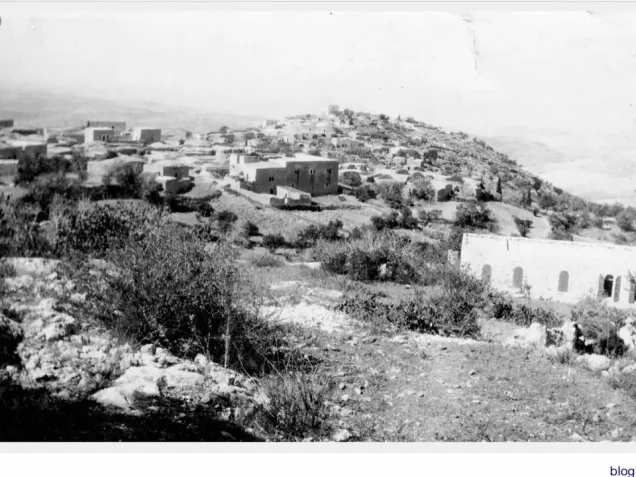
About the depopulated village of Saris
- District
- Al-Quds (Jerusalem)
- Date Saris was occupied
- 16 April 1948
- Population in 1948
- 650
- Military operation
- Operation Nachshon
- Brigade that carried it out
- A Haganah task force of about 500 troops (called 'the battalion' in a Haganah statement); the sources do not identify its brigade
- Who defended the village
- Local militia & Arab Liberation Army
- Distance from the governorate centre
- 15 km west of Jerusalem
- Elevation above sea level
- 675 m
- Cause of displacement
- Direct military assault by Zionist forces, and the fear spread by the Deir Yasin massacre (9 April 1948), according to an official British dispatch quoted by Morris as cited by Khalidi
- Extent of destruction
- Saris was completely defaced with the exception of its cemetery.
- Ethnic cleansing
- Saris' population fled under the influence of the Dayr Yasin's massacre committed on the 9th of April, 1948.
- Settlements built on the built-up area of Saris after 1948
- Shoresh, established in 1948 1 km southwest of the village site; and Sho'eva, established in 1950 0.5 km northeast of the site; both on village land
Hover a dot to read the village name, or click to open its card.
Borders of the depopulated village of Saris
Saris: A Depopulated Palestinian Village in the Jerusalem District
Saris was a depopulated Palestinian village in the Jerusalem District, located approximately 15 kilometers west of Jerusalem on a high ridge running north to south, at an average elevation of about 675 meters above sea level.
- Subdistrict
- Jerusalem
- Distance from district center
- 15 km west of Jerusalem
- Average Elevation
- 675 m above sea level
- Population in 1931
- 470
- Number of Houses in 1931
- 114
- Population in 1944/1945
- 560
- Estimated Population in 1948
- About 650 – a later demographic estimate, not an official census
- Total Land Area in 1945
- 10,699 dunams
- Attack and Depopulation
- A Haganah task force of about 500 troops attacked the village in mid-April 1948, towards the end of Operation Nachshon (on 13 April according to the History of the Haganah, on 16 April according to other sources), destroying 25 houses as well as the village mosque and a school, according to the New York Times (35 houses according to 'Arif al-'Arif), and killing 7 Arabs before withdrawing. An official British dispatch quoted by Morris implies that the inhabitants fled under the influence of the Deir Yasin massacre.
- Final Israeli Control
- The sources give no date of final Israeli control: although the History of the Haganah dates the capture of the village to 13 April 1948 (other sources date the attack to 16 April), Khalidi concludes that the Haganah did not hold it firmly and that it remained on the front lines, since the Arab Liberation Army recorded an attack on Bayt Mahsir on 9 May 1948 that 'failed at the village of Saris'
- Military Operation
- Operation Nachshon
- Military Unit
- A Haganah task force of about 500 troops (called 'the battalion' in a Haganah statement); the sources do not identify its brigade
- Cause of Depopulation
- Direct military assault by Zionist forces, and the fear spread by the Deir Yasin massacre (9 April 1948), according to an official British dispatch quoted by Morris as cited by Khalidi
- Settlements Documented on Village Lands
- Shoresh, established in 1948 1 km southwest of the village site; and Sho'eva, established in 1950 0.5 km northeast of the site; both on village land
The village overlooked the Jerusalem–Jaffa highway and extensive areas in every direction. Ramla and Lydda could be seen from its western side. During the Nakba and the occupation of Palestine in 1948, Saris was subjected to a major assault in mid-April toward the end of Operation Nachshon. A substantial part of the village was destroyed, although the available evidence indicates that permanent military control of the site was not established immediately after the attack.
Location of Saris
- Saris was located approximately 15 kilometers west of Jerusalem.
- Its average elevation was about 675 meters above sea level.
- The village stood on a high ridge extending from north to south and descending sharply at its northern end.
- It overlooked the Jerusalem–Jaffa highway to the north.
- Its elevated position provided extensive views, including toward Ramla and Lydda in the west.
- Woodlands surrounding the site contributed to its mountainous landscape.
Saris Through History
In 1596, Saris was a village in the nahiya of Jerusalem within the liwa' of Jerusalem and had an estimated population of approximately 292 according to Ottoman records cited by Walid Khalidi.
The inhabitants paid taxes on wheat, barley, olives, fruit, and carob, as well as goats, beehives, and vineyards.
By the late nineteenth century, Saris was described as a village situated on top of a hill, with olive trees growing below it.
The Built Environment of Saris
The village had an arc-shaped or crescent-shaped layout that followed the contours of the hill, and most of its houses were constructed of stone.
All of its inhabitants were Muslims. A mosque and several shops stood in the village center, while springs and wells supplied water for domestic use.
The built-up area covered approximately 10 dunums according to the 1944/1945 statistics.
Population of Saris
The 1922 census recorded 373 inhabitants in Saris, all Muslims. In the 1931 census, the population increased to 470 people living in 114 houses.
The Government of Palestine's 1944/1945 statistics recorded 560 inhabitants, all Arab Muslims.
The figures of 650 inhabitants for 1948 and 3,989 refugees for 1998 published by Palestine Remembered are later estimates rather than official Government of Palestine censuses.
Population of Saris
- 1596292Historical estimate based on Ottoman records
- 1922373Official census under the British Mandate
- 1931470Official census under the British Mandate
- 1944/1945560Government of Palestine statistics
- 1948650Later estimate published by Palestine Remembered
- 19983,989Later refugee-population estimate published by Palestine Remembered
Number of Houses in Saris
The 1931 census recorded 114 houses in Saris. The figure of 157 houses for 1948 published by Palestine Remembered is a later estimate rather than an official Government of Palestine census figure.
Number of Houses in Saris
- 1931114Official census
- 1948157Estimate published by Palestine Remembered
Land Ownership in Saris
The total land area recorded for Saris in the 1944/1945 statistics was 10,699 dunums.
The Arabic Palestine Remembered table uses the categories “Palestinian,” “Transferred to Zionists,” and “Masha'.” These terms are preserved below to reflect the terminology of that source. The Government of Palestine statistics use the official categories “Arab,” “Jewish,” and “Public.”
Land Ownership in Saris, 1944/1945, Using the Terminology of Palestine Remembered
- Palestinian10,427 dunums97%
- Transferred to Zionists132 dunums1%
- Masha' (source terminology)140 dunums1%
Land Use in Saris in 1944/1945
A total of 4,196 dunums was cultivated or classified as cultivable land, consisting of 4,043 dunums of Arab land, 123 dunums of Jewish land, and 30 dunums of public land.
Cereals covered 3,830 dunums: 3,677 dunums of Arab land, 123 dunums of Jewish land, and 30 dunums of public land. Plantations and irrigable land covered another 366 dunums, all of it Arab land.
Non-cultivable land totaled 6,493 dunums, consisting of 6,374 dunums of Arab land, 9 dunums of Jewish land, and 110 dunums of public land. The built-up area covered another 10 dunums.
Land Use in Saris According to the 1944/1945 Statistics
- Arab
- Jewish
- Public
- Cereals3,830 dunums
- Plantations and Irrigable Land366 dunums
- Built-up Area10 dunums
- Non-Cultivable Land6,493 dunums
Palestine Remembered separately records approximately 415 dunums planted with olive trees. This figure does not appear as an independent additive category in the official land-use table above and is therefore presented as supplementary agricultural information rather than added again to the total.
Economic Life in Saris
Agriculture formed the principal basis of the village economy. The inhabitants cultivated cereals, olives, fruit, and other crops and made use of the surrounding mountainous lands.
Olive trees were among the most prominent crops and grew particularly on the slopes below the village.
The inhabitants relied on springs and wells for domestic water, while much of the agriculture was rainfed.
The Mosque and Education in Saris
A mosque and several shops stood in the center of Saris. Palestine Remembered also records a boys' school in the village.
Contemporary reports cited by Walid Khalidi state that both the mosque and the school were among the buildings destroyed during the April 1948 assault.
Archaeological and Older Sites Around Saris
Walid Khalidi records several khirbas within the lands of Saris, indicating an older history of human settlement in the surrounding area.
Palestinian local sources provide names for a number of these sites, but the lists differ between sources. They are therefore not presented here as a definitive archaeological inventory.
Operation Nachshon
Saris was attacked and extensively demolished toward the end of Operation Nachshon, a Zionist military offensive that officially lasted from 3 to 15 April 1948 within the framework of Plan Dalet.
The operation was intended to seize villages and strategic positions along the Tel Aviv–Jerusalem route and open a corridor for military forces and supplies toward Jerusalem. Approximately 1,500 Palmach and Haganah troops organized into three battalions were mobilized for the offensive, which broadly involved units associated with the Har'el and Giv'ati Brigades.
The principal sources used here do not identify a specific brigade as the force that attacked Saris itself. The village's capture should therefore not be attributed to either Har'el or Giv'ati without additional documentation.
The April 1948 Assault on Saris
The sources differ regarding the exact date of the principal assault on Saris. According to the History of the Haganah, as cited by Walid Khalidi, the village was taken on 13 April 1948. Other sources place the attack on 16 April.
Palestine Remembered uses 16 April as the occupation date. Because Operation Nachshon officially ended on 15 April, this second date falls one day after its formal conclusion, although Khalidi describes the destruction of Saris as occurring toward the end of the operation.
According to a contemporary New York Times report cited by Khalidi, a Haganah task force of approximately 500 troops attacked the village in the early morning with mortars and small arms.
The report stated that seven Arabs were killed and that 25 houses, along with the village mosque and school, were destroyed. Palestinian historian 'Arif al-'Arif, by contrast, recorded the destruction of 35 houses.
The newspaper also quoted a Haganah statement claiming that the attacking force remained in Saris for approximately five hours, blowing up 25 buildings and burning others before withdrawing. These military-account details are included here through the Palestinian intermediary source Khalidi/PalQuest rather than through independent reliance on Israeli sources.
Was Saris Permanently Occupied in April 1948?
The available evidence does not support the conclusion that the Haganah established firm and permanent control of Saris immediately after the destructive April assault.
On 9 May 1948, the Arab Liberation Army recorded an attack on neighboring Bayt Mahsir and stated that the assault had “failed at the village of Saris.”
Walid Khalidi therefore concludes that although Saris was extensively demolished in mid-April, the Haganah did not firmly hold the village and it subsequently remained on the front lines.
It is therefore important to distinguish between the April assault that destroyed much of Saris and caused substantial displacement, and the question of permanent military control of the site, for which the available sources do not provide one precise final date.
The Displacement of the People of Saris During the Nakba
The displacement of the inhabitants of Saris was connected both to direct military assault and to the widespread fear that followed the Dayr Yasin massacre of 9 April 1948.
Walid Khalidi, citing Benny Morris, refers to an official British dispatch indicating that the people of Saris fled under the impact of the Dayr Yasin massacre. This account is included through the Palestinian intermediary source Khalidi/PalQuest rather than through independent reliance on an Israeli source.
Palestine Remembered, meanwhile, classifies direct Zionist military assault as the cause of the village's depopulation. The most accurate formulation is therefore that the displacement resulted from the interaction of military attack and the climate of fear generated by massacres and military developments in the Jerusalem region.
Occupation and Depopulation Chronology
- 13 April 1948
Request for a settlement at Saris
Shortly before the village was taken, Haganah chief Israel Galili wrote to senior Jewish National Fund official Yosef Weitz asking for a settlement to be established at Saris 'as soon as possible', describing settlements at this and seven other sites as 'important to security', according to Morris as cited by Khalidi.
- 13 April 1948 or 16 April 1948
Ground assault and temporary occupation
The History of the Haganah reports that the village was taken on 13 April, while other sources indicate that the attack occurred on 16 April. A Haganah task force of 500 soldiers attacked it in the early morning with mortars and small arms, and a Haganah statement said that the battalion stayed in the village about five hours before withdrawing, according to the New York Times as cited by Khalidi.
- 13 April 1948 or 16 April 1948
Destruction of the village
The attacking force destroyed 25 houses as well as the village mosque and a school and killed 7 Arabs, according to the New York Times; a Haganah statement said that it blew up 25 buildings and burned others, and admitted that some women may have been among the casualties. Palestinian historian 'Arif al-'Arif states that 35 houses were demolished.
- April 1948
Depopulation of the village
An official British dispatch issued later that month, quoted by Morris as cited by Khalidi, implied that the people of Saris fled under the influence of the massacre at nearby Deir Yasin on 9 April; the Haganah statement maintained that the residents were evacuated at the beginning of the attack.
- 9 May 1948
The village remains on the front lines
The Arab Liberation Army recorded an attack on the neighbouring village of Bayt Mahsir that 'failed at the village of Saris'; Khalidi concludes that the Haganah did not hold Saris firmly after the April attack and that the village remained on the front lines.
- Date not documented in the available sources
Final occupation
The available sources do not give the date on which Israeli forces took firm control of Saris after it had remained on the front lines.
- 20 August 1948
Plan for a settlement on the village site
A plan submitted by the Jewish National Fund called for a settlement to be built on the village site, according to Morris as cited by Khalidi.
- Later in 1948
Settlement on village lands
The settlement of Shoresh was inaugurated on village land, 1 km southwest of the village site.
- 1950
Settlement on village lands
The settlement of Sho'eva was established on village land, 0.5 km northeast of the village site.
Plans to Establish a Settlement on the Lands of Saris
On 13 April 1948, shortly before the village was attacked or before control of it was consolidated, Haganah chief Israel Galili wrote to Yosef Weitz, a senior Jewish National Fund official, requesting that a settlement be established at Saris as soon as possible.
Walid Khalidi, citing Benny Morris, states that Galili considered the establishment of settlements at Saris and seven other sites important for security.
On 20 August 1948, the Jewish National Fund submitted a plan for a settlement at the site, and Shoresh was established later that year.
Settlements Established on the Lands of Saris
Two Israeli settlements were established on the lands of Saris:
- Shoresh: established in 1948 approximately one kilometer southwest of the village site, on Saris land.
- Sho'eva: established in 1950 approximately half a kilometer northeast of the site, also on village land.
The Site of Saris After the Nakba
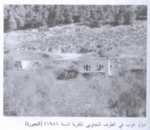
According to Walid Khalidi's field description, stone rubble covers the site of Saris, with iron bars protruding from collapsed roofs. Several open wells and caves with arched roofs also remained visible.
Cypress, fig, and almond trees grow across the site. An abandoned almond grove lies on the eastern side, while the remains of an artificial pool can be seen in the middle of the slope.
The village cemetery lies southwest of the site, surrounded by trees, and contains several large graves.
Forests were also planted on parts of the village lands after the Nakba, including one named after the settlement of Shoresh.
This description is based on fieldwork conducted for Walid Khalidi's All That Remains and should not necessarily be treated as a field survey updated to the present day.
Sources
- PalQuestPalQuest – Interactive Encyclopedia of the Palestine Question: Saris
- PalQuestPalQuest – Interactive Encyclopedia of the Palestine Question: Operation Nachshon
- Institute for Palestine StudiesInstitute for Palestine Studies: Walid Khalidi, All That Remains
- Palestine RememberedPalestine Remembered: Saris – Jerusalem District
- palqura.comPalestinian Villages Encyclopedia: Saris – Local Historical Documentation
Photo gallery


Photos from the village's people
Photos sent in by visitors and published after review.
Add a photo of this village
Log in to add photos of this village.
Other villages from Al-Quds (Jerusalem)
More from the archive
 Al-Quds (Jerusalem)
The depopulated village of Khirbat al-Tannur - Allar al-Sifla / District of Al-Quds (Jerusalem)
 Al-Quds (Jerusalem)
The depopulated village of Jarash / District of Al-Quds (Jerusalem)
 Al-Quds (Jerusalem)
The depopulated village of al-Burayj (Bayarat Burayj) / District of Al-Quds (Jerusalem)
 Download Our Palestine App
The whole archive in the palm of your hand: depopulated villages, the Nakba, the massacres and Al-Aqsa — free, with no ads to erase the story.
Download Our Palestine App
The whole archive in the palm of your hand: depopulated villages, the Nakba, the massacres and Al-Aqsa — free, with no ads to erase the story.



Comments
No comments yet — be the first to write one.
Add your comment
Name and email are optional. Comments appear after review.