
The depopulated village of Nasir al-Din / District of Tiberias

Nasir al-Din
About the depopulated village of Nasir al-Din
- District
- Tiberias
- Date Nasir al-Din was occupied
- 12 April 1948
- Population in 1948
- 100
- Elevation above sea level
- 75 m
- Cause of displacement
- Military assault by Zionist troops
- Extent of destruction
- Nasir al-Din was completely obliterated soon after occupation.
- Ethnic cleansing
- Nasir al-Din inhabitants were completely ethnically cleansed.
- Settlements built on the built-up area of Nasir al-Din after 1948
- Upper Tiberias Neighborhoods
- Refugees' migration routes
- Nasir al-Din refugees fled to Tiberias city and Lubya who were evacuated by the British troops.
Hover a dot to read the village name, or click to open its card.
Borders of the depopulated village of Nasir al-Din
Nasir al-Din (Khirbat Nasir al-Din) – Depopulated Palestinian Village of the Tiberias Subdistrict
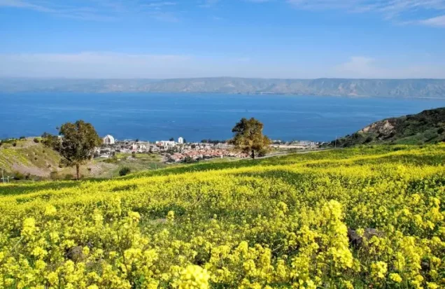
Nasir al-Din, also commonly referred to as Khirbat Nasir al-Din, was a Palestinian village in the Tiberias Subdistrict. It stood on the crest of a hill overlooking the city and Lake Tiberias, approximately 3 km southwest of Tiberias and at an average elevation of about 75 metres above sea level.
Its inhabitants were Muslims who depended primarily on agriculture and livestock raising. The village had an official population of 90 in 1944/45. On 11 or 12 April 1948, two platoons of the Golani Brigade attacked the village as part of the military pressure preceding the occupation of Tiberias. Villagers were killed, houses were destroyed or burned, and most of the population fled toward Lubya or Tiberias.
Name of Nasir al-Din
The principal sources refer to the village as Nasir al-Din, while the form Khirbat Nasir al-Din is also widely used in later Palestinian documentation.
The village was named after a figure known as Nasir al-Din, whose shrine stood north of the village site. Local tradition held that he had been killed in battle against the Crusaders and buried there. This account should be understood as local tradition rather than independently verified archaeological history.
The villagers also maintained a second shrine dedicated to Shaykh al-Qaddumi on Tall Ma'un, approximately 1 km west of the village. Local tradition similarly associated him with fighting against the Crusaders.
Location
Nasir al-Din stood on a hilltop in eastern Lower Galilee, approximately 3 km southwest of Tiberias and around 75 metres above sea level.
Its elevated position overlooked both the city of Tiberias and Lake Tiberias. A number of springs lay east, southeast, and south of the village.
A secondary road connected Nasir al-Din with a highway to the northwest leading into Tiberias. Al-Manara lay about 3 km to the southeast, while Lubya was situated farther west.
Village Layout
Nasir al-Din had no rigidly organized village plan. Its houses were generally scattered along a north–south axis.
The official 1931 census recorded 35 occupied houses. No separate, securely documented built-up area for Nasir al-Din alone is available from the 1944/45 land statistics because the village's land was tabulated jointly with al-Manara.
Population of Nasir al-Din
- 1922109Official Government of Palestine census; all inhabitants were Muslim.
- 1931179Official census; the inhabitants were Muslim.
- 1944/4590Official figure for Nasir al-Din separately.
- 1948Approx. 104Later estimate, not an official census.
Several widely reproduced population figures for Nasir al-Din are incorrect because they combine it with al-Manara. Palestine Remembered lists 230 inhabitants for 1922 and 580 for 1945. In fact, the 1922 figures were 109 for Nasir al-Din and 121 for al-Manara, while the 1944/45 figures were 90 for Nasir al-Din and 490 for al-Manara.
The same problem affects Palestine Remembered's later figures of 672 inhabitants in 1948 and 4,132 refugees in 1998. They should not be presented as estimates for Nasir al-Din alone because they were generated from an incorrectly combined population baseline.
Number of Houses
- 193135Official Government of Palestine census.
No independently documented official house count for Nasir al-Din in 1948 has been established in the principal sources reviewed.
Land Ownership of Nasir al-Din and Al-Manara
The land figures require particular caution because the Government of Palestine's 1944/45 statistics combined Nasir al-Din and al-Manara as one statistical land unit. The total of 6,797 dunums therefore does not represent Nasir al-Din alone.
Using the original official ownership categories, the combined unit was distributed as follows:
- Arab4,185 dunums62%
- Jewish1,410 dunums21%
- Public1,202 dunums18%
The published statistics do not allow these ownership categories to be reliably separated between Nasir al-Din and al-Manara. The simplified Arabic Palestine Remembered table also omits the 1,410 dunums recorded in the official Jewish category and is therefore not used here.
Land Use in 1944/45
The following figures apply to Nasir al-Din and al-Manara jointly, not to Nasir al-Din alone:
- Arab
- Jewish
- Public
- Cereals5,555 dunums
- Built-up187 dunums
- Non-Cultivable1,055 dunums
The combined statistical unit therefore contained 5,555 dunums of cultivable or cultivated land, approximately 82 percent of the total, while built-up and non-cultivable land amounted to 1,242 dunums.
Economic Life
The inhabitants of Nasir al-Din relied primarily on agriculture and livestock breeding. The joint land statistics with al-Manara underline the importance of cereal cultivation: 4,172 dunums of Arab land in the combined unit were devoted to cereals in 1944/45.
Because the official land figures combine the two villages, the cultivated area belonging specifically to the inhabitants of Nasir al-Din cannot be established accurately from the published statistics.
Water Resources
Several springs surrounded the village to the east, southeast, and south and provided water for the inhabitants and their livestock.
Later Palestinian local documentation records springs in the vicinity under names including 'Ayn al-Tina or 'Ayn al-Bathna east of the village, 'Uyun al-Biyar to the southeast, and 'Ayn al-Kalb to the south. Wadis in the area drained toward Lake Tiberias and the Wadi al-Fajjas system.
Education and Services
The principal sources reviewed do not document a formal school or significant institutional public services in Nasir al-Din before the Nakba. No school or other service institution is therefore added without documentation.
The Shrines of Nasir al-Din and Shaykh al-Qaddumi
Two local shrines were associated with the village. The shrine of Nasir al-Din stood north of the village site and gave the village its name according to local tradition. A second shrine dedicated to Shaykh al-Qaddumi stood on Tall Ma'un, approximately 1 km to the west.
Traditions connecting both figures to warfare against the Crusaders are presented as local religious and historical traditions rather than as independently established archaeological facts.
A Note on “Kefar Menori”
Some online tables incorrectly identify Nasir al-Din as occupying the site of the Roman-period locality Kefar Menori. PalQuest's entry for al-Manara, however, is the source that associates Kefar Menori with al-Manara. That identification is therefore not transferred to Nasir al-Din in this article.
The Nasir al-Din Massacre
On 11 or 12 April 1948, two platoons of the Golani Brigade based in the Jewish quarter of Tiberias advanced on Nasir al-Din. The attack formed part of the mounting military pressure on the Palestinian population around Tiberias before the city's occupation.
Sources disagree over the number of villagers killed. Palestinian historian Nafez Nazzal, drawing on eyewitness testimony, identified seven villagers killed during the assault. Palestinian historian 'Arif al-'Arif stated that ten people were killed and that the village houses were burned.
An official British communiqué reported in the Palestinian newspaper Filastin stated that eight men, one woman, and an unspecified number of children were killed. The newspaper also reported that stone houses were blown up while mud houses were set on fire.
No single casualty figure can therefore be presented as definitive. The sources nevertheless agree that villagers were killed, including women and children according to the British communiqué, and that homes were destroyed or burned during the attack.
Occupation and Depopulation
Walid Khalidi describes the assault on Nasir al-Din as part of a tactic used before the occupation of Tiberias: striking a nearby Palestinian village with exceptional force in order to spread fear among the city's population and generate a refugee flow.
Most inhabitants fled toward Lubya or Tiberias. Those who reached Tiberias were subsequently evacuated by British troops to Lubya.
The occupation of Nasir al-Din also effectively severed Tiberias from the large Palestinian village of Lubya and increased the city's isolation. The arrival of traumatized refugees from the village contributed to declining morale among the Palestinian population of Tiberias.
The account discussed by Khalidi indicates that some residents may have remained after the initial assault but were compelled to leave by 23 April 1948. The exact circumstances of this later expulsion are not clearly documented.
Military Unit and Operation
The principal village source securely identifies the Golani Brigade: two of its platoons advanced on Nasir al-Din from the Jewish quarter of Tiberias.
Khalidi's village-specific entry does not independently identify the battalion involved, so more specific battalion attributions appearing in secondary sources are not treated here as established fact.
The attack is also not assigned to a separately named military operation in the principal village entry. It belonged to the series of assaults that prepared the way for the occupation of Tiberias, which fell on 18 April 1948.
Occupation Chronology
- 11 or 12 April 1948
Main assault
Two platoons of the Golani Brigade advanced on the village. Villagers were killed and homes were destroyed or burned.
- 11–12 April 1948
Main population flight
Most inhabitants fled toward Lubya or Tiberias. British troops later transferred refugees who had reached Tiberias toward Lubya.
- 11 or 12 April 1948
Occupation of the village
The attacking force took control of Nasir al-Din, helping to sever Tiberias from Lubya and the Palestinian hinterland west of the city.
- 18 April 1948
Fall of Tiberias
Tiberias fell several days after the attack on Nasir al-Din, which had formed part of the military pressure preceding the city's occupation.
- By 23 April 1948
Removal of remaining inhabitants
According to the account discussed by Khalidi, some inhabitants remained after the initial assault but were later forced to leave. The exact circumstances remain unclear.
Israeli Urban Expansion on Nasir al-Din Lands
Khalidi does not identify a separate Israeli settlement by name as having been established on Nasir al-Din's lands. Instead, the post-1948 urban expansion of the city of Tiberias extended over the former village site and parts of its land.
It is therefore more accurate to state that residential sections of Tiberias were built on the site and part of the village lands rather than to invent or assign a separate settlement name without documentation.
Nasir al-Din Today
According to the field description published by Walid Khalidi in All That Remains, no visible sign of the former village remained. Residential buildings belonging to the city of Tiberias had been erected on parts of the village site and land.
Other portions of the former village land remained undeveloped and were being used as grazing areas.
Palestine Remembered contains later community documentation of the village site, including material uploaded in 2015. Upload dates should not automatically be treated as dates of photography, nor do these contributions constitute a comprehensive independent field survey. Khalidi's description itself derives from fieldwork conducted before the publication of All That Remains in 1992 and does not represent direct verification of conditions in 2026.
Sources
- PalQuest – Nasir al-Din
- PalQuest – Al-Manara, for the combined land and population statistics
- Palestine Remembered – Nasir al-Din, Tiberias
- Palestine Remembered – Nasir al-Din entry from Walid Khalidi's All That Remains
- Palestinian Encyclopedia – Nasir al-Din
- Institute for Palestine Studies – Walid Khalidi, All That Remains
- Government of Palestine – Report and General Abstracts of the Census of 1922
- Government of Palestine – Census of Palestine 1931
- PalQuest – Israeli Intelligence Report on the Depopulation of Palestine, 30 June 1948, published and contextualized by a Palestinian source
Photo gallery
Photos from the village's people
Photos sent in by visitors and published after review.
Add a photo of this village
Log in to add photos of this village.
Other villages from Tiberias
More from the archive


 Download Our Palestine App
The whole archive in the palm of your hand: depopulated villages, the Nakba, the massacres and Al-Aqsa — free, with no ads to erase the story.
Download Our Palestine App
The whole archive in the palm of your hand: depopulated villages, the Nakba, the massacres and Al-Aqsa — free, with no ads to erase the story.



Comments
No comments yet — be the first to write one.
Add your comment
Name and email are optional. Comments appear after review.