
The depopulated village of Al-Shajara / District of Tiberias
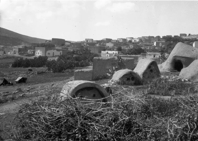
Al-Shajara
About the depopulated village of Al-Shajara
- District
- Tiberias
- Date Al-Shajara was occupied
- 06 May 1948
- Population in 1948
- 890
- Brigade that carried it out
- Golani Brigade
- Who defended the village
- Arab Liberation Army and local Palestinian militia.
- Distance from the governorate centre
- 14 (km) West of Tiberias
- Elevation above sea level
- 250 m
- Cause of displacement
- Military assault by Zionist troops
- Extent of destruction
- al-Shajara was completely obliterated, and only house rubble left behind.
- Ethnic cleansing
- al-Shajara inhabitants were completely ethnically cleansed.
- Settlements built on the built-up area of Al-Shajara after 1948
- Ilaniyya, established as Sejera in 1902, and Sde Ilan, established in 1949
Hover a dot to read the village name, or click to open its card.
Borders of the depopulated village of Al-Shajara
al-Shajara: A Depopulated Palestinian Village in the Tiberias District
al-Shajara was a Palestinian village in the Tiberias District, located about 14 kilometres west of the city of Tiberias, on the eastern slope of a moderately elevated hill, at an average elevation of approximately 250 metres above sea level. Its lands covered 3,754 dunams, making it the fourth-largest village in the Tiberias District in terms of land area. Forces from the Golani Brigade occupied the village on 6 May 1948, and its inhabitants were displaced during the Nakba and the occupation of Palestine in 1948.
- Subdistrict
- Tiberias
- Distance from district center
- 14 km West of Tiberias
- Average Elevation
- 250 meters above sea level
- Population in 1931
- 584 inhabitants - Official census
- Number of Houses in 1931
- 124 houses - Official census
- Population in 1944/1945
- 770 inhabitants - Government of Palestine statistics: 720 Muslims and 50 Christians
- Estimated Population in 1948
- About 893 inhabitants - a later demographic estimate, not an official census
- Total Land Area in 1945
- 3,754 dunams
- Attack and Depopulation
- The Attack of 17 February 1948 In mid-February 1948, while fighting was taking place in the Baysan Valley region, the Haganah launched a diversionary attack against al-Shajara. PalQuest, drawing on the Palestinian newspaper Filastin, reports that shortly after midnight on 17 February a Haganah unit infiltrated the village and blew up two houses.
- Final Israeli Control
- 6 May 1948
- Military Unit
- Golani Brigade
- Cause of Depopulation
- Military assault by Zionist troops
- Settlements Documented on Village Lands
- Ilaniyya, established as Sejera in 1902, and Sde Ilan, established in 1949
Location
al-Shajara stood on the eastern slope of a moderately elevated hill. A narrow valley ran from north to south along the village's eastern boundary.
A main road passed nearby and connected the area with Tiberias and Nazareth, giving the village an important position among the communities of Lower Galilee.
The lands of al-Shajara bordered those of Lubya, Tur'an, and other villages in the region. The Zionist settlement of Sejera stood nearby to the northeast.
Most of the village houses were concentrated in the northeastern part of the site, while some were located farther west. The hillsides to the south were covered with woodland and wild vegetation.
al-Shajara Through History
During the Crusader period, the village was known as “Seiera.”
In 1596, al-Shajara was a village in the Tiberias subdistrict of the Safad district, with an estimated population of approximately 396.
Its inhabitants paid taxes on wheat, barley, olives, fruit, goats, beehives, orchards, and a press used for processing olives or grapes.
In 1812, Swiss traveller Johann Ludwig Burckhardt noted the abundance of wild artichokes in the plain surrounding the village.
By the late nineteenth century, al-Shajara was described as a stone-built village with a population of approximately 150. Its cultivated lands included figs and olives, and a spring was located in its southern section.
Architecture and Education
Most of the houses in al-Shajara were built of stone and were concentrated primarily in the northeastern part of the village, with a smaller number located in the western section.
The built-up area amounted to approximately 100 dunams according to the 1944/1945 statistics.
An elementary school was established in the village during the British Mandate period. The principal sources reviewed do not provide a precise date for its establishment.
The population of al-Shajara included both Muslims and Christians, a fact reflected in the village's social and religious life.
Notable Figures from al-Shajara
Naji al-Ali
Palestinian cartoonist Naji al-Ali was born in al-Shajara in 1936. Following the occupation of the village, he was displaced with his family to southern Lebanon, where they settled in the Ayn al-Hilwa refugee camp near Sidon.
Naji al-Ali later became one of the most prominent Palestinian and Arab political cartoonists and gained international recognition for his character Handala, which became a symbol of the Palestinian experience of dispossession and exile.
Population
The official 1922 Census of Palestine recorded 543 inhabitants in al-Shajara.
In the 1931 census, the population increased to 584, living in 124 houses.
According to the 1944/1945 Village Statistics, the population stood at 770, including 720 Muslims and 50 Christians.
The figure of approximately 893 inhabitants for 1948 and the estimate of 5,485 refugees and descendants in 1998, published by Palestine Remembered, are later estimates rather than official censuses of the Government of Palestine.
Population of al-Shajara
- 1596About 396Historical estimate based on Ottoman records
- Late nineteenth centuryAbout 150Historical estimate
- 1922543Official census
- 1931584Official census
- 1944/1945770Government of Palestine statistics: 720 Muslims and 50 Christians
- 1948About 893Later estimate
- 19985,485Estimate of refugees and their descendants
Number of Houses
The 1931 census recorded 124 houses in al-Shajara. The figure of approximately 189 houses for 1948, published by Palestine Remembered, is a later estimate.
Number of Houses in al-Shajara
- 1931124Official census
- 1948About 189Later estimate
Land of al-Shajara
According to the 1944/1945 statistics, the total land area of al-Shajara amounted to approximately 3,754 dunams, making it the fourth-largest village in the Tiberias District in terms of land area.
Arab ownership amounted to 2,757 dunams, Jewish ownership to 61 dunams, while 936 dunams were classified as public land.
Land Ownership in al-Shajara in 1944/1945
- Arab ownership2,757 dunums73%
- Jewish ownership61 dunums2%
- Public land936 dunums25%
Agriculture and Economic Life
The inhabitants of al-Shajara depended primarily on agriculture. The village lands were cultivated with wheat, barley, olives, figs, and other crops and fruit trees.
According to the 1944/1945 statistics, a total of 2,142 dunams were devoted to cereals, including 2,102 dunams of Arab-owned land, 28 dunams of Jewish-owned land, and 12 dunams of public land.
A further 577 dunams were irrigated or used for plantations, including 544 dunams of Arab-owned land and 33 dunams of Jewish-owned land.
Palestine Remembered reports approximately 700 dunams planted with olive trees. This figure represents a crop category within the agricultural lands and should therefore not be added again to the overall land-use total.
Land Use in al-Shajara in 1944/1945, in Dunams
- Arab
- Jewish
- Public
- Cereals2,142 dunums
- Irrigated and plantation land577 dunums
- Built-up area100 dunums
- Uncultivable land935 dunums
Archaeology in al-Shajara
al-Shajara stood on an archaeological site containing remains from earlier historical periods.
Among the principal remains documented by the sources were the foundations of an ancient church, inscribed stones, and rock-cut tombs.
Two archaeological khirbas were located near the village, one to the northeast and the other to the southwest, containing ruins, cisterns, and burial sites.
The Nakba and the Attacks on al-Shajara
The Attack of 17 February 1948
In mid-February 1948, while fighting was taking place in the Baysan Valley region, the Haganah launched a diversionary attack against al-Shajara.
PalQuest, drawing on the Palestinian newspaper Filastin, reports that shortly after midnight on 17 February a Haganah unit infiltrated the village and blew up two houses. A contemporary British communiqué stated that the two buildings were unoccupied.
The Occupation of al-Shajara on 6 May 1948
The Attacking Force
The main assault on al-Shajara took place at dawn on 6 May 1948, during Haganah efforts to consolidate control over Lower Galilee before the end of the British Mandate.
PalQuest and Walid Khalidi identify the attacking force as belonging to the Golani Brigade, particularly its 12th Battalion, known as the Barak Battalion.
The Battle
Golani forces attacked al-Shajara at dawn and entered the village after heavy fighting. An unspecified number of Palestinians were killed during the assault.
PalQuest reproduces a contemporary press report stating that the bodies of approximately twenty Arabs were found after the attack. This figure, however, should not be treated as a definitive casualty count for the inhabitants of al-Shajara alone.
At the same time, another Haganah force surrounded the neighbouring village of Lubya in order to prevent reinforcements from reaching the defenders of al-Shajara.
The Arab Counterattack
At approximately 8:00 a.m., local Arab forces launched a counterattack from the direction of Kafr Kanna and Tur'an.
Fighting continued throughout the day, but the principal account reproduced by Walid Khalidi and PalQuest states that al-Shajara remained under Haganah control by nightfall.
This article therefore adopts 6 May 1948 as the principal documented date of the occupation of al-Shajara and the displacement of its inhabitants.
The July 1948 Battles and Differing Accounts
The area around al-Shajara and the neighbouring Zionist settlement of Sejera witnessed further intense fighting during July 1948, a fact documented in several Palestinian sources.
PalQuest confirms that the Palestinian poet and fighter Abd al-Rahim Mahmud, who served as an officer in the Arab Liberation Army's Hittin Regiment, was killed on 13 July 1948 during an attack by the regiment on the Zionist settlement of Sejera near al-Shajara.
An oral account by a former resident of al-Shajara, published by Palestine Remembered, provides a broader sequence of events. According to this testimony, the Arab Liberation Army and fighters from al-Shajara and neighbouring villages launched an attack on 8 July, succeeded in retaking al-Shajara on 13 July, and then faced a counterattack that ended with the village falling again on 15 July.
This sequence, however, does not appear in the same form in Walid Khalidi's or PalQuest's main entry on al-Shajara. Moreover, PalQuest's list of villages affected by Operation Dekel does not include al-Shajara.
It is therefore important to distinguish between two points: continued fighting in the al-Shajara–Sejera area during July is well documented, while the claim that the Palestinian village itself was conclusively retaken by Arab forces and then reoccupied on 15 July relies mainly on local oral testimony and requires further independent corroboration.
Fate of the Population and Buildings
The Palestinian inhabitants of al-Shajara were displaced during the Nakba and were not permitted to return and re-establish their village community.
The houses of al-Shajara were demolished, and most of the village's built-up area disappeared, leaving only ruins and scattered remains.
Palestinian sources indicate that some former residents became refugees in Lebanon and Syria, while others remained within Palestine, particularly in Nazareth and other towns and villages in Galilee.
Occupation and Depopulation Chronology
- 17 February 1948
The Attack of 17 February 1948
In mid-February 1948, while fighting was taking place in the Baysan Valley region, the Haganah launched a diversionary attack against al-Shajara. PalQuest, drawing on the Palestinian newspaper Filastin, reports that shortly after midnight on 17 February a Haganah unit infiltrated the village and blew up two houses.
- 6 May 1948
The Attacking Force
The main assault on al-Shajara took place at dawn on 6 May 1948, during Haganah efforts to consolidate control over Lower Galilee before the end of the British Mandate. PalQuest and Walid Khalidi identify the attacking force as belonging to the Golani Brigade, particularly its 12th Battalion, known as the Barak Battalion.
- Not specified precisely
The Battle
Golani forces attacked al-Shajara at dawn and entered the village after heavy fighting. An unspecified number of Palestinians were killed during the assault.
- 6 May 1948
The Arab Counterattack
At approximately 8:00 a.m., local Arab forces launched a counterattack from the direction of Kafr Kanna and Tur'an. Fighting continued throughout the day, but the principal account reproduced by Walid Khalidi and PalQuest states that al-Shajara remained under Haganah control by nightfall.
- 13 July 1948
The July 1948 Battles and Differing Accounts
The area around al-Shajara and the neighbouring Zionist settlement of Sejera witnessed further intense fighting during July 1948, a fact documented in several Palestinian sources. PalQuest confirms that the Palestinian poet and fighter Abd al-Rahim Mahmud, who served as an officer in the Arab Liberation Army's Hittin Regiment, was killed on 13 July 1948 during an attack by the regiment on the Zionist settlement of...
Israeli Settlements Near the Lands of al-Shajara
According to Walid Khalidi and PalQuest, no Israeli settlement was established directly on the lands of al-Shajara itself, although several settlements and projects were located nearby.
Sejera – Ilaniya
The Zionist settlement of Sejera was established in 1902 northeast of the Palestinian village. Its name was derived from al-Shajara and was later changed to Ilaniya.
Sde Ilan
Kibbutz Sde Ilan was established in 1949 east of al-Shajara's agricultural lands, but Walid Khalidi's documentation does not classify it as having been established directly on the village's lands.
Havat Hashomer
The Havat Hashomer agricultural centre was established in 1956 near the site of al-Shajara, but not directly on the village lands according to the principal source.
- 1902Sejera / Ilaniya
Located northeast of the village and not on its lands according to Walid Khalidi
- 1949Sde Ilan
Located east of the village's agricultural lands
- 1956Havat Hashomer
Located near the village site but not on its lands
The Site of al-Shajara After the Nakba
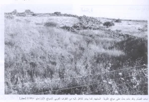
According to the field documentation published by Walid Khalidi, wild vegetation covered most of the village site, while the ruins of houses and broken iron bars protruded through the growth.
Part of an arched stone entrance remained standing, and cactus plants grew in the western section of the site and on the neighbouring hill.
Livestock pens belonging to the nearby settlement were established on the southern and eastern sides of the site.
A large and deep well remained at the northern edge of the site. It could be entered by a spiral staircase that had once been used for cleaning and maintenance.
Fig, palm, and chinaberry trees also grew at the site alongside wild vegetation.
This description reflects the condition of the site at the time of the field documentation relied upon by Walid Khalidi and should not necessarily be interpreted as a comprehensive field survey updated to 2026.
Sources
- PalQuest – Interactive Encyclopedia of the Palestine Question: al-Shajara.
- PalQuest: Abd al-Rahim Mahmud.
- PalQuest: Naji al-Ali.
- Palestine Remembered: al-Shajara, Tiberias District.
- Walid Khalidi, All That Remains: al-Shajara, as reproduced by Palestine Remembered.
- Palestine Remembered: Oral Testimony from al-Shajara Regarding the 1948 Battles.
- Walid Khalidi, All That Remains, entry on al-Shajara.
- Government of Palestine, censuses of 1922 and 1931.
- Government of Palestine, Department of Statistics, Village Statistics, 1945.
Photo gallery


Photos from the village's people
Photos sent in by visitors and published after review.
Add a photo of this village
Log in to add photos of this village.
Other villages from Tiberias

More from the archive

 Download Our Palestine App
The whole archive in the palm of your hand: depopulated villages, the Nakba, the massacres and Al-Aqsa — free, with no ads to erase the story.
Download Our Palestine App
The whole archive in the palm of your hand: depopulated villages, the Nakba, the massacres and Al-Aqsa — free, with no ads to erase the story.



Comments
No comments yet — be the first to write one.
Add your comment
Name and email are optional. Comments appear after review.