
The depopulated village of Kafr Saba / District of Tulkarm
Kafr Saba
About the depopulated village of Kafr Saba
- District
- Tulkarm
- Date Kafr Saba was occupied
- 13 May 1948
- Population in 1948
- 1,473
- Brigade that carried it out
- Alexandroni Brigade
- Who defended the village
- Local militia & Arab Liberation Army
- Distance from the governorate centre
- 16.5 km from Tulkarm
- Elevation above sea level
- 50 m
- Cause of displacement
- Direct military assault by Zionist forces, under the Haganah General Staff's policy that the area be emptied of its Arab residents by 15 May 1948; the villagers probably fled or were expelled after the second attack
- Extent of destruction
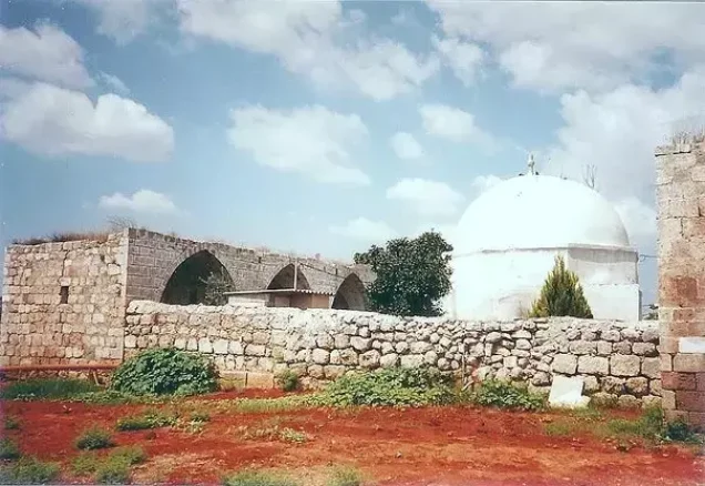
- Kafr Saba was completely defaced with the exception of its two shrines, the school, and ruins of the village cemetery.
- Ethnic cleansing
- Kafr Saba inhabitants were completely ethnically cleansed.
- Settlements built on the land of Kafr Saba before 1948
- Beyt Berl, established in 1947 northwest of the village site, on village lands; the town of Kefar Sava, founded in 1903 southwest of the village, has expanded to cover much of the village land
- Settlements built on the built-up area of Kafr Saba after 1948
- Newe Yamin, established in 1949 east of the village site on the land around the shrine of al-Nabi Yamin
Hover a dot to read the village name, or click to open its card.
Borders of the depopulated village of Kafr Saba
Kafr Saba: A Depopulated Palestinian Village in the Tulkarm District
Kafr Saba was a Palestinian village in the Tulkarm District, situated on the central coastal plain approximately 16.5 kilometres southeast of Tulkarm, at an average elevation of about 50 metres above sea level. Its population reached 1,270 in the 1944/1945 statistics. The Alexandroni Brigade attacked the village on 10 May 1948 but was initially repelled. A second assault on 13 May resulted in the village's occupation and the displacement of its Palestinian inhabitants during the Nakba and the occupation of Palestine in 1948.
- Subdistrict
- Tulkarm
- Distance from district center
- 16.5 km from Tulkarm
- Average Elevation
- 50 m above sea level
- Population in 1931
- 765 – includes 'Arab al-'Ubaydat
- Number of Houses in 1931
- 169 – includes 'Arab al-'Ubaydat
- Population in 1944/1945
- 1,270
- Estimated Population in 1948
- About 1,473 – a later demographic estimate, not an official census
- Total Land Area in 1945
- 9,688 dunams
- Attack and Depopulation
- The Haganah launched a ‘surprise’ attack on the village on 10 May 1948, which the defending Arab Liberation Army unit repelled; units of the Alexandroni Brigade then attacked and occupied it on 13 May 1948, according to Benny Morris as cited by Khalidi; the villagers probably fled or were expelled after the second attack.
- Final Israeli Control
- 13 May 1948, according to Benny Morris as cited by Khalidi; however, Arab Liberation Army commander Fawzi al-Qawuqji recorded on the same day that the initial thrust had been repelled and that fighting was still continuing, and the available sources give no later date for control of the village.
- Military Unit
- Units of the Alexandroni Brigade – according to Benny Morris as cited by Khalidi
- Cause of Depopulation
- Direct military assault by Zionist forces, under the Haganah General Staff's policy that the area be emptied of its Arab residents by 15 May 1948; the villagers probably fled or were expelled after the second attack
- Settlements Documented on Village Lands
- Beyt Berl, established in 1947 northwest of the village site, on village lands; Newe Yamin, established in 1949 east of the village site on the land around the shrine of al-Nabi Yamin; and the town of Kefar Sava, founded in 1903 southwest of the village, has expanded to cover much of the village land
Location
Kafr Saba stood on flat ground on the central coastal plain, approximately 16.5 kilometres southeast of Tulkarm, at an average elevation of about 50 metres above sea level.
The Jaffa–Tulkarm highway passed approximately 2.5 kilometres east of the village, while the Haifa–Lydda railway ran about 1.5 kilometres to the east and formed part of the boundary between the lands of Kafr Saba and Qalqilya.
Qalqilya was approximately 3 kilometres northwest of the village and was linked to it by a secondary road. Other local roads connected Kafr Saba with surrounding villages.
Miska lay to the northwest, Tabsur or Khirbat 'Azzun to the west, Biyar 'Adas to the south, and Jaljuliya to the southeast. The Jewish town of Kefar Sava stood southwest of the Palestinian village.
Kafr Saba Through History
The Palestinian village stood approximately 4 kilometres southeast of Khirbat Sabya, which some researchers have identified with the site of Roman Caphar Saba.
During the Crusader period, the village was known by a name rendered as Kapharseb.
The geographer al-Muqaddasi mentioned Kafr Saba in 985 CE, describing it as a large village with a mosque situated on the road to Damascus.
The Persian traveller Nasir Khusraw also mentioned it in 1047, describing a settlement rich in fig and olive trees along the road to Ramla.
In 1596, Kafr Saba was a village in the nahiya of Bani Sa'b in the Nablus district, with an estimated population of approximately 231.
The inhabitants paid taxes on wheat, barley, goats, beehives, and other forms of production.
In 1730, the Egyptian Sufi traveller Mustafa As'ad al-Luqaymi visited the area and mentioned a shrine dedicated to Binyamin, also known as al-Nabi Yamin.
Architecture
In the late nineteenth century, Kafr Saba was described as a village built of stone and adobe brick on a low hill, with an estimated population of about 800.
The village had an approximately square plan and was surrounded by sandy ground, while olive groves were visible to the north.
Several springs lay to the east and northeast, one of which supplied drinking water to the inhabitants.
During the British Mandate, housing expanded toward the Tulkarm–Jaffa road, while new agricultural land was cultivated west of the village.
The Arab built-up area covered approximately 26 dunams in the 1944/1945 statistics.
Population
Kafr Saba had 546 inhabitants in the 1922 census.
By the 1931 census, the population had increased to 765 people living in 169 houses. These figures included 'Arab al-'Ubaydat.
According to the 1944/1945 statistics, the population reached 1,270.
The Palestinian inhabitants of the village were Muslims.
The estimates of approximately 1,473 inhabitants in 1948 and 9,047 refugees and descendants in 1998 published by Palestine Remembered are later estimates rather than official British Mandate census figures.
Population of Kafr Saba
- 1596About 231Historical estimate based on Ottoman records
- Late nineteenth centuryAbout 800Historical estimate
- 1922546Official census
- 1931765Official census; includes 'Arab al-'Ubaydat
- 1944/19451,270Government of Palestine statistics
- 1948About 1,473Later estimate
- 19989,047Estimate of refugees and their descendants
Number of Houses
The 1931 census recorded 169 houses in Kafr Saba, including the houses associated with 'Arab al-'Ubaydat.
The Mosque and Shrines
Kafr Saba had a mosque serving its Muslim population.
The village also contained two well-known shrines: the shrine of al-Nabi Yamin, or Binyamin, and the shrine of al-Nabi Yahya.
Local Palestinian accounts provide additional details concerning the village mosque, its imam and muezzin before the Nakba, and two Sufi zawiyas associated with the al-Najjar and al-Balasima families. These details derive from local documentation and are not all recorded to the same degree in the principal Walid Khalidi and PalQuest accounts.
Education
The principal reference sources confirm that Kafr Saba had one elementary school.
According to local village documentation, a school or kuttab existed in the late Ottoman period by approximately 1893 and enrolled 55 pupils.
The same local source states that the school reopened during the British Mandate in 1930 with classes through the fourth grade and was later expanded through the sixth grade.
Because these specific dates and details are not fully reproduced in the principal Walid Khalidi and PalQuest entries, they are presented as local Palestinian documentation.
Land of Kafr Saba
According to the 1944/1945 statistics, Kafr Saba had a total land area of 9,688 dunams.
Arab ownership amounted to 6,019 dunams, Jewish ownership to 3,144 dunams, while 525 dunams were classified as public land.
Land Ownership in Kafr Saba in 1944/1945
- Arab ownership6,019 dunums62%
- Jewish ownership3,144 dunums32%
- Public land525 dunums5%
Agriculture and Economic Life
The inhabitants depended primarily on agriculture and cultivated wheat, cereals, watermelons, cucumbers, vegetables, citrus fruits, bananas, and olives.
According to the 1944/1945 statistics, citrus and banana cultivation covered 2,225 dunams, including 1,026 Arab-owned dunams and 1,199 Jewish-owned dunams.
Irrigated and plantation land covered 579 dunams, including 355 Arab-owned dunams and 224 Jewish-owned dunams.
Cereal cultivation covered a total of 6,337 dunams: 4,600 Arab-owned dunams, 1,675 Jewish-owned dunams, and 62 dunams of public land.
The Palestine Remembered table gives 4,662 dunams in the Arab cereal category, apparently combining the 62 dunams of public cereal land with Arab-owned land. This article therefore follows the detailed ownership breakdown given by PalQuest.
Approximately 30 dunams of Arab-owned cultivated land were planted with olive trees. This represents a crop category within plantation land and should not be added separately to the overall totals.
Land Use in Kafr Saba in 1944/1945, in Dunams
- Arab
- Jewish
- Public
- Citrus and bananas2,225 dunums
- Irrigated and plantation land579 dunums
- Cereals6,337 dunums
- Built-up area26 dunums
- Uncultivable land521 dunums
Roads and Transportation
The Jaffa–Tulkarm highway passed approximately 2.5 kilometres east of Kafr Saba.
The Haifa–Lydda railway line ran approximately 1.5 kilometres east of the village and formed part of the boundary between Kafr Saba and Qalqilya lands.
A secondary road linked Kafr Saba with Qalqilya, approximately 3 kilometres to the northwest, while other roads connected it with nearby villages.
Attacks on Kafr Saba
In December 1947, representatives of Kafr Saba met representatives of neighbouring Jewish settlements, and contemporary accounts state that both sides pledged at that time to maintain peace.
By May 1948, however, the Alexandroni Brigade had been assigned to capture Kafr Saba as part of a military policy aimed at clearing the Arab population from the heavily settled area north of Tel Aviv before the end of the British Mandate.
The 10 May Attack
On 10 May 1948, Haganah forces launched a surprise assault on Kafr Saba.
According to Arab Liberation Army records transmitted by Walid Khalidi and PalQuest, the force defending the village repelled the attack from the outset.
Arab Liberation Army commander Fawzi al-Qawuqji stated that the assault caused panic among the villagers and believed that it was intended to reconnoitre Arab positions in preparation for a wider advance toward Qalqilya.
The Occupation and Depopulation of Kafr Saba
On 13 May 1948, the Alexandroni Brigade launched a second assault on Kafr Saba.
PalQuest and Walid Khalidi transmit al-Qawuqji's account that the fighting took place along a north–south axis and continued after the initial advance was repelled.
The detailed PalQuest account attributes the village's occupation that day to units of the Alexandroni Brigade.
Khalidi considers it probable that the villagers either fled or were expelled following the second assault. Their arrival in Qalqilya contributed to the temporary evacuation of that town.
There is a chronological discrepancy in the sources. Palestine Remembered's summary table and some shorter documents give 15 May, whereas the detailed narrative dates the decisive assault and occupation to 13 May. This article therefore uses 13 May as the best-documented date of the military capture, while noting that the depopulation or consolidation of control may have been completed by 15 May.
The principal PalQuest entry does not identify a separate named military operation for the occupation of Kafr Saba. The capture is therefore attributed directly to the Alexandroni Brigade rather than to an inadequately documented operation name.
Israeli military accounts are cited here only as transmitted through Walid Khalidi and PalQuest and not through direct reliance on Israeli sources.
Occupation and Depopulation Chronology
- 1947
Settlement on village lands
The settlement of Beyt Berl was established northwest of the village site, on village lands.
- 10 May 1948
First attack on the village
The Haganah launched a ‘surprise’ attack on the village that was repelled ‘from the start’, according to Arab Liberation Army commander Fawzi al-Qawuqji, who said it caused panic among the villagers. Arab Liberation Army records show that the unit defending the village ordered the villagers to return after this attack.
- 13 May 1948
Second attack
Qawuqji recorded a second attack along a north–south axis from Tulkarm to Kafr Saba, and stated that the initial thrust was repelled with heavy Haganah losses and that fighting was still continuing.
- 13 May 1948
Final occupation
According to Israeli historian Benny Morris as cited by Khalidi, units of the Alexandroni Brigade attacked and occupied the village on this day; the brigade had been charged with its capture under the Haganah General Staff's policy that the area be emptied of its Arab residents by 15 May. This differs from Qawuqji's record for the same day, which states that fighting was still continuing.
- After 13 May 1948
Depopulation of the village
Khalidi considers it probable that the villagers fled or were expelled after the second attack, and that their arrival in Qalqilya led, in turn, to the temporary evacuation of that town.
- 1949
Settlement on village lands
The settlement of Newe Yamin, named after al-Nabi Yamin, was established east of the village site on the land around the shrine of al-Nabi Yamin.
Israeli Settlements on the Lands of Kafr Saba
Kefar Sava
The Jewish town of Kefar Sava was established in 1903 southwest of the Palestinian village and had a population of more than 5,000 by 1948.
After the Nakba, it expanded considerably and came to cover much of the Palestinian village site and lands.
Beyt Berl
Beyt Berl was established in 1947 northwest of the village site and stands on Kafr Saba's lands.
Newe Yamin
Newe Yamin was established in 1949 east of the village site on land surrounding the shrine of al-Nabi Yamin, after which it was named.
Nir Eliyyahu
Nir Eliyyahu, established in 1950 approximately one kilometre northeast of the village site, lies on the lands of neighbouring Qalqilya rather than on Kafr Saba's lands.
- 1903Kefar Sava
Originally southwest of the village; expanded after 1948 across much of its lands
- 1947Beyt Berl
Established on village lands northwest of the site
- 1949Newe Yamin
Established east of the village site on its lands around al-Nabi Yamin shrine
- 1950Nir Eliyyahu
Nearby, but established on the lands of Qalqilya
Kafr Saba After the Nakba
According to the field documentation relied upon by Walid Khalidi, the village site was used for new residential and industrial development that became part of the expanding town of Kefar Sava.
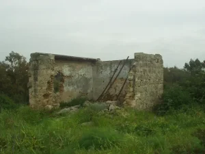
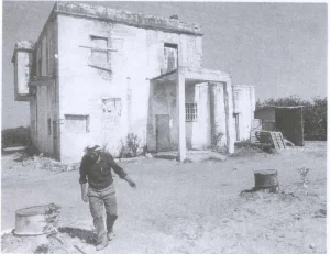
Not all of the Palestinian village houses were destroyed. Several old buildings survived within the expanded urban area, and some were later used for commercial purposes.
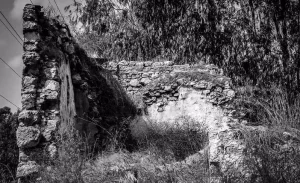
The two shrines of al-Nabi Yamin and al-Nabi Yahya, the village school, and the ruins of the cemetery also remained.
The shrines have arched entrances and are surmounted by domes.
The surrounding village lands were used for cultivation.
This description reflects the condition of the site during the field documentation relied upon by Walid Khalidi and should not necessarily be interpreted as a comprehensive survey updated to 2026.
Sources
- PalQuest – Interactive Encyclopedia of the Palestine Question: Kafr Saba.
- PalQuest: Kafr Saba.
- Palestine Remembered: Kafr Saba, Tulkarm District.
- Walid Khalidi, All That Remains: Kafr Saba, as reproduced by Palestine Remembered.
- Local Palestinian documentation on the history and families of Kafr Saba.
- Walid Khalidi, All That Remains, entry on Kafr Saba.
- Fawzi al-Qawuqji, Arab Liberation Army records and reports, as transmitted by Walid Khalidi and PalQuest.
- Government of Palestine, censuses of 1922 and 1931.
- Government of Palestine, Department of Statistics, Village Statistics, 1945.
Photo gallery


Photos from the village's people
Photos sent in by visitors and published after review.
Add a photo of this village
Log in to add photos of this village.
Other villages from Tulkarm
More from the archive
 Download Our Palestine App
The whole archive in the palm of your hand: depopulated villages, the Nakba, the massacres and Al-Aqsa — free, with no ads to erase the story.
Download Our Palestine App
The whole archive in the palm of your hand: depopulated villages, the Nakba, the massacres and Al-Aqsa — free, with no ads to erase the story.



Comments
No comments yet — be the first to write one.
Add your comment
Name and email are optional. Comments appear after review.