
The depopulated village of Nuseirat Village / District of Tulkarm
Nuseirat Village
About the depopulated village of Nuseirat Village
- District
- Tulkarm
- Date Nuseirat Village was occupied
- 03 February 1948
- Population in 1948
- 200
- Brigade that carried it out
- Haganah
- Distance from the governorate centre
- 9.5–10 km southwest of Tulkarm
- Cause of displacement
- Military attack and pressure; the entire population left as a result of military operations.
- Extent of destruction
- The village was almost completely destroyed in 1949.
- Ethnic cleansing
- Complete forced displacement of the population during the Nakba; the term “ethnic cleansing” itself does not appear in the primary document.
- Settlements built on the built-up area of Nuseirat Village after 1948
- Ein Sarid – established in 1950 on the site/ruins of Ayn al-Sirat.
Hover a dot to read the village name, or click to open its card.
'Arab al-Nusayrat ('Ayn al-Sirat) – Depopulated Palestinian Locality of the Tulkarm Subdistrict
'Arab al-Nusayrat was a Palestinian community in the Tulkarm Subdistrict, recorded in Mandate-era sources as Nuseirat and 'Arab el Nuseirat. Later Palestinian local documentation associates the community with a village known as 'Ayn al-Sirat, inhabited by members of the al-Nusayrat tribe together with other Palestinian families.
The locality stood in the coastal plain of the Tulkarm Subdistrict, approximately 4 km west of Qalansuwa according to Palestinian community documentation, within the rural zone associated with al-Tayyiba and Qalansuwa.
'Arab al-Nusayrat presents an important statistical difficulty: the Government of Palestine did not treat it as an independent statistical unit in the 1944/45 Village Statistics. Instead, Nuseirat was combined with al-Tayyiba, Khirbat al-'Amarir, Khirbat Takla, and Kefar Ya'vetz. Figures for that combined unit must therefore not be attributed to al-Nusayrat alone.
Name and Identification
Mandate records use the forms Nuseirat and 'Arab el Nuseirat.
Later Palestinian oral-history documentation uses the name 'Ayn al-Sirat for a locality inhabited by al-Nusayrat families and other households and identifies Ein Sarid as having been established on its site after the Nakba.
The geographic setting, later settlement history, and association with al-Nusayrat strongly connect the two names, but the official Mandate statistical tables do not explicitly state that Nuseirat and 'Ayn al-Sirat are interchangeable names. This article therefore presents 'Ayn al-Sirat as the local name associated with the al-Nusayrat settlement while preserving that qualification.
Location
'Arab al-Nusayrat stood in the coastal plain of the Tulkarm Subdistrict in the rural area between al-Tayyiba, Qalansuwa, and the agricultural settlements farther west.
Palestinian community documentation places the village site approximately 4 km west of Qalansuwa.
The surrounding area was fertile and strongly associated with citrus groves, vegetable cultivation, and trade with al-Tayyiba, Qalansuwa, Tulkarm, and other coastal towns.
Relationship with Al-Tayyiba
The close connection between Nuseirat and al-Tayyiba is visible in the official 1944/45 Village Statistics, which combined al-Tayyiba, Khirbat al-'Amarir, Nuseirat, Khirbat Takla, and Kefar Ya'vetz in a single statistical unit.
Many displaced inhabitants of the al-Nusayrat locality later settled in al-Tayyiba, where their descendants remained part of the local community.
Population
No complete independent official population series can safely be constructed for 'Arab al-Nusayrat.
| Year | Population | Nature of Figure / Notes |
|---|---|---|
| 1931 | No figure used independently | 'Arab el Nuseirat appears in the Tulkarm census tables, but the treatment of tribal and dependent localities makes an independent figure unsafe without a more detailed reconstruction of the original table. |
| 1944/45 | 4,290 Arabs | Combined official figure for al-Tayyiba, Khirbat al-'Amarir, Nuseirat, and Khirbat Takla; not the population of Nuseirat alone. |
| 1948 | Approx. 200–300 | Later Palestinian secondary and local estimates for the displaced community, not an independent official census. |
One later Palestinian database gives approximately 200 inhabitants in 1948, while Palestinian community documentation gives roughly 300. Neither figure is treated here as an official census count.
Number of Houses
The Mandate statistics do not provide an independently usable house count for 'Arab al-Nusayrat immediately before the Nakba.
Local oral history concerning 'Ayn al-Sirat estimates that approximately fifty houses existed before demolition. This is a retrospective community estimate rather than an official house count.
Land Ownership – Combined 1944/45 Statistical Unit
No independent official land-area figure is available for 'Arab al-Nusayrat alone.
The Government of Palestine combined its lands statistically with al-Tayyiba, Khirbat al-'Amarir, Khirbat Takla, and Kefar Ya'vetz, producing a total unit of 40,625 dunums.
Using the ownership terminology employed by Palestine Remembered, while emphasizing that these are combined-unit figures:
- Palestinian32,750 dunums40%
- Transferred to Zionists6,294 dunums8%
- Communal1,581 dunums2%
- Combined Total40,625 dunums50%
This corresponds to the official categories of 32,750 Arab dunums, 6,294 Jewish dunums, and 1,581 Public dunums.
The published statistics do not permit the independent al-Nusayrat share to be separated reliably.
Land Use in 1944/45
The following figures apply to the entire combined al-Tayyiba–Khirbat al-'Amarir–Nuseirat–Khirbat Takla–Kefar Ya'vetz statistical unit:
- Arab
- Jewish
- Public
- Citrus and Bananas1,878 dunums
- Plantations and Irrigable Land3,276 dunums
- Cereals28,417 dunums
- Built-up Area291 dunums
- Non-Cultivable Land6,763 dunums
None of these acreage figures should be presented as independent land-use statistics for 'Arab al-Nusayrat alone.
Local Estimate of 'Ayn al-Sirat Lands
Palestinian oral-history documentation offers a very different local estimate, stating that approximately 3,000 dunums were associated with the settlement and that these lands had originally formed part of al-Tayyiba's communal holdings.
This figure represents local historical memory and does not appear as a separate cadastral unit in the 1945 Village Statistics. It is therefore not mathematically merged with the official combined statistics.
Economic Life
The community depended primarily on agriculture, work in citrus groves, and livestock raising.
Local oral testimony records oranges, wheat, barley, eggplant, okra, cucumbers, tomatoes, and other crops.
Residents also kept cattle, camels, sheep, chickens, and horses.
Agricultural produce was marketed in Tulkarm and Jaffa as well as in nearby communities.
This pattern is consistent with the wider agricultural economy of the Tulkarm coastal plain, where citrus, vegetables, and field crops expanded substantially during the Mandate period.
Village Society and Buildings
Local documentation states that 'Ayn al-Sirat expanded during the 1930s.
A large guesthouse or diwan belonging to mukhtar 'Abd al-Latif Rabi' served as a gathering place for men from the village and surrounding communities.
Oral-history sources mention families including al-Luh, 'Amrur, Takla, al-Tawil, and al-Nusayrat among the inhabitants.
These details are preserved as local oral history because no independent Khalidi statistical entry exists for 'Arab al-Nusayrat.
The Mosque and Surviving Building
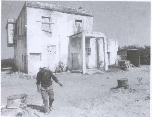
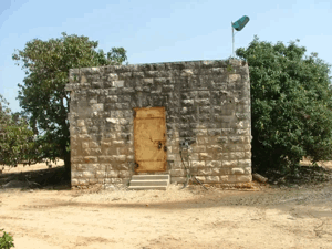
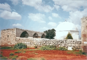
Palestine Remembered documents a surviving building identified by contributors as the mosque of the depopulated village of 'Arab al-Nusayrat and states that it was later converted into a synagogue.
Another Palestinian oral-history account instead states that the surviving building was the house of mukhtar 'Abd al-Latif Rabi', which was converted into a synagogue.
The local sources therefore disagree on the original identity of the surviving structure. The secure conclusion is that a Palestinian building survived and was subsequently used as a synagogue, while identifying it conclusively as the mosque or the mukhtar's house requires additional architectural or cadastral evidence.
Depopulation of 'Arab al-Nusayrat
The strongest available chronological evidence comes from an intelligence report dated 30 June 1948 and published by PalQuest.
The report records 3 February 1948 for “Arab an-Nuseirat,” states that the entire population left, and attributes the evacuation, in the report's own terminology, to “our actions.”
It identifies al-Tayyiba and Qalansuwa as the destinations of the displaced inhabitants and states that the village was empty.
This article therefore treats 3 February 1948 as the strongest documented date for the depopulation of 'Arab al-Nusayrat.
Disagreement Over the Date
Some later Palestinian community material places the displacement in April 1948.
The June 1948 intelligence report, however, explicitly records 3 February and is substantially closer in time to the event.
3 February is therefore preferred while the later April tradition is preserved as a documented discrepancy.
The Alexandroni Brigade
Some later Palestinian secondary sources identify the Alexandroni Brigade as the force associated with the depopulation of al-Nusayrat, and a local oral-history account also describes Alexandroni activity in the area.
The intelligence report that establishes the 3 February date, however, does not identify a brigade or battalion, and PalQuest does not provide a separate village entry naming a village-specific military unit.
The most precise formulation is therefore: general Zionist military organization: Haganah; Alexandroni Brigade: identified by later Palestinian secondary and local sources but not independently confirmed in the principal al-Nusayrat document; village-specific battalion: unknown.
Occupation and Depopulation Chronology
- January–early February 1948
Growing Zionist military activity in the central coastal region
Military attacks and pressure intensified against Palestinian communities in the coastal plain.
- 3 February 1948
Depopulation of 'Arab al-Nusayrat
The intelligence report published by PalQuest states that the entire population left as a result of what the report calls “our actions.”
- 3 February 1948
Destinations of the inhabitants
The displaced inhabitants went primarily to al-Tayyiba and Qalansuwa; the report states that the village became empty.
- Not separately documented
Direct military entry
The principal report does not provide a detailed battle narrative or identify the unit that physically occupied the site.
- 1949 according to local oral history
Demolition of village houses
Palestinian oral-history documentation states that most of the approximately fifty houses were demolished.
- 1950
Establishment of Ein Sarid
Palestinian local sources associate Ein Sarid with the former al-Nusayrat/'Ayn al-Sirat village site.
Israeli Settlement on the Village Site
Palestinian local documentation associates the former 'Arab al-Nusayrat/'Ayn al-Sirat site with Ein Sarid, established in 1950 after the Palestinian inhabitants had been displaced.
Because the 1945 Government of Palestine statistics do not provide a separate cadastral unit for al-Nusayrat, the most accurate formulation is that Ein Sarid was established on the site or ruins of the depopulated Palestinian settlement associated with 'Arab al-Nusayrat. The precise acreage of independently defined al-Nusayrat land incorporated into the settlement cannot be calculated from the published official tables.
'Arab al-Nusayrat Today
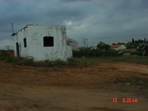
Most of the Palestinian built environment of 'Arab al-Nusayrat/'Ayn al-Sirat disappeared after the Nakba.
Palestinian oral history states that the village had approximately fifty houses and that most were demolished in 1949.
Palestine Remembered documents a surviving Palestinian structure at the site that was later used as a synagogue, although local accounts disagree over whether the original building was the village mosque or the mukhtar's house.
Later Palestinian community documentation indicates that many displaced villagers and their descendants settled in al-Tayyiba.
These descriptions rely partly on oral history and community field documentation and do not constitute a comprehensive archaeological or on-site survey of the locality's condition in 2026.
Sources
- PalQuest – Israeli Intelligence Report on the Depopulation of Palestine, including 'Arab an-Nuseirat on 3 February 1948
- Village Statistics 1945 – Population and Land Ownership, Tulkarm Subdistrict
- Village Statistics 1945 – Cultivable Land, Tulkarm Subdistrict
- Village Statistics 1945 – Built-up and Non-Cultivable Land, Tulkarm Subdistrict
- Palestine Remembered – Community documentation of the al-Nusayrat village site west of Qalansuwa
- Palestine Remembered – Qalansuwa, including community documentation related to 'Arab al-Nusayrat
- Arab48 – Palestinian oral history of 'Ayn al-Sirat and Ein Sarid
- Palestinian Encyclopedia – Arab tribes of the Tulkarm district, including al-Nusayrat
- Institute for Palestine Studies – Walid Khalidi, All That Remains
Photos from the village's people
Photos sent in by visitors and published after review.
Add a photo of this village
Log in to add photos of this village.
Other villages from Tulkarm
More from the archive
 Download Our Palestine App
The whole archive in the palm of your hand: depopulated villages, the Nakba, the massacres and Al-Aqsa — free, with no ads to erase the story.
Download Our Palestine App
The whole archive in the palm of your hand: depopulated villages, the Nakba, the massacres and Al-Aqsa — free, with no ads to erase the story.



Comments
No comments yet — be the first to write one.
Add your comment
Name and email are optional. Comments appear after review.