
The depopulated village of Barqusya / District of Hebron
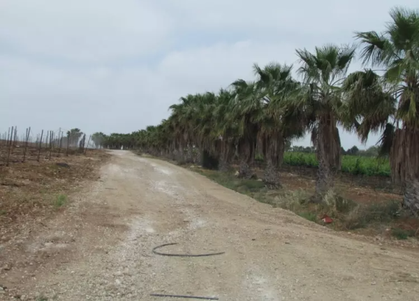
Barqusya
About the depopulated village of Barqusya
- District
- Hebron
- Date Barqusya was occupied
- 10 July 1948
- Population in 1948
- 380
- Military operation
- Operation An-Far
- Brigade that carried it out
- Givati Brigade
- Distance from the governorate centre
- 31 (km) Northwest of Hebron
- Elevation above sea level
- 175 m
- Cause of displacement
- Military assault by Zionist troops
- Extent of destruction
- Barqusya was completely obliterated and defaced.
- Ethnic cleansing
- Barqusya inhabitants were completely ethnically cleansed.
Hover a dot to read the village name, or click to open its card.
Borders of the depopulated village of Barqusya
Barkusya (Barqusya): A Depopulated Palestinian Village in the Hebron District
Barkusya, commonly rendered as Barqusya in Walid Khalidi and PalQuest, was a depopulated Palestinian village in the Hebron District. It was located approximately 31 kilometers northwest of Hebron on a hill descending toward the northwest in the western foothills of the Hebron Mountains, at an average elevation of about 175 meters above sea level.
The Government of Palestine's 1944/1945 statistics recorded 330 inhabitants, all Muslims, and a total land area of 3,216 dunums. During the Nakba and the occupation of Palestine in 1948, Barkusya was probably occupied on 9–10 July during Operation An-Far, an offensive carried out by the First Battalion of the Giv'ati Brigade. Palestinian oral documentation from the village identifies 9 July as the day of the assault, destruction, and displacement.
Key Facts About Barkusya
- Subdistrict: Hebron.
- Distance from Hebron: approximately 31 kilometers northwest.
- Average elevation: approximately 175 meters above sea level.
- Population in 1944/1945: 330, all Muslims.
- Estimated population in 1948: 383 according to Palestine Remembered.
- Total land area: 3,216 dunums.
- Date of occupation: probably 9–10 July 1948; local Palestinian testimony identifies 9 July.
- Military operation: Operation An-Far.
- Military unit: First Battalion of the Giv'ati Brigade.
- Post-1948 Israeli settlements on village lands: none.
Barkusya or Barqusya?
The village name is rendered differently in the available sources. Walid Khalidi and PalQuest use the Arabic form Barqusya, while local documentation produced by villagers and their descendants strongly favors Barkusya, with a k sound.
Local researchers support the Barkusya form by referring to pre-Nakba property records, personal documents, local legal records, and earlier written references.
This article therefore uses Barkusya as its principal rendering while retaining Barqusya as the form commonly used in Khalidi, PalQuest, and other modern reference works.
Location of Barkusya
Barkusya stood on a hill descending northwestward in the western foothills of the Hebron Mountains.
A dirt road ran southwest from the village and became a secondary road near Summil, from where it connected with the main highway between the coastal city of al-Majdal and Hebron.
Palestinian local documentation places Bi'lin to the northwest, Tall al-Safi to the northeast, Zikrin to the east, Zayta to the southeast, and Summil to the southwest.
Some of the villagers' western lands extended toward the Gaza Subdistrict boundary near al-Jaladiyya and Tall al-Turmus.
The Built Environment of Barkusya
In the late nineteenth century, Barkusya was described as a medium-sized village with an approximately pentagonal outline. Its houses were built of stone and mud.
During the early decades of the twentieth century, construction expanded slowly, primarily northward along the road leading to Bi'lin.
During the final years of the British Mandate, one of the village's two principal hamulas moved approximately one kilometer south, extending the built-up area in that direction.
The village contained a small mosque and a handful of small shops.
The built-up area covered approximately 31 dunums according to the 1944/1945 statistics.
Population of Barkusya
An important discrepancy exists concerning the 1922 census. Palestine Remembered and several Palestinian secondary sources give a population of 158, but the official 1922 Census of Palestine lists Berkusia with 198 inhabitants, all Muslims: 90 males and 108 females.
This article therefore uses the official figure of 198 while noting the lower figure published in several secondary sources.
The 1931 Census of Palestine recorded 258 inhabitants living in 53 houses. Palestinian local documentation gives a breakdown of 133 males and 125 females.
The Government of Palestine's 1944/1945 statistics recorded a population of 330, all Arab Muslims.
The figures of 383 inhabitants for 1948 and 2,351 refugees for 1998 published by Palestine Remembered are later demographic estimates rather than official censuses.
Population of Barkusya
- 1922198Official Census of Palestine; all Muslims
- 1931258Official census; living in 53 houses
- 1944/1945330Government of Palestine statistics; all Muslims
- 1948383Later estimate published by Palestine Remembered
- 19982,351Later refugee-population estimate published by Palestine Remembered
A Palestinian oral-history account estimates the population immediately before displacement at approximately 360–400, broadly consistent with the later 1948 estimate of 383.
Number of Houses in Barkusya
The 1931 Census of Palestine recorded 53 houses in Barkusya.
The figure of 78 houses for 1948 published by Palestine Remembered is a later estimate rather than an official census figure.
Number of Houses in Barkusya
- 193153Official census
- 194878Later estimate published by Palestine Remembered
Families of Barkusya
According to local Palestinian documentation, most inhabitants of Barkusya belonged to the al-Qawasmi family network, with two principal related groups: the 'Abdallah al-Qawasmi and Khushan al-Qawasmi clans.
Each group had its own communal meeting place, while the movement of one hamula toward the southern part of the village during the final Mandate years influenced the physical expansion of the settlement.
Local documentation states that many villagers and their descendants later settled in Jordan, particularly in Irbid, al-Ramtha, and Amman.
Education in Barkusya
No independent village school is documented in Walid Khalidi's principal account. Children from Barkusya instead attended school in nearby Tall al-Safi to the northwest.
Local documentation from the surrounding area also indicates that the school in Zikrin received pupils from Barkusya during some periods.
The village therefore relied on schools in neighboring Palestinian communities for formal education.
Water Sources in Barkusya
A well west of Barkusya had supplied the village with drinking water since the late nineteenth century.
Palestinian local documentation identifies the main well as Bi'r Abu Kharza and also records a second source known as the western well, located west of the village center.
Local tradition associates the water feeding these wells with nearby Wadi al-Barshim. This is presented as local village documentation rather than as an official hydrological classification.
Land Ownership in Barkusya
The Government of Palestine's 1944/1945 statistics recorded a total land area of 3,216 dunums for Barkusya. No Jewish land ownership was recorded.
Arab ownership accounted for 3,214 dunums, while 2 dunums were classified as public land.
The Arabic Palestine Remembered table uses the categories “Palestinian,” “Transferred to Zionists,” and “Masha'.” These terms are preserved below as that source's terminology.
Land Ownership in Barkusya, 1944/1945, Using Palestine Remembered Terminology
- Palestinian3,214 dunums100%
- Transferred to Zionists0 dunums0%
- Masha' (source terminology)2 dunums<1%
Land Use in Barkusya in 1944/1945
A total of 2,488 dunums was cultivated or classified as cultivable, representing approximately 77 percent of the village's total land area. All of this cultivable land was classified as Arab land.
Cereals occupied 2,460 dunums, while plantations and irrigable land covered 28 dunums.
The built-up area covered 31 dunums. Non-cultivable land totaled 697 dunums, consisting of 695 dunums of Arab land and 2 dunums of public land.
Land Use in Barkusya According to the 1944/1945 Statistics
- Arab
- Jewish
- Public
- Plantations and Irrigable Land28 dunums
- Cereals2,460 dunums
- Built-up Area31 dunums
- Non-Cultivable Land697 dunums
Economic Life in Barkusya
The economy of Barkusya depended primarily on rainfed agriculture, and cereals occupied the great majority of its cultivated land.
The villagers also tended fruit trees, including grapes, figs, and pomegranates. Palestinian local documentation additionally records sesame cultivation.
Sheep and goat raising formed another important element of the local economy, while a handful of small shops operated within the village.
Operation An-Far
The occupation of Barkusya was associated with Operation An-Far, an Israeli military offensive carried out by the First Battalion of the Giv'ati Brigade on the southern front between 8 and 15 July 1948.
The operation took place during the Ten Days of fighting between the first and second truces. It sought to expand Giv'ati's area of control southward and eastward and to establish a connection with Jewish settlements in the Negev.
PalQuest records that the First Battalion's orders called for civilians to be expelled from the areas it occupied.
The offensive displaced the inhabitants of numerous Palestinian villages around the intersection of the Hebron, Gaza, and Ramla subdistricts, including Barkusya, Bi'lin, al-Tina, al-Khayma, Mughallis, Qazaza, Sajad, Tall al-Safi, Tall al-Turmus, and Zayta.
The Occupation of Barkusya on 9–10 July 1948
Walid Khalidi and PalQuest consider it most probable that Barkusya was occupied on 9–10 July 1948 during Operation An-Far.
Palestine Remembered and Palestinian oral documentation from Barkusya identify 9 July 1948 more specifically as the day of the assault and displacement.
This article therefore uses 9–10 July as the reference range for the military occupation while preserving the local Palestinian account that identifies 9 July.
These events occurred after the first truce ended on 8 July and before the second truce began on 18 July. The claim that 9 July marked the beginning of the second truce is therefore incorrect.
The Displacement of Barkusya's Inhabitants
The displacement of Barkusya took place in the context of the Giv'ati Brigade's attacks during Operation An-Far.
Palestinian oral testimony from villagers states that Giv'ati forces attacked Barkusya on 9 July and burned and destroyed the village, forcing its inhabitants to leave.
This testimony fits the broader operational context documented by PalQuest, which records that orders issued to Giv'ati's First Battalion called for the expulsion of civilians from the occupied area and that the operation led to the depopulation of numerous Palestinian villages.
Palestine Remembered's statistical card additionally labels Barkusya as the site of a massacre, but the page does not provide a detailed account, date, or documented casualty figure for a separate massacre. Walid Khalidi's principal village entry does not document such an event in comparable detail. This article therefore does not present a separate massacre at Barkusya as conclusively established without additional evidence.
Details originating in Israeli military records are presented through the Palestinian intermediary sources Walid Khalidi and PalQuest rather than through independent reliance on Israeli sources.
The August 1948 Settlement Plan
Approximately six weeks after the occupation of Barkusya, plans were already being prepared for new settlements in the area.
On 20 August 1948, the Jewish National Fund submitted a plan to the Israeli authorities showing two proposed settlements on the lands associated with Barkusya and neighboring Summil. The proposed settlements were named Segula and Nahala.
According to the information presented by Walid Khalidi, the proposal envisioned the two new settlements replacing the two Palestinian villages.
The proposal, however, should not be confused with the final location of the settlements that were actually established.
Israeli Settlements and Barkusya's Lands
According to Walid Khalidi and PalQuest, no Israeli settlement was ultimately established on the lands of Barkusya itself.
Segula and Nahala lie close to the former village site to the southwest, but both stand on the lands of neighboring Summil, across the former boundary between the Hebron and Gaza subdistricts.
The August 1948 JNF proposal should therefore be distinguished from the actual post-1948 settlement geography.
Barkusya After the Nakba
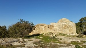
According to Walid Khalidi's historical field description, no complete village houses remained standing at Barkusya.
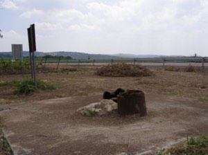
Several graves remained visible among wild vegetation, including one with an inscribed headstone, and remnants of a village well could also be seen.
A variety of trees, including palms, grew on the site, while the land was used for grazing and for the cultivation of grapes and other fruit trees.
Palestinian local documentation additionally records limited remains associated with houses of the Khushan family, Bi'r Abu Kharza, the western well, cactus plants, and palm trees.
Khalidi's description derives from fieldwork undertaken for All That Remains, while the local documentation also reflects earlier visits to the site. Neither should automatically be treated as a comprehensive field survey of conditions in 2026.
Sources
- PalQuestPalQuest – Interactive Encyclopedia of the Palestine Question: Barqusya
- PalQuestPalQuest – Interactive Encyclopedia of the Palestine Question: Operation An-Far
- Palestine RememberedPalestine Remembered: Barqusya – Hebron District
- Palestine RememberedPalestine Remembered: Barqusya in Walid Khalidi's All That Remains
- palqura.comPalestinian Villages Encyclopedia: Barkusya – Local Village Documentation
- pal48.psFilastunna: The Depopulated Village of Barkusya / Barqusya
- pcbs.gov.psPalestinian Central Bureau of Statistics: Historical Censuses and Reports


Photos from the village's people
Photos sent in by visitors and published after review.
Add a photo of this village
Log in to add photos of this village.
Other villages from Hebron

More from the archive
 Download Our Palestine App
The whole archive in the palm of your hand: depopulated villages, the Nakba, the massacres and Al-Aqsa — free, with no ads to erase the story.
Download Our Palestine App
The whole archive in the palm of your hand: depopulated villages, the Nakba, the massacres and Al-Aqsa — free, with no ads to erase the story.



Comments
No comments yet — be the first to write one.
Add your comment
Name and email are optional. Comments appear after review.