
The depopulated village of Al-Jammasin al-Sharqi / District of Jaffa

Al-Jammasin al-Sharqi
About the depopulated village of Al-Jammasin al-Sharqi
- District
- Jaffa
- Date Al-Jammasin al-Sharqi was occupied
- 17 March 1948
- Population in 1948
- 850
- Distance from the governorate centre
- 9 (km) Northeast of Jaffa
- Elevation above sea level
- 25 m
- Extent of destruction
- al-Jammasin al-Sharqi was mostly destroyed with the exception of few houses, which are currently occupied by Israeli Jewish settlers.
- Ethnic cleansing
- al-Jammasin al-Sharqi inhabitants were partially intimidated by the Haganah into fleeing their homes on January 7th 1948, and complete ethnic cleansing on March 17th, 1948.
Hover a dot to read the village name, or click to open its card.
Borders of the depopulated village of Al-Jammasin al-Sharqi
Al-Jammasin al-Sharqi – Depopulated Palestinian Village of the Jaffa District
Al-Jammasin al-Sharqi, also known as Jammasin al-Sharqi, was a depopulated Palestinian village in the Jaffa District. It stood on the central coastal plain approximately 9 kilometers northeast of Jaffa and about 5 kilometers from the Mediterranean coast, at an average elevation of roughly 25 meters above sea level.
The inhabitants were known for raising water buffalo and cultivating citrus and cereals. They were of Bedouin origin and had migrated from the Jordan Valley before settling permanently in the area. Palestinian sources index 17 March 1948 as the date of al-Jammasin al-Sharqi's depopulation, while Walid Khalidi's village account states more cautiously that the village fell to Zionist forces sometime before the British Mandate ended on 15 May, without identifying a specific date or attacking military formation.
Location and Geography
Al-Jammasin al-Sharqi stood on the central coastal plain northeast of Jaffa in a relatively low-lying area bordered by marshland.
The village lay approximately 9 kilometers northeast of Jaffa, about 5 kilometers from the seashore, and at an average elevation of roughly 25 meters above sea level.
Neighboring communities included al-Jammasin al-Gharbi, al-Shaykh Muwannis, Jarisha, and al-Mas'udiyya. The village belonged to the Palestinian rural belt surrounding Jaffa and the eastern and northern outskirts of Tel Aviv.
The low, marshy terrain and availability of water made the area especially suitable for raising water buffalo, the livelihood reflected in the Jammasin name.
Name and Origins
The name al-Jammasin referred to people who raised water buffalo. The adjective al-Sharqi, meaning “eastern,” distinguished the village from its twin, al-Jammasin al-Gharbi, to the west.
The inhabitants were of Bedouin origin and were said to have migrated from the Jordan Valley before gradually becoming permanently settled.
Ottoman tax records from 1596 list “Jammasin / Mazra'at Khashana” as a tribe in the nahiya of Bani Sa'b in the liwa' of Nablus.
Its members paid taxes on goats and beehives. Walid Khalidi notes that the absence of taxes on crops suggests that this community may still have specialized in short-distance herding and semi-nomadic activities.
By the eighteenth century, the Jammasin, all Muslims, had settled permanently in the area.
Housing and Built Environment
The housing of al-Jammasin al-Sharqi reflected the gradual transition from Bedouin life to permanent settlement.
A characteristic dwelling, known as the khus, was a conical or pyramidal hut built from tree trunks and branches.
Some houses were also constructed of adobe brick, and more permanent structures appeared as the population increased.
Population and Houses
The inhabitants of al-Jammasin al-Sharqi were Muslims.
- 1922About 200The figure refers to the broader Jammasin tribal/community area before clear statistical separation of the eastern and western villages and should not be treated as a secure village-specific figure for al-Jammasin al-Sharqi alone
- 1931395First clearly separate official census figure for al-Jammasin al-Sharqi; all inhabitants were Muslims
- 1945730Official statistics; all inhabitants were Palestinian Arab Muslims
- 1948About 847Later demographic estimate, not an official Mandate census
- 1998About 5,200 refugees and descendantsLater estimate published by Palestine Remembered and Palestinian village documentation
The official 1931 census recorded 29 inhabited houses in al-Jammasin al-Sharqi.
The estimate of approximately 62 houses for 1948 is a later demographic calculation rather than an official Government of Palestine census figure.
Education
Walid Khalidi does not document a separate school in al-Jammasin al-Sharqi.
The children of the village attended school in neighboring al-Shaykh Muwannis.
No independent government school is therefore attributed to al-Jammasin al-Sharqi without additional village-specific evidence.
Economic Life
Water-buffalo raising was the traditional economic foundation of al-Jammasin al-Sharqi.
The villagers sold buffalo meat and milk in Jaffa and used the animals for pulling carts and agricultural work.
Alongside animal husbandry, the inhabitants cultivated citrus, cereals, irrigated orchards, and other crops.
Some villagers also worked in citrus groves outside the village, particularly the German-owned groves at Saruna.
Land Ownership, 1944/45
The total land area of al-Jammasin al-Sharqi was 358 dunams. Under the official Government of Palestine classification, ownership was distributed as follows:
- Arab286 dunums80%
- Jewish54 dunums15%
- Public18 dunums5%
The table balances exactly: 286 + 54 + 18 = 358 dunams.
Palestine Remembered presents the same figures using its simplified terminology: 286 dunams “Palestinian,” 54 dunams “Transferred to Zionists,” and 18 dunams “Communal/Public.”
The wording “Transferred to Zionists” should be preserved when reproducing that source's classification rather than automatically replacing it with the official “Jewish” category.
Land Use, 1944/45
- Arab
- Jewish
- Public
- Citrus and bananas105 dunums
- Plantations and irrigable land195 dunums
- Cereals40 dunums
- Total cultivable/cultivated land340 dunums
- Non-cultivable land18 dunums
The official table balances exactly: 340 dunams of cultivated or cultivable land plus 18 dunams of non-cultivable land equal the total village area of 358 dunams.
Approximately 95 percent of the village's land was therefore classified as cultivated or cultivable.
PalQuest does not display a separate built-up-land figure for al-Jammasin al-Sharqi, so no unsupported built-up acreage is added.
Conditions Preceding the Depopulation
Khalidi's village-specific account does not describe a major independent battle inside al-Jammasin al-Sharqi.
Later Palestinian sources place the village's depopulation during an early phase of the Nakba, before the major military operations around Jaffa had fully developed.
Palestine Remembered describes the cause of departure as fear of a Zionist attack or fear of being caught in the fighting.
Depopulation of Al-Jammasin al-Sharqi
WAFA, Palestine Remembered, and the Palestinian Villages Encyclopedia index 17 March 1948 as the date of al-Jammasin al-Sharqi's depopulation.
Walid Khalidi's principal account is more cautious and does not identify 17 March as a securely documented military-entry date. He states that the village probably fell to Zionist forces sometime before the end of the British Mandate on 15 May 1948.
By that time, Zionist forces controlled the coastal strip between Tel Aviv and Haifa.
This article therefore distinguishes between 17 March as the depopulation date indexed by several Palestinian sources and the final military occupation, whose exact day is not established in Khalidi's village-specific account but occurred before 15 May.
Military Unit
Khalidi's village-specific account does not identify a particular brigade or battalion as the force that occupied al-Jammasin al-Sharqi.
It also does not name a specific military operation associated with the village's fall.
The occupation should therefore not be assigned conclusively to the Haganah, Irgun, or any specific brigade without direct village-level evidence.
The secure conclusion is that the Palestinian population was displaced during an early phase of the Nakba and that the village fell under Zionist control before the end of the British Mandate.
Occupation and Depopulation Chronology
- Early 1948
Growing fear of attack and fighting
Palestinian sources identify fear of Zionist attack or of being caught in fighting as a principal cause of displacement.
- 17 March 1948
Depopulation in Palestinian indexes
WAFA, Palestine Remembered, and the Palestinian Villages Encyclopedia use this date for the depopulation of al-Jammasin al-Sharqi.
- Before 15 May 1948
Zionist control securely established
Khalidi places the village under Zionist control before the end of the British Mandate but does not identify a precise date or attacking formation.
- After 1948
Demolition and urban expansion
Tel Aviv's urban growth engulfed most of the former village site, while a number of Palestinian houses remained standing.
Israeli Settlements on Village Lands
According to Walid Khalidi and PalQuest, no separate Israeli settlement was established on al-Jammasin al-Sharqi's village lands.
Tel Aviv's urban development, however, expanded over the village site and eventually absorbed most of its land.
This should be distinguished from the establishment of a separate rural settlement on the village lands.
Al-Jammasin al-Sharqi Today
According to the field description published in Walid Khalidi's All That Remains, Tel Aviv's urban expansion had engulfed almost the entire former village site.
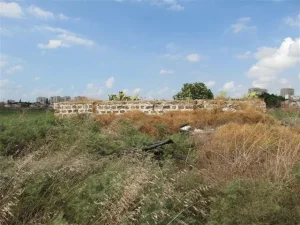
A few rubble-strewn areas remained, with cypress and fig trees, Christ's-thorn, and castor-oil plants growing among the ruins.
Several Palestinian houses were still standing and had been incorporated into Tel Aviv's street grid alongside newer residential and commercial buildings.
This description should not be treated as a comprehensive field verification of conditions in 2026. Fieldwork for All That Remains was conducted between 1987 and 1990 and therefore records the condition of the site during that survey period.
Sources
- PalQuest – Interactive Encyclopedia of the Palestine Question: al-Jammasin al-Sharqi
- Palestine Remembered – al-Jammasin al-Sharqi, Jaffa District
- Palestine Remembered – Walid Khalidi's account of al-Jammasin al-Sharqi
- Palestinian Villages Encyclopedia – al-Jammasin al-Sharqi; supporting Palestinian documentation
- WAFA – Palestinian towns and villages occupied and depopulated in 1948
- Census of Palestine 1931 – al-Jammasin al-Sharqi: 395 inhabitants in 29 houses
- Institute for Palestine Studies – Walid Khalidi, All That Remains
- PalQuest – All That Remains: Methodology
Photos from the village's people
Photos sent in by visitors and published after review.
Add a photo of this village
Log in to add photos of this village.
Other villages from Jaffa
More from the archive
 Download Our Palestine App
The whole archive in the palm of your hand: depopulated villages, the Nakba, the massacres and Al-Aqsa — free, with no ads to erase the story.
Download Our Palestine App
The whole archive in the palm of your hand: depopulated villages, the Nakba, the massacres and Al-Aqsa — free, with no ads to erase the story.



Comments
No comments yet — be the first to write one.
Add your comment
Name and email are optional. Comments appear after review.