
The depopulated village of Qatra / District of Ramla
Subdistrict: Ramla Subdistrict
Estimated population of Qatra in 1948: 1,404, commonly rounded to approximately 1,400
Date of occupation: 6 May 1948; the displacement of the population took place over the following days
Military unit: Givati Brigade; an official Haganah account attributed the occupation to the Alexandroni Brigade, probably in error
Israeli settlements established on Qatra’s land before 1948: Gedera, established immediately south of the village in 1884; many of its buildings later extended onto Qatra’s land
Israeli settlements established on Qatra’s land after 1948: Kidron, established in 1949
Qatra was located approximately 15 kilometres southwest of al-Ramla.
Qatra, also known during the British Mandate as Qatrat Islam, was a Palestinian village approximately 15 kilometres southwest of al-Ramla. Its location was important because of its proximity to the principal paved road linking Gaza and Yafa. The village was also approximately 31 kilometres southeast of Yafa and about 52 kilometres from Gaza. Secondary roads connected it with Bashshit, Shahma, al-Maghar, al-Mukhayzin, Aqir, and al-Masmiyya al-Kabira. The Aqir military airfield was located approximately 3 kilometres northeast of the village.
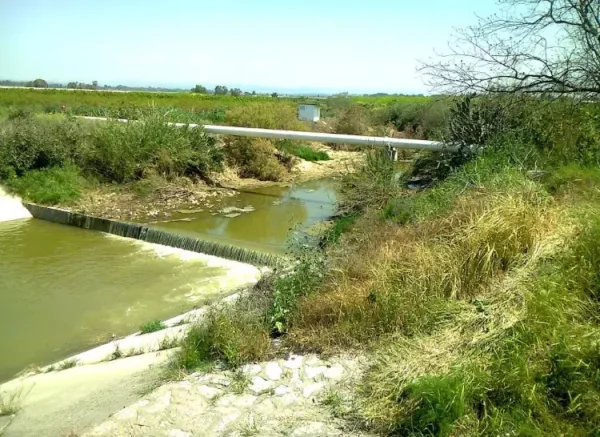
The village stood on an elevated area underlain by limestone on the central coastal plain, approximately 1 kilometre south of Wadi al-Sarar. Its houses were constructed from adobe or cement and were surrounded by gardens.
During the British Mandate, the village was also called Qatrat Islam to distinguish it from Qatrat Yahud, the adjacent Jewish settlement known as Gedera. A mosque, a coeducational elementary school, and several shops stood in the centre of Qatra. The inhabitants were predominantly Palestinian Muslims, and agriculture was their principal source of livelihood because of the fertile soil and plentiful groundwater.
Boundaries of Qatra
Qatra was situated among the following Palestinian villages and towns:
- North: al-Maghar.
- Northwest: Yibna.
- West: Bashshit.
- Southwest: Yasur.
- South: al-Masmiyya al-Kabira.
- Southeast: al-Mukhayzin.
- East: Shahma.
- Northeast: Aqir.
Architecture of Qatra
In the late nineteenth century, Qatra was described as a village of adobe houses surrounded by gardens. During the British Mandate, it had a rectangular layout, and its houses were built from either adobe brick or cement. A mosque and several shops stood in the village centre. New houses were later constructed on former agricultural land, causing the built-up area to expand towards the southeast.
Land of Qatra
Qatra’s land covered 7,853 dunams. Of this area, 5,130 dunams were under Palestinian ownership, 2,509 dunams were under Jewish ownership, and 214 dunams were classified as public land. The village lands were known for their fertile soil and plentiful groundwater.
Land Ownership in Qatra
| Ownership category | Land area (dunams)* |
|---|---|
| Palestinian ownership | 5,130 |
| Jewish ownership | 2,509 |
| Public land | 214 |
| Total | 7,853 |
* One dunam equals approximately 1,000 square metres.
Land Use in Qatra in 1944–1945
| Land-use category | Palestinian ownership (dunams)* | Jewish ownership (dunams)* | Public land (dunams)* | Total (dunams)* |
|---|---|---|---|---|
| Citrus and banana cultivation | 391 | 404 | 0 | 795 |
| Irrigated land and orchards | 215 | 373 | 0 | 588 |
| Cereal cultivation | 4,320 | 1,639 | 0 | 5,959 |
| Built-up area | 26 | 0 | 0 | 26 |
| Cultivable land | 4,926 | 2,416 | 0 | 7,342 |
| Uncultivated land | 178 | 93 | 214 | 485 |
* One dunam equals approximately 1,000 square metres.
Population of Qatra
Qatra’s population increased from 640 in the 1922 British Mandate census to 822 in 1931, when its inhabitants lived in 175 houses. The official 1945 village statistics recorded 1,210 inhabitants, predominantly Palestinian Muslims. The population in 1948 has been estimated at 1,404, a figure commonly rounded to approximately 1,400.
Israeli forces occupied Qatra in May 1948 during the Nakba. Its Palestinian inhabitants were either compelled to flee or expelled over the following days, and much of the village was subsequently destroyed.
Population Records for Qatra
| Year | Population* |
|---|---|
| 1922 | 640 |
| 1931 | 822 |
| 1945 | 1,210 |
| 1948 | 1,404 |
| Estimated number of refugees in 1998 | 8,620 |
* The figures for 1948 and 1998 are demographic estimates rather than contemporaneous census counts. Estimates vary between sources.
Number of Houses in Qatra
| Year | Number of houses* |
|---|---|
| 1931 | 175 |
| 1948 | 298 |
* The 1931 figure is an official census count, while the 1948 figure is an estimate.
Economic Life in Qatra
Agriculture was the principal source of livelihood in Qatra, supported by fertile soil and plentiful groundwater. The villagers cultivated cereals, vegetables, and fruit. Some crops depended on rainfall, while others were irrigated with water drawn from artesian wells. Orchards and cultivated fields surrounded the village on all sides.
In 1944–1945, 391 dunams under Palestinian ownership were devoted to citrus and bananas, 4,320 dunams to cereal cultivation, and 215 dunams to irrigated agriculture or orchards. Olive trees covered 30 dunams within the latter category.
Education in Qatra
A coeducational elementary school was established in the village in 1923. By the mid-1940s, it had an enrollment of 123 boys and 8 girls.
Archaeological Remains in Qatra
- Modern Qatra was constructed over a site containing remains from the Roman and Byzantine periods, including building foundations, ceramic fragments, and mosaic floors. The village has also been tentatively identified with the Hellenistic town of Kidron, also known as Cedron or Gedrus.
- Local inventories identify additional archaeological locations on Qatra’s land, including sites known as al-Nabi Arafat and Tall al-Ghul. Their precise chronology and identification could not be confirmed from the principal academic sources consulted.
Occupation and Depopulation of Qatra
The earliest documented Haganah military activity at Qatra occurred on 13 March 1948. According to the Palestinian newspaper Filastin, a shooting incident involving Palestinian fruit pickers working in an orchard left five workers wounded. The available account does not state that they were killed.
On 17 April 1948, after the British authorities evacuated the nearby police fortress, Haganah squads moved into it. Israeli historian Benny Morris states that units of the Givati Brigade surrounded Qatra on 6 May and demanded that the villagers surrender all their weapons. Several dozen armed men attempted to leave the encircled village but were stopped by Haganah forces.
The villagers subsequently handed several rifles to the Givati troops, who nevertheless entered the village. Soldiers then began looting property, during which one soldier was shot and killed by a villager. Haganah forces arrested several residents. According to Morris, the remaining population was either intimidated into leaving or ordered to leave within the following days.
The official Haganah account similarly places Qatra’s occupation during this period but attributes it to the Alexandroni Brigade. Walid Khalidi notes that this attribution was probably erroneous, while the better-supported account identifies the Givati Brigade as the principal occupying formation. Other research places the completion of the village’s depopulation around 17 May 1948. The evidence therefore distinguishes the military entry of 6 May from the displacement process that continued over the following days.
Israeli Settlements Established on the Land of Qatra
- Gedera was established immediately south of Qatra in 1884, not in 1948. It later developed into a town, and many of its buildings stand on land belonging to the Palestinian village.
- Kidron was established on Qatra’s land in 1949. It is therefore more accurate to state that Kidron itself, rather than merely a portion of it, was built on village land.
Qatra Today
Only the former school and several deserted houses remain from the Palestinian village. Cactus plants and a number of palm trees grow across the site, while the surrounding village lands are cultivated by Israelis.
Sources
- Interactive Encyclopedia of the Palestine Question – Qatra.
- Palestine Remembered – Qatra.
- Government of Palestine, Village Statistics, April 1945.
- Walid Khalidi, All That Remains: The Palestinian Villages Occupied and Depopulated by Israel in 1948, Institute for Palestine Studies, 1992, pp. 404–405.
- Government of Palestine, Palestine: Report and General Abstracts of the Census of 1922.
- Government of Palestine, Census of Palestine, 1931: Population of Villages, Towns and Administrative Areas.
Photo gallery


Photos from the village's people
Photos sent in by visitors and published after review.
Add a photo of this village
Log in to add photos of this village.
Other villages from Ramla

 Download Our Palestine App
The whole archive in the palm of your hand: depopulated villages, the Nakba, the massacres and Al-Aqsa — free, with no ads to erase the story.
Download Our Palestine App
The whole archive in the palm of your hand: depopulated villages, the Nakba, the massacres and Al-Aqsa — free, with no ads to erase the story.



Comments
No comments yet — be the first to write one.
Add your comment
Name and email are optional. Comments appear after review.