
The depopulated village of Mirun / District of Safed
About the depopulated village of Mirun
- District
- Safed
- Date Mirun was occupied
- 29 October 1948
- Population in 1948
- 340
- Military operation
- Operation Yiftach
- Brigade that carried it out
- The Seventh Brigade، The Carmeli Brigade
- Distance from the governorate centre
- 5 (km) West of Safad
- Elevation above sea level
- 750 m
- Cause of displacement
- Influence of fall of, or exoduce from, neighboring town
- Extent of destruction
- Mirun has been mostly destroyed with the exception of few rooms and rubble of destroyed houses.
- Ethnic cleansing
- The village was ethnically cleansed in two waves: the 1st was shortly after the capture of Safad by the Haganah on 10 May 1948, and the 2nd wave was by the end of October 1948.
Hover a dot to read the village name, or click to open its card.
Borders of the depopulated village of Mirun
Mirun: A Depopulated Palestinian Village in the Safad District
Mirun was a Palestinian village in the Safad District, located approximately 5 km west of Safad, slightly to the north, on the rocky and gently sloping eastern foot of Mount al-Jarmaq at an average elevation of about 750 metres above sea level. Its Palestinian inhabitants were displaced in two principal waves during the Nakba and the occupation of Palestine in 1948: the first shortly after the fall of Safad on 10 May, and the second after Mirun itself was finally occupied on 29 October during Operation Hiram, following resistance to units of the Sheva' (Seventh) and Carmeli brigades.
Location of Mirun
Mirun stood on the rocky, gently sloping eastern foot of Mount al-Jarmaq, the highest mountain in Palestine, overlooking the hilly landscape of Upper Galilee.
The village was approximately 5 km west of Safad, with a slight northerly inclination, and had an average elevation of about 750 metres above sea level.
Wadi Mirun ran south of the village and formed its southern boundary.
The village stood west of the Acre–Safad highway, which passed approximately half a kilometre to its east, and the built-up area extended on a northwest–southeast axis.
Nearby Palestinian localities included Qaddita, Safsaf, 'Ayn al-Zaytun, al-Sammu'i, and lands extending toward Bayt Jann and other Upper Galilee villages.
The Name Mirun
Palestine Remembered gives an interpretation deriving Mirun from a Canaanite name rendered as “Merom,” associating it with elevation, and also records an ancient form rendered as Meroth.
Khalidi's principal PalQuest entry does not itself establish this etymology as a documented historical explanation of the village's name.
The interpretation is therefore attributed to Palestine Remembered rather than presented as a conclusively established linguistic origin.
Mirun through History
The Arab geographer al-Dimashqi, who died in 1327, mentioned Mirun as a village near Safad situated close to a well-known cave.
He reported that Jews, and perhaps other inhabitants of the area, visited the cave during a religious festival to witness what they regarded as a miraculous rising of water from basins and sarcophagi.
Khalidi considers it likely that al-Dimashqi was describing the Lag ba-'Omer pilgrimage associated in Jewish tradition with the anniversary of the death of the Talmudic sage Rabbi Shim'on bar Yochai, whose tomb is traditionally identified at the site.
In 1596, Mirun was a village in the nahiya of Jira within the liwa of Safad, with an estimated population of approximately 715.
The inhabitants paid taxes on goats and beehives, as well as on a press used to process olives or grapes.
In the late nineteenth century, travellers described Mirun as a small village at the foot of the high hills of Mount al-Jarmaq. Its approximately fifty inhabitants cultivated extensive olive groves north and northeast of the village.
Architecture of Mirun
The houses of Mirun were closely clustered.
Until at least the 1931 census, the settlement consisted of two quarters: a larger Arab quarter in the northwest and a smaller Jewish quarter in the southwest around the tomb traditionally associated with Shim'on bar Yochai.
The houses in both quarters stood close together within the village settlement.
In the 1944/45 land-use statistics, the built-up area totaled 41 dunums: 31 Arab dunums and 10 Jewish dunums.
Population of Mirun
The official 1922 Census of Palestine recorded 154 inhabitants in Mirun, all Muslim.
The 1931 census recorded 189 inhabitants living in 47 houses.
The official census table shows that the population consisted of 158 Arab Muslims and 31 Jews.
Khalidi's PalQuest narrative contains an evident typographical error stating “259 Arabs and 31 Jews.” This cannot be correct because the official total is 189. The figures used here therefore follow the official 1931 census: 158 Arab Muslims and 31 Jews.
In 1944/45, the village statistics recorded a population of 290, classified entirely as Arab.
Population of Mirun in selected years
- 1596Approximately 715Estimate derived from Ottoman records
- Late nineteenth centuryApproximately 50Historical estimate
- 1922154Official census; all Muslim
- 1931189Official census: 158 Arab Muslims and 31 Jews
- 1944/45290Official village statistics; population classified entirely as Arab
- 1948336Later estimate published by Palestine Remembered
- Estimated refugees in 19982,066Later estimate published by Palestine Remembered
Number of Houses in Mirun
Number of houses in Mirun
- 193147Official British Mandate census
- 194883Later estimate published by Palestine Remembered
Education in Mirun
Mirun had an elementary school for boys.
Mandate-era administrative documents preserved on Palestine Remembered confirm that the school was active during the early 1940s.
A November 1940 document concerns the management of the Mirun school, while a January 1941 letter from an education inspector concerns the transfer of a teacher to the village.
Khalidi's principal entry does not provide a securely documented pupil total, so no unsupported enrollment figure is added.
Economic Life in Mirun
Agriculture and livestock raising were the principal sources of livelihood.
Cereals were the main crop, followed by fruit.
In the 1942/43 season, approximately 200 dunums of village land were planted with olive trees, most of them northwest of the village.
The inhabitants used two hand-operated olive presses to extract oil.
In the 1944/45 land statistics, cereal cultivation totaled 12,563 dunums: 6,732 Arab dunums, 5,829 Jewish dunums, and 2 public dunums.
The 200 dunums of olive groves should not be added again to the 1944/45 total because they describe a particular crop in the earlier 1942/43 season.
Land Ownership in Mirun
The total registered land area of Mirun was 14,114 dunums in the 1944/45 statistics.
Land ownership in Mirun, 1944/45, using Palestine Remembered's ownership terminology
- Palestinian6,765 dunums48%
- Transferred to Zionists5,839 dunums41%
- Communal1,510 dunums11%
Palestinian land represented approximately 47.9 percent of the total, land in the category “Transferred to Zionists” approximately 41.4 percent, and communal/public land approximately 10.7 percent.
Land Use in Mirun, 1944/45
PalQuest's detailed official land-use table uses the source categories Arab, Jewish, and Public. The table below preserves those source categories rather than replacing “Jewish” with a different ownership term.
Land use in Mirun according to PalQuest's detailed 1944/45 statistics
- Arab
- Jewish
- Public
- Cereals12,563 dunums
- Built-up area41 dunums
- Non-cultivable land1,510 dunums
Cultivated or cultivable land totaled 12,563 dunums, approximately 89 percent of the registered village lands.
Built-up and non-cultivable land together amounted to 1,551 dunums, approximately 11 percent of the total.
Palestine Remembered's simplified table requires two corrections when compared with PalQuest's detailed statistics. It places 6,734 dunums of cereal land in the Palestinian column, whereas the detailed table gives 6,732 Arab dunums plus 2 public dunums. It also places all 1,510 dunums of non-arable land in the Palestinian column, whereas the detailed table records only 2 Arab dunums and 1,508 public dunums.
Archaeology in and around Mirun
The area around Mirun contained extensive archaeological remains ranging from the early Roman period to the medieval era.
One of the most important sites was Khirbat Shama', approximately 1 km southeast of the village.
Excavations there uncovered the remains of a synagogue constructed in the first century BCE and no longer in use by the seventh century CE.
Other discoveries in the vicinity included a cave containing tombs and cisterns, rock-cut tombs, olive presses, and miscellaneous architectural remains.
These archaeological remains should be distinguished from the demographic character of the twentieth-century Palestinian village. Ancient Jewish remains and the traditional religious shrine at Mirun do not alter the fact that the Arab Palestinian village constituted the principal residential community in the final years of the Mandate.
The First Wave of Displacement in May 1948
Mirun's inhabitants began to be displaced months before the village itself was finally occupied.
Following the Haganah's capture of Safad on 10 May 1948, part of Mirun's population left in the first wave of displacement.
Khalidi, citing an Israeli source within his discussion, also states that some inhabitants of Safad may have sought refuge in Mirun during the fighting around the city.
Mirun was therefore drawn into the battle for the Safad area, but the fall of Safad did not mean that Mirun itself was occupied on 10 May.
The 28–29 May Yiftach Raid
On 28–29 May 1948, the First Battalion of the Yiftach Brigade raided Mirun.
The attacking force destroyed a bridge on the outskirts of the village.
Khalidi reproduces Israeli military accounts describing the raid as part of broader operations against Syrian and Lebanese forces positioned in the Galilee region.
The raid did not, however, result in the occupation of Mirun. The village remained outside Israeli control until late October.
The May Yiftach raid must therefore be distinguished from the final occupation during Operation Hiram five months later.
Operation Hiram and the Final Occupation of Mirun
Operation Hiram began on 28 October 1948 and continued through 31 October, targeting the remaining Arab-held areas of Upper Galilee.
Mirun was initially designated as one of the first villages to be occupied during the operation.
Palestinian historian Nafez Nazzal presents indirect evidence that Mirun was subjected to an air attack. Residents of Tarshiha reported that three Israeli aircraft briefly bombed Mirun shortly before nightfall on 28 October, at approximately the same time that Tarshiha was bombed.
On the ground, units of the Sheva' (Seventh) and Carmeli brigades encountered resistance from Mirun's defenders.
Because of this resistance, the attacking units temporarily bypassed Mirun and continued toward Safsaf.
After Safsaf fell on 29 October, Mirun also fell.
Khalidi reproduces an Israeli military account that attributed the village's fall to heavy losses among its defenders.
The fate of all civilians who remained in the village is not known with precision. Khalidi notes, however, that a later document of the Israeli Ministry of Minority Affairs indicated that the remaining inhabitants were expelled as punishment for the village's resistance.
- First wave of displacement: shortly after Safad fell on 10 May 1948.
- Yiftach raid: 28–29 May 1948.
- Unit responsible for the May raid: First Battalion, Yiftach Brigade.
- Result of the May raid: a bridge was destroyed; the village was not occupied.
- Operation associated with the final occupation: Operation Hiram.
- Probable air attack: evening of 28 October 1948.
- Final occupation date: 29 October 1948.
- Forces associated with the final attack: Sheva' (Seventh) and Carmeli brigades.
- Resistance: forced the attacking units initially to bypass the village and continue toward Safsaf.
- Second wave of displacement: after the village's final occupation in late October.
Why 10 May Is Not Mirun's Final Occupation Date
Palestine Remembered's summary table lists 10 May 1948 as Mirun's “occupation date.” Its own detailed historical narrative, however, as well as Khalidi's PalQuest entry, makes clear that 10 May marks the first displacement wave following the fall of Safad.
Mirun itself was not occupied at that time. It was raided without being captured on 28–29 May and remained outside Israeli control until 29 October.
The historically more precise date for the village's final occupation is therefore 29 October 1948 during Operation Hiram.
Israeli Settlement on Mirun's Lands
The Israeli settlement of Meron was established in 1949 on the Palestinian village lands.
It stands immediately north of the former village site, and Khalidi notes that it may partly occupy the village site itself.
- Meron: established in 1949 on Mirun's lands, immediately north of—and possibly partly on—the former village site.
Mirun Today
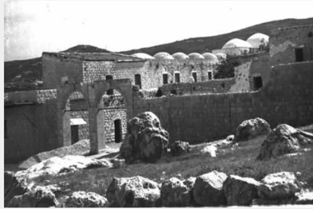
According to the field description published by Walid Khalidi in All That Remains, the Arab section of Mirun was demolished, although several rooms and stone walls remained standing.
One surviving wall contained a rectangular doorway-like opening, while another retained an arched entrance.
Grass and trees covered much of the rest of the site, which had become incorporated into the Israeli settlement of Meron.
Parts of the surrounding lands were planted with apple trees, other areas were forested, and some land was used for livestock grazing. The area also became a tourist destination.
Palestine Remembered preserves later community-contributed documentation, including 2003 photographs of the Mirun spring, mill remains, houses, and archaeological features, as well as contributor images uploaded in May and June 2025 showing surviving structures and walls.
Additional Mandate-era documents concerning the school and land disputes were uploaded to Palestine Remembered in 2026. Their upload dates should not be confused with contemporary field documentation.
The later photographs are valuable community evidence but do not constitute a systematic independent survey of every part of the village site.
The principal field description therefore remains Khalidi's historical documentation. The approved sources used here do not provide a sufficiently comprehensive independent 2026 field survey to establish the precise present condition of every surviving feature of Mirun.
Sources
- PalQuestPalQuest – Interactive Encyclopedia of the Palestine Question: Mirun
- PalQuestPalQuest – Operation Hiram
- Palestine RememberedPalestine Remembered – Mirun, Safad District
- Palestine RememberedPalestine Remembered – Mirun entry from All That Remains
- Palestine RememberedGovernment of Palestine – Census of Palestine, 1931
- Palestine RememberedGovernment of Palestine – Village Statistics, 1945
- Palestine RememberedPalestine Remembered – 1941 Mandate-era document concerning Mirun school
- Institute for Palestine StudiesInstitute for Palestine Studies – All That Remains, Walid Khalidi
Photo gallery


Photos from the village's people
Photos sent in by visitors and published after review.
Add a photo of this village
Log in to add photos of this village.
Other villages from Safed


More from the archive



 Download Our Palestine App
The whole archive in the palm of your hand: depopulated villages, the Nakba, the massacres and Al-Aqsa — free, with no ads to erase the story.
Download Our Palestine App
The whole archive in the palm of your hand: depopulated villages, the Nakba, the massacres and Al-Aqsa — free, with no ads to erase the story.



Comments
No comments yet — be the first to write one.
Add your comment
Name and email are optional. Comments appear after review.